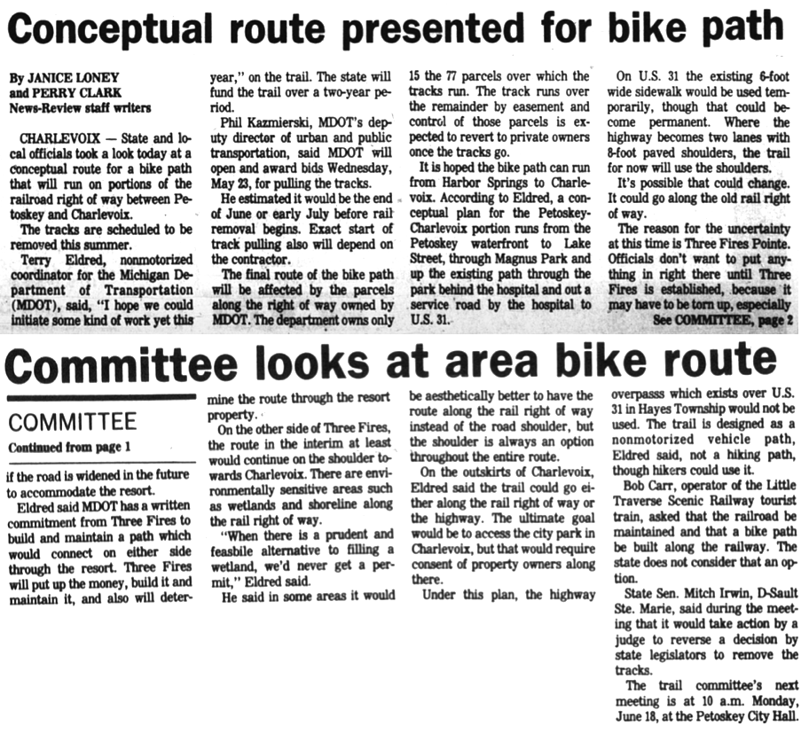
Northern Mich~Mash Preserve
~ PROPERTY ~
(AND WHEELWAY & Cemetery Riverine)
Wheelway information is included beginning
about a quarter way down on this web page.
Cemetery Riverine Fill, with county approval toward bottom also.
~ PUBLICLY SPEAKING ~
The design and compilation of the text and photos on this site are copyrighted 2017.
Most posted items will enlarge by "clicking" on them.
"Clicking" on some color highlighted words may access additional information.
Please do not copy the photos on this site, many of which have been submitted by private individuals...
just come back and visit the site often to view the photos.
just come back and visit the site often to view the photos.
Photo Labels Include:
ECBOC = Emmet County Board of Commissioners (Minutes~Legal Documents)
Finance Committee Meeting Minutes ~ Dissolved in January 2017 (Minutes~Legal Documents)
ECBOC = Emmet County Board of Commissioners (Minutes~Legal Documents)
Finance Committee Meeting Minutes ~ Dissolved in January 2017 (Minutes~Legal Documents)

13 December 2016 ~ B&G Public Meeting Comment (These minutes were not approved due to committee disbandment.)
13 December 2016 ~ B&G Public Meeting
Public Comment Below: ECBOC were considering trading away the back portion of property owned by Emmet County in the Mackinaw City location of the Emmet County Ambulance facility. A location for Public Transportation needed to be considered for the future. Trading away the property is exactly what that "Lame Duck" ECBOC did during one of their last meetings while still in office in 2016, rather than allow the newly elected ECBOC to decide.
13 December 2016 ~ ECBOC Ad-Min Meeting Public Comment
10 April 2017 ~ ECBOC COTW Publlic Comment
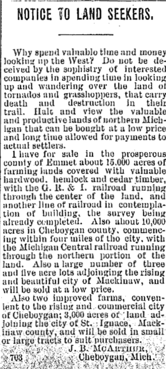
~ Purchasing and Selling Land in Emmet County ~
1881, 1882, AND 1891
1881, 1882, AND 1891
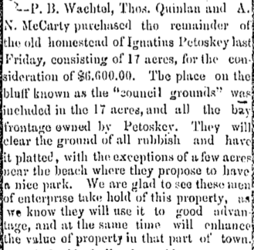
The remainder of the old homestead of Ignatius Petoskey was sold in September 1881
(including the "council grounds").
(including the "council grounds").
20 September 1881 ~ Emmet County Independent
|
22 September 1881 ~ Petoskey City Record
|
1882
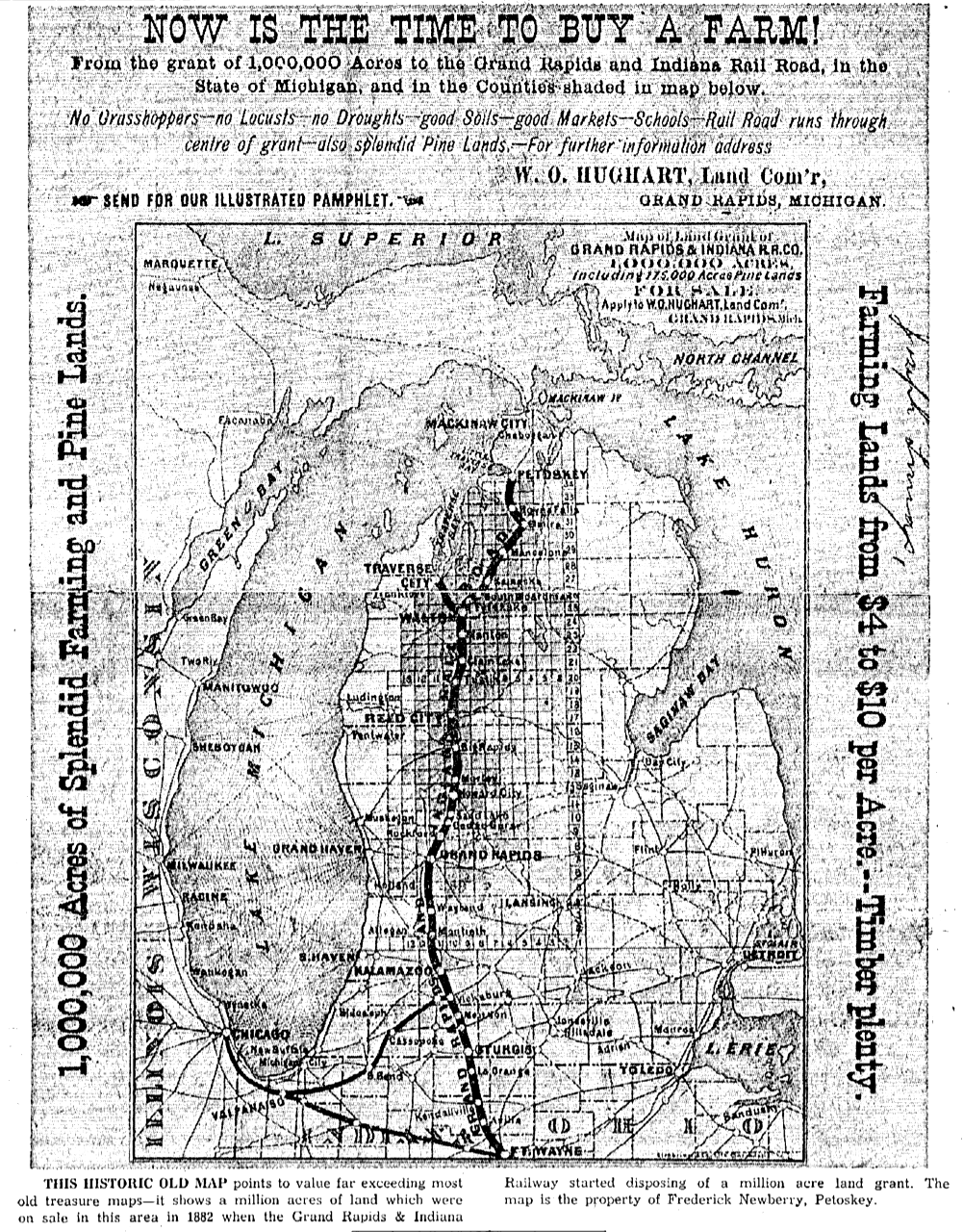
18 July 1956 ~ Petoskey News Review

18 July 1956 ~ Petoskey News Review
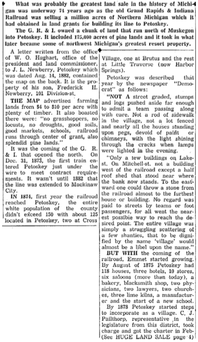
18 July 1956 ~ Petoskey News Review article continued below...
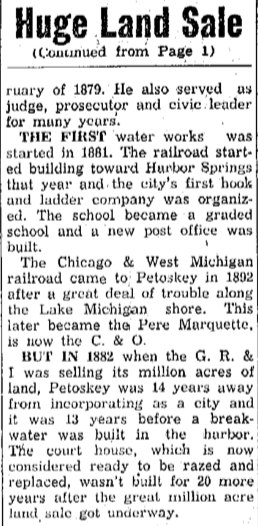
18 July 1956 ~ Petoskey News Review article continued from above...
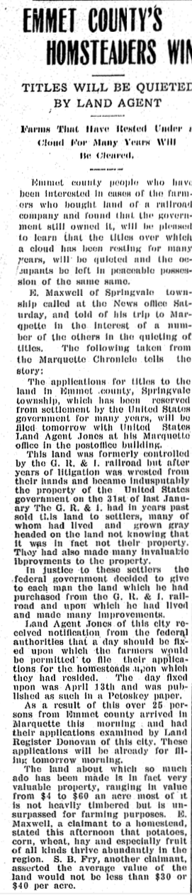
1891
14 January 1891
~ Emmet County Homesteaders Gain Quieted Title to Their Land ~
1909
1909
19 April 1909 ~ Petoskey Evening News
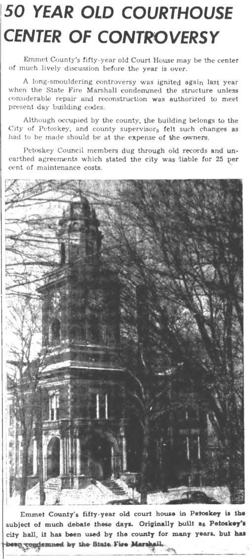
~ County Court House Controversy ~
1954
1954
28 January 1954 ~ Emmet County Graphic article continued below...

28 January 1954 ~ Emmet County Graphic article continued from above...
~ Bear Creek GIVES Petoskey 195 Acres for Industry Park ~
1959
How much new industry was attracted???
1959
How much new industry was attracted???

3 March 1959 ~ Petoskey News Review
~ Emmet County Survey Markers ~
1960
1960
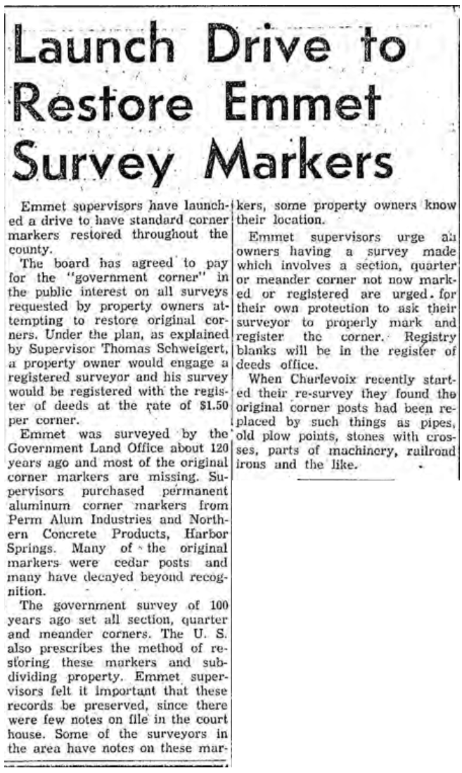
15 February 1960 ~ Petoskey News Review
~ 99 Year Lease by County on Prime Property next to the Harbor Airport ~
1965 > ...
1965 > ...

3-9 November 1965 ~ Harbor-Lite
|
"The 14 October 2020 Petoskey News Review reported: "The Jervis B. Webb Company has announced plans to consolidate all of its Northern Michigan manufacturing facilities at a new 210,000 square foot factory in Boyne City." The plan is to consolidate the two current operations in Boyne City and Harbor Springs into one new facility.
When in Harbor Springs the company actually was leasing property (see article at left) from the county, located right next to the Harbor Springs Airport. In Boyne City, the new plant will be located on a 22 acre triangular piece of property due east of the Boyne City Air Industrial Park; property owned by the City of Boyne City, but located in Boyne Valley Township. Presently, the Harbor Springs company employs 86 people, some who live in the northern Emmet County and Cheboygan areas who will not want to move for realistic commuting to work in Boyne City. |
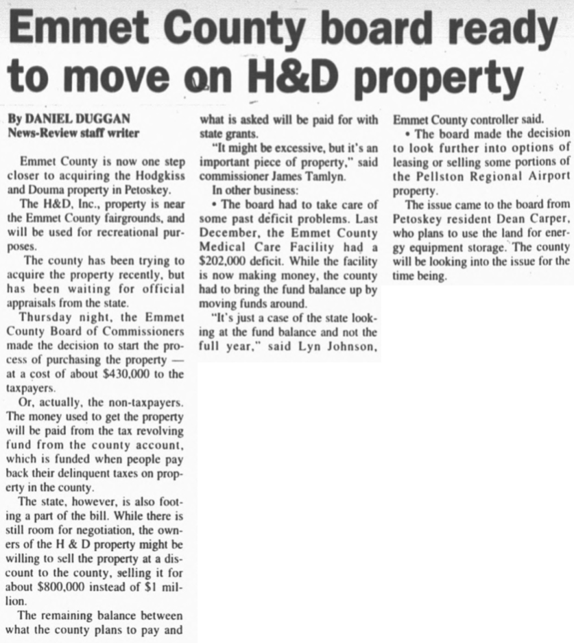
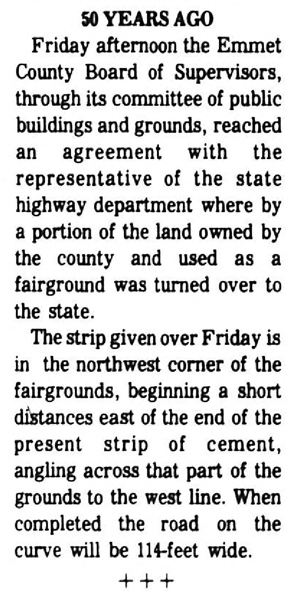
~ Emmet County Buys 159 Acres as Future Fairgrounds Site ~
1970
(This property was never used as Fairgrounds.
The Emmet County Road Commission's main office is located on a portion of this property
at 2265 Hathaway Road, Harbor Springs, Michigan.)
1970
(This property was never used as Fairgrounds.
The Emmet County Road Commission's main office is located on a portion of this property
at 2265 Hathaway Road, Harbor Springs, Michigan.)
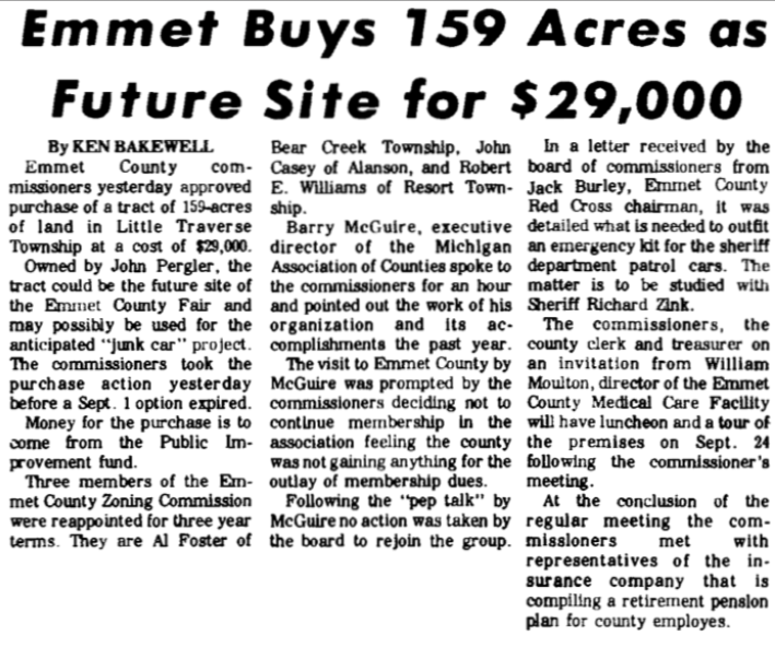
28 August 1970 ~ Petoskey News Review
In 2021, and some previous years, the Petoskey Academy of Miniature Aircraft leases from Emmet County
a small portion of this same Hathaway property for their recreational programs and activities.
a small portion of this same Hathaway property for their recreational programs and activities.
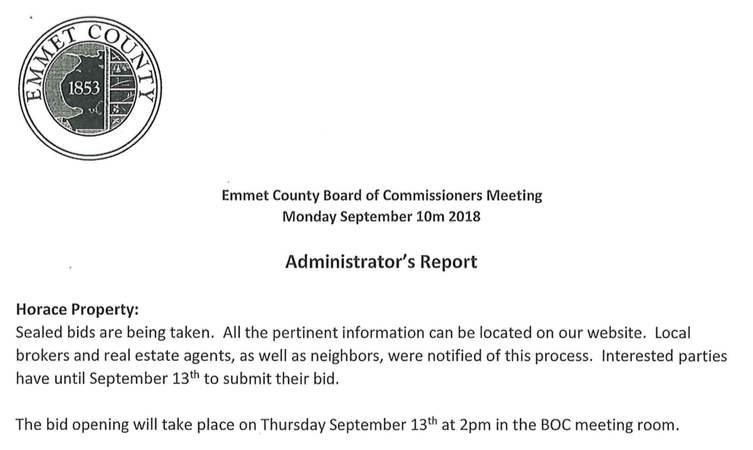
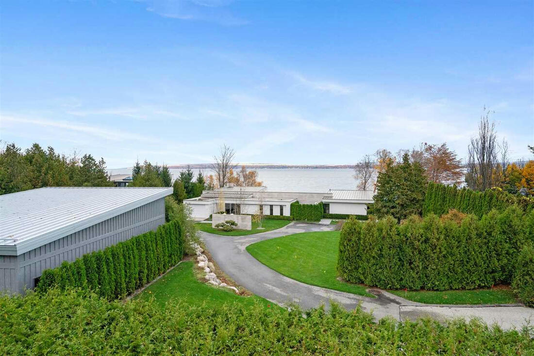
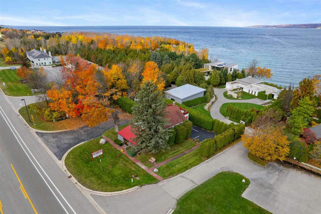
~ Horace Property ~
Owned by Emmet County (2006 until 2018) - Located 2684 Charlevoix Avenue, Petoskey, Michigan
Owned by Emmet County (2006 until 2018) - Located 2684 Charlevoix Avenue, Petoskey, Michigan
Imagine the "Forever Unobstructed View" of this property with the cedars and the fireplace removed...
Emmet County's "most prime piece of property".
Emmet County's "most prime piece of property".
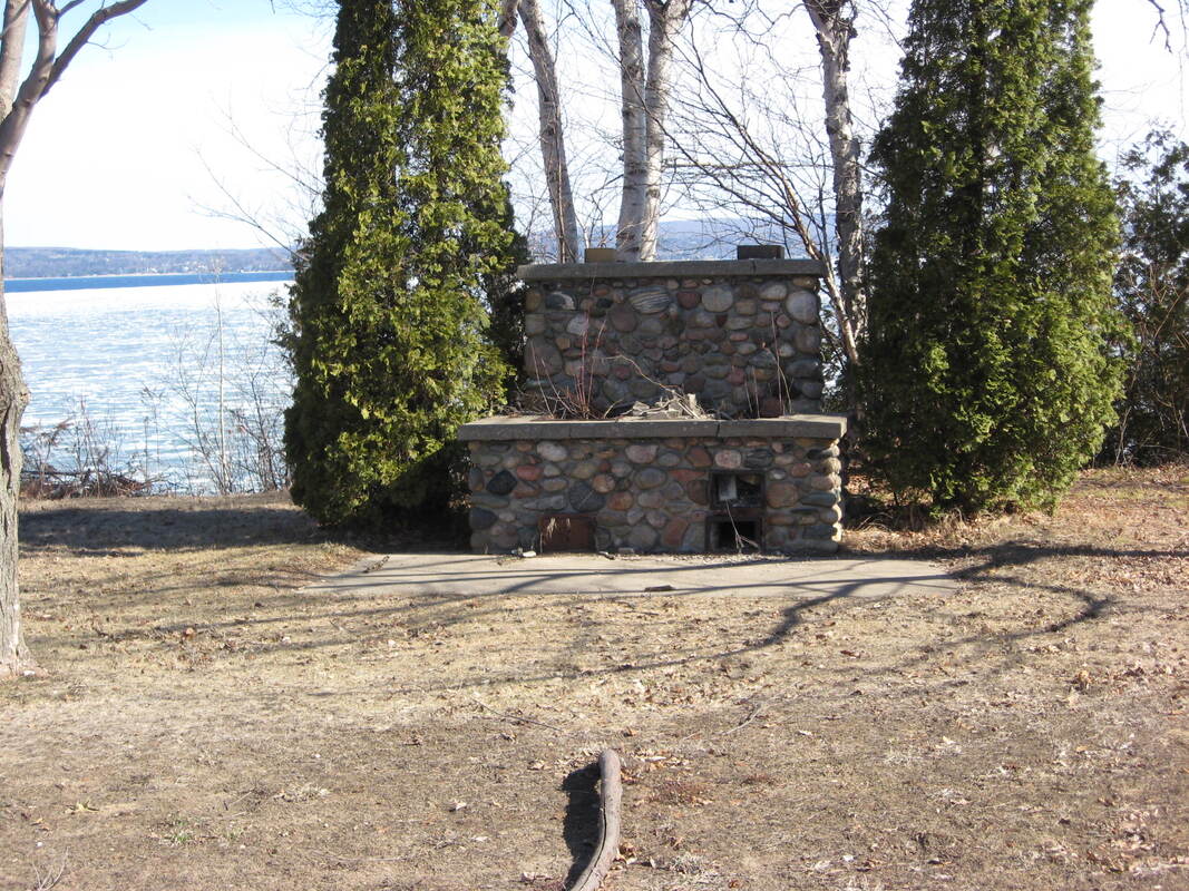
2018 or before... Emmet County Property Search Photo for 2684 Charlevoix Avenue, Petoskey, Michigan
Five Photos Below: These buildings were not wonderful, but they had no future purpose when the county originally purchased the property for $600,000.00 in 2006, mainly, for giving a lease to the Wheelway Trail for bikes on the beach below the bluff.
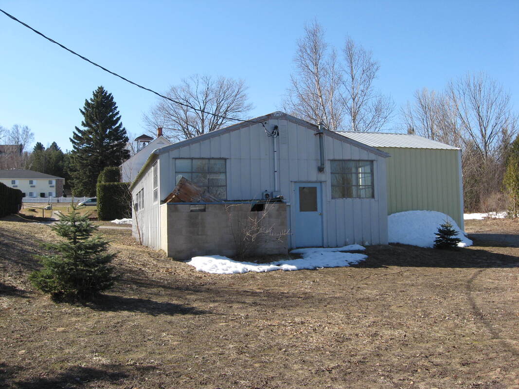
2018 or before... Emmet County Property Search Photo for 2684 Charlevoix Avenue, Petoskey, Michigan
|
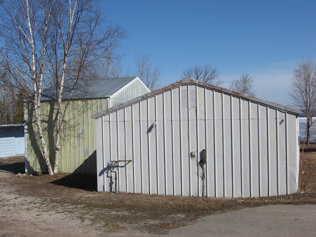
2018 or before... Emmet County Property Search Photo for 2684 Charlevoix Avenue, Petoskey, Michigan
|
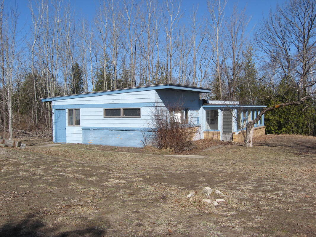
2018 or before... Emmet County Property Search Photo for 2684 Charlevoix Avenue, Petoskey, Michigan
|
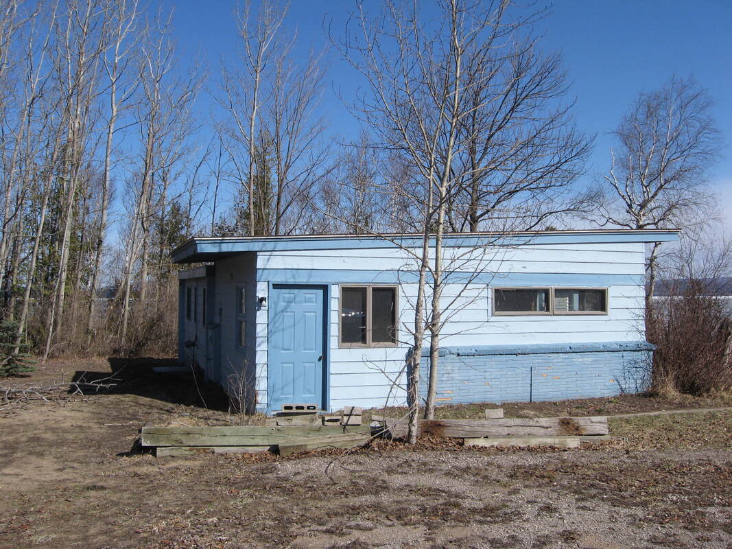
2018 or before... Emmet County Property Search Photo for 2684 Charlevoix Avenue, Petoskey, Michigan
|
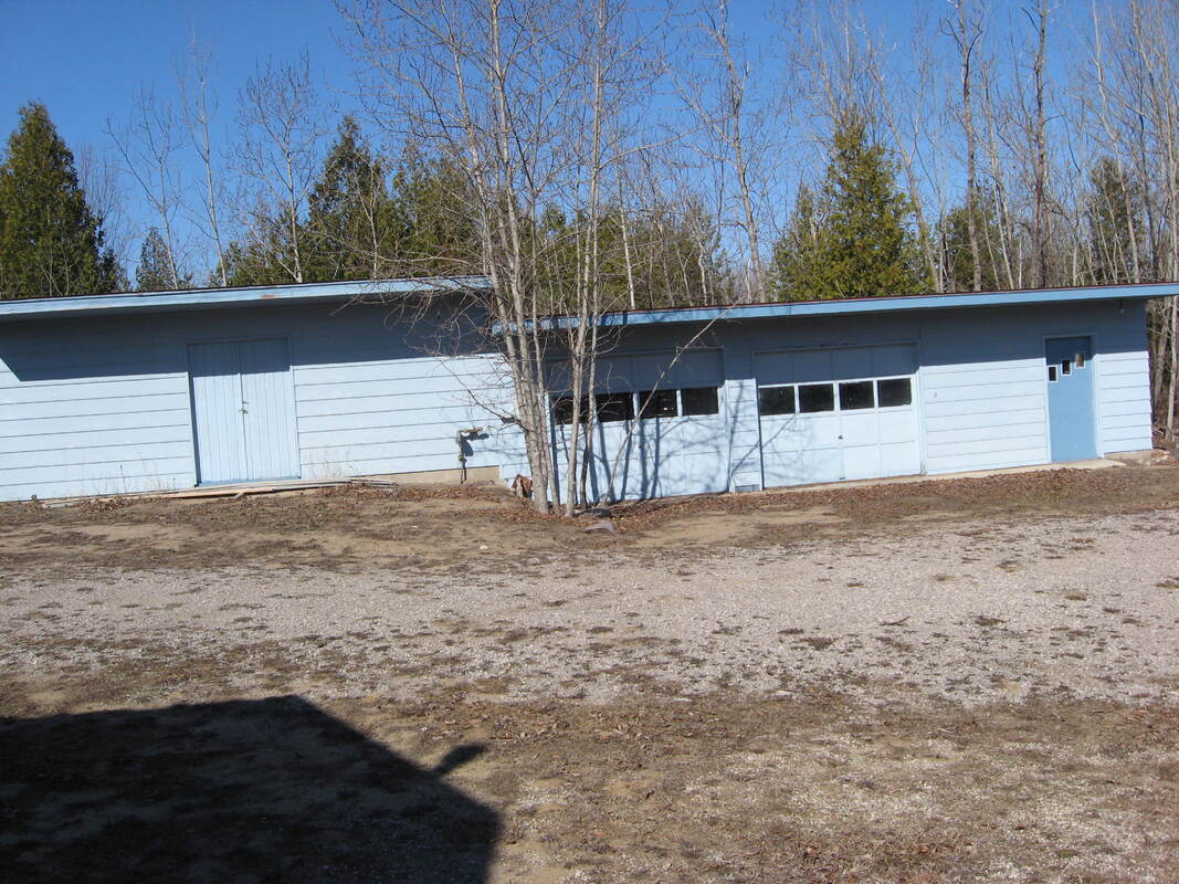
2018 or before... Emmet County Property Search Photo for 2684 Charlevoix Avenue, Petoskey, Michigan
|
View the Slideshow below by clicking Play in the upper left corner of the main photo.
The photos include the buildings on the Horace Property and the view.
The photos include the buildings on the Horace Property and the view.
Two mappings below from Emmet County Equalization/GIS Department: The red arrows are pointing out the 2684 Charlevoix Avenue, Petoskey, Michigan, property also referenced as "The Horace Property." This property (parcel number shown as 300-024) is located behind Joseph's World Art & Antiques which is directly on 2680 Charlevoix Avenue, AND overlooking Little Traverse Bay with the viewable bike trail easement over the bluff at water level.
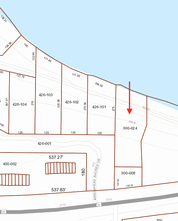
Emmet County Equalization/GIS Department
|
Emmet County Equalization/GIS Department
|
13 April 2009 ~ Finance Committee Meeting Minutes (Lyn Johnson was the County Controller)

13 April 2017 ~ ECBOC Minutes (John Calabrese was the Administrator)
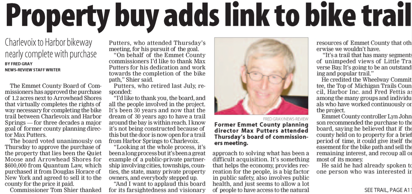
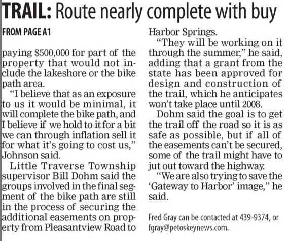
Douglas Horace sold the Lake Michigan waterfront view "Horace Property" to County of Emmet 23 May 2006 for $600,000.00. Even before 2013, the county had created an easement for the bike trail between Petoskey and Charlevoix; the county's original reason for buying the property. Also, by 17 June 2013 the Petoskey News Review reported the county was selling HALF that lake front property above the easement area for $310,000.00. That sale, however, eventually fell through.
In 2018 the Emmet County Commissioners (not all, but a majority) had committed the county's taxpayers to paying for a NON-mandated and NON-funded Public Transit. The county's budget was overextended. When the commissioners accepted the 2018 county budget, the budget was balanced on the assumption of selling the choice Horace property for $300,000.00. Commissioners had been told that the property price possibly could be higher, if the county undertook the razing of the buildings on the property to make selling more appealing to a buyer. Commissioners settled for the lower price of $300,000.00 to not have the "unknown" expense of razing. No one seemed to share any "comparables" land sites publicly at the time. The following "screenshot photos," however, captured on-line 26 May 2018 of properties for sale through Pat O'Brien's & Associates (offices in both Boyne City and Charlevoix and no association with the Horace Property sale) might have been possible "comparables."
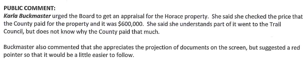
The next step in this misguided sale of county property was perpetrated when a new Sale/Disposal of County Owned Property document was accepted/approved by May or June 2018. In the document (not sure it is a policy or a procedure) the procedural process of the sale was delegated to the "Administrator and the Facilities and Assets Director," with little oversight during the actual selling process from the Board of Commissioners (the people's voices) until it reached the point of #13 – "If there is a potential sale following the sealed bid process or the licensed realtor brings an Offer to Purchase to the County, the Administrator will make a recommendation to the Board of Commissioners regarding the potential sale." By that step, all of the process of using a realtor as opposed to closed bid, having an appraisal (remains confidential, unless FOIAd), major advertising, a title search (or not) being performed; all that was needed was a rubber stamp from the commissioners... not that they had received any advisory information throughout the process.
On 31 May 2018, I wrote to the, then, county administrator about the Horace Property:
"This is the 2013 PNR article telling of ½ the property being sold for $310,000.00. So, even the previous board was smart enough to not be selling the entire property for less than the $600,000.00 that the county paid in 2006 from the general fund. I cannot believe that the Horace Property… Emmet County’s most valuable piece of secluded water view property that could possibly be sold, should even be contemplated for less than the $600,000.00 that was paid.
I told you that I remember something about the property having been surveyed to have ½ the property sold (only ½ is mentioned in the article below), but it seems that the survey was never formalized, so it probably remains one piece of property. That is fine, but I strongly urge that if the county advertises and lists the property for sale, it should START at $600,000.00. The price can always come down, but cannot easily go higher, unless a bidding war ensues.
I am, as a taxpayer, begging you to not allow the county to be TAKEN by selling this property for less than we taxpayers had invested in it in 2006!!! Even with a portion being an easement for the bike trail, the property has not devalued. Waterview property, especially with no chance that anything can ever hamper the view is not largely available for sale in Emmet County, or anywhere along the Great Lakes for that matter." ~ Karla Buckmaster
The county even jumped through the hoops of having the zoning changed on the parcel with this explanation provided: "Trying to put the Horace Property into a PUD because it is now zoned B-1 Local Tourist and Business. The Team feels if it is zoned residential it will have a better chance at sale. However, it is not adjacent to residential so needs to be zoned into a PUD. R-2 in the PUD." Also, but not mentioned, the eventual final bidder was hoping to use the property as residential.
Below Advertisement: This is one of two (8/24/18 and 8/31/18) county advertisements to promote the sale of the one of the most PRIME pieces of, not only county property, but any vacant Lake Michigan waterfront property left in the county to be sold even by a private seller. The advertisement was not in color, no picture of the "forever unobstructed view of the bay"; nothing to even visually indicate what a precious piece of PUBLIC property was being offered. That, however, was not the behind-the-scenes purpose of the advertisement. This ad merely was to fulfill the basic requirement of the new May/June 2018 "Sale/Disposal of County Owned Property" policy, not to truly entice a multitude of bidders.
The Parcel # listed in the advertisement below are incorrect, but that is how the advertisement was placed. The actual Parcel # has (ZERO) -024 as the last three digits, not just -24 as noted in the advertisement. The address was posted correctly.
The Parcel # listed in the advertisement below are incorrect, but that is how the advertisement was placed. The actual Parcel # has (ZERO) -024 as the last three digits, not just -24 as noted in the advertisement. The address was posted correctly.
Below: Members of the Emmet County Board of Commissioners were notified
THREE days before the "bid opening" was to take place on 13 September 2018 at 2PM.
THREE days before the "bid opening" was to take place on 13 September 2018 at 2PM.
A personal journal entry written on 12 May 2019 regarding the bid opening on 13 September 2018 reads: "The bid was to be a sealed bid. It would seem that NO ONE, except mandatory staff, should know ahead of time whether any other bids had transpired, or not. And, NO ONE should be telling anyone anything even just a few minutes before the opening of sealed bidding! I was at the bid opening, and it was made known [before the meeting began] that ONE bidder had been told “out in the hall” that no one else was bidding. So think, could the bidder have two envelopes (a high and a low bid) from which to choose to hand in for his bid… knowing no one else was bidding? Possibly. This process was flawed!" Then, that one bidder did not enter the room until the bid opening was in process. I was the only public in the room, until the commissioners' chairman arrived shortly before the opening began.
On 23 May 2006 Emmet County had purchased the Horace property for $600,000.00. Sealed bids were opened 13 September 2018. On 11 October 2018 the Emmet County sale of the Horace property for $367,000.00 was final. This was the county's most prime piece of saleable property with a view of Little Traverse Bay. This sale price is UNEXPLAINABLE to any questioning county taxpayer.
July 2022 UPDATE: Although the 2684 Charlevoix Road, Petoskey, Michigan, property has had a residence added, and is not for sale, the on-line Zillow estimate of value is $1,427,600.00.
July 2022 UPDATE: Although the 2684 Charlevoix Road, Petoskey, Michigan, property has had a residence added, and is not for sale, the on-line Zillow estimate of value is $1,427,600.00.
2023 Photo captured from an on-line Real Estate advertisement for a different piece of property than Lo's property (now with house) purchased previously from Emmet County.
2023 Photo captured from an on-line Real Estate advertisement for a different parcel than Lo's property (now with house) purchased previously from Emmet County.
29 October 1980 ~ Petoskey News Review
15 May 2006 ~ Petoskey News Review article continued below left...
15 May 2006 ~ Petoskey News Review article continued from above...
|
The article above and continued at the left stated: "Emmet County controller Lyn Johnson recommended the purchase to the board, saying he believed that if the county held on to property for a brief period of time, it could give itself the easement for the bike path and sell the remaining interest, and recoup all or most of its money. [County actually ended up losing $233,000.00]
He said he had already spoken to one person who was interested in paying $500,000 for part of the property that would not include the lakeshore or the bike path area. 'I believe that as an exposure to us [the county] it would be minimal, it will complete the bike path, and I believe if we hold to it for a bit we can through inflation sell it for what it's going to cost us,' Johnson said." |
By 2020, Emmet County Controller Johnson was deceased, but his paying a high price with taxpayers' dollars, was not justified OR maybe it was... The new 2020 county Controller/Administrator, however, made a mockery out of Johnson's price prediction when the Horace Property was sold way under value!
The "24 January 2020 screen capture" below shows the Sale Prices and dates of the Horace Property as noted farther above.
The "24 January 2020 screen capture" below shows the Sale Prices and dates of the Horace Property as noted farther above.
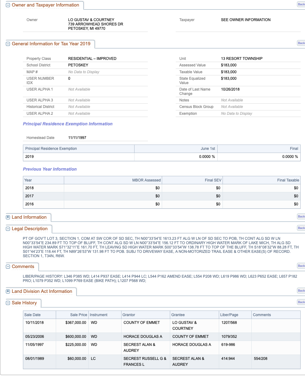
Screen capture from Emmet County's Property Search web page ~ 24 January 2020
By about 24 January 2020 discovery, and realization, of a county employee, involved with the county regarding the sale of the Horace property, allows for a probable explanation for the otherwise seemingly UNEXPLAINABLE, single and low ball bid, as mentioned above. A possible conflict of interest accounts for 1) the allowance for a low bid on the Horace property; why the minimum bid price was only $367,000,00 (not even close to the $600,000.00 the taxpayers had paid in 2006), 2) no real promotion/advertising of the sale of the property happened, either locally or statewide to entice other interested bidders, 3) no legal appraisal was presented, 4) the county completed new zoning on the property, 5) not to mention the bidder having been told ahead of time that no one else had submitted a sealed bid... thus the very real possibility of the bidder having prepared more than one bid envelope for possible presentation, just in case another bidder appeared.
In my opinion this Horace Property sale was a loss of at least $233,000.00 for the county, and its taxpayers. This prime piece of property can never be sold by the county again... just poof, be gone.
UPDATE January 2020 from Petoskey News Review Information; Click HERE: This County Administrator is no longer on staff for the county; with the commissioners agreeing to pay him a $125,000.00 buy-out. No explanations given as to whether the transition had to do with this low priced selling of the Horace Property, or for some other impropriety. All involved were sworn to secrecy!
TOP
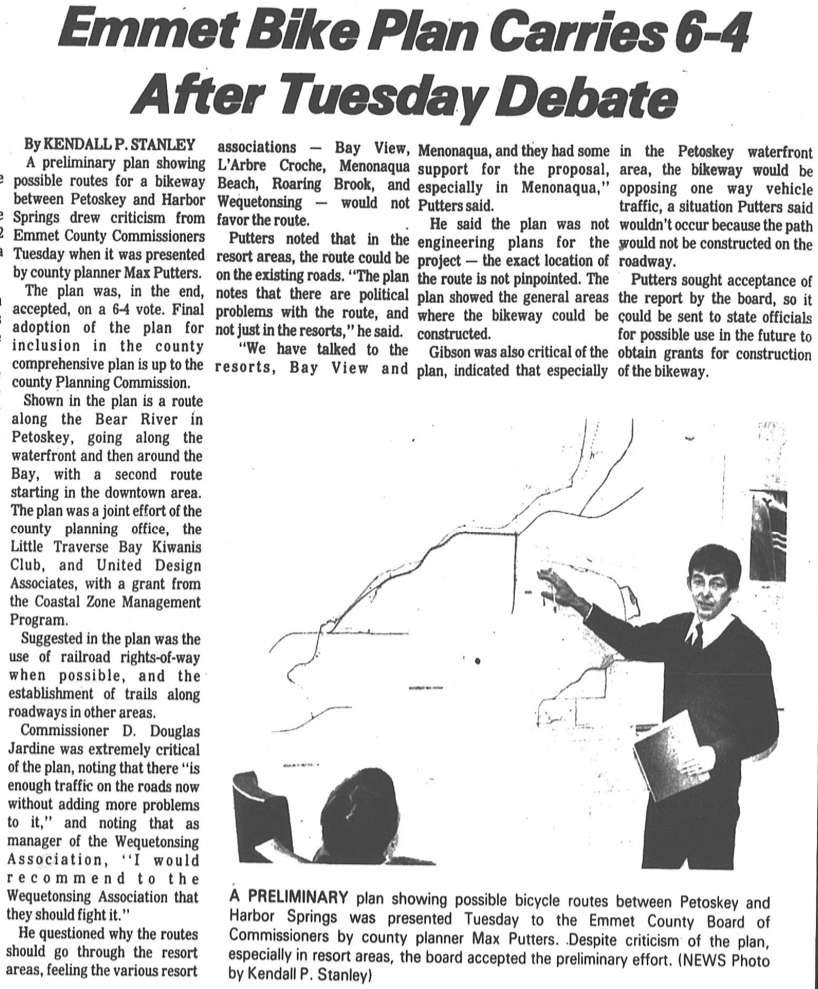
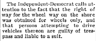
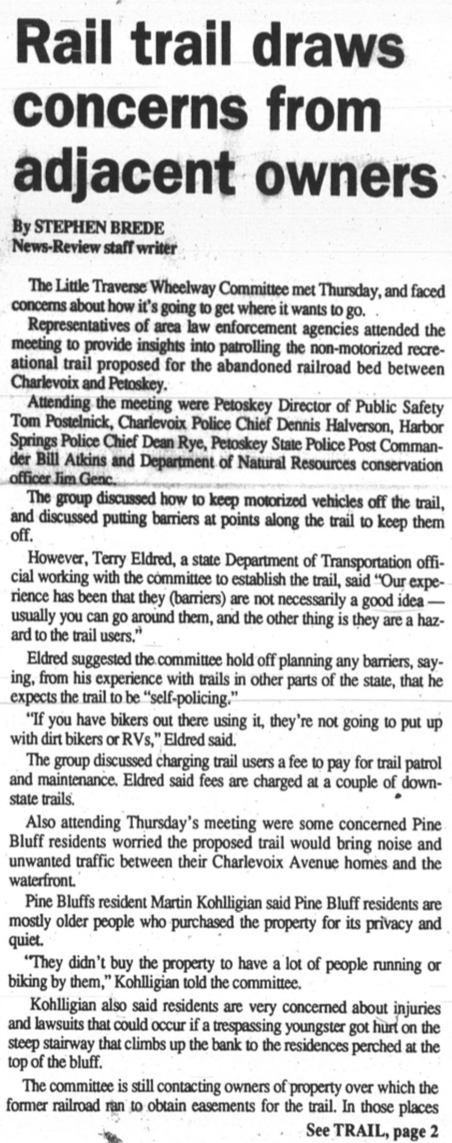
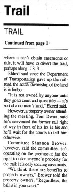
The Wheelway has been shrouded in "financial need" and maintenance since 1897.
30 June 1897 ~ The Petoskey Record
|
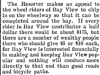
4 August 1897 ~ The Petoskey Resorter
|
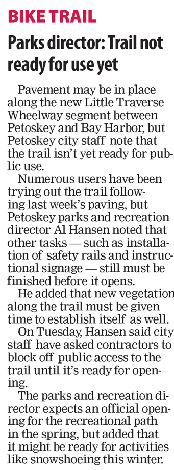
WATERFRONT WHEELWAY
20 February 2020
Repercussions From County Waterfront Rails to Trails Easements
(Little Traverse Wheelway)
Area Between Magnus Park and East Park
Repercussions From County Waterfront Rails to Trails Easements
(Little Traverse Wheelway)
Area Between Magnus Park and East Park
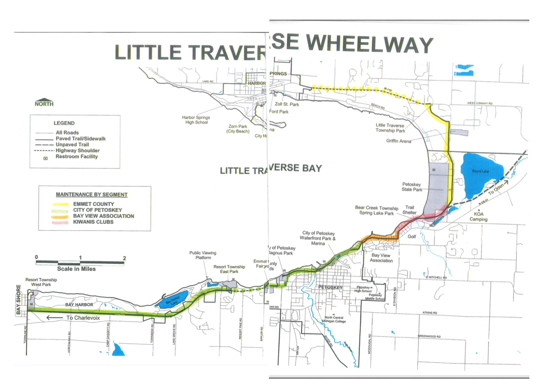
Wheelway Section of Concern as described on February 2020 Trailscouncil.org web page
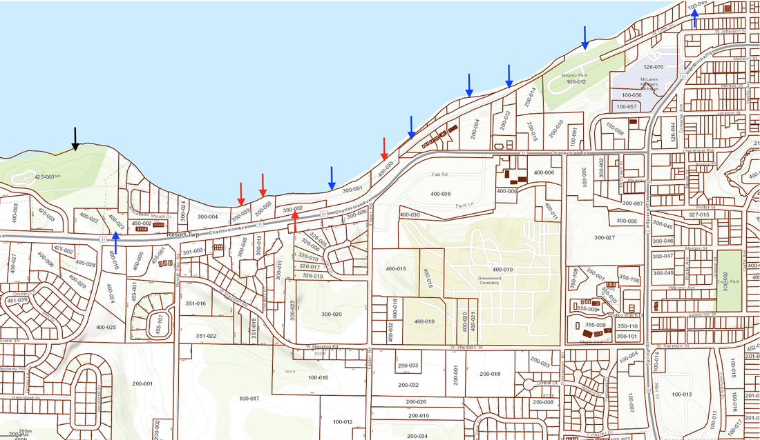
BELOW: MAP and LEGEND for Arrow Colors Identifying Property Ownership:
Black = Resort Township (East Park)
Red = Emmet County
Blue = City of Petoskey
Parcel 300-024 had been the Horace Property… so no longer county property per above noted SALE; Two properties to the left of the farthest left red arrow on the map is the Horace Property to give location orientation.
This map extends from Resort Township's East Park to the City of Petoskey's Magnus Park and a bit farther toward the city.
16 February 2020 ~ Mapping created from Emmet County GIS Map
Below: The satellite view map of the same area as above from the Wetlands Web Page shows the wetlands and riverines. For orientation purposes… the pink arrow points at the Eppler Road EMS building which was built directly over a riverine… so, it should be no surprise that the county's EMS property is experiencing water issues in 2019/2020.
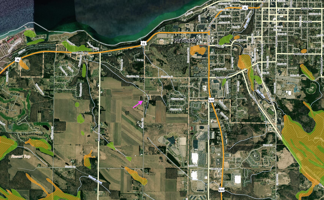
16 February 2020 ~ Map was created from the Wetlands Web Page showing Wetlands and Riverines
The 20 February 2020 Emmet County Board of Commissioners’ meeting agenda included under New Business: “Emergency Shoreline Erosion STUDY” for the cost of $81,620.00 for a "slope failure" STUDY, not including remediation which would be added later at additional costs to the taxpayers [City Manager Straebel quipped remediation could lead to costing millions]. This asking for money from the county was added to this agenda very quickly AFTER the recent 10 February 2020 Commissioners’ Committee of the Whole with no mention then of this supposed “already existing emergency.” The City of Petoskey already had approached Resort Township to share half of the STUDY cost. Resort Township passed a resolution to share the cost, IF the county would bare 1/3 of the burden with the township and the city... an interlocal agreement with governmental entities, not private property owners who also should have "skin in the game" as stated by a commissioner during the 20 February 2020 meeting. With this “emergency” the commissioners would have about one week to research and prepare for a vote on this proposed resolution. No one mentioned that any funding involvement, by Resort Township and the City of Petoskey with the addition of Emmet County, meant the citizens of the township and city would be paying TWICE, because their county taxes would also be used to pay for the same funding needs/wants.
ASIDE: In the 20 January 2020 Petoskey City Council meeting minutes the City Manager Robert Straebel reported: "correspondence from Senators Peters and Stabenow had been received concerning erosion funding issues, that a packet of information and photos will be sent to State officials later this week and a letter from the Mayor was also sent to Jason Allen, State Director of the USDA, regarding potential grants and loans for shoreline repairs." So, for one month, and previous, the city was discussing the need for shoreline repairs, but did not present anything about the topic to the ECBOC until one week before a county decision was expected to be made; an emergency!!!???
Also documented in the same city 20 January 2020 minutes as above:
"Discuss Slope Failure Study Concerning Erosion Issues
The City Manager reviewed that increasing high water and wave energy has caused substantial slope failures along the Little Traverse Wheelway, particularly between Magnus Park and Arrowhead Shores; that staff decided to close the trail between the Wastewater Treatment Plant and East Park due to potential instability of the slope and trail; that all damaged shoreline areas are within Resort Township; that staff met with Resort Township Supervisor concerning issues and proposed the concept of cost sharing for the engineering study with Resort Township and will be making an official funding request to the Resort Township Board of Trustees at their next meeting on February 11; that the City is currently working with W.F. Baird and Associates on other shoreline and marina projects and is confident they have the resources to assist providing the City with solutions; that OHM, Petoskey engineering firm, will also jointly work with Baird as part of this project; reviewed the proposal and costs; that costs weren’t included in the 2020 Budget but could be funded through the General Fund Unrestricted Reserves; and that City Council could approve the slope failure study at this meeting or wait for a decision by Resort Township.
Rory Agnew from W.F. Baird Associates gave a brief presentation on the issues of the slope failure, provided drone footage of shoreline and reviewed proposed project scope. Council agreed to make a decision on the study following the Resort Township meeting."
It is important to note that on the county’s web page is posted an RFP (Request for Proposal) for SOIL EROSION & SEDIMENTATION CONTROL CONSULTING SERVICES (OFFICE OF PLANNING & ZONING) [this has since been removed]. This follows discussions regarding erosion at the county’s property at The Headlands which was described from Emmet County documents… in the 14 January 2020 Petoskey News Review as follows: “Over the last few years, because of the rising Lake Michigan water elevation levels, ice movement, wave action and erosion has caused undermining of the large stone shoreline riprap at the Lodge (another name for the guest house)… In addition, it appears that a geotextile fabric was not originally placed below the large stone riprap and filler stone to minimize undermining of the shoreline protection.” Erosion was also identified closer to The Headlands event center. The county park director indicated to the newspaper that “the Headlands is the only water erosion problem identified so far on a county-owned piece of property, but past News-Review reports indicated that similar issues have occurred along the Little Traverse Wheelway between Charlevoix and Bay Shore, at Fisherman’s Island State Park, at Petoskey Bayfront Park and also a section of Beach Drive in Emmet County’s Little Traverse Township among other locations.”
Below are questions which need to be addressed by the ECBOC before consenting to become involved in spending taxpayer dollars on a STUDY of erosion in the area of Arrowhead Shores:
1. I question this wheelway erosion study (asking for tax dollars for a STUDY… not for a remedy) item being placed on the agenda so quickly… especially pressuring the “probably ill-informed” commissioners into making a QUICK decision to commit tax dollars to a site STUDY which will undoubtedly lead to MORE and MORE commitment of money. This STUDY item deserves more time for commissioners’ thorough research on this topic, before committing tax dollars into a bottomless water hole. [Look at the historical recorded facts about this known fragile area. Money does not have to be spent to reveal this underlying problem.]
2. Were three bids or requests for proposals taken for this Baird Company out of WI?
3. WHO, or WHAT entity, presently is contractually required to take care of this entire wheelway? Or what is the legal arrangement for addressing this erosion situation?
4. Why are the “private property” owners NOT included in the monetary commitment in the proposed resolution to contract with this Baird company to do the study?
5. Hearsay has it that any engineer who actually tries to remediate the erosion problem may be reticent to place his/her name on such a project… rather, just do whatever to make money off the taxpayers; which may, or may not fully fix the erosion problem. No engineering guarantees. [This has been Emmet County's problem in the past with engineered projects... no guarantees.]
6. I find it hard to believe that if a great deal of the erosion is created from wetlands/riverines, and not just high bay waters, that placing any type of barrier between the wheelway and the bay water could remediate the erosion. It might just trap the water from the bluff and create even more erosion as that water backs up into the bluff; rather than protecting the wheelway.
7. Check with the CHARLEVOIX County commissioners as to how they have chosen to address the wheelway erosion in their county. Hearsay has it that they have posted signs at each end of the closed section stating “Trail Ends.” [Charlevoix County's trail area has a different relationship with the MDOT.]
1911
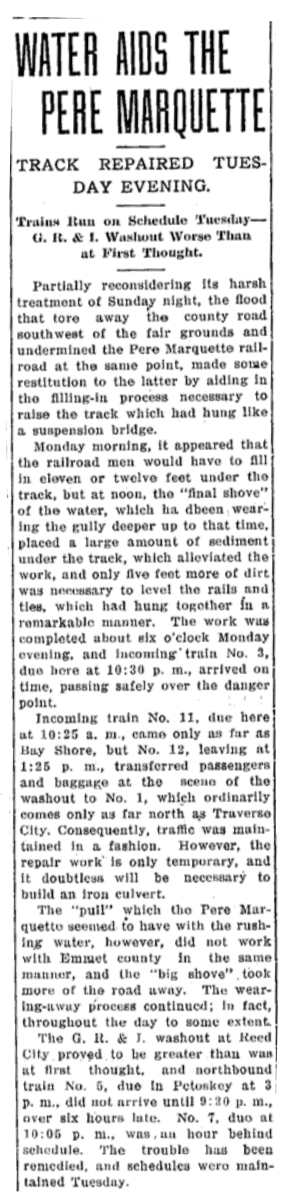
Article Below: The most terrific rain storm wreaked havoc throughout Petoskey, but the greatest damage was a washout in Charlevoix Avenue near the fair grounds, which was a part of the railroad wash, and which has taken for about fifty lineal feet all of the street, except just enough for a passage way next to the fair ground, and there is a drop of fifty feet for anyone so unfortunate as to get into it.
The largest Pere Marquette locomotive coming, found it had partially crossed a serious washout, and stopped, about opposite the fair ground. Upon investigation it was found that for about twelve feet, the track washed out, leaving a sheer drop of twenty feet down, which had it give away, would have precipitated the heavy engine about their feet, down, and into the bay.
The largest Pere Marquette locomotive coming, found it had partially crossed a serious washout, and stopped, about opposite the fair ground. Upon investigation it was found that for about twelve feet, the track washed out, leaving a sheer drop of twenty feet down, which had it give away, would have precipitated the heavy engine about their feet, down, and into the bay.

13 November 1911 ~ Petoskey Evening News
Article Below: Reverend and Mrs. G.A. Weaver, following a visit in Resort Township, found that the cutter in which they were riding dropped into a chuck hole, throwing them into the snow. The team were frightened, ran half a mile with the cutter dragging. The team did not stop for the barricade at the Washout, and plunged directly into it, down to the bottom. One horse was killed instantly, the cutter was totally demolished, and one uninjured pony was lifted almost directly up to safer ground. The Weavers were not hurt.
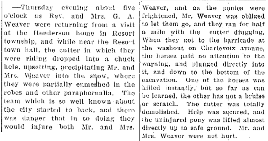
17 November 1911 ~ Petoskey Evening News
1912
Article Below: Following the horrendous Washout of 1911, and even before the MAJOR 1913 Washout, in 1912 "rain descended in floods, the wind howled and lightning darted through the sky... The most serious damages resulting from the floods was on Charlevoix Avenue, a short distance beyond the fair grounds, where the bank gave way and a large hole capable of holding several houses was made, the sand and dirt falling to the Pere Marquette railroad track which it buried to a depth of from one to five feet over an area of 150 feet in length."

2 September 1912 ~ Petoskey Evening News
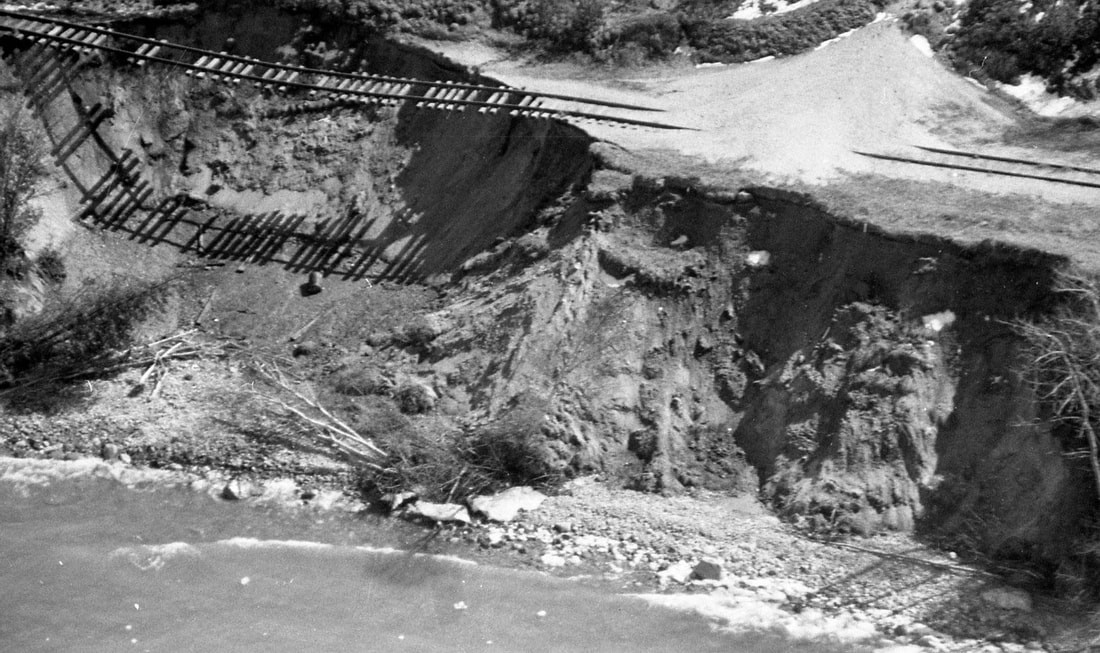
22 March 1913 ~ FIRST Report of the Big Cut/Washout
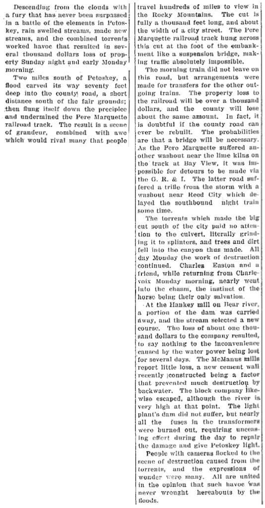
22 March 1913 ~ Petoskey Evening News
The 24 March 1913 Petoskey Evening News wrote regarding the 1913 photo below: “The cut is fully a thousand feet long, and about the width of a city street.... seventy feet deep."
At that time people could not understand how the washout could have happened and called it "a mystery" because no visible river or stream was in the area. TODAY, however, wetlands and riverines are in the realm of public knowledge, so people (even engineers) should be smarter than to try to remediate a natural flow of water, whether above, or below the ground… Hydrology runs/plays by its own laws of nature.
Resort Township Remembers on page 156 stated about "The Washout": "For many years the road was known as Washout Road. In the 1930's when large trucks from southern states came to transport potatoes from the Ray Eppler farm, drivers were hesitant to drive their trucks on a road named Washout Road. Upon learning of the problem Mrs. (Louise) Eppler hurriedly called on all the residents of the road seeking their approval to change the name to Eppler Road. This ended the truckers' uneasy fears and the name Eppler Road has remained."
1913
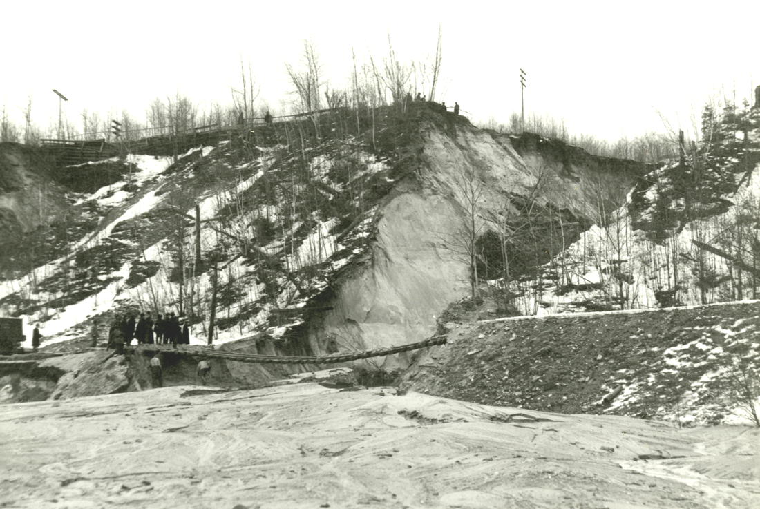
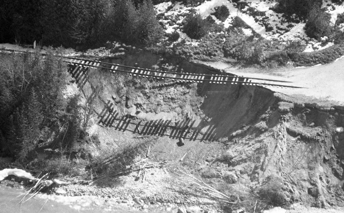
23 March 1913 ~ Washout West of Fairgrounds from one of the albums of Allan McCune located in the Little Traverse Historical Museum
1913 Photos Above and Below: Description of the washout from the 27 March 1913 Petoskey Evening News: "...the washout near the fair grounds, southwest of the city. As the trench dug there by the water is fully seventy feet deep and one thousand feet in length, it seems a stupendous task to fill in the cut and raise it to the road level."
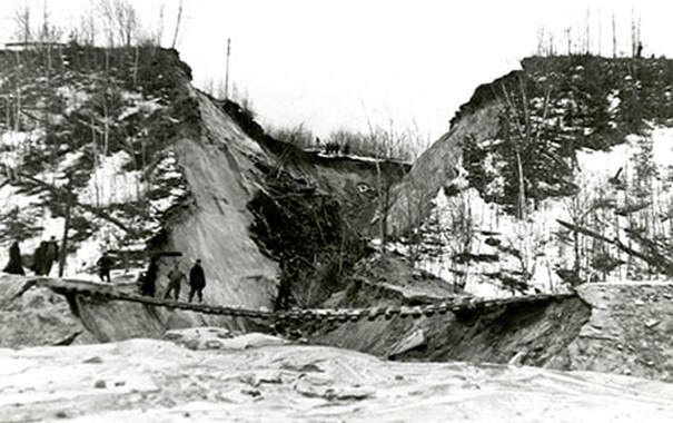
23 March 1913 ~ Washout West of Fairgrounds from one of the albums of Allan McCune located in the Little Traverse Historical Museum

27 March 1913 ~ The Petoskey Record
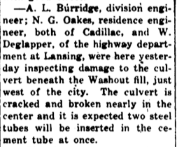
Article Above: Pere Marquette was not waiting for government to grind along; Pere Marquette was already, only four days after the washout, planning to construct a culvert to harness the destructive forces of Mother Nature... [see 1927 article below]
|

28 March 1913 ~ Petoskey Evening News.
|

14 August 1913 ~ The Petoskey Record
|
25 March 1913 ~ Petoskey Evening News AND 17 April 1913 ~ Pellston Journal
|
Article Left: Just days after the 1913 Washout, the "final shove" of the washout water lessened the 11 or 12 feet of fill needed under the free swinging railroad track by placing a large amount of sediment under the the track. Only 5 feet more of dirt was necessary to level the rails and ties.
24 April 1913 ~ The Petoskey Record
|
22 August 1913 ~ Petoskey Evening News

2 September 1913 ~ The Daily Record
Refer to article above: Jacob Grauel died 8 December 1919 on his farm south of Petoskey, just six years after filling the washout. He was a mason and contractor, and an employee of the Cement Plant on concrete construction work, and was buried in the Greenwood Cemetery; ALL very near the washout.
|
1916
Washed Out AGAIN!
Washed Out AGAIN!
29 March 1916 ~ Petoskey Evening News

10 May 1916 ~ Petoskey Evening News

11 June 1916 ~ Petoskey Evening News
2 April 1921 ~ Petoskey Evening News
Article Below: Is this the same culvert that had been written about in the 1913 article farther above?
The taxpayer can just pay again and AGAIN!
The taxpayer can just pay again and AGAIN!
24 February 1927 ~ Petoskey Evening News
1957
Washed Out AGAIN!
Washed Out AGAIN!
1957
2 July 1957 ~ Petoskey News Review
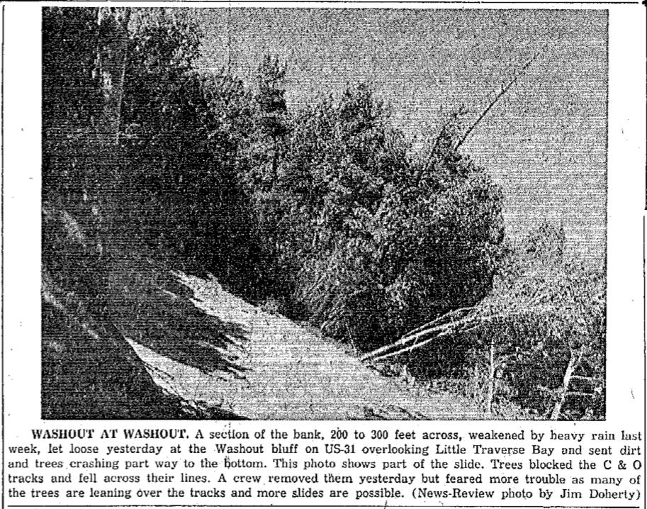
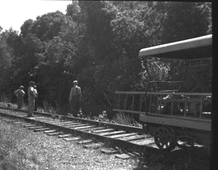
Photos Above and Below: Another washout in the same area occurred in 1957; by then the road name had been changed from Washout to Eppler Road, although Old Timers still referred to the road as WASHOUT. At that time trees blocked the C&O railroad tracks (rather than a wheelway).

Greenwood Photo Archive Collection from Petoskey Newspaper (July 1957)
|
Greenwood Photo Archive Collection from Petoskey Newspaper (July 1957)
|
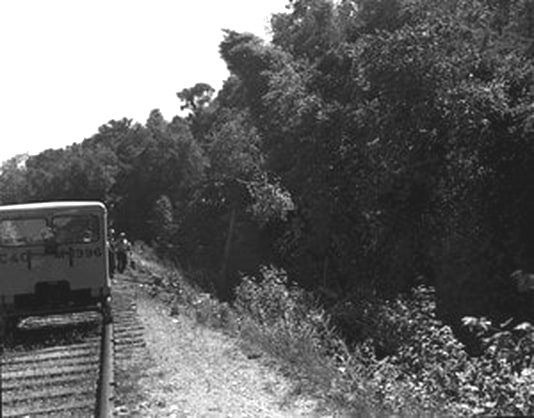
Greenwood Photo Archive Collection from Petoskey Newspaper (July 1957)
|
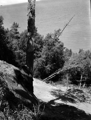
Greenwood Photo Archive Collection from Petoskey Newspaper (July 1957)
|
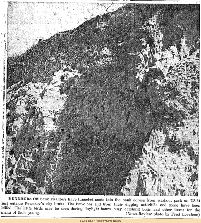
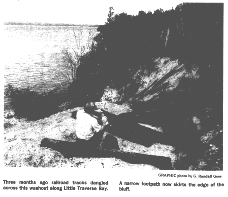
1959 Clipping Below: The Petoskey News Review also showed a similar instance in 1957 which may be accessed on the Flora and Fauna web page on this same web site by "clicking" HERE. Plain and simple, the slopes along this stretch of waterfront property are UNSTABLE when even a Bunch of Bank Swallow Birds can compromise the bank. Imagine placing a structure above this unstable slope, OR, placing a wheel way below the unstable slope.
"Washout Park" > Resort Bluff Park
(Considered for Carlos A. Weber Park)
(Considered for Carlos A. Weber Park)
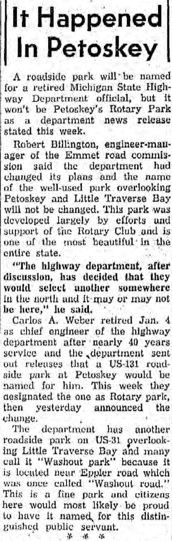
14 January 1960 ~ Petoskey News Review
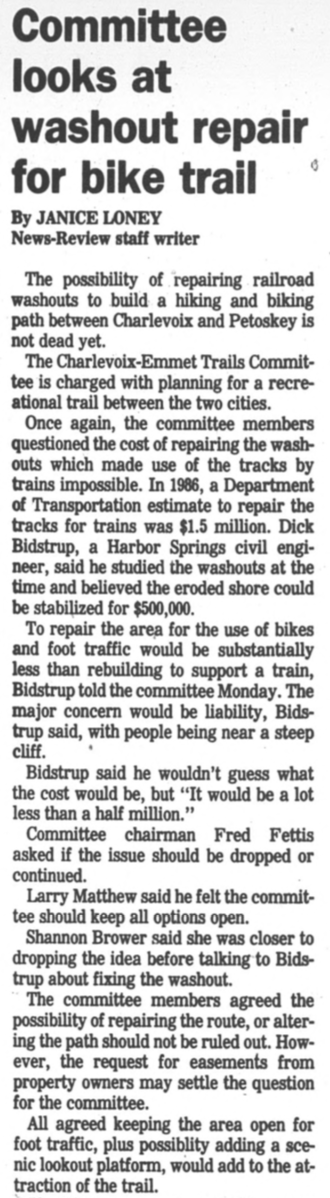
1985/86
Washed Out AGAIN!
Washed Out AGAIN!
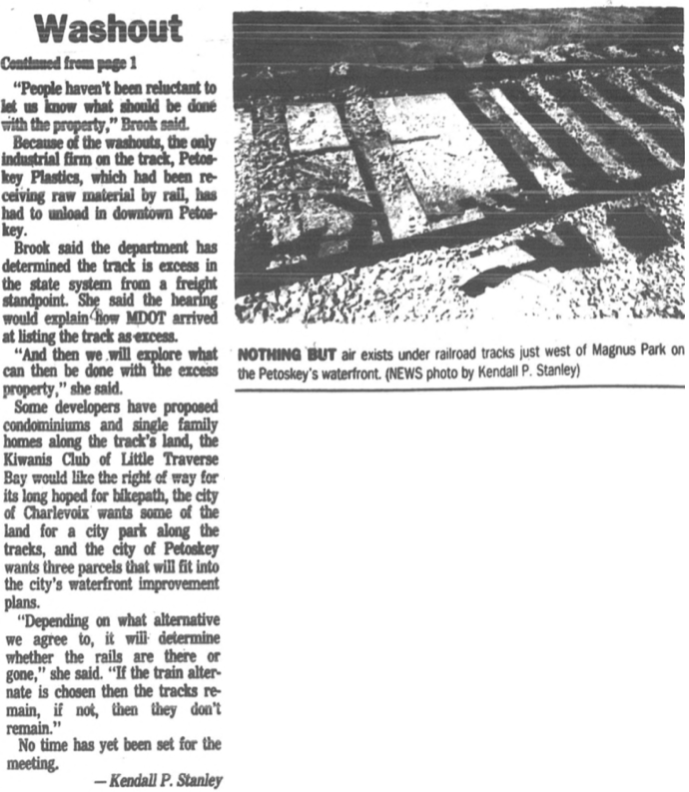
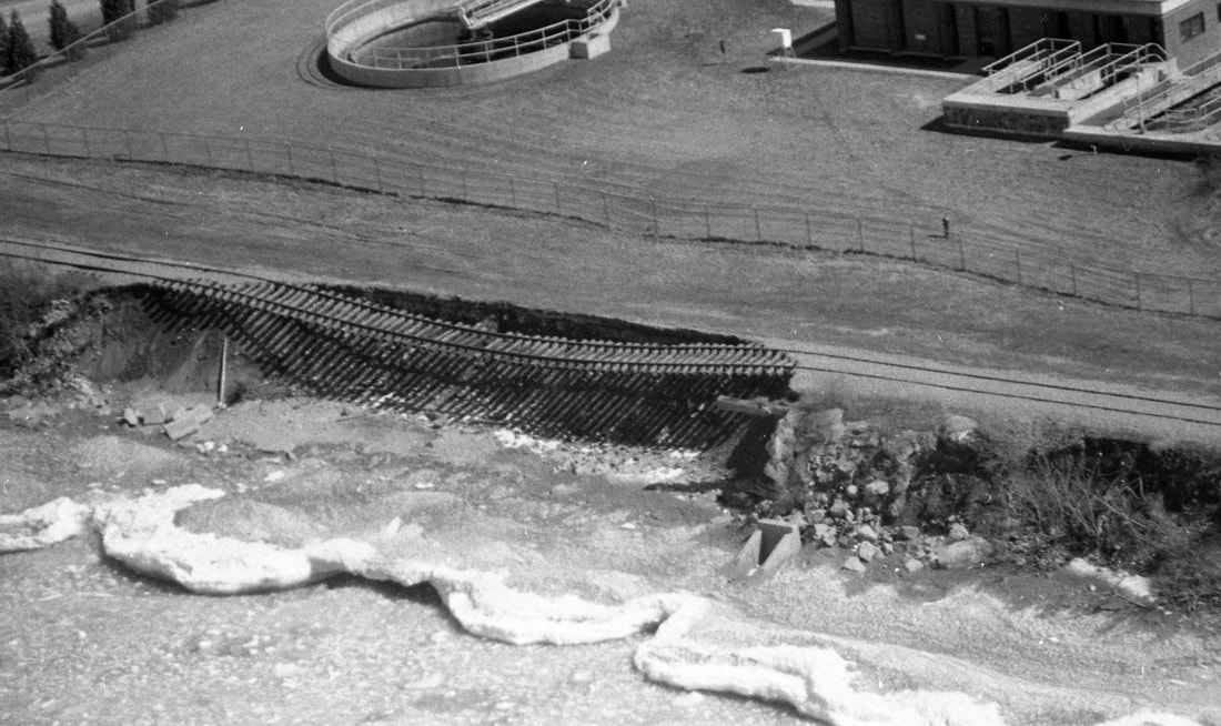
The map below from the Wetlands Web Page shows the wetlands and riverines. For orientation purposes… the red arrow points to the location of Petoskey Plastics Inc. which was built very near a riverine. The plant was built there for easy accessibility from the nearby railway to deliver product for the company. So, having built in a riverine location, is it a surprise that a 1985 storm washed out a section of rail line serving Petoskey Plastics? "The washout area was located below US 31 in an area that was inaccessible by road. Approximately 10 feet of track was suspended across the washout. Estimated cost of repair was $1 million, with no guarantees the repair work would not wash out." as reported in the 17 January 1986 Petoskey News Review below. Thus, MDOT declined to repair the railroad washout.
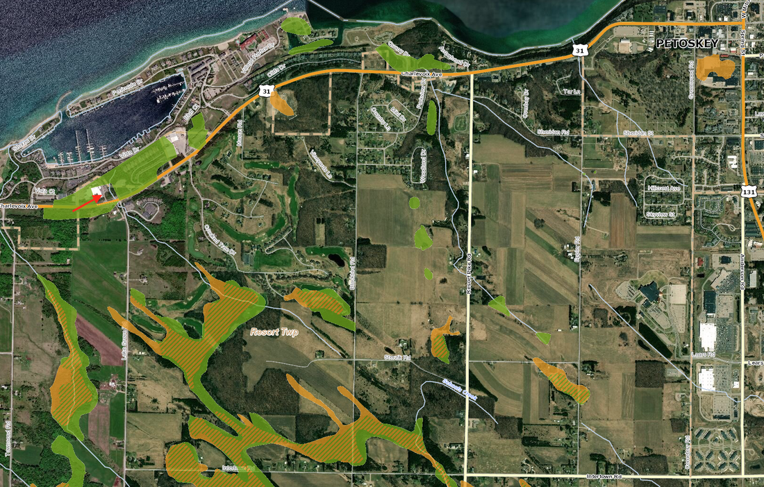
22 February 2020 ~ Map was created from the Wetlands Web Page showing Wetlands and Riverines

17 January 1986 ~ Petoskey News Review article continued below...
|
Petoskey Plastics received their plastic resin pellets by bulk tank rail car, but with the 1985 railroad track washout with no guarantee of track repair, their only solution was to immediately purchase a transfer tanker for $70,000.00. To this day in 2022, Petoskey Plastics receives their pellets from the still working railroad tracks with the Great Lakes Central train in the City of Petoskey, near the former old high school stadium... away from any riverine and/or washout area.
Petoskey Plastics did not wait for public assistance to buy a truck to be able to move forward as a company in 1986 after the washout. During the dreaded and feared Corona Virus, Petoskey Plastics set an example AGAIN, by not waiting for government "assistance," nor government "insistence" before moving forward to help the cause for the fight against the virus. The 1987 news article below shows that only a couple of years later (1987), Petoskey Plastics was flourishing due to their own ingenuity, and non-dependence on the government.
An Aside: The 24 March 2020 Petoskey News Review reported, "Over the past several days Petoskey Plastics, a manufacturing company based in Northern Michigan, has worked with McLaren Health Care to develop and approve a prototype for a hospital isolation gown. Petoskey Plastics received design approval on Friday and will begin manufacturing 10,000 gowns per day at its Petoskey plant to supply McLaren Health Care hospitals across the state of Michigan." |

17 January 1986 ~ Petoskey News Review article continued from above.
|

24 February 1987 ~ Petoskey News Review
Petoskey Plastics continues to be an amazing company. The 1 April 2021 Petoskey News Review reported that Petoskey Plastics will be adding a plant in McKinney, Texas... a suburb in the Dallas-Fort Worth area. In addition to Petoskey Plastics, Inc.'s Petoskey and Texas locations, the company has plants in Hartford City, Indiana, and Morristown, Tennessee. The corporate office is located at One Petoskey Street, Petoskey, Michigan. A sales office is in Birmingham, Michigan.

1 July 1986 ~ Petoskey News Review article continued below...
1 July 1986 ~ Petoskey News Review article continued from above...
|
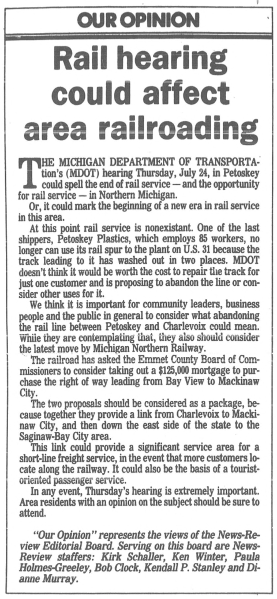
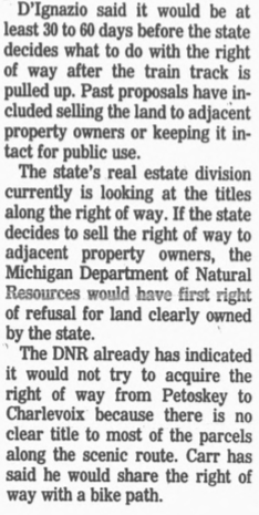
With Petoskey Plastics no longer able to use the washed out railroad track in 1986, the state was considering allowing the railroad rights of way to return to the property owners. Rail buff Bob Carr, however, had a dream and a steam locomotive, and only needed a track. The Michigan Department of Transportation held a public hearing to consider alternate uses for the rail lines and right of way. The 22 July 1986 Petoskey News Review reported, "His [Carr's] holdup at this point is two washouts on the rail line between Petoskey and Charlevoix and refinancing of the right-of-way between Petoskey and Mackinaw City by the Michigan Northern Railway." The 31 October 1986 Petoskey News Review quoted Sue Brook, head of MDOT's rail freight division. "In light of the fact our engineers have advised that one portion of the right of way should not be repaired because of danger of attempting to do so, if and when a private industry would want to, the state could have no tie to the property."
|
Editorial Below: The Petoskey News Review editorial gave a synopsis of what had transpired to reach the point of decision time. The editorial makes special note that: "At this point rail service is nonexistent. One of the last shippers, Petoskey Plastic, which employs 85 workers, no longer can use its rail spur to the plant on U.S. 31 because the track leading to it has washed out in two places. MDOT doesn't think it would be worth the cost to repair the track for just one customer and is proposing to abandon the line or consider other uses for it."
1986 and 1988
22 July 1986 ~ Petoskey News Review Editorial
|
The 16>22 July 1986 Harbor Light reported: "No service has been provided on the line since October of 1985, when high winds and storm waves on Little Traverse Bay eroded the shore line and caused the ground under a portion of the track to collapse.
'For safety reasons, rail service on the property was suspended immediately and has not been resumed,' said Ms. Norris [Michigan Department of Transportation's deputy director for Urban and Public Transportation]. 'After investigating the damage, MDOT's soils and slopes experts have determined there is no cost-effective way to stabilize the ground and restore the track.'" Article Below: The state was still giving consideration to the tourist train option before pulling up the tracks between Petoskey and Charlevoix; The state listed the property disposal alternatives.
26 April 1988 ~ Petoskey News Review (Part of the article)
|
Letter to the PNR Editor Below: Ironically, the letter calls attention to the washout area which was the ultimate demise of the proposed train ride tracks, AND the future wheelway.
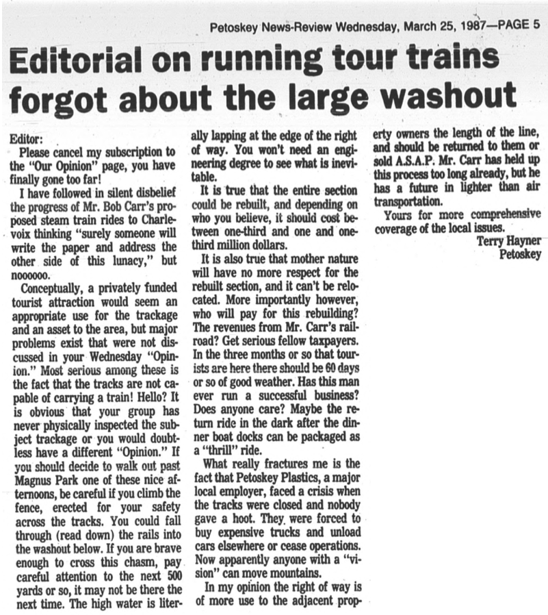
25 March 1987 ~ Petoskey News Review
Greenwood Photo Archive Collection from Petoskey newspapers (1987)
Greenwood Photo Archive Collection from Petoskey newspapers (1987)
Greenwood Photo Archive Collection from Petoskey newspapers (1987)
Photo Below: This is where the railroad track ran past the cement company... fairly close to the bay. No wonder any developer in the area would not want a bike path running through the center of prime resort development property; so the developer presented the trail council with land up closer to US-31, and just pulled this track... no chance for "rails to trails" through the heart of the Bay Harbor development.
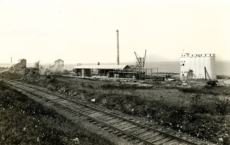
Little Traverse Historical Museum Photo Archive (Undated)
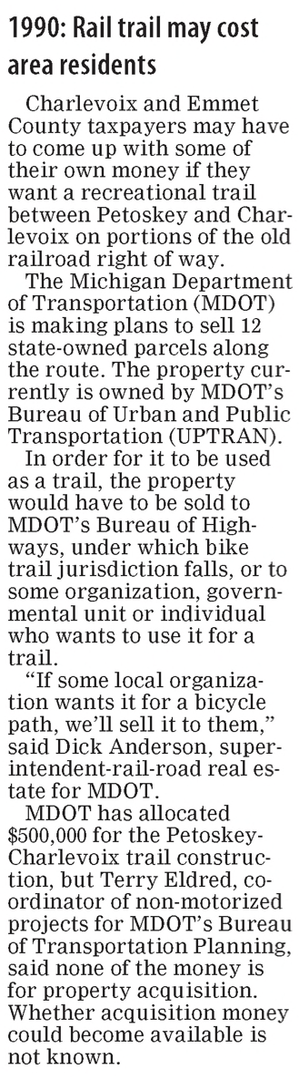
21 May 1990 ~ Petoskey News Review
The tracks between Charlevoix and Petoskey
were pulled up in July 1990.
11 October 1990 ~ The Graphic
23 October 1990 ~ Petoskey News Review article continued in column right...
|
23 October 1990 ~ Petoskey News Review article continued from column left...
|
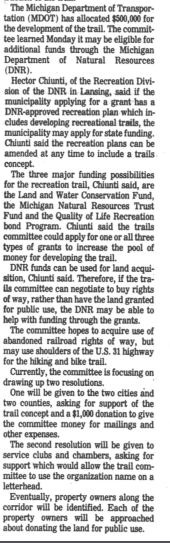
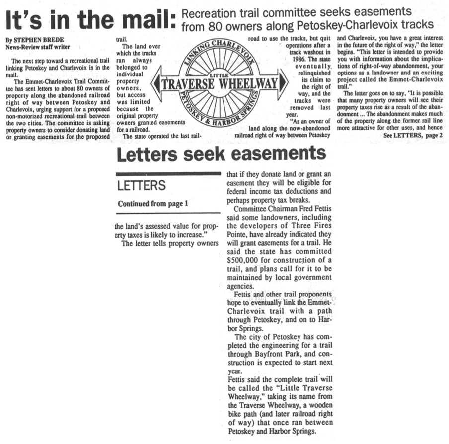
25 November 2015 ~ Petoskey News Review (Looking Back 25 Years)
Article Below: The Emmet-Charlevoix Trail Committee entices landowners by telling them "if they donate land or grant an easement [for a wheelway] they will be eligible for federal income tax deductions and perhaps property tax breaks." Three Fires Pointe development (later developed as Bay Harbor by David Johnson and CMS energy) would have found the pulling of the railroad tracks on their property away from the bayside area, and the connection of a wheelway highly desirable and very acceptable, especially with any monetary incentive.
24 October 1991 ~ Petoskey News Review
17 November 1991 Photo Below shows the old railroad grade along Little Traverse Bay's shoreline.
Greenwood Photo Archive Collection from Petoskey Newspaper (17 November 1991)
13 July 1992 ~ Petoskey News Review continued right column...
|
13 July 1992 ~ Petoskey News Review continued from left column...
|
1994
PRE Wheelway Shoreline Showing the Path of the Rails
PRE Wheelway Shoreline Showing the Path of the Rails

Greenwood Photo Archive Collection from Petoskey newspapers (1994)

Greenwood Photo Archive Collection from Petoskey newspapers (1994)
Photo Below: The PRE Wheelway Shoreline Showing the Path of the Rails is obvious
at the bottom of Eppler Road, near the Emmet County Fairground.
at the bottom of Eppler Road, near the Emmet County Fairground.
Greenwood Photo Archive Collection from Petoskey newspapers (1994)
26 April 1995 ~ Petoskey News Review
Read the 1995 article below to learn that MDOT funds (taxpayer dollars) were used to construct the rail to trail. So, who was the engineer who designed this segment over a riverine/wetland area? It was NDG... Northwest Design Group, now owned by OHM in 2020... still garnering tax dollars for valueless wheelway studies.
The BIG QUESTION IS: Why does Emmet County continue to pay for the results of incompetent and unsatisfactory engineering, design and workmanship in the county properties? Over and Over!
AND/OR
Could it be that some of the chosen site does not lend itself to the construction of a bike trail?
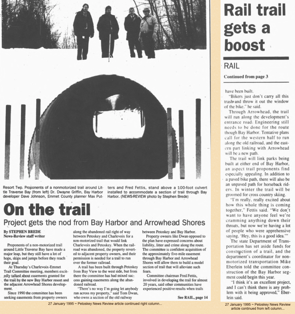
Article Above: It evidently PAID to be a 1995 "verbal holdout" about NOT allowing an easement across personal property for a Wheelway as Tom Dwan expressed. Eventually, even after Mr. Dwan had passed away in 1998, the county, on 17 March 2004, paid Tom Dwan's wife Mary Lou almost two million dollars [$1,899.000.00] for some of their bluff-side property. The article stated: "The money used to get the property will be paid from the tax revolving fund from the county account, which is funded when people pay back their delinquent taxes on property in the county." The entire issue of delinquent tax funds being used for purposes other than paying the proper entities like the schools, and townships, has continued to be an issue in the county... when finally a forensics auditor had to be hired to help the more recent commissioners try to rectify the improper use of delinquent tax funds. Ultimately, it is the taxpayer who PAYS no matter which pot of money is raided.
12 November 1999 ~ Petoskey News Review
|
Article Below: Transaction happened in 1928...
16 October 1978 ~ Petoskey News Review (50 Years Ago Article)
|
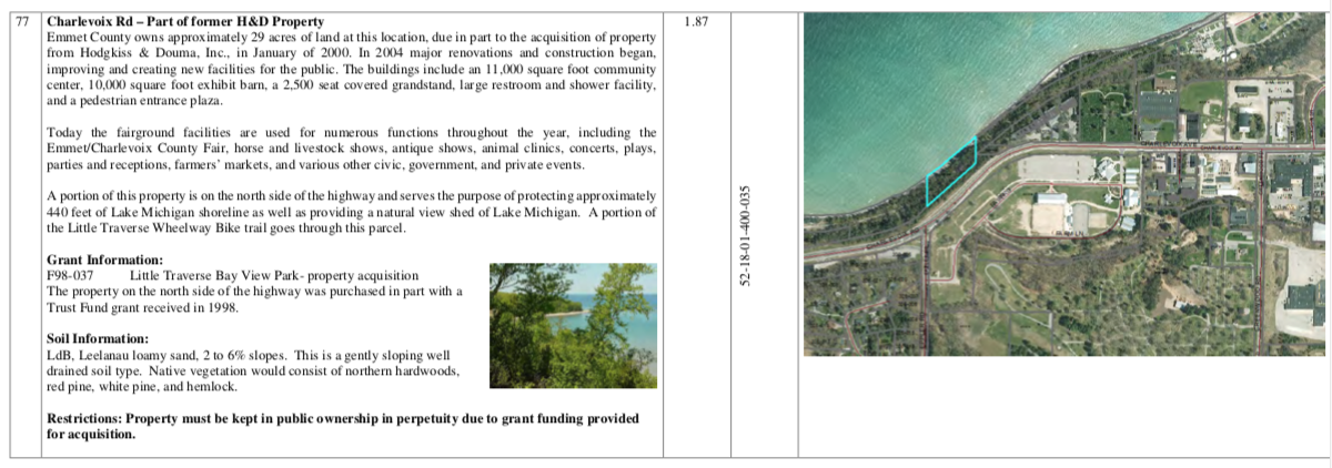
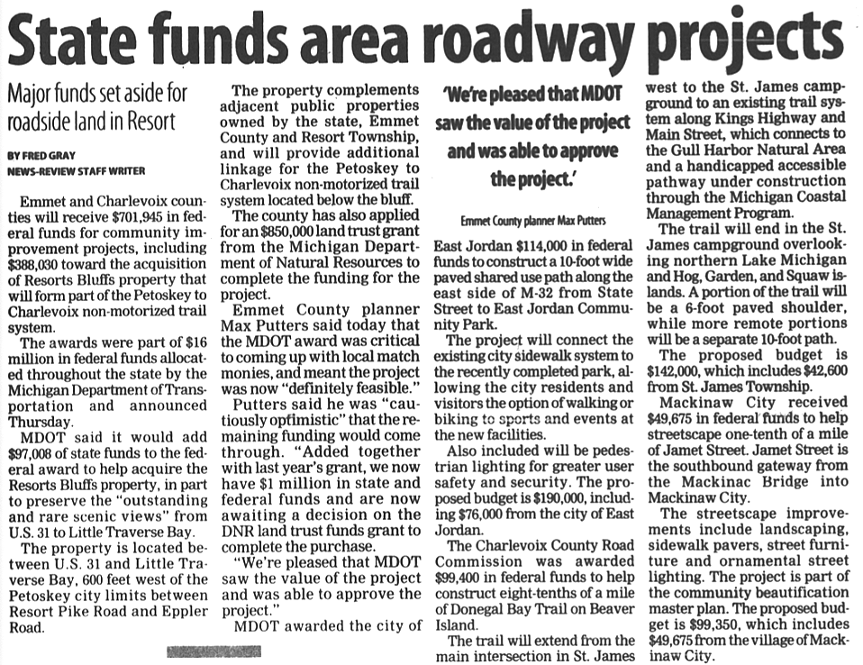
Article Above: In the meantime, on 7 January 2000 Emmet County acquired on the north side of US 31, across from the Emmet County Fairgrounds, 440 feet of Lake Michigan shoreline where a portion of the Little Traverse Wheelway Bike trail goes through the parcel. This bluff-side parcel, along with the fairgrounds acreage for a total of about 29 acres of land was purchased from Hodgkiss Trust for $800,000.00 through state grants and a manipulation of county funds, partially using "tax revolving funds." See additional information about this Hodgkiss Trust property purchase on the "Fairgrounds" web page on this Northern Mich~Mash Preserve web site by clicking HERE.
Below: Public property records on Emmet County's "Property Search" show that on 7 January 2000 Emmet County acquired property [Parcel Number 52-18-01-400-035] 440 feet of Lake Michigan shoreline, a split off the fair property with the total land price being $800,000.00. Notice the Soil Type: "This is a gently sloping well drained soil type" with no mention of erosion. |
Directly next to the above described "gently sloping well drained soil type" the Pine Bluff Townhouses were built. The two 2 July 1979 photos below give a description of the townhouse locations related to the water below as "135 feet above the water" AND "The townhouses sit high above the Lake Michigan waters, with a steep incline for a backyard, but a pair of stairways totaling 127 steps lead to the beach."
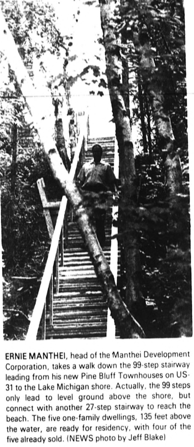
2 July 1979 ~ Petoskey News Review
|
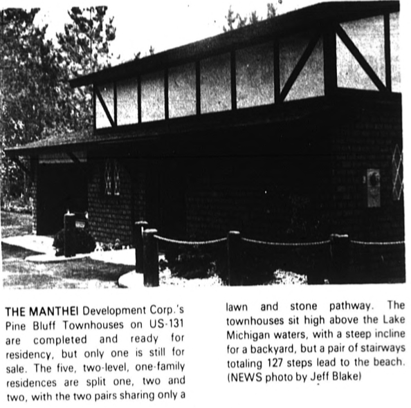
2 July 1979 ~ Petoskey News Review
|
7 March 2002 ~ Petoskey News Review
31 May 2002 ~ Petoskey News Review
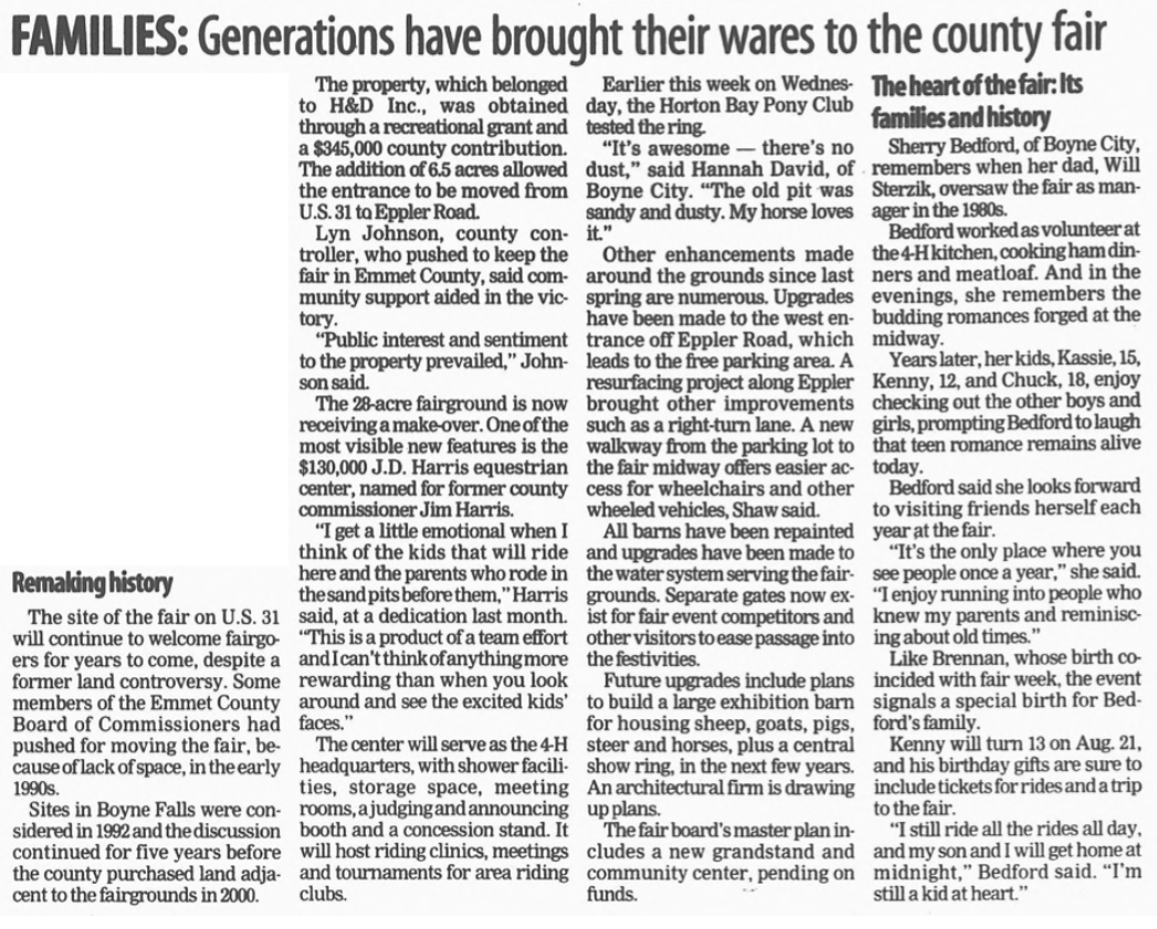
Article Below: Interesting how this H&D Inc. property is presented as the addition of 6.5 acres allowing the entrance to the fairgrounds to be moved from US 31 to Eppler Road... which was definitely a good move; paid through a recreational grant PLUS $345,000.00 county (taxpayer) dollars. The H&D Inc. property purchase was definitely in the plans to be a portion of the wheelway acquisitions.
16 August 2002 ~ Petoskey News Review
24 October 2002 ~ Petoskey News Review
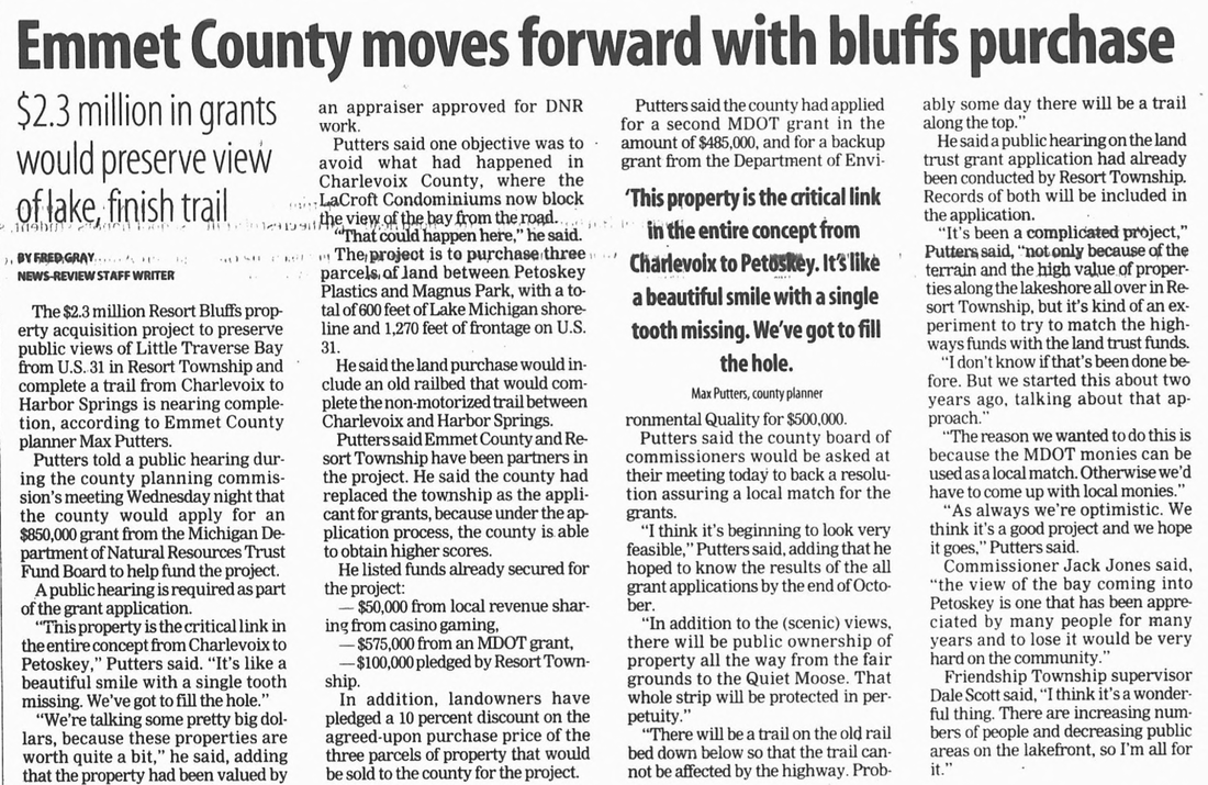
In the November 2002 news article below even before the unfinished section of wheelway was possible, due to lack of land ownership in the Resort Bluff area, Emmet County's controller Lyn Johnson was pondering how the county should pay for a maintenance crew for the M-119 section of wheelway which was already finished. He did state that the county was responsible for the section on M-119, but the article did not say where that decree was documented or recorded, other than Johnson saying it. Then County Planner Max Putters stated interesting comments: "There is a gray area here [regarding repair/reconstruct responsibility]. We were always told we would not have to rebuild an area. If it has deteriorated, I would question whether it was properly put down in the first place" ..." The trail is too new for this. It was built to last 15-20 years. But I think MDOT's position is, 'We gave you the money for it and now you take care of it.'" Now, in 2020, only 12 to 14 years from construction of the Resort Bluff wheelway area, the wheelway is eroding/deteriorating; the city and Resort Township are expecting the county to pay toward a STUDY for the area of Resort Bluff, which is an area on the Wheelway map as designated to the city. Not only does the map show that, but the specific grant easements for the parcels of Resort Bluff parcels of land states that it will be up to the Grantee (the City of Petoskey) to pay for repair of the trail!
21 November 2002 ~ Petoskey News Review article continued below maps...
Posted as a public record in the packet for the Emmet County Board of Commissioners' 20 February 2020 Committee of the Whole meeting... and appears to be the same map as printed below in the 2002 news article shown above and below...
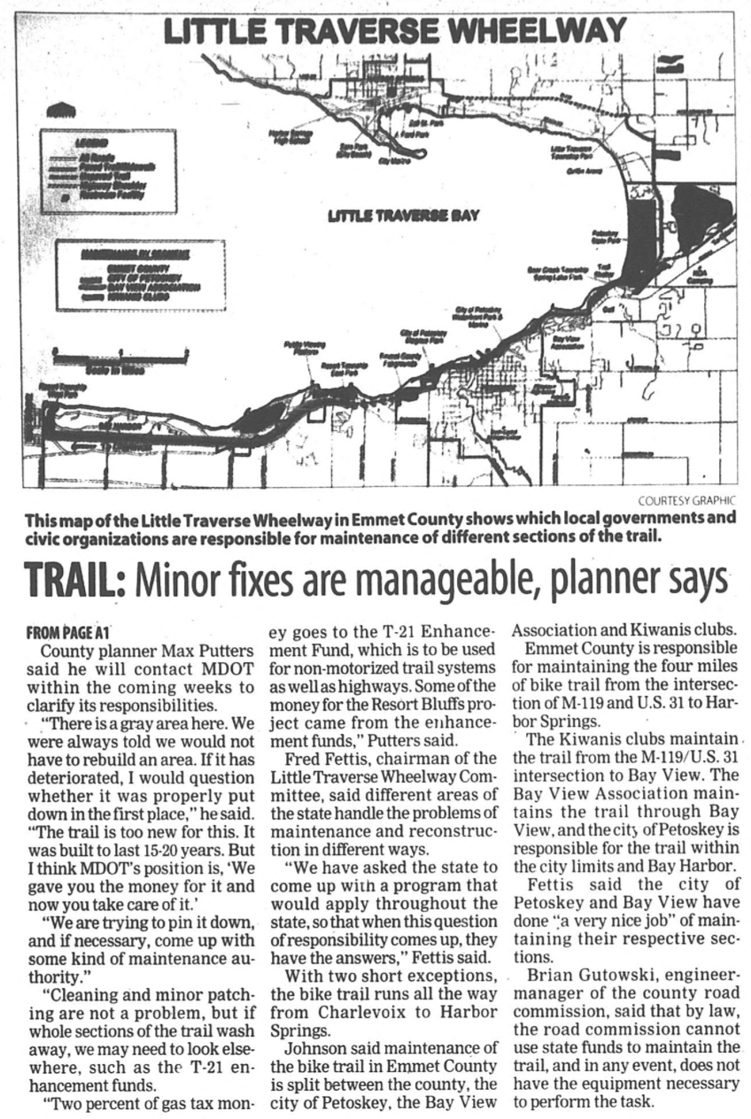
21 November 2002 ~ Petoskey News Review article continued from above...

23 January 2003 ~ Petoskey News Review
28 March 2003 ~ Petoskey News Review
|
10 December 2003 ~ Petoskey News Review
In the 10 December 2003 Petoskey News Review it was reported that "A proposal to help fund land acquisition for a recreation trail between Petoskey and Bay Harbor ended in a deadlock among Resort Township board members Tuesday." ... "the board discussed the possibility of turning the $50,000 grant [Emmet County Local Revenue Sharing Board money] and an equal portion of township funds over to county officials to help with the land purchase. As Resort trustee Bob Nicol owns some of the land targeted for purchase, he abstained from the discussion and voting on the matter to avoid a conflict of interest."
|
29 December 2003 ~ Petoskey News Review
|
18 March 2004 Article Below: "Dwan and the Nicols were first approached about selling the land along U.S. 31 between Eppler and Resort Pike roads for public trails use FOUR years ago." That statement is not true. Look at the 27 January 1995 article above where Tom Dwan was, to the Dwan Family's advantage (definitely not to the taxpayers' advantage), a holdout for selling his property, not FOUR years, but rather for NINE years.
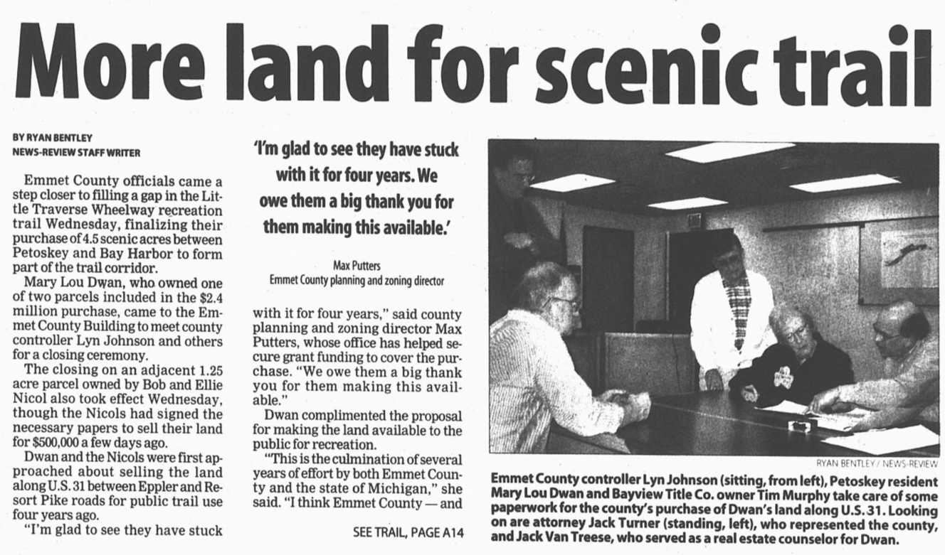
18 March 2004 ~ Petoskey News Review article continued below...
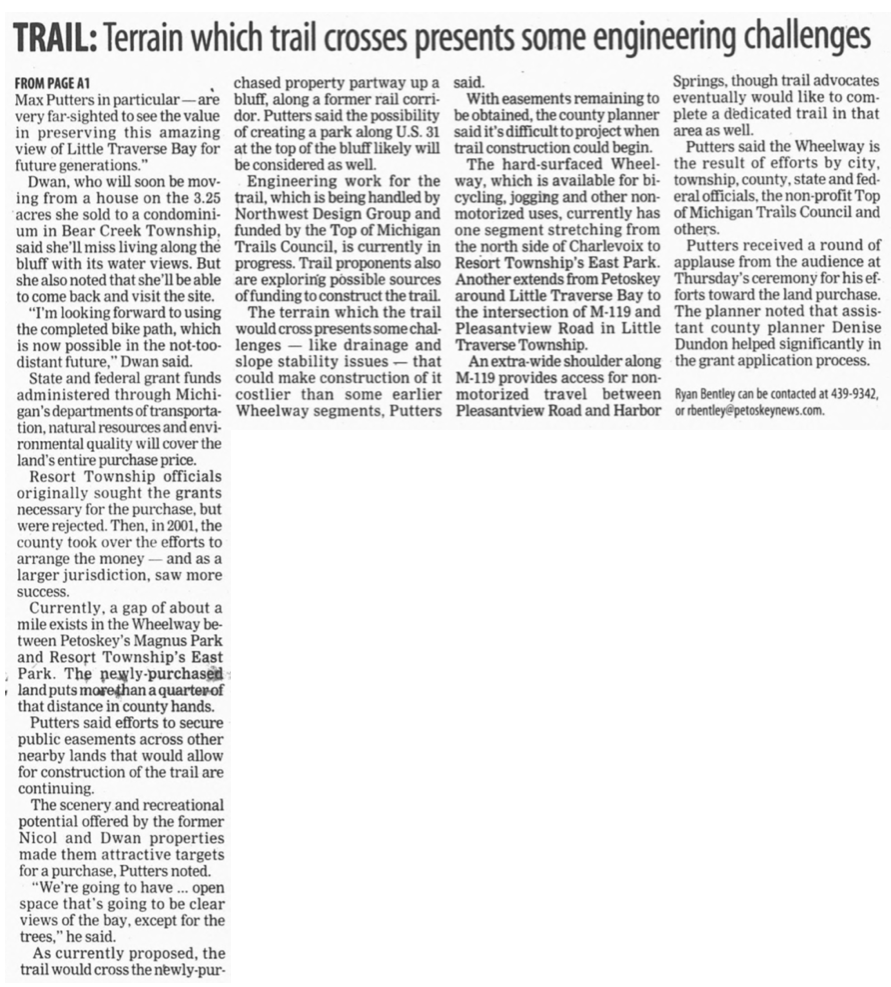
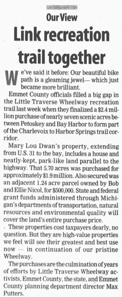
The continued 2004 article below notes: "Engineering work for the trail, which is being handled by Northwest Design Group and funded by the Top of Michigan Trails Council, is currently in progress. Trail proponents also are exploring possible sources of funding to construct the trail. The terrain which the trail would cross presents some challenges–like drainage and slope stability issues–that could make construction of it costlier than some earlier Wheelway segments, Putters said."
So, one has to wonder WHY recently on 20 February 2020 that City of Petoskey governmental officials stated the erosion situation was "urgent" so possibly MILLIONS of more dollars will be needed in the future to restore the eroding Wheelway. How did the erosion suddenly become urgent when as Max Putters stated in the 2004 article below that the slope stability was being questioned. No mention was made of "high water levels" in the bay creating the unstable bluff, like the reason of "high water levels" being brought forth in 2020. BUT, in 2020, no mention to the taxpayers is being made of the KNOWN of historical instability of the bluff.
So, one has to wonder WHY recently on 20 February 2020 that City of Petoskey governmental officials stated the erosion situation was "urgent" so possibly MILLIONS of more dollars will be needed in the future to restore the eroding Wheelway. How did the erosion suddenly become urgent when as Max Putters stated in the 2004 article below that the slope stability was being questioned. No mention was made of "high water levels" in the bay creating the unstable bluff, like the reason of "high water levels" being brought forth in 2020. BUT, in 2020, no mention to the taxpayers is being made of the KNOWN of historical instability of the bluff.
18 March 2004 ~ Petoskey News Review article continued from above...
14 May 2004 ~ Petoskey News Review
|
Article Left: Putters again was stating "With steep slopes to stabilize, terrain that will likely prove challenging for construction and drainage issues to resolve, the 'Resort Bluffs' segment between Petoskey and Bay Harbor will likely be one of the more expensive stretches of Wheelway to complete."
So it was not as if Putters, or anyone connected with the proposed wheelway, was unaware of the EXISTING possible slope failures in that particular area. Northwest Design Group was doing the engineering for up to $190,000.00 to be paid by the City. What did the engineers plan for addressing the existing possible slope failure issue? Obviously, NOTHING. By 2020, that very location was a total washout! |
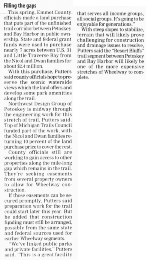
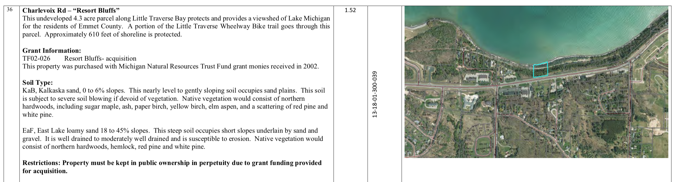
Resort Bluff is on Emmet County Property located along Charlevoix Avenue, US 31. The land was purchased through grants, along with the Michigan Natural Resources Trust Fund ($869,400.00), from the property owners at the time (Dwan & Nicol).
Below: Public property records on Emmet County's "Property Search" show that on 9 March 2004 Robert & Mary Ellen Nicol sold their property [Parcel Number 13-18-01-300-039] to Emmet County for $506,000.00. Notice the Soil Type: "It is well drained to moderately well drained and is susceptible to erosion."
Below: Public property records on Emmet County's "Property Search" show that on 9 March 2004 Robert & Mary Ellen Nicol sold their property [Parcel Number 13-18-01-300-039] to Emmet County for $506,000.00. Notice the Soil Type: "It is well drained to moderately well drained and is susceptible to erosion."
Public property records on Emmet County's "Property Search"
Below: Public property records on Emmet County's "Property Search" show that Mary Lou Dwan sold her property [Parcel Number 13-18-01-300-003] to Emmet County on 17 March 2004 for $1,899,000.000. Notice the Soil Type: "It is well drained to moderately well drained and is susceptible to erosion."

Public property records on Emmet County's "Property Search"
Below: On the same 17 March 2004 date as the county purchase above, Emmet County acquired a long roadside piece of property [Parcel Number 13-18-01-300-002] which does not access the water's edge, for an undisclosed sum also from Mary Lou Dwan. This piece has no extra descriptions listed on property summary as shown below. On the legal description for this property it is called Resort Bluffs Park. The comment states that on L1048 P636 is a Declaration of Use.
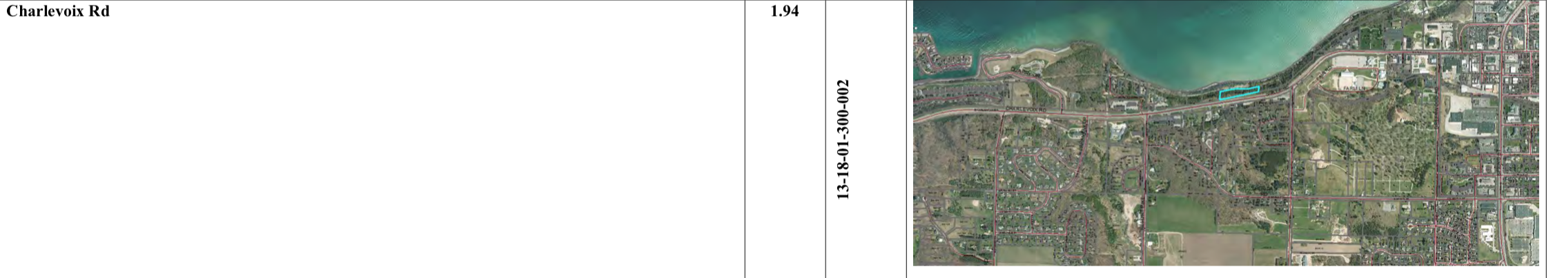
Public property records on Emmet County's "Property Search"
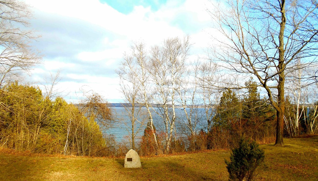
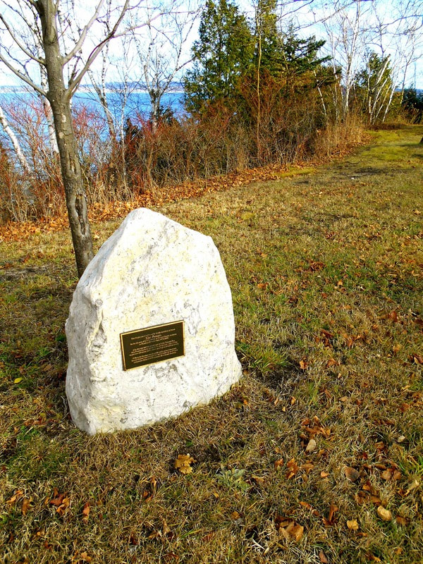
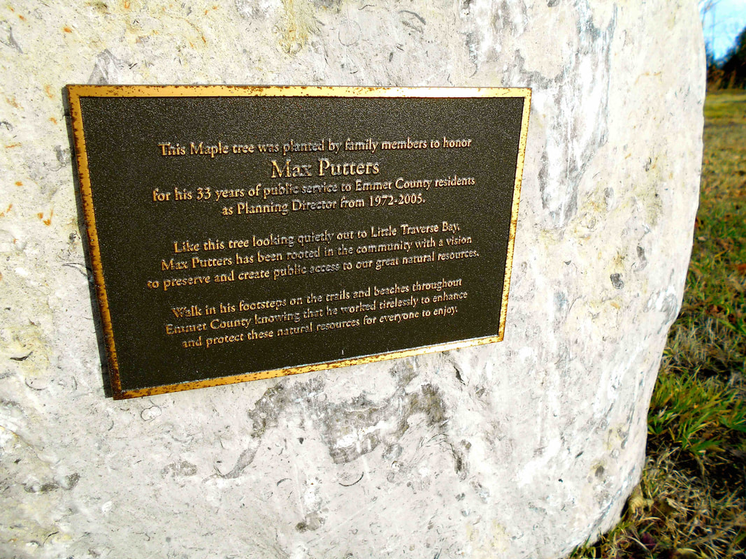
Plaques have been installed on boulders sitting on the property (purchased with the wheelway in mind)
which has a severe cliff on the bay side of the property with warning signs.
Interestingly, names on the plaques are those closely associated with the sale/purchase of the land...
Putters and Dwan
which has a severe cliff on the bay side of the property with warning signs.
Interestingly, names on the plaques are those closely associated with the sale/purchase of the land...
Putters and Dwan
29 November 2017
Two Photos Below: The plaque states Max Putters "worked tirelessly" to complete the Little Traverse Wheelway which runs below the bluff; often mentioning the challenges with the drainage and instability of the bluff issues... never heeding his own "danger signs." The plaque states: "This Maple tree was planted by family members to honor Max Putters for his 33 years of public service to Emmet County residents as Planning Director from 1972-2005. Like this tree looking quietly out to Little Traverse Bay, Max Putters has been rooted in the community with a vision to preserve and create public access to our great natural resources. Walk in his footsteps on the trails and beaches throughout Emmet County knowing that he worked tirelessly to enhance and protect these natural resources for everyone to enjoy."
29 November 2017
|
29 November 2017
|

29 November 2017 ( white "WARNING sign")
Two Photos Below: "Thomas Arthur Dwan FI US Navy World War II Jun 28 1926 ~ Aug 25 1998" AND "Sara E. Dwan February 3, 1960 ~ November 10, 2001 Gone But Not Forgotten"
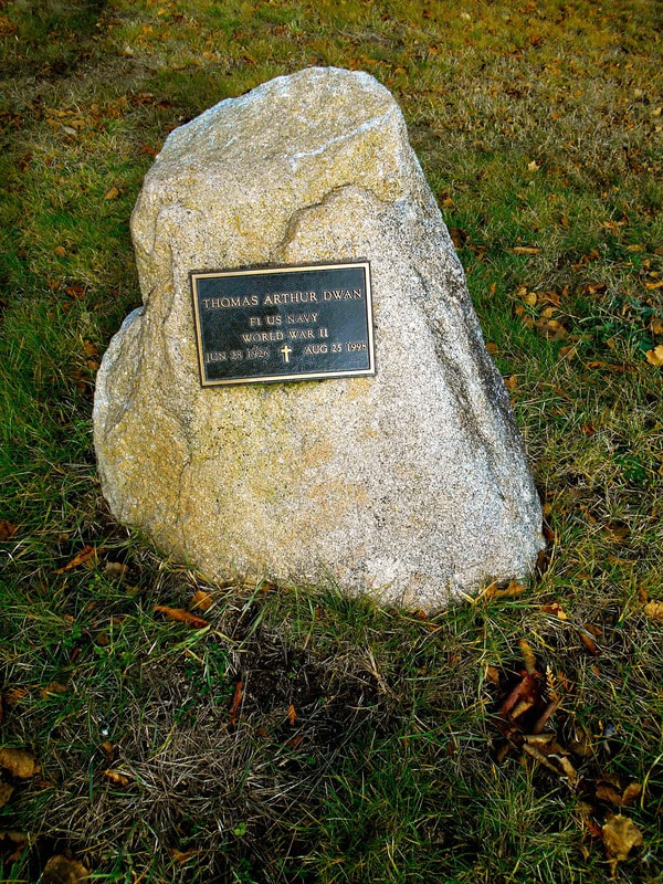
29 November 2017
|
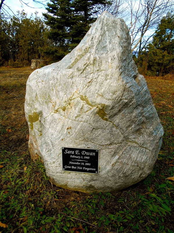
29 November 2017
|
2004 Petoskey News Review Editorial Below: "Engineering work for the trail, which is being handled by Northwest Design Group and funded by the Top of Michigan Trails Council, is in progress. But it won't come cheap. The terrain which the trail crosses is difficult in places and includes cliffs and washout problems which must be surmounted." Even the Petoskey News Review Editorial staff was acknowledging the "washout" setting of the recently purchased land, but wheelway promoters just pushed forward, with no guarantee from the Design Group... was any actual engineering done? Various factions just seemed to do "whatever" to garner an amount from the taxpayers to make the wheelway happen, and to heck with what was destined to happen "down the way".... factions not caring how many times the taxpayers are expected to pay for the same results of incompetent and unsatisfactory studies, engineering, design and workmanship in the county properties? Over and Over!
25 March 2004 ~ Petoskey News Review Editorial continued column right...
|
25 March 2004 ~ Petoskey News Review Editorial continued from column left...
|
Editorial Above: Did the county's purchase of the Dwan's property actually include a house?
The answer to this question was provided in the 11 January 2022 obituary of Mary Lou Dwan when it revealed: Mary Lou's husband Tom had built a bay house on Charlevoix Avenue overlooking the Little Traverse Bay. "The bay house was moved to the Headlands International Dark Sky Park, where it became the park caretaker's residence."
The answer to this question was provided in the 11 January 2022 obituary of Mary Lou Dwan when it revealed: Mary Lou's husband Tom had built a bay house on Charlevoix Avenue overlooking the Little Traverse Bay. "The bay house was moved to the Headlands International Dark Sky Park, where it became the park caretaker's residence."
On 23 May 2006 Emmet County, to eliminate the last hold-out for the possible easement of land for the Wheelway, purchased property at 2684 Charlevoix Road, Petoskey, Michigan, for $600,000.00 from Douglas A. Horace; thus still referred to as the Horace Property with its own history. The highly unusual 11 October 2018 sale of this Horace property is chronicled closer to the top of this same web page. Thus, the county no longer owns this property, nor has any responsibility whatsoever, regarding this property.
Regarding properties the county does still own in 2020 in the same area as the Horace Property, the records of all four documents granted the easements (to be executed on 8 February 2008) that exist for county properties ending in 002,003,035, and 039 between the County of Emmet (Grantor), to the City of Petoskey (Grantee), noting the same responsibilities of maintenance of the city (NOT the county) in each recorded "Easement for Non-Motorized Trail: as follows:

Photo/Text Below: Already in 2008 a wheelway area between Petoskey and Bay Harbor was labeled as
"a washout-prone section."
"a washout-prone section."
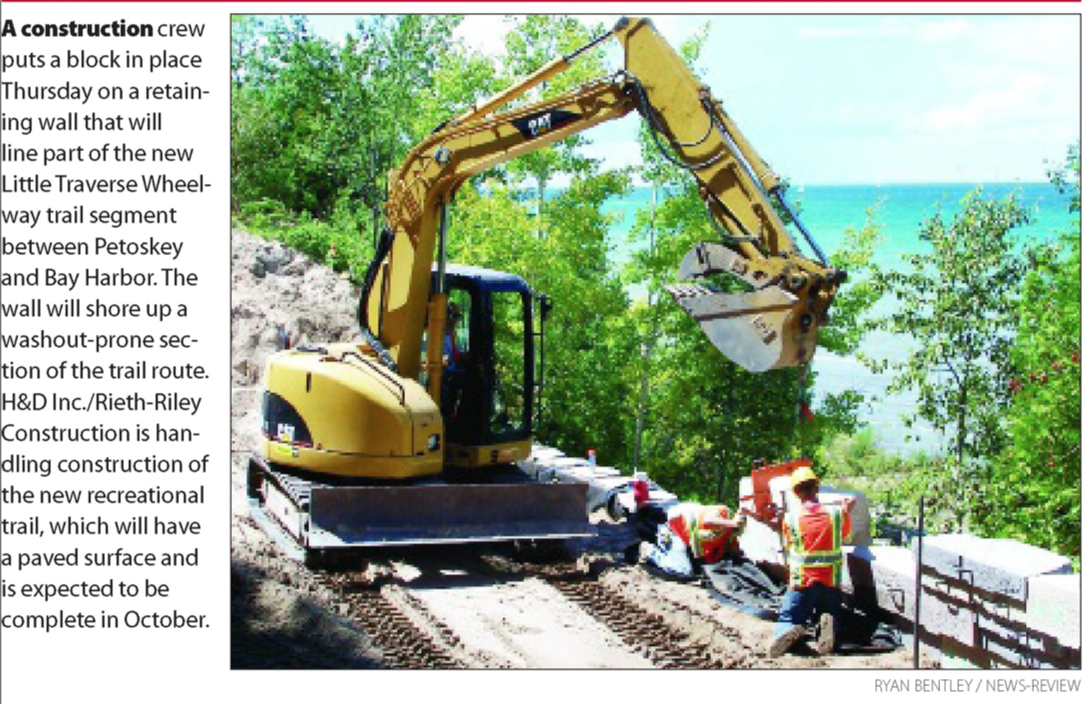
8-10 August 2008 ~ Petoskey News Review
Photos Below: Putting through the Pere Marquette Railroad tracks on a bed of sand...
The rail that went to trail! Tracks to Wheelway!
The rail that went to trail! Tracks to Wheelway!
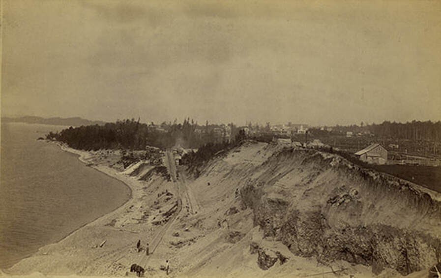
Photo Below: Fairground steps lead to the Pere Marquette Railway track in the nearby area shown in the text/photos above and below...
(the steep slopes appear to be from sand dunes, not from lime stone in this area... prone to erosion)
(the steep slopes appear to be from sand dunes, not from lime stone in this area... prone to erosion)
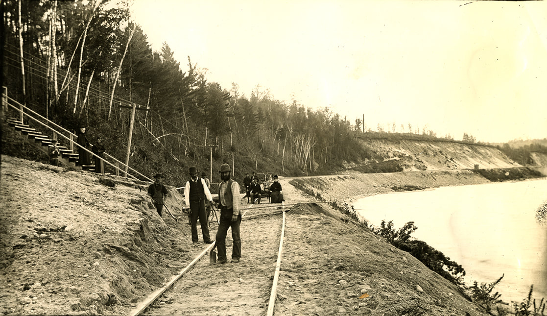
Allan McCune a successful Petoskey businessman and local historian donated several of his albums to Petoskey's Little Traverse Historical Museum. One of his albums included this copied photo labeled as "Fairground Steps on Pere Marquette Railway"
Photos Above and in the news article Below: The locations in the two photos are very similar in location.
8 October 2008 ~ Petoskey News Review
|
7 November 2008 ~ Petoskey News Review
|
The 2008 Petoskey News Review article below left lists the MANY support groups for the Wheelway Link Work.
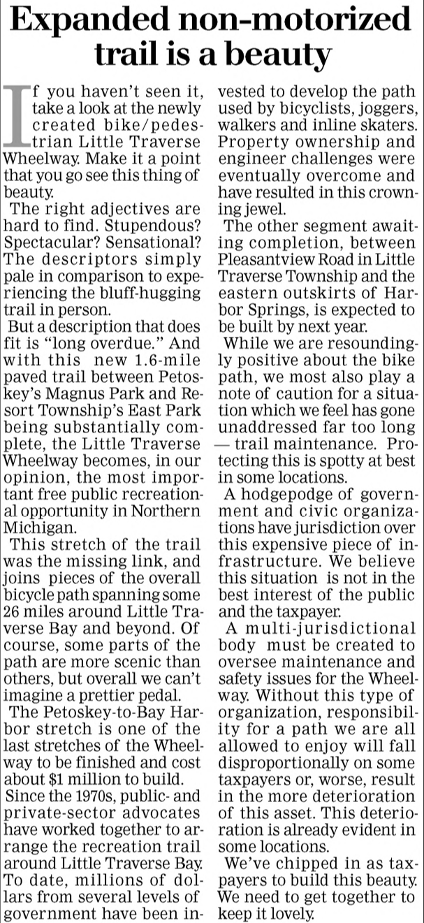
The 2008 Petoskey News Review article below right talks not only about the beauty of the trail, but read the next to the last paragraph. It tells that "A multi-jurisdictional body must be created to oversee maintenance and safety issues for the Wheelway. Without this type of organization, responsibility for a path we are all allowed to enjoy will fall disproportionately on some taxpayers or, worse, result in more deterioration of this asset. This deterioration is already evident in some locations."
The 2008 Petoskey News Review article below right talks not only about the beauty of the trail, but read the next to the last paragraph. It tells that "A multi-jurisdictional body must be created to oversee maintenance and safety issues for the Wheelway. Without this type of organization, responsibility for a path we are all allowed to enjoy will fall disproportionately on some taxpayers or, worse, result in more deterioration of this asset. This deterioration is already evident in some locations."
5 June 2008 ~ Petoskey News Review
|
18 November 2008 ~ Petoskey News Review
|
TOP
The Petoskey Breakwall, during a 2006 storm which knocked out a 50 foot gap from the barrier, was finally being repaired in 2009, using the services of Roen Salvage Co. of Wisconsin. Click HERE for additional information about this event and the Petoskey waterfront. One would have thought that the forceful 2006 storm damaging waterfront property would have been heeded when designing/engineering the Little Traverse Wheelway. At that same time, a weather bouy was to be installed... has that gathered information ever been accessed, or was it of value, or ignored, in further decision making for the wheelway?
7 July 2009 ~ Petoskey News Review
The 2013 article below is illustrative of the 2020 fallacy that the Great Lakes' HIGH waters need to be fixed! Any type development near the water must prepare, through design and engineering, for the extremes of both the "HIGHS" and the "LOWS" of the water levels... not just one cycle of water level.
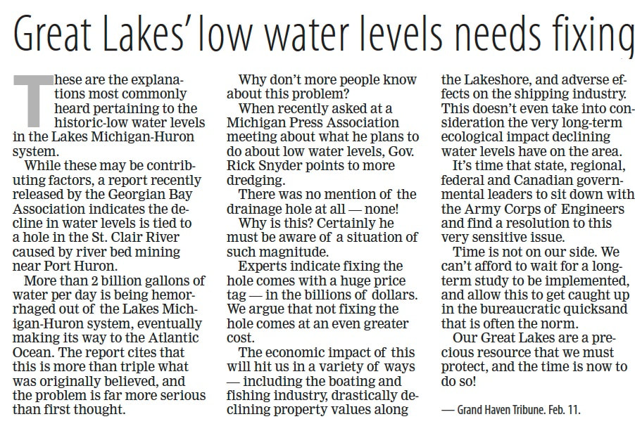
19 February 2013 ~ Petoskey News Review
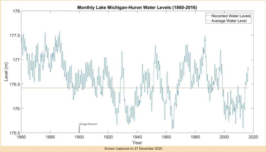
Graph Below: Access to the "Monthly Lake Michigan-Huron Water Levels (1860-2016) as shown below, plus other water level information may be accessed by clicking HERE.
19 May 2021 ~ Petoskey News Review
I appreciate how many wonderful organizations, and even private individuals, have promoted the Little Traverse Wheelway. The Wheelway also can be appreciated by the number of businesses who have profited from the influx of tourists who enjoy the wheelway. The local economy has benefited from the wheelway. Not just money-wise gains, but pure enjoyment of the experience of using the wheelway is immense to many.
Since the 1980s, the county taxpayers have certainly paid their share with making public property deeds with easements possible and available, although most not free. Remember grants are not FREE money. The county, through grants and various other means, purchased the Horace Property for $600,000; Purchased the Nicol and Dwan properties for about $2.5 million; purchased the Hodgkiss Trust bluff-side property across from the fairgrounds. All of these investments occurred during times when the county properties, as well as other properties near the wheelway between Petoskey and East Park in Resort Township, espoused the known “instability of the bluff” as noted in various articles/records. Wetland maps show wetland areas and riverines running right toward, and through, the wheelway. Those areas witnessed highly destructive land masses and railroad track wash outs in 1912, 1913, 1916, 1957, and 1985-86. The 1986 washout of the RR tracks then located beside US 31 and Lake Grove Road caused Petoskey Plastics to buy a then $70,000 loading truck for their pellets so they could use the other inland train tracks that still, in 2022, exist behind the old high school stadium on Standish Avenue.
If groups, individuals, businesses, feel that it is to their advantage to continue the wheelway in the erosion prone areas, then let them figure out how to fund it AGAIN, AND to make it safe… perhaps not near an erosion prone cliff which has never been a secret. County taxpayers must ask, how many times do the commissioners representing taxpayers have to be "hit in their heads, and hit in the county coffers," with payments for the results of incompetent design, and engineering. If necessary, find a qualified engineer who is willing to sign for a guarantee on the design. That likelihood of engineers guaranteeing their work for that slope instability setting is probably not possible.
Look at the historical facts as posted on this web page declaring this part of the wheelway is a fragile area with questionable slope stability. Money ($81,000.00 +) does not have to be spent on a STUDY to figure that out... but that $81,000.00 was paid for nothing more than a STUDY.
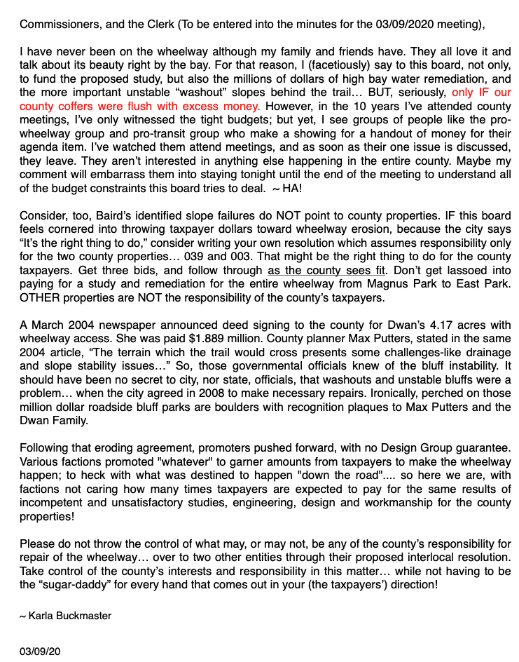
~ Karla Buckmaster (February 2020)
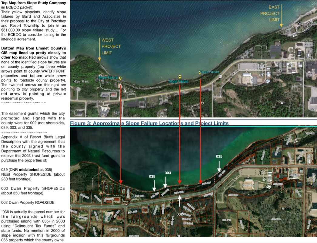
On 9 March 2020 at the Emmet County Board of Commissioners' meeting, an interlocal resolution for Emmet County joining Resort Township and the City of Petoskey was presented for paying $81,000.00 to be divided three ways... for a study of the slope failure of the Wheelway between East Park and Magnus Park (calling that the Project Limit). The top map below was presented in W.F. Baird & Associates Ltd.'s proposal to study the slope failure. The GIS map directly below with the marking arrows between the two, shows that so far, NONE of the slope failures are identified on county owned property.
The ECBOC, however, resolved to enter into the joint STUDY (change all of the words "project" to "study"), up to only one-third of the cost, and no more. The ECBOC Chairman also required that the STUDY include, not only the high bay water in front of the wheelway be studied, but also the waters (could be wetlands and riverines) behind the the wheelway be included in the study [This never was included]. The city manager agreed to all of the county's requests. The board room was FILLED with wheelway supporters with most of them quickly leaving after their agenda item... not being interested in anything else happening in the entire county (see below public comment at the beginning of the 9 March 2020 ECBOC meeting regarding "taxpayer handout syndrome"). UPDATE: MOST of the wheelway supporters did leave before the meeting was over. FURTHER UPDATE: The study report did not include any wetlands or riverine information.
Click HERE to view a video of an "E Skater" enjoying the wheelway in 1919 BEFORE the major 2020 washout.
Just for fun...
Just for fun...
Public Comment during the 9 March 2020 Emmet County Board of Commissioners Committee of the Whole meeting.
Photo Below: Flash forward from the 1913 scene below 107 years to 2020 in the same area due to water from ABOVE... This same Rail Way to Trail Way area which includes the base of a sand dune. So, in the intervening years, the state reverted the railway property to deeded land owners. Land owners transferred this particular piece off the end of Washout Road, now renamed as Eppler Road, across from the county fairground area with the extended wheelway walkout area, to City of Petoskey as present property owner. Nothing in all of those years has been done to remediate, or to prevent, this known "slope failure" erosion either from water from ABOVE, or BELOW the railway... Perhaps, however, nothing can be done to remediate Mother Nature. At the other end of the Proposed STUDY area, closer to Petoskey Plastics, the State of Michigan in the late 1980s stated it would not be financially prudent to spend over a million dollars to mend that washed out Petoskey Plastics railway because the area could just be washed out AGAIN.
This LESSON has not been taken to heart over the years. The Wheelway proponents, without being mindful of historical facts of this sand dune slope erosion, proceeded with the likes of County Planner Max Putters (as noted in news articles above) pushing forward to build a Wheelway in the exact spot, for instance, as shown in the photo below, as well as in other areas along the way of known slope failures over the years. During the 9 March 2020 Emmet County Board of Commissioners' Committee of the Whole meeting, the ENTIRE board of commissioners committed tax dollars to STUDY known washout areas that have existed for over 100 years. How many times must taxpayers be expected to pay for elusive wishes, and dreams, that will be washed away, time and again?
This LESSON has not been taken to heart over the years. The Wheelway proponents, without being mindful of historical facts of this sand dune slope erosion, proceeded with the likes of County Planner Max Putters (as noted in news articles above) pushing forward to build a Wheelway in the exact spot, for instance, as shown in the photo below, as well as in other areas along the way of known slope failures over the years. During the 9 March 2020 Emmet County Board of Commissioners' Committee of the Whole meeting, the ENTIRE board of commissioners committed tax dollars to STUDY known washout areas that have existed for over 100 years. How many times must taxpayers be expected to pay for elusive wishes, and dreams, that will be washed away, time and again?
Photo Below Labeled: "Railroad washout along Petoskey - Charlevoix Rd"
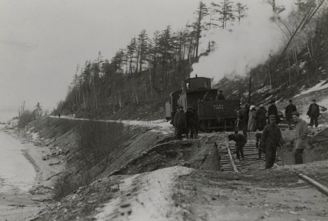
Greenwood Photo Archive Collection from Petoskey newspapers (Undated)
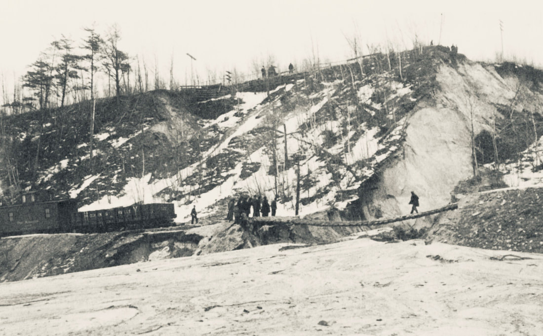
Photo from Page 156 in Resort Township Remembers...
DRAFT minutes below for the 16 March 2020 Petoskey City Council meeting the council voted unanimously to move forward with the $81,620.00 Slope Failure STUDY.
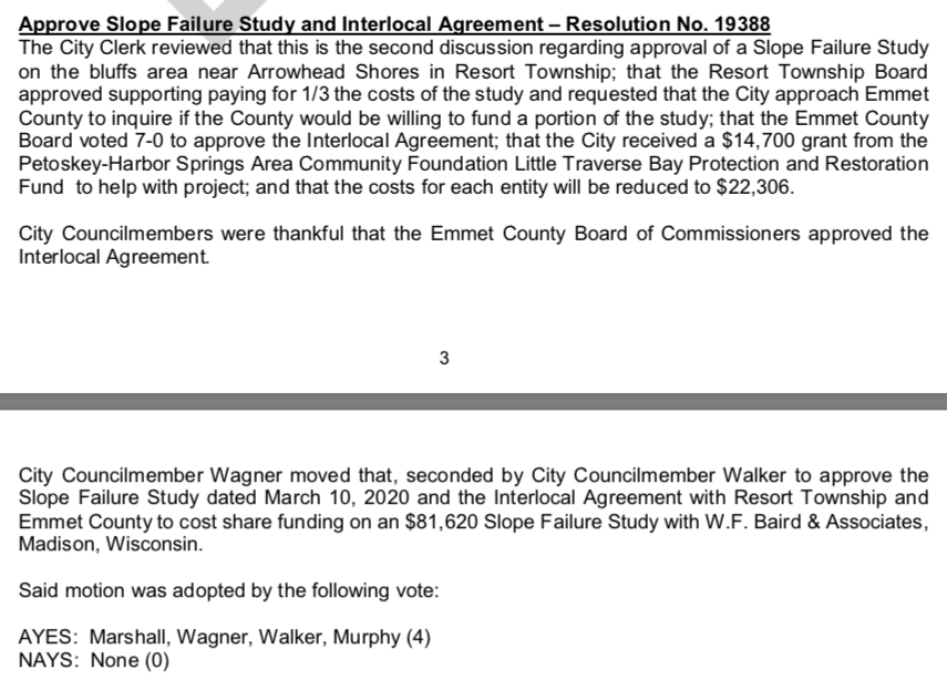
16 March 2020 ~ DRAFT Minutes of Petoskey City Council
2020
Washed Out AGAIN!
Washed Out AGAIN!
Two Photos Below: Charles Dawley of Up North Imaging took these extraordinary photos of the Wheelway... near the overlook on 11 April 2020, only two days before the Washout in the very area that the Washout occurred either in the morning or the afternoon on 13 April 2020. Click on the photos to enlarge for easier viewing. Photo Left: This area with the overlook (for orientation), is just to the right of the area of the washout which is shown in the below right photo. The red arrow points to the area of the Slope Failure which began farther up the cliff on the upper side of the Wheelway.

11 April 2020 ~ Posted Here with permission of Charles Dawley of Up North Imaging
|
11 April 2020 ~ Posted Here with permission of Charles Dawley of Up North Imaging
|
Emmet County Administrator Mike Reaves 13 April 2020 report to the commissioners regarding the Wheelway Erosion STUDY.
Emmet County Administrator Mike Reaves 13 April 2020 report to the commissioners regarding the Wheel Way Erosion STUDY.
Unknown to the ECBOC at the time of the meeting above,
BUT, NOT unexpectedly to anyone,
knowing the historical data about the area,
on 13 April 2020, the Little Traverse Wheel Way was the scene of
a massive WASHOUT in the area of known "slope failure"
(on the location of Wheelway property belonging to The City of Petoskey).
BUT, NOT unexpectedly to anyone,
knowing the historical data about the area,
on 13 April 2020, the Little Traverse Wheel Way was the scene of
a massive WASHOUT in the area of known "slope failure"
(on the location of Wheelway property belonging to The City of Petoskey).
Photo Below: Seagulls attempting to fly in formation at Petoskey waterfront
at the time of the Little Traverse Wheel Way's Washout farther down the shoreline...
at the time of the Little Traverse Wheel Way's Washout farther down the shoreline...
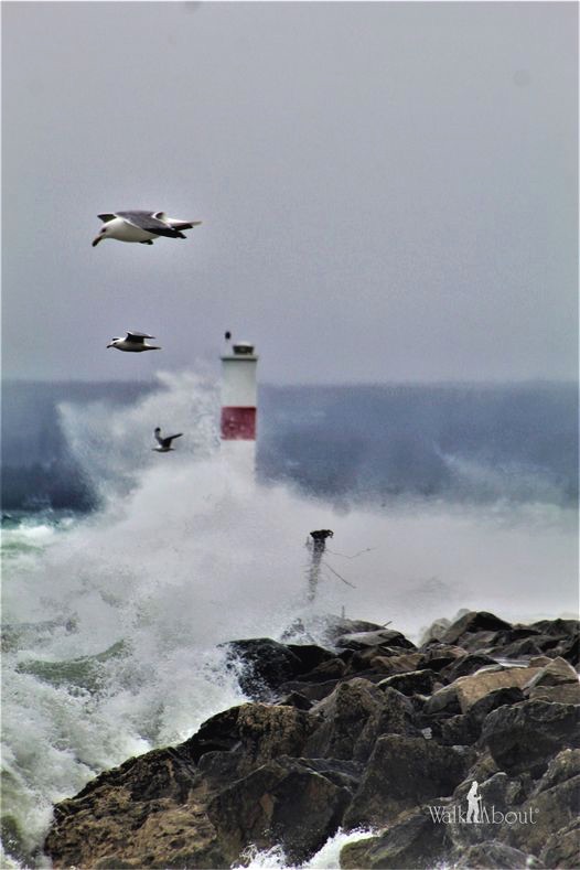
April 2020 Photo By Ken Lewis posted here with his permission...
Below Right Photo AFTER: This area with the overlook (for orientation), is just to the right of the area of the slope failure. It is worth noting that the red arrow points to a small-sized drain within the wall which can release pent up waters which very likely seep into the area from the recorded wetlands and riverines from above. The area above the drain does not show slope failure at this time.
Below Left Photo BEFORE: The drawing on this photo shows the area and route of streamed water that drained from the outlet (a relief valve of sorts); Thus this nearby area did not endure the horrendous slope failure of 13 April 2020.
Below Left Photo BEFORE: The drawing on this photo shows the area and route of streamed water that drained from the outlet (a relief valve of sorts); Thus this nearby area did not endure the horrendous slope failure of 13 April 2020.
DRAIN area still standing strong... SO FAR...
BEFORE AND AFTER WASHOUT
(on 11 April 2020 AND 14 April 2020)
(on 11 April 2020 AND 14 April 2020)
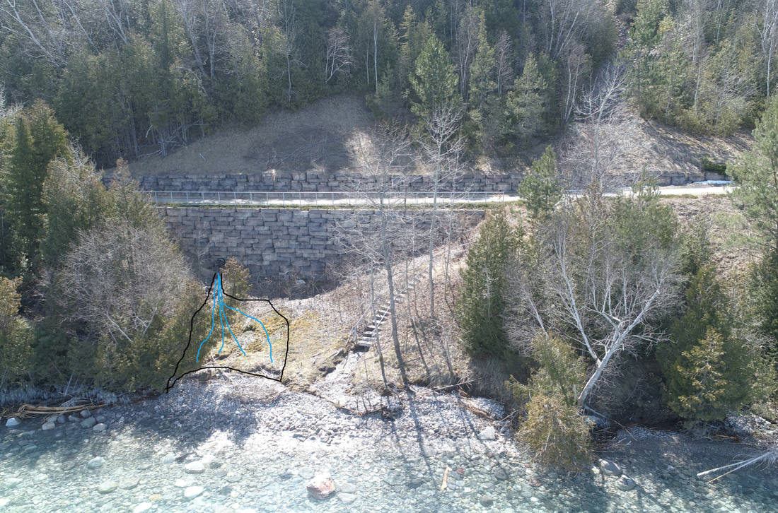
11 April 2020 ~ ~ Posted Here with permission of Charles Dawley of Up North Imaging
|
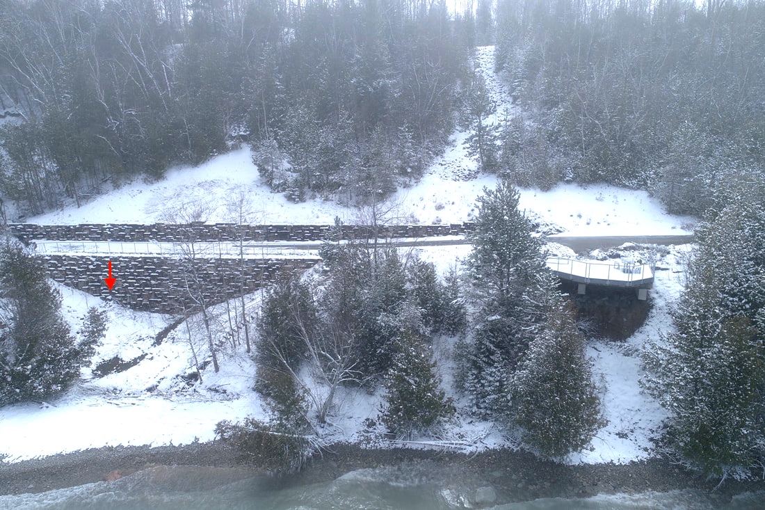
14 April 2020 ~ Posted Here with permission of Charles Dawley of Up North Imaging
|
AFTER WASHOUT
(on 14 April 2020)
(on 14 April 2020)
Photos Below: Charles Dawley of Up North Imaging again took some more extraordinary photos of the Wheelway. With pent up water behind the elevated Wheelway, built so closely to the bay, Mother Nature created Her own "Relief Valve" by creating a massive slope failure. Even with the small drain in the man-made wall above, massive amounts of ground water could be collecting above, just waiting for another pressure relief with more slope failure in the future; especially if the drain were to become plugged. Compare the size of this drain with the size of the open drains, also on the Wheelway, in the photos three and four below.
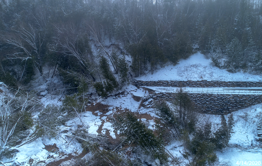
14 April 2020 ~ Posted Here with permission of Charles Dawley of Up North Imaging
|

14 April 2020 ~ Posted Here with permission of Charles Dawley of Up North Imaging
|
Photo 3 Below: From Petoskey, this area on the Wheelway is located BEFORE reaching the slope failure area... with a very similar land topography, but "no apparent damage" from above, or below, from the 13 April 2020 BIG STORM. Notice the drain built into the side of the cliff, allowing pent up water to run below the Wheelway out to the bay. This drain is located almost across from Eppler Road on the top of the cliff. It is probable that this drain existed prior to the design of the wheelway and was incorporated.
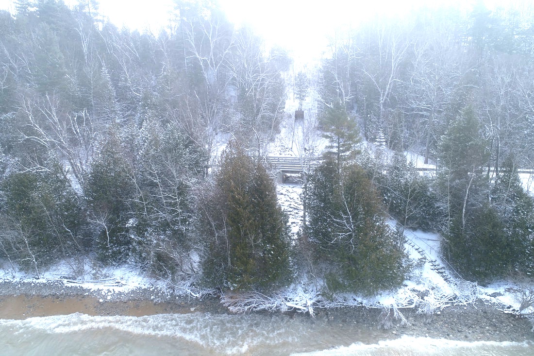
14 April 2020 ~ Posted Here with permission of Charles Dawley of Up North Imaging #3
Photo 4 Below: From Petoskey, this area on the Wheelway also is located BEFORE reaching the slope failure area... with a very similar land topography, but "no apparent damage" from above, or below, from the 13 April 2020 BIG STORM. Notice the drain built into the slope below the Wheelway, allowing pent up water to run below the Wheelway out to the bay. This drain is located next to the Pine Bluffs Condominums (seen at the left at the top of the photo), perched 135 feet above the water, on the highway corner near the fairgrounds heading toward Eppler Road on the top of the cliff.

14 April 2020 ~ Posted Here with permission of Charles Dawley of Up North Imaging #4
It is interesting that in the areas above with types of drainage for relief of any pent up waters,
any erosion SO FAR is not apparent.
any erosion SO FAR is not apparent.
Charles Dawley of Up North Imaging took these extraordinary photos below of the Wheelway...
near the overlook on 15 April 2020.
near the overlook on 15 April 2020.
Photo Below: The washed-out Wheelway is located right on the waterfront with the slope failure visible above (green X), so US 31 rests on the flat level above the slope failure. Eppler Road is at the corner heading right up the hill. Eppler Road was at one time called Washout Road until after the 1913 Washout when Mrs. Eppler petitioned to have the name changed so her produce truckers were not afraid to drive up WASHOUT ROAD (see that factual story farther above). That vacant land in the background on Eppler Road is Greenwood Cemetery which has a riverine ravine running right through it, leading toward the bay. The vacant land shown in the top left hand corner of the photo is a portion of the Emmet County Fairground property.
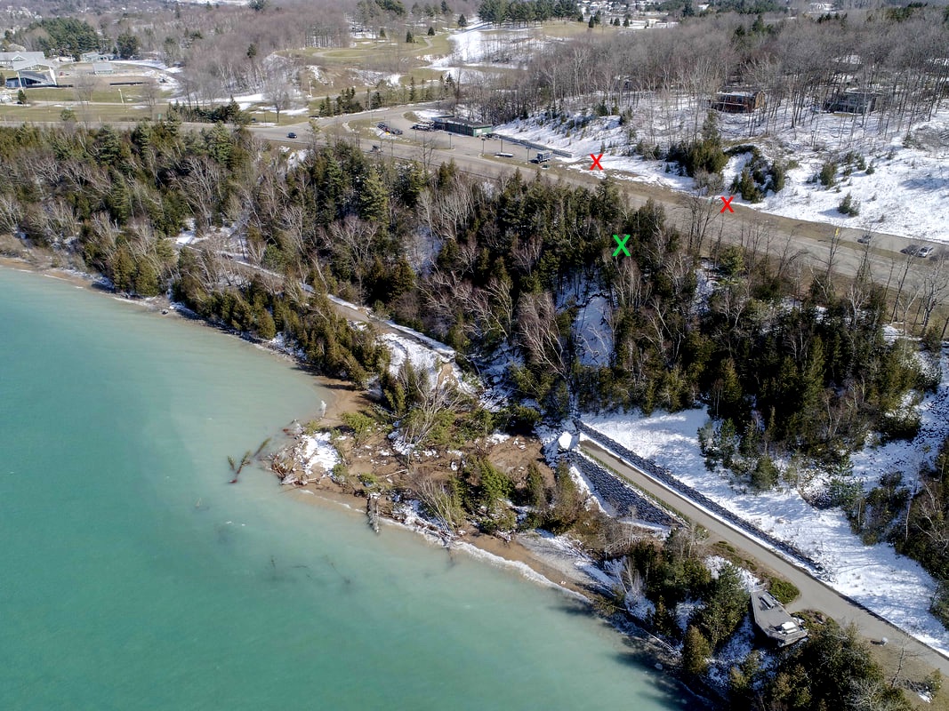
15 April 2020 ~ Posted Here with permission of Charles Dawley of Up North Imaging
16 May 1988 Petoskey News Review Article Below and Photo Above: The red X’s in the photo above designate areas of slope failure across the highway, on the uphill side of the wheelway washout. According to "wetlands maps", those are the areas that have riverines washing down. Plus in 1988, the slope erosion had been further exacerbated by the excavation and removal of sand by Manthei Development Corporation which was hired by the City of Petoskey to attain fill for the city's huge waterfront project. Manthei Development Corporation had received permission from Charlevoix Avenue landowner Jack VanTreese to remove the sand… all without a governmental permit and no oversight.
The Michigan Government Department of Environment, Great Lakes, and Energy states: “If your project is less than 1 acre of total earth disturbance, a Local Soil Erosion Permit may be required. Permit triggers may vary, but typically a permit is required for any project within 500 feet of a lake or stream regardless of size, or for any project OVER 1 acre in earth disturbance. If your project is greater than 500 feet from a lake or stream and under 1 acre in total earth disturbance, you should still contact your local agency to determine if a permit is required, as some counties and municipalities have ordinances that are more restrictive. Specific application and permit requirements can be found by contacting the county or municipal agency where the work is occurring or visiting their website.”
The 1987 land owner Jack VanTreese and the Manthei Development Corporation, with the blessing of county planner Max Putters stated that the removal of the sand, causing slope erosion (actually happening as they watched) and to the detriment to landowners on Tor Lane, may have been an “honest mistake.”
Honestly, the entire event just continued to illustrate how unstable the entire area is… an unwise location ever to continue draining money.
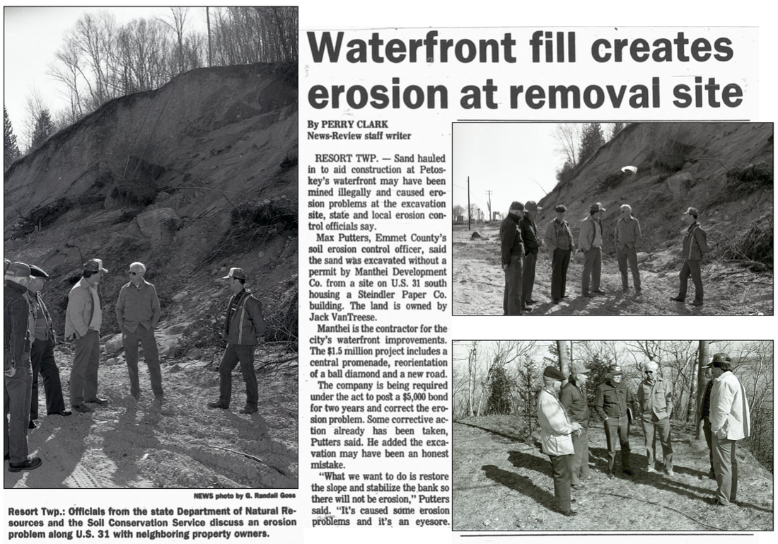
16 May 1988 ~ Petoskey News Review article continued below...
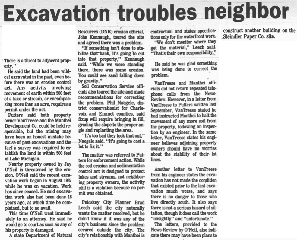
16 May 1988 ~ Petoskey News Review article continued from above...
Clipping Below: In 1981, Steindler Paper Co. mentioned in the above article, previously had been located
on Elizabeth Street in downtown Petoskey, moved to the 2380 Charlevoix Avenue area of the slope erosion.
on Elizabeth Street in downtown Petoskey, moved to the 2380 Charlevoix Avenue area of the slope erosion.
8 June 1981 ~ Petoskey News Review
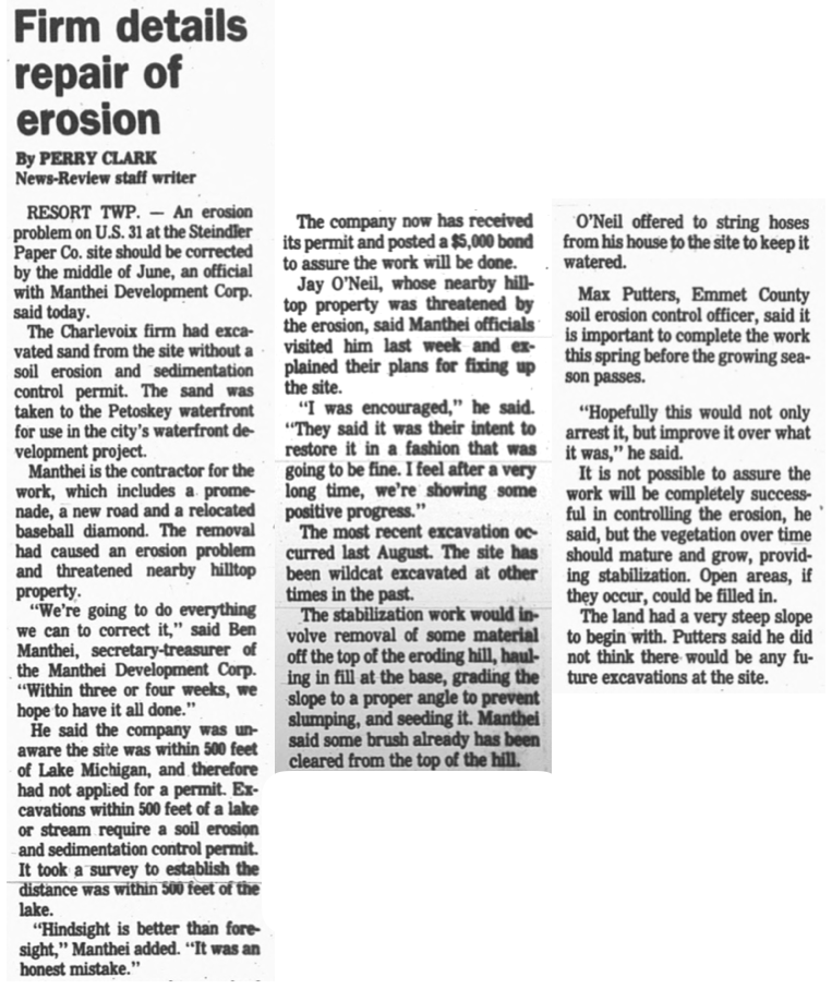
23 May 1988 ~ Petoskey News Review
Map Below: This wetland map shows the particular location of the riverines that begin on top of the area including Eppler Road and Sheridan Road with one branch beginning near Vantage View Subdivision and the other branch beginning near the new EMS station which continues to experience water problems. The riverines extend across Sheridan Street, joining in the ravine of Greenwood Cemetery to flow toward Tor Lane community, across US 31, and on toward the bay (shown underneath the US 31 sign on the map)... pretty much in the area of the 13 April 2020 Wheelway and Slope Failure.
A 3 September 2019 Petoskey News Review article titled
"Emmet County EMS Station to Undergo Repairs"
describes the extent of water damage, and the expensive bid options for repair.
"Emmet County EMS Station to Undergo Repairs"
describes the extent of water damage, and the expensive bid options for repair.

Wetlands Map Viewer from Department of Environment, Great Lakes, and Energy captured 15 April 2020 (Click to Enlarge)
Photo Below: Compare this photo to the wetland/riverine map above showing the Greenwood Cemetery location including a large ravine running toward the Wheelway Slope Failure. Also, notice in the photo below, the farmland pond which is higher on the riverine path. This fragile land area is not just a figment of someone's imagination because it cannot be totally seen with the naked eye. It does exist! Read from the State of Michigan Introduction to Wetland Management to learn about wetlands by clicking HERE. "Wetlands are often transitional zones between dry upland sites such as old fields and forests and open-water areas such as lakes and rivers."
Photo taken 7 April 2020 by Charles Dawley and posted only Here with his permission.
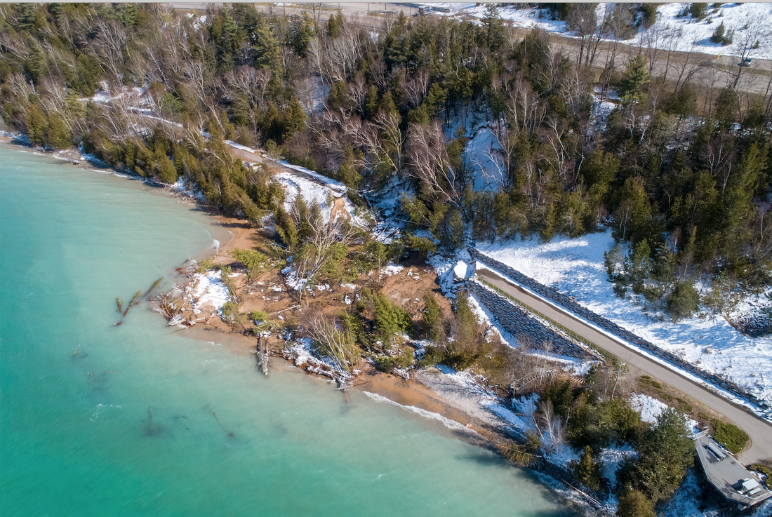
15 April 2020 ~ Posted Here with permission of Charles Dawley of Up North Imaging
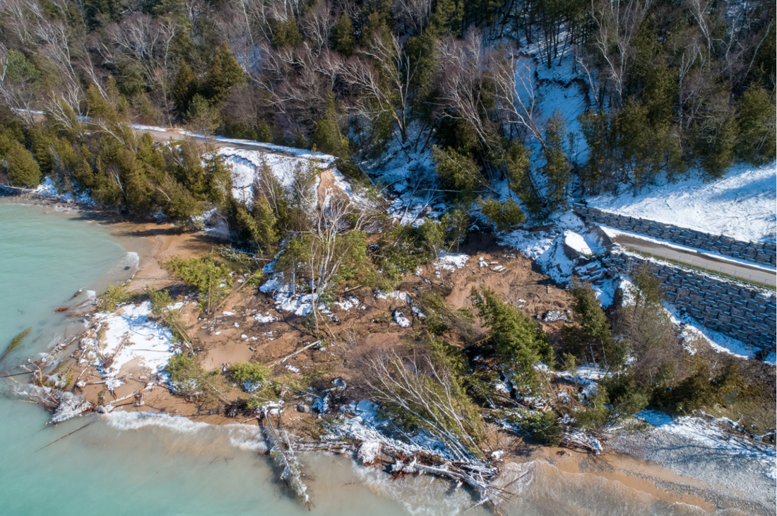
15 April 2020 ~ Posted Here with permission of Charles Dawley of Up North Imaging
Photos Below: ... just for historical perspective of when the TRAIL was RAIL...
and the slope failed then in the same general area as in 2020.
and the slope failed then in the same general area as in 2020.
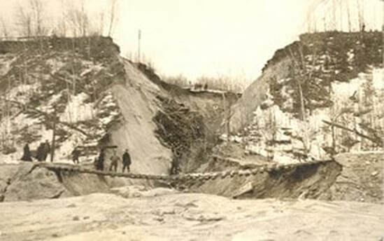
Greenwood Photo Archive Collection from Petoskey Newspaper
|
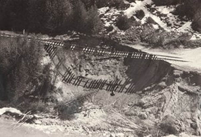
Greenwood Photo Archive Collection from Petoskey Newspaper
|
|
~ 1913 Washout ~
(Affected the roadway ABOVE AND the railway BELOW)
14 August 1913 ~ The Petoskey Record
|
~ 1957 Another Washout ~
2 July 1957 ~ Petoskey News Review
|
Charles Dawley of Up North Imaging took these extraordinary photos below of the Wheelway...
near the overlook on 15 April 2020, two days after the massive eroded slope.
Click on the photos to enlarge them for better viewing.
near the overlook on 15 April 2020, two days after the massive eroded slope.
Click on the photos to enlarge them for better viewing.
15 April 2020 ~ Posted Here with permission of Charles Dawley of Up North Imaging
|
15 April 2020 ~ Posted Here with permission of Charles Dawley of Up North Imaging
|
15 April 2020 ~ Posted Here with permission of Charles Dawley of Up North Imaging
|
15 April 2020 ~ Posted Here with permission of Charles Dawley of Up North Imaging
|
Photo Below: The perspective includes the location of the wheelway slope failure (bottom right corner) to the
Emmet County Fairgrounds, the Greenwood Cemetery, and on toward Downtown Petoskey.
The slope failure short distance from US 31 is very concerning.
Emmet County Fairgrounds, the Greenwood Cemetery, and on toward Downtown Petoskey.
The slope failure short distance from US 31 is very concerning.

15 April 2020 ~ Posted Here with permission of Charles Dawley of Up North Imaging
Photo Below: This area of land is owned by the City of Petoskey on the lower level where the failed Wheelway runs. The upper portion of land, "which does not access the water's edge", is owned by Emmet County, purchased in 2004 along with other Dwan property. The measurement from the top starting area of the slope failure, to US 31 highway, is approximately 75 feet... dangerously close to the roadway. A 1948 article farther below this photo explains the mentality of the road designers and engineers during the timeframe US 31 was built, and very likely the same mentality existed for the designers and engineers for the Wheelway... a SCENIC THRILL! Yep... that is what the 1948 article below says, and what a 2020 description below of the Wheelway alludes.
~ Wheelway and US 31 ~

15 April 2020 ~ Posted Here with permission of Charles Dawley of Up North Imaging (The car in the photo is headed into Petoskey on US 31)
Yep, SCENIC THRILLS...
that is what the article below says about US 31 between Petoskey and Charlevoix,
and a description below of the Wheelway alludes to the same SCENIC THRILLS.
Pay no mind to public safety or public expense, for maintaining, or repairing,
such original faulty engineering.
This particular area of slope failure is but one, of many areas,
that shows up presently between Magnus Park and East Park.
This slope failure near the overlook just happens to be the major SCENIC THRILL to occur right now.
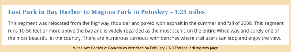
Clippings Below: NEW Highway, US 31 from Petoskey to Charlevoix is Closer to Little Traverse Bay...
Previous to the new US 31 Highway, the main road from Petoskey to Charlevoix was
Old State Road... which includes NOW, Sheridan Street.
Scenic THRILLS!
Previous to the new US 31 Highway, the main road from Petoskey to Charlevoix was
Old State Road... which includes NOW, Sheridan Street.
Scenic THRILLS!
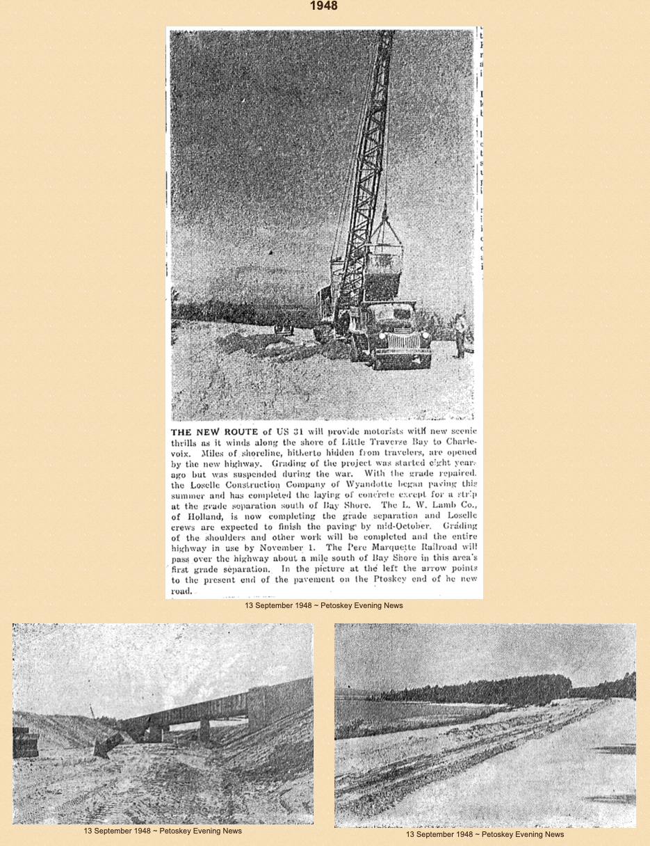
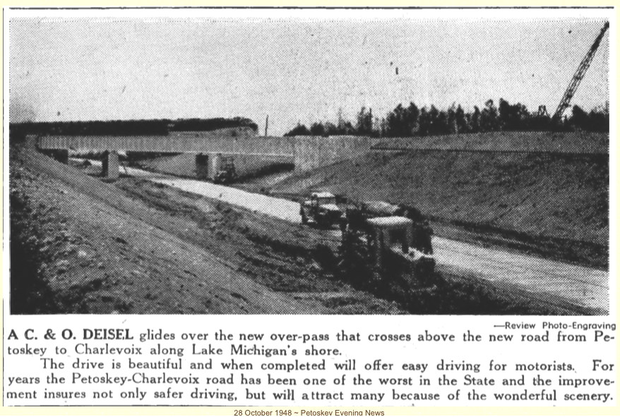
The 13 April 2020 Wheelway SLOPE FAILURE falling so closely to US 31 brings to mind...
Not quite two years ago on 5 June 2018 the News Review article titled
"Road Revamp $14.8 million in US-31 Renovations still Slated for 2019"
offered an explanation of the total plan for the project.
Click HERE to access the article.
The situation was the SAME as this 13 April 2020 Wheelway Slope Failure...
US 31 near Sunset Park just north of Petoskey required moving away from the deteriorating cliff.
The sidewalk along this section of roadway had been closed for several years
because the underneath was "giving way" as noted in the photo below looking south bound.
The roadway was moved to the east for better support of this major roadway
leading from the collapsed wheelway area, then on through Petoskey, Michigan.
Photo Below: Posted on this Northern Mich~Mash Preserve web site only by permission from
remarkable photographer and videographer Charles Dawley of Up North Imaging.
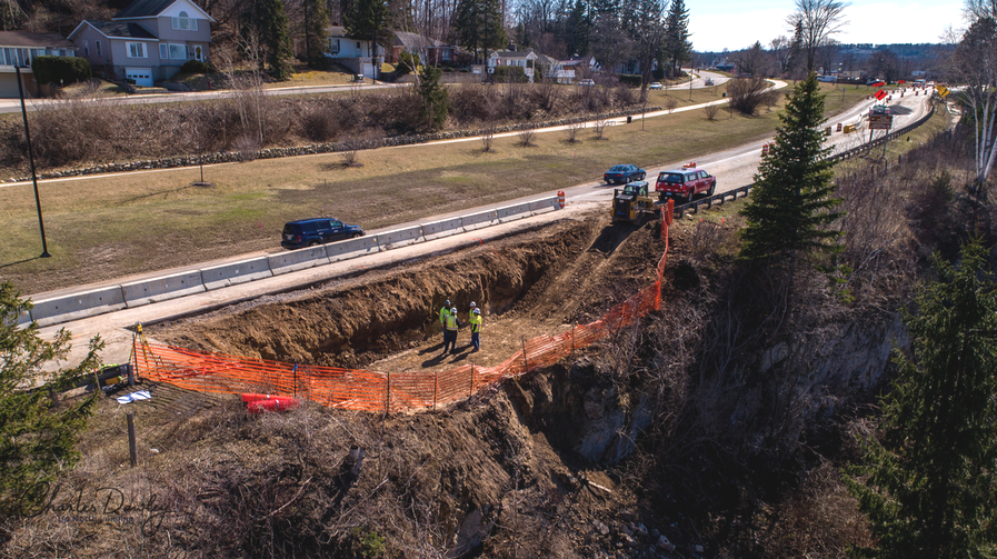
12 April 2017 ~ Charles Dawley (permission to post only on this Northern Mich~Mash Preserve web site)
Photo Below: Posted on this Northern Mich~Mash Preserve web site only by permission from
remarkable photographer and videographer Charles Dawley of Up North Imaging.
The MDOT (Michigan Department of Transportation) on 21 April 2020, on US 31,
was in the process of taking soil borings [NOT TRUE] near the location where on 13 April 2020;
located only about 75 feet from the highway the slope failed, and slid down over the wheelway.
LATER UPDATE from communication with MDOT official on 21 October 2020:
MDOT did NOT take soil borings.
MDOT only installed inclinometers and monitoring wells near the top of the slope;
one on the north of US-31 (Ground water elevation at 610.13)
and one on the south side of US-31 (ground water elevation 606.03)
and then groundwater was seen discharged at elevation 597.85
about 7 feet from the north side of the pathway.
MDOT also posted "visual delineators" for someone to "almost daily" observe for movement.
[UPDATE: Visual Delineators are no longer being monitored]
MDOT feels the US-31 is stabilzed; otherwise further action would be taken,
if MDOT felt it was unstabilized.
Petoskey City Manager Straebel's Update in the 20 April 2020 City Council DRAFT minutes stated: "The Little Traverse Wheelway coastal bluff collapsed last week; that MDOT is sending a team of geotechnicians from Lansing to install ground instrumentation to monitor any further movement on the bluff."
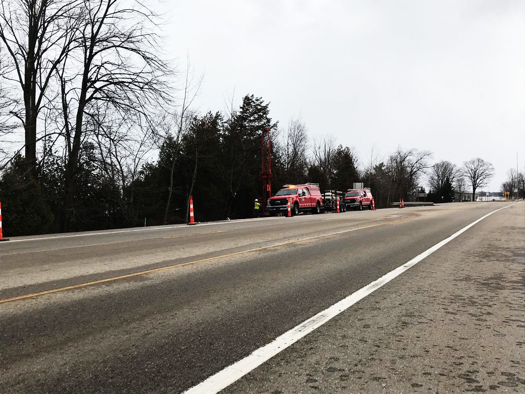
21 April 2020 ~ Submitted by Charles Dawley of Up North Imaging to be posted only HERE on this Northern Mich~Mash Preserve web site...
The 22 April 2020 Petoskey News Review article titled "City Official Recreation Director Kendall Klingelsmith warned: 'The problem with that is the ground is still unstable, and the affected area is likely to continue to expand.'"
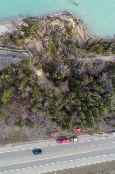
Greenwood Photo Archive Collection from Petoskey newspapers (2020)
Emmet County Administrator Mike Reave's Administrator's Report Below for 23 April 2020 ECBOC meeting: Interesting comment is... "MDOT has been notified and now has become involved in this process. I believe that this is strongly needed, as there appears to be several other factors possibly involved in the recent slope failure, other than a bottom up approach (lake level up to wheel way trail)." Good thing the taxpayers are paying for an $81,000.00+ STUDY to lead the way to the inevitable end.... (written facetiously).
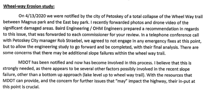
Emmet County Administrator Mike Reave's Administrator's Report for 23 April 2020 ECBOC meeting...
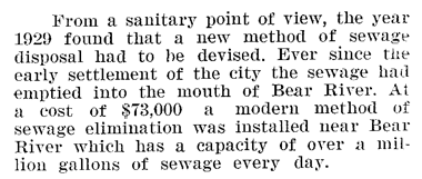
"Souvenir of Petoskey Homecoming–A History of the Past and Present" 1938 (Page 30)
Two Photos Below: Posted on this Northern Mich~Mash Preserve web site only by permission from
photographer and videographer Charles Dawley of Up North Imaging.
As the Wheelway approaches the City of Petoskey Wastewater Treatment Plant,
"Trail Closed" signs are posted on the closed off Wheelway.
The Wheelway is close to the shore in this space, but appears to have weathered the high waters, lending more credence to the reason for the major slope failure farther around the path corner;
that being erosion from ABOVE... not as much from the high waters of the bay.
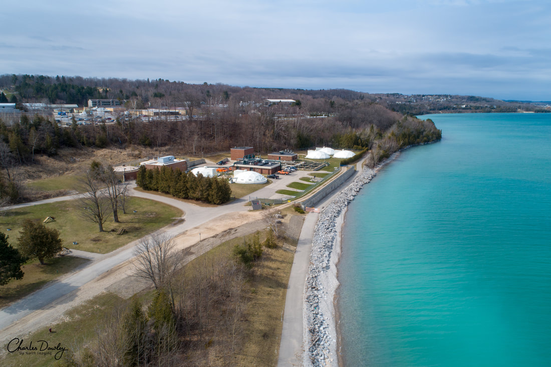
23 April 2020 ~ Charles Dawley (permission to post only on this Northern Mich~Mash Preserve web site).
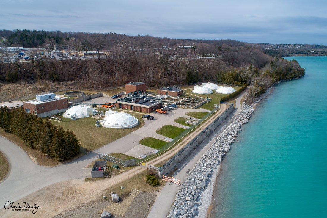
23 April 2020 ~ Charles Dawley (permission to post only on this Northern Mich~Mash Preserve web site).
ALTHOUGH...
when the Treatment Plant area was eroded in 1986, it left the railroad track hanging (shown below)...
when the Treatment Plant area was eroded in 1986, it left the railroad track hanging (shown below)...
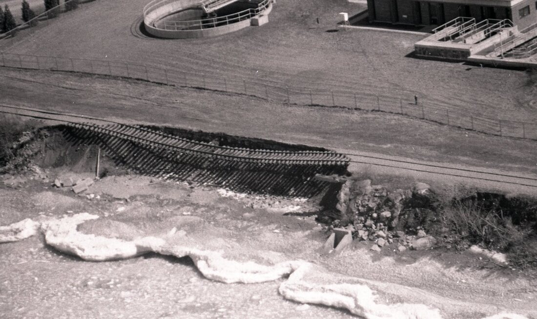
Greenwood Photo Archive Collection from Petoskey newspapers (1987)

1 July 1986 ~ Petoskey News Review headline accompanied article below...
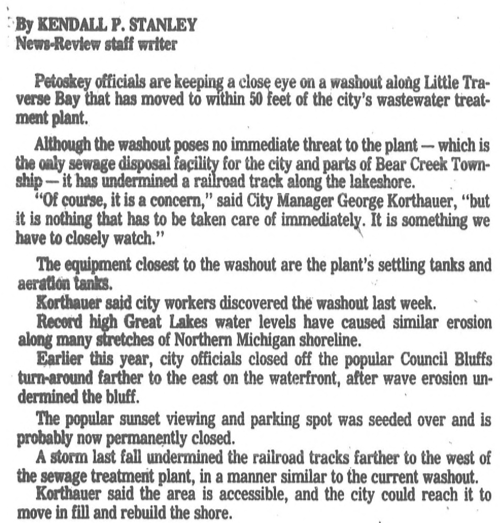
1 July 1986 ~ Petoskey News Review article accompanied article above...
|
Greenwood Photo Archive Collection from Petoskey newspapers (labeled 1987)
|
Greenwood Photo Archive Collection from Petoskey newspapers (labeled 1987)
|
1986 Article and Photo/Text Below: The unstable slopes under the railroad tracks were openly known, but certain governmental officials, and trail groups, pushed forward, spending, and ultimately wasting, MILLIONS of taxpayer dollars, with the 2020 eroded wheelway.
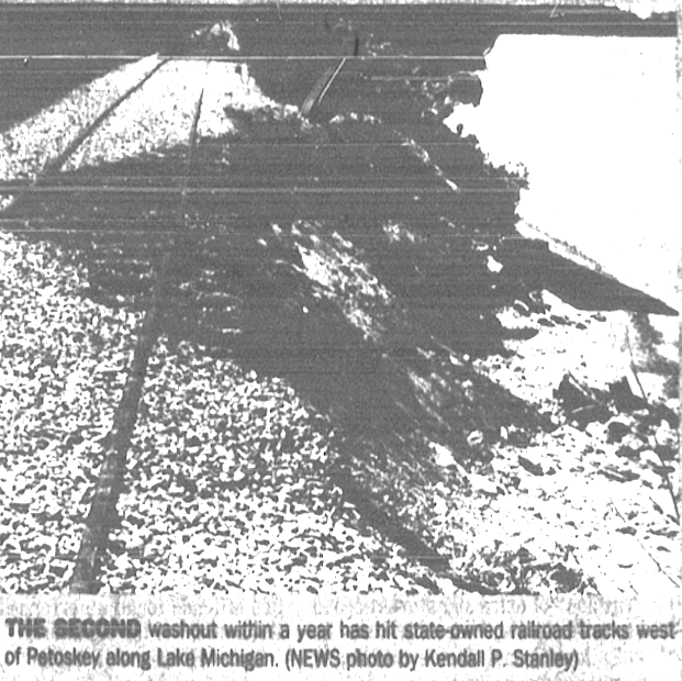
1 July 1986 ~ Petoskey News Review photo/text accompanied the article right...
|
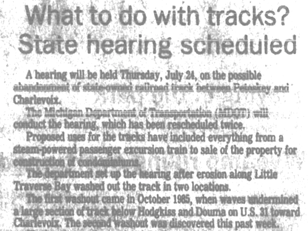
1 July 1986 ~ Petoskey News Review article was accompanied by the photo/text left...
|
MDOT will do well to learn from the PAST, and act accordingly.
Whether effects of high bay water or riverines above bay level...
Whether a "Dream Home" or a "Trail Way"
1980...
Whether effects of high bay water or riverines above bay level...
Whether a "Dream Home" or a "Trail Way"
1980...
24 June 1980 ~ Petoskey News Review
A 26 March 1987 Petoskey News Review article headline read: "New Shore Erosion Expected".
"During the past 120 years, when most lakeshore development occurred, lake levels apparently have been at historical lows. Now, lake levels are rising. Nature is relclaiming land previously underwater. Emmet County has 70 miles of Lake Michigan shoreline. Last year the emergency services department distributed 20,000 sandbags. This year it purchased 20,000 more."
"John Theisen, director of emergency services for Emmet County, said shoreline erosion caused more that $150,000 in damage last year in Emmet County. That's not counting damage to a railroad line deemed too costly to repair."
(Photo/Text Below accompanied this referenced article)
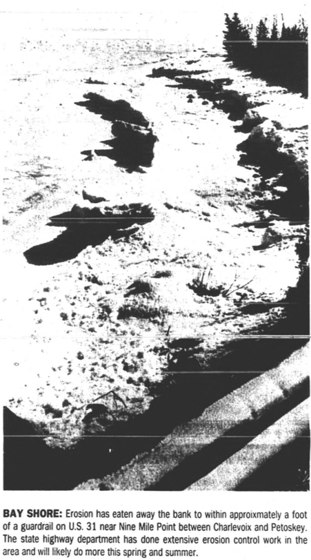
26 March 1987 ~ Petoskey News Review photo/text accompanied article referenced above...
Emmet County Administrator Mike Reave's "Administrator's Report" below for 11 May 2020 ECBOC meeting: Perhaps Baird Engineering and OHM Engineering is doing its own research, and putting together its own documentation for a report toward the work contracted for their $81,000.00 report?
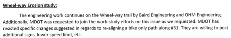
Emmet County Administrator Mike Reave's Administrator's Report for 11 May 2020 ECBOC meeting...
The 12 May 2020 Petoskey News Review published an article titled "Officials Await Long-Term Erosion Fix." The governmental entities that have involved themselves through paying for a STUDY, are still waiting for any report of any information which that company has researched itself. City Park Director Klingelsmith's comments indicated that "flooding or erosion problems are likely to continue before the $81,600.00 STUDY is finalized at the end of the summer. But the danger in taking any immediate, interim action is that the entities would be going in somewhat blind, and could risk throwing money at a fix that would just wash away." Emmet County Administrator Mike Reaves said at a meeting last week, "Baird made a proposal that we would immediately intercede and... for us to guarantee funding for an immediate fix. We had that discussion and I told them we wouldn't be interested in that because we don't believe it may be done faulting at this point. If a temporary fix failed 'any money that would be put into that would immediately be lost, and we didn't sign on for any type of fix at this point.'" Additional article text may be accessed by clicking HERE.
Minutes Below from the Emmet County Road Commission 13 May 2020 meeting: One has to wonder what the Baird Company has been doing to earn the $81,000+ for the contracted study they were to perform. Their first report had NO research of their own; just information, and drone photos, not of their own and gathered from the internet. So, will their next report just be a presentation of the state's "probe" results?
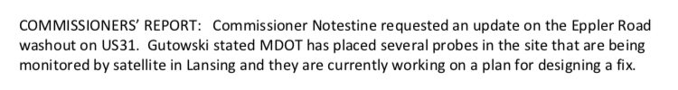
13 May 2020 ~ Emmet County Road Commission meeting minutes...
Clipping Below: The Petoskey City Council in the midst of the COVID–19 discussed in their recent meeting just how the virus was affecting their entire budget, and in particular the Little Traverse Wheelway resurfacing...
28 May 2020 ~ Petoskey News Review
The City of Petoskey had hired, and had been working with Baird and Associates, for another project,
before recommending to Resort Township and the county, hiring Baird to do the Wheelway Baird Report.
before recommending to Resort Township and the county, hiring Baird to do the Wheelway Baird Report.
6 July 2020 ~ Part of the City Manager Strabel's report included in the packet for the city meeting of this date.
Regarding the City Manager's Report Above: On 9 March 2020 the Emmet County Board of Commissioners approved joining the city and Resort Township in an over $81,000.00 Slope Failure Study; a Study said to be an emergency necessity. The Baird Study so far has merely gathered, and presented, historical information that is available on the internet on sites such as this very Northern Mich~Mash Preserve. The photos in that same Baird report were ones taken by a private individual; not of Baird's own doing. So, it will be interesting to see what THEIR "next shoreline findings" for the city will be at the 6 July 2020 city meeting... those findings said to NOT be associated with the Arrowhead Shores Slope Failure Study; not to be completed until in early August. It will probably include a report of findings of the Michigan Department of Transportation team of geotechnicians' findings from their ground instrumentation to monitor any further movement on the bluff. Hmmmm... it would seem that, that MDOT public information would be accessible without having to pay Baird to just copy, and present, that information. Anyway, this little blurp is all that the township, city, and county have received for their thousands of dollars so far.
25 August 2020 Petoskey News Review reported: The Baird Report will determine the future of the washed-out Wheelway. City Manager Robb Straebel said at a previous meeting, "I think by and large the slope failure study is going to dictate what location the trail's going to be at. Is it going to be on the highway or is there an engineering solution that's not cost prohibitive that would allow us to repair the current Little Traverse Wheelway?" The study still is not ready to be presented as a "draft" so presentation will be postponed for a need for thoroughness. So, $81,000.00 later? Still no results!
14 September 2020 Petoskey News Review reported: "Report on trail erosion will be presented to the public next week"... adding "Officials have a rough draft of that report in their possession right now, despite a minor delay from Baird last month. But none of those involved are saying much about the contents of the report until representatives from Baird have a chance to present the document formally." Baird responded to the secrecy: "'We need these reports to stand on their own because they are very, very technical and interpreting them in any other matter than as written can sometimes be problematic,' Ed Liegel a Baird engineer said. "The city's Klinglesmith said the involved entities met in a private meeting and presented questions for Baird to answer. He thinks it is best to roll this out at a public meeting for questions to be answered by the firm that completed the study."
So much for any advance transparency.
So much for any advance transparency.
21 September 2020
The BIG Reveal!
"Petoskey Slope Failure Study"
(Dated 26 August 2020, so actually presented to the public almost ONE MONTH after it is dated)
Baird Innovation Engineered
The BIG Reveal!
"Petoskey Slope Failure Study"
(Dated 26 August 2020, so actually presented to the public almost ONE MONTH after it is dated)
Baird Innovation Engineered
An inter-local (City of Petoskey, Resort Township, and Emmet County) Zoom meeting was held on 21 September 2020 at 7PM (at the beginning of the regular City Council meeting) for the purpose to “Hear Presentation from Baird and Associates concerning Slope Failure Study.”
The inter-local entities’ taxpayers paid $81,000.00+ for the presented study, so one might think that the taxpayers had paid for a public document, but NO. The study is copyrighted in whole and every part of the document. So, no copies, but if anyone is interested in viewing the document it can be found on-line through the City of Petoskey 21 September 2020 Agenda packet: Click HERE.
When the Emmet County Board of Commissioners [ECBOC] agreed to become a party in paying for 1/3 of the Baird study, the county's Board Chairman “required that the STUDY include, not only the high bay water in front of the wheelway be studied, but also the waters (could be wetlands and riverines) behind the wheelway be included in the study. The city manager agreed to all of the county's requests.” The Baird Project Area Description, however, states: “The area of focus (battery limits) for this study area is concentrated on the bluff and trailway corridor, extending from the shoreline to U.S. Highway 31”, so nothing south of US 31. On page 52 Baird suggests: “a hydrogeologic study may be of benefit as long term solutions to stabilizing the slope are explored.” Why was this already not done, as the county chairman had requested, and why was it not included in the $81,000.00+ study; if a current existing governmental Wetlands Map could not be trusted to reveal the very results of a hydrogeologic study?
It is obvious just by looking at the Table of Contents of the Baird Study, that only issues/topics located between the road, and into the water a short distance, were studied; no mention of a wetland, nor a riverine, on the above property south of US 31 affecting the massive erosion or any sloughing was discussed in the study. The study acknowledged data from other various entities like MDOT, and the previous engineering group Northern Design Group (NDG now OHM) that engineered (NDG studies of 2005 were included in the Baird Study) and designed the present failed wheelway, NOAA, USACE, LiDar, and Baird’s actual testing, itself; although admitting only to wading to a depth of 3 feet for the profiles. Otherwise, it seems Baird walked the site, and used data from others, whether up to date, or not.
Baird representatives made no secret of the use of the data from multiple various sources, but Baird made no mention of attempting to access an Emmet County Wetlands Map which shows that two sizable riverines meet on top of Eppler Road (previously called Washout Road) and flow closely toward the massive wheelway erosion area. Local newspaper articles documented this same 2020 verifiable spot having been affected in 1911 (Reverend Weaver's horses dropped down in the washout and one was killed), 1912 (September), 1913 (March), 1916 (May), and 1957 (July); now again on 13 April 2020. In fact, in 1985 (November), it was reported that just a bit farther down the wheelway toward Charlevoix, at another riverine escape-way (showing on the Wetlands map) that a washout ravaged the railroad track near Petoskey Plastics, Inc. Then, the State of Michigan voiced they did not wish to spend a million dollars for that repair because they could not promise it would last (see article farther above on this same web page stating this fact).
It is unclear/unavailable exactly what any hiring contract with Baird may have entailed, but the Baird Study states on page 1 that the “Owner (the inter-local entities) retained W.F. Baird & Associates Ltd. (Baird) and OHM Advisors (OHM) to perform a preliminary investigation and analysis of the shoreline/bluff, and develop conceptual design alternatives to potentially mitigate the ongoing issues(s).” So, is OHM the Associates part of the Ltd. name? The retaining of Baird was clearly known from the beginning, but the OHM retainment is a bit surprising. Presently, OHM is the owner/purchaser of the same NDG engineering firm which designed and engineered the now failing eroding wheelway. Did NDG sign a guarantee in 2008 for their engineering of their proposed, and constructed, 2008 wheel-way; for a wheelway design that is eroding away in less than 12 years? This should make taxpayers a bit reluctant for their officials to make decisions based on Baird's use of the same old NDG soil borings of June of 2005 information (pages 13-14-15 of the present Baird Study), and to spend MILLIONS and MILLIONS of taxpayer-dollars for mitigation based on data which obviously already has proven useless! The study's proposed Mitigation Measures are projected to cost millions of taxpayers' dollars.
The below old 20 February 2007 Petoskey News Review article is revealing in a couple of ways. First, this was the confirmation of the Petoskey City Council voting to authorize the contract with NDG [HMO in 2020 Baird Study] for the engineering services as part of the planning efforts for the Wheelway segment between Petoskey's Magnus Park and Resort Township's East Park, the very segment being studied for possible design and engineering AGAIN in 2020. Petoskey would pay NDG for services not to exceed $190,000.00. The article went on to explain the various millions of dollars to be invested by various governmental entities. Second, this indicates that NDG was being hired for this wheelway segment in 2007, so how does the Baird Study report on its page 13 state, "Northwest Design Group (NDG) originally completed five (5) soil borings throughout this area in June of 2005. The location of these historic soil borings is shown in Figure 2.8. What was that all about for NDG to have performed soil borings in that area in 2005 even before NDG openly was hired in 2007? Just how reliable is the information presented in the Baird Study?
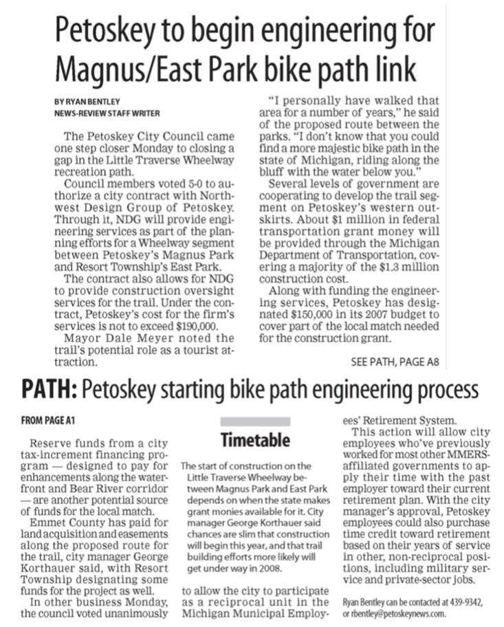
20 February 2007 ~ Petoskey News Review
On page 41 of the Baird Study Profile 3 Summary stated while admitting that the upper part of the slope failure was likely due to the geometry and steepness of the ground in that area, that “interestingly, for this particular slope geometry, the toe erosion played a greater role than the groundwater elevation, although both features led to measurable differences in the stability of the slope.” The photos below taken two days after the 13 April 2020 massive slope failure certainly shows still that the eroded sand had saturated farther up the slope from the upper south side of the wheelway. It is doubtful that the wave action from the bay would have saturated the sand so far up slope, almost reaching US 31.
Photo Below shows the disappearance of the wheelway:
The soil that has come down from the above slope is visibly saturated, and had flowed in a mud-like state.
This soil was not saturated from high water in the bay.
The soil that has come down from the above slope is visibly saturated, and had flowed in a mud-like state.
This soil was not saturated from high water in the bay.
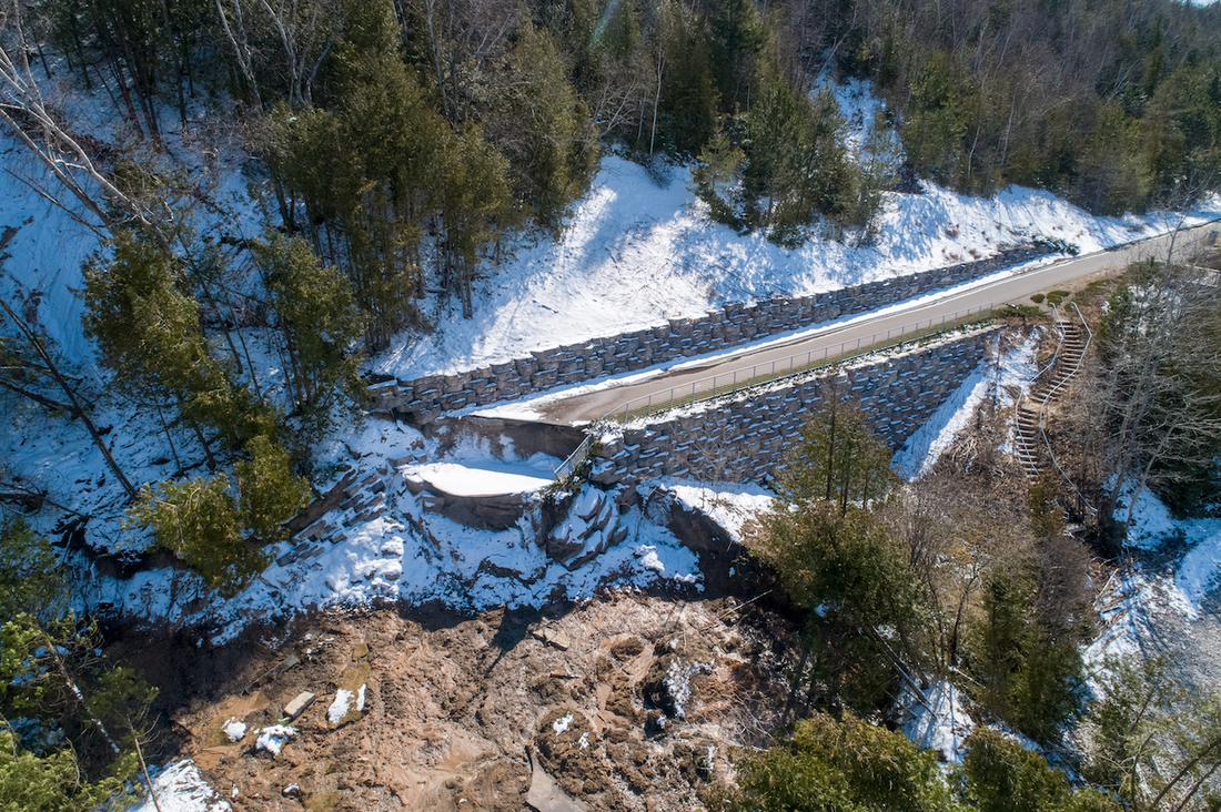
15 April 2020 ~ Charles Dawley (permission to post only on this Northern Mich~Mash Preserve web site).
Photo Below just to the left of the photo above showing the other end of the disappearance of the wheelway:
The visible standing sand at the left is not even wet due to any high bay water...
although, the soil that has slid and flowed from above is saturated.
The visible standing sand at the left is not even wet due to any high bay water...
although, the soil that has slid and flowed from above is saturated.
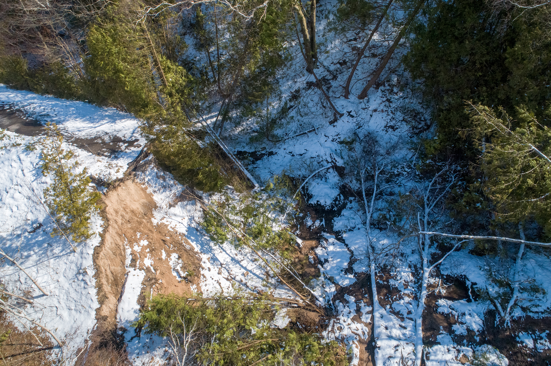
15 April 2020 ~ Charles Dawley (permission to post only on this Northern Mich~Mash Preserve web site).
Vegetation Root Systems
It stated on page 44 of the Baird Study that vegetation root systems helping to hold the soil in place must be considered: “The infinite slope analysis used was modified to help take into account the effects of root systems within the ground.” In that sentence, then, is Baird acknowledging that the lack of vegetation, and thus the lack of roots in the exact route of the 13 April 2020 massive slope failure erosion was ignored by NDG/OHM even before the wheelway was constructed in 2008? Why should the taxpayers be accepting of such analysis for the projection of "root systems tending to add strength to the ground," especially when a trail lacking vegetation is obvious from US 31 right down to the water near to where the slope failure has recently occurred? Did NDG/OHM even inspect the vegetation on the slopes above their designed and engineered 2008 wheelway? Three Photos Below: Observing the 2008 GIS map of the slope failure area, even before the overlook was installed, and also the 2012 GIS map of the same slope failure area, the lack of trees and other vegetation is quite visible near to the very route of eroded slope from US 131 right down to the water!
Photo Below: This 2008 Emmet County GIS Map shows that even during the year 2008, but before the wheelway was constructed in 2008, the slope in the area of the massive slope failure of 13 April 2020 was lacking much vegetation in a trail from US 31 right down to the water's edge (pointed out by the red arrows). That particular area of the wheelway, however, was designed with a drain, and did stay strong through the recent slope failure. The 13 April 2020 slope failure developed nearby, although, a little farther to the east of the red arrows, where vegetation is especially lacking north of US 31 and south of the wheelway.
2008 ~ Emmet County GIS Map
Photo Below: This 2012 Emmet County GIS Map shows the path of the future (2020) slope failure of the wheelway, lacking much vegetation especially south of the wheelway in that area and just north of US 31 (pointed out by the red arrows).

2012~ Emmet County GIS Map
Photo Below: This 2017 Emmet County GIS Map shows that even 2 1/2 or 3 years before the wheelway slope failure in 2020, the slope in the area of the massive slope failure of 13 April 2020 was lacking much vegetation especially south of the wheelway and just north of US 31 (pointed out by the red arrows). This area of the wheelway, however, was not designed with a drain, and obviously could have a super saturated soil on that upper slope, getting ready to erode. The yellow arrow points out a large long-time existing drain that allows water flowing down a similarly non-vegetated slope to flow UNDER the wheelway on to the lower water's area. No washout occurred here recently.

2017~ Emmet County GIS Map
In 2021 multiple drains exist at US-31 curb edges in this area. It would be interesting to learn the outlets for the massive amounts of water that musts flow from atop the Eppler Road area. Part of that flow would go to the seemingly working drain that goes under the railway, pointed out by the yellow arrow. Additional drains are present closer to the area of the massive washout. Where does all of that water drain? The answer to questions about the US-31 drains in that area were asked of Matt Radulski of MDOT, but the questioner was told that information would have to be FOIA'd [Freedom of Information Act] from the MDOT. Could this US-31 drainage be adding to the convergence of riverine waters in promoting massive slope erosion?
Prior to the construction of the present 2008 wheelway,
numerous community leaders had one goal… construct a wheelway.
Cost be damned. Come what may… hell and high water!
Now, officials need to assess the hell and high water,
and make a decision of whether MORE MILLIONS need to be damned.
numerous community leaders had one goal… construct a wheelway.
Cost be damned. Come what may… hell and high water!
Now, officials need to assess the hell and high water,
and make a decision of whether MORE MILLIONS need to be damned.
Baird Study presentation of 21 September 2020 included the following Two Options:
Option 1 – Repair using Stone Revetment model at an approximate cost of $6.6 million.
Option 2 – Repair using Cobble Beach model with an approximate cost of $7 million.
In addition there will be a need for additional studies, and ground monitoring. There are many grant funding opportunities available when considering funding for the project through agencies such as MDOT, MDNR, etc. Regulatory approvals will also need to be obtained and a detailed engineering plan produced.
So, after Rory Agnew, head of the project and Baird Study, completed his Baird Study presentation to the interlocal entities (City of Petoskey, Resort Township, and Emmet County) on 21 September 2020, questions were asked.
No attending official from Resort Township had a single question for Baird officials, nor any comment. This might be better understood, considering that Resort Township and the City of Petoskey had already decided what their next step would be... hire Beckett and Raeder to do another study. This seems perfectly plausible considering that Resort, nor the city manager asked any questions. They had already received the 9 September 2020 letter of proposed contract from Beckett and Raeder to do their next $10,000.00 study. This zoom meeting was nothing more than a PUBLIC SHAM in which the county commissioners were the party being SHAMMED! See below for Straebel's last comments introducing the Beckett and Raeder contract idea, even before the county commissioners were to have a meeting to decide anything about the $81,000.00 Baird Report.
Petoskey's Park and Recreation Director Kendall Klingelsmith's wife is an associate of Beckett & Raeder, Inc. So, even if she does not get money directly from Petoskey's projects with associated hiring of Beckett & Raeder, Inc. the possibility of "conflict of interest" certainly is recognized by public.
City Council members and ECBOC asked questions as transcribed directly from the Zoom meeting followed by, in green font, the replies (IF included) as written in the minutes of the county clerk:
Mayor Murphy: Are we in trouble if the water level goes up 2 or 3 more feet, if we go though the process and find the money to do it, for the design? "Agnew informed that they used the 100 year water level which accounts for approximately 3 feet of additional rise in lake level." AND What happens if we do nothing? "Agnew advised that additional failures would likely occur." AND "Mark Muszynski from OHM who did the slope stability modeling agreed that if nothing is done it will result in more failures."
AND
I believe that that slope failure took out the railroad at least once or twice in my lifetime. I believe that was in the 76’s
AND
The 1913 picture that was in the newspaper was right where the slope failure is. The tracks were hanging 20 or 30 yards in the air where the tracks washed out completely.
~~~~~~~~~~~~~~~~
Council Member Suzanne Shumway: Can we expect more slope failures based on your research, and where? "Agnew said that is very likely in the areas where the study shows high risk." AND With regard to the proximity of the road to the slope is there any possibility that vibration in road traffic is also a factor in slope failure? "Agnew informed that MDOT is monitoring the roadway. It doesn't appear that there is any movement at the highway. High lake level and ground water level contribute to current movement. Unlikely that traffic has affected the movement."
~~~~~~~~~~~~~~~~
ECBOC Bill Shorter: We still haven’t gotten to below the 1985-86 [lake] level have we? At this point? We’re still below that all-time high at this point? "Agnew believed they are close."
AND
It’s been three times in the late 1800s and the most recent one [washout] was in the 80s. I was just trying to look that up. I have that data on my other computer. If I find it I’ll give it to you.
AND
It actually washed out that entire road there in that particular storm… right where your slope failure is right now. In the 20s.
AND
Soil boring #7 on the east end close to the bluff failure, what is the soil boring levels? If a heavy clay then, imperious strata, then can the sand go through the clay and go laterally, or down the bluff, as to why we have had bluff failure? "Agnew referenced data showing there is no clay reported at the depth in question."
AND
So water will move laterally or down in the sand, light brown sand, or 4 inches of clay, and what was that depth? That boring #6 doesn’t extend to boring #7
~~~~~~~~~~~~~~~~
Council Member Wagner: What level of risk is there that this will go back to the road and cause additional damage to the highway? And are the homes on Arrowhead Shore on a risk level and then what’s the hope we can fix things and get our wheelway back in that area along the water? "Agnew responded that MDOT is monitoring the problem. There is risk to homes on the bluff but timeframe and conditions are unknown."
~~~~~~~~~~~~~~~~
ECBOC Jim Kargol; When you talked about the sand, clay and cobble, was that between the wheelway and the water for the slope? We all know that the toe is the most crucial part of that area. I wonder if anybody knows above the path. The soil saturation. We have high water level because of snows, rains, and does any of that water above the path get trapped in layer between that sand, or in that clay and work its way to the bottom, could it cause instability or all the way through there, or just break the bottom part? "Agnew agreed that the stability is much less on the bottom which is why there is a need to fix that portion."
~~~~~~~~~~~~~~~~
ECBOC Toni Drier: Along the lines of the road traffic consideration, has anyone studied the building on the top of the bluff as destabilizing the bluff? "Muszynski answered that it depends on many factors such as, where the building is taking place, if soil was removed for a basement, and how water is managed around the building." Was that part of the study? "Muszynski replied that it was not." Can you say if the lake bottom moved? "Agnew responded that no, there are no significant changes in the lake bottom." With all erosion factors going on, what is the availability of getting Armorstone? "Agnew informed that it is available... however, the rates have gone up and contractor availability is limited."
~~~~~~~~~~~~~~~~
City Manager Rob Strabel: Thanks everyone… cooperative effort. Rectifying current location will take millions of dollars, and lot’sa grants… it's a critical safety issue. Resort and City each will fund a third of cost for conceptual drawings at $9750.00. Hope county will join… talk at ECBOC meeting in October [12 October 2020].
~ One has to wonder IF the engineer for this 2020 conceptual drawing will be willing to sign a guarantee of its own drawing???
~~~~~~~~~~~~~~~~
The meeting above continued with a communication from the public: City Public Person Emily Meyerson probably (Initials on the letter said E.M.): "Did the consultant or the city look into outside forces or reasons that might have been a large increase in ground water at the slope failure besides just high water? I ask because Greenwood Cemetery has removed trees and filled in a swale nearby that could change marsh flow and would continue to do so." (read by Mayor Murphy, noted as maybe being from Emily Meyerson)
ECBOC Administrator Mike Reaves answered E.M.’s question above, as no one else offered any input to her questions: "I'll offer information. Obviously the initial slope there was started far before any project started at the cemetery and far before any work was done for the removal of the trees. That work has been in conjunction with the City of Petoskey and has been consulted in that work and there has been absolutely no change in the area, or attempt to change in that the water that may run from that project. There are existing culverts and all that. I’ve been there on that roadway and there has been no change whatsoever. I didn’t want anyone to tie one project with this problem that’s a non-starter."
~~~~~~~~~~~~~~~~
Mr. Reaves' input above is not totally true, perhaps due to lack of historical or institutional knowledge of the particular area. It is true that the actual removal of county trees (vegetation) and the county contributing soil to the growing fill in the cemetery's ravine, in conjunction with Greenwood Cemetery, was to have begun only in the summer of 2020, thus AFTER the wheelway slope failure. It is disappointing that the county made any agreement to be involved with removal of trees/vegetation in an identified riverine area, or to be involved in the filling in of a natural ravine to mistakenly hope "to address any potential soil erosion" for the cemetery... especially, a ravine long known to lead to a site of massive wheelway erosion. [The county could have researched the county GIS maps with digital layers for 2008, 2012, and 2017 to review the history of this area with little effort, and no expense. See photos farther below under the cemetery section of this web page... from 24 July 2021 showing erosion in the cemetery/fairground area.]
Because the 13 April 2020 slope failure had already transpired, Mr. Reaves, the county Parks & Recreation committee, and the entire ECBOC should have been well aware of all aspects of what was being requested when they received, and hopefully, read, the request letter from Mr. Crawford, Greenwood Cemetery Superintendent, who explained in his 20 May 2020 letter posted farther below:
“Greenwood Cemetery is in the process of developing a new section of the Cemetery for burial plots. We purchased this 10-acre piece of property on Eppler Road that adjoins the Emmet County Fairgrounds in 2011. The parcel [#400-015] was purchased because it adjoined the Cemetery and because of the scenic views that would be available once the trees were cut and the terrain leveled.
There is a large ravine located on this property and over the years we have been filling that ravine with rough fill (no compostable material) at one level and with clean fill at the upper level to allow us to make burials on the entire parcel…” [This ravine is an extension of the riverine that runs under the county's Eppler Road EMS building which has experienced water issues which the commissioner's have had to deal.]
Mr. Crawford continued to ask the County “if we [the cemetery] could move soil from a raised area on the Fairgrounds (South of the Eppler Road entrance) into our ravine for fill. The purpose for this would be to fill the portion of our ravine running along Eppler Road and to address any potential soil erosion from our work on the entire site….”
The cemetery would move the “raised portion of land, beginning at the Fairgrounds Eppler Road entrance into the West end the Cemetery’s ravine…. cut necessary trees, remove the stumps, strip the topsoil, move the subsoil into the ravine and replace the topsoil on the Fairgrounds portion… but not re-seed the area… We continue to work with the City of Petoskey in regards to any erosion along Eppler Road… Cut the thin strip of trees on the hillside between the Cemetery and Fair Grounds… We would cut the trees, chip the brush, dig the stumps, strip the topsoil, grade the hillside... Cut existing scrub trees along our joint West line, and dispose of the brush.” [Removal of trees/vegetation seriously affects erosion... noted in Wetland/Riverine information and also in the recent Baird Study.]
~~~~~~~~~~~~~~~~
A riverine is a riverine is a riverine...
Strip the vegetation from a riverine; and make the riverine more pronounced, and less stable.
Fill in a riverine; but the riverine still exists... riverines run deep.
A riverine is a riverine is a riverine...
Signed ~ Mother Nature
~~~~~~~~~~~~~~~~
A riverine is a riverine is a riverine...
Strip the vegetation from a riverine; and make the riverine more pronounced, and less stable.
Fill in a riverine; but the riverine still exists... riverines run deep.
A riverine is a riverine is a riverine...
Signed ~ Mother Nature
~~~~~~~~~~~~~~~~
Aerial View Below: This view was undated, but could be from 1938 or 1963... either way, the riverine running through the NOW cemetery property near the fairgrounds, directly across Charlevoix Avenue into the bay, is obvious. The riverine exists still... always will.
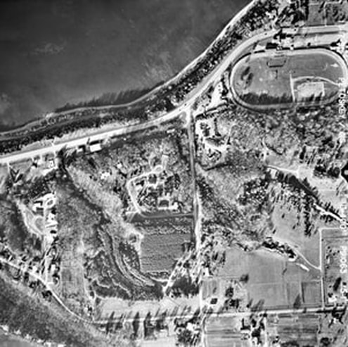
Greenwood Photo Archive Collection from Petoskey newspapers (Undated)
2008 Emmet County GIS Map Below: Square Parcel #400-015 PRE Cemetery Ownership
The riverine area is obvious, and the entire parcel has trees/vegetation.
Adjacent to the north-west line of the #400-015 Cemetery parcel is the County's Fairground Property.
The riverine area is obvious, and the entire parcel has trees/vegetation.
Adjacent to the north-west line of the #400-015 Cemetery parcel is the County's Fairground Property.
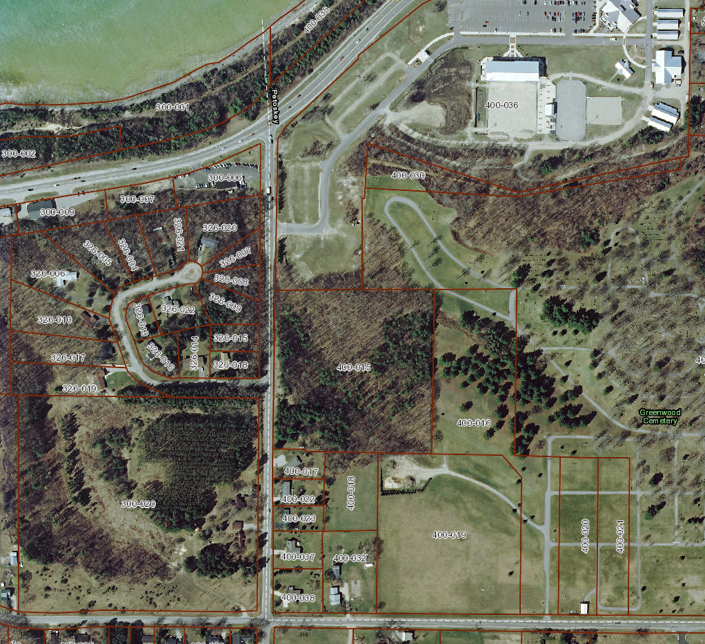
2008 Emmet County GIS Map ~ Square Parcel # 400-015 PRE Cemetery Ownership
2017 Emmet County GIS Map Below: Square Parcel #400-015 Five years after Cemetery Ownership in 2011
The riverine area still is obvious, although filling the riverine has begun,
and the entire parcel already has had the removal of MANY trees/vegetation.
The riverine area still is obvious, although filling the riverine has begun,
and the entire parcel already has had the removal of MANY trees/vegetation.
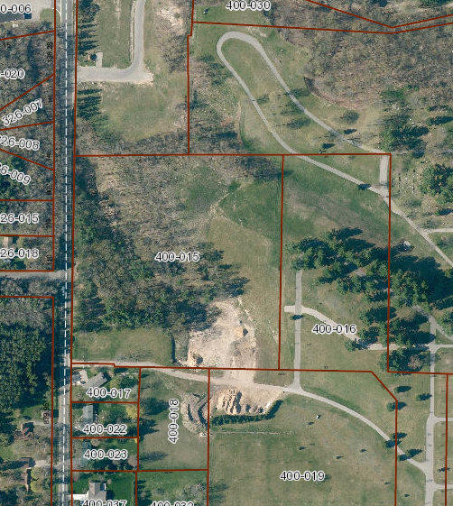
2017 Emmet County GIS Map ~ Square Parcel # 400-015 PRE Cemetery Ownership
Photo Below: taken 7 April 2020 by Charles Dawley and posted only Here with his permission. Interestingly, this photo below of the Cemetery's same #400-015 Parcel was taken just six days before the massive slope failure at the wheelway.

Photo taken 7 April 2020 by Charles Dawley and posted only Here with his permission.
Photo Below: A close-up of the same photo above, making it clear how the trees had been logged off the parcel. Click on the photo to enlarge it for easier viewing.
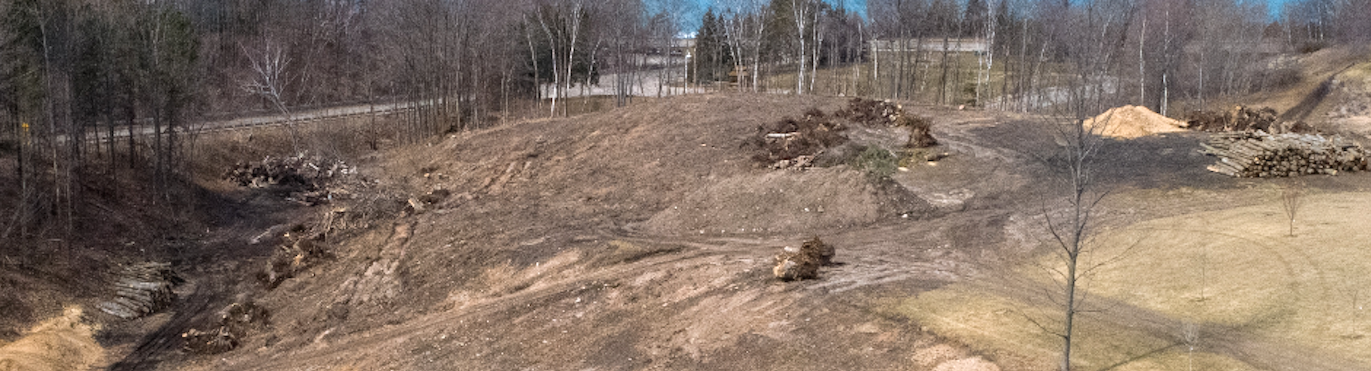
Photo taken 7 April 2020 by Charles Dawley and posted only Here with his permission.
Mr. Reaves, County Administrator had stated at the Baird Study Presentation in response to E.M's public comment:
"I didn’t want anyone to tie one project with this problem that’s a non-starter."
The wheelway slope failure, however, has a DIRECT connection to the County Fairground/Greenwood Cemetery project
(farther below)
if for no other reason than
"A Riverine Runs Through It".
"I didn’t want anyone to tie one project with this problem that’s a non-starter."
The wheelway slope failure, however, has a DIRECT connection to the County Fairground/Greenwood Cemetery project
(farther below)
if for no other reason than
"A Riverine Runs Through It".
Two Photos Below: The city and the county told that these recent ADDITIONAL wheelway washouts have transpired. No particular location was stated, however, in relationship to the original 13 April 2020.
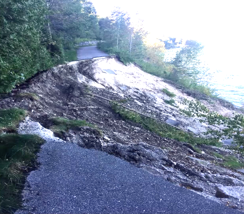
Public Governmental Photo (About 20 September 2020)
|
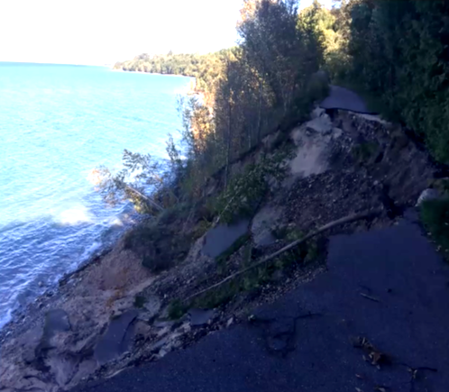
Public Governmental Photo (About 20 September 2020)
|
Again, on 12 October 2020, City Manager Rob Straebel said "there was a 'critical urgent need' for safe trail amenities" as he presented the plan to the county commissioners. Straebel continues to draw the commissioners and their taxpaying constituents into this project... just a bit at a time. Straebel continued, "We're not going to build something with a longevity of 10 years... We're going to build it probably for the next 30,40,50 years or so." [That would be good, considering the recently MULTI MILLION DOLLAR 2020 washed out portion of wheelway lasted only 12 years!]
At the Emmet County Board of Commissioners Committee of the Whole 12 October 2020 meeting, the board passed with a 4-3 vote this motion:
"I move that the Board approve the attached proposal of Beckett & Raeder for an additional study [contract] for an alternative route fo the Little Traverse Wheelway in an amount to cost Emmet County no more than $3,250.00." [That amount being 1/3 of the total with Resort and Petoskey paying the other 2/3 of the total $9,750.00.]
Ordinarily, the Board does not make decisions on money–required motions at COW meetings, but rather those money-spending related motions are decided at the ECBOC regular meetings [This proposal had been presented to the city manager in the form of a letter dated 9 September 2020, even BEFORE the Baird Study was presented publicly to the three entities on 21 September 2020]. So, was all of this process just preordained??? and going-through-the-political motions? How else would Beckett & Raeder have already known that an alternate outcome was a strong possibility for them to propose, as below? That outcome, in reality, could have been determined BEFORE the $81,000.00+ had been spent on the Baird Report which required nothing more than gathering existing information from the internet, and just common sense!
The Beckett and Raeder contract would provide a conceptual design and engineering for investigating and proposing an alternate LTW route, with their stated tasks including:
1. Meet with the three entities to confirm scope and schedule of work.
2. a. Gather available background info (How many times does this need to be done?)
b. Prepare base map from above info (GIS and Property Search has these.)
c. Visit proposed site (Ya think?)
d. Investigate options for easements from property owners
e. Consult MDOT about project (Supposedly, MDOT was already a part of this)
f. Investigate other recreational or opportunities to heighten funding sources (and to add to the cost)
3. a. Prepare conceptual trail route on digital base map, along with Probable Construction Cost
b. Prepare alternative options as necessary
4. a. Meet with three entities to present concepts (Additional service and expense for Joint Presentation to City, Township and County stated in contract... huh?)
b. Present concept to MDOT, and make needed revisions
c. Put final conceptual plan on a 24" X 36" color rendered drawing of conceptual route (COST? Just copy it from the county's GIS map!)
TASK 4 to be completed week of 30 November 2020; decent wage [$81,000.00] for 1 1/2 month timeframe.
2009 Happenings Tell Story of 2020 Involvement!
Photo Below: Location of tracks in old cement plant was moved away from the bay and closer to US 31...
Photo Below: Location of tracks in old cement plant was moved away from the bay and closer to US 31...
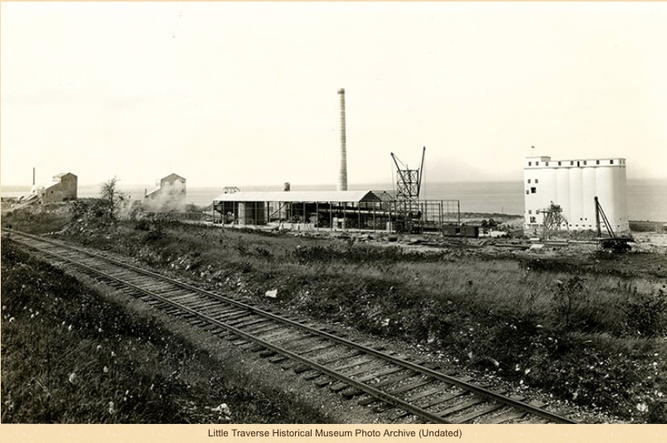
2009 Letter to the Editor Below and Advertisement for the REopening of Resort Township's East Park:
If any taxpayers wonder why they have been drawn into paying for another study regarding the wheelway, then consider the messaging below. Previous to being an Emmet County commissioner, Charlie MacInnis had worked for Consumer's Energy [CMS] when they were heavy into developing a contaminated Bay Harbor. East Park in Resort Township was being REopened after toxic leakage had been discovered. Also, in this 2009 timeframe when the wheelway was to progress on a "rails to trails" route through Bay Harbor, the old railroad track always had lain very close to the bay where the loading docks for the cement plant were located (see photo above). It was to the benefit of the resort to allow the wheelway to be close by, but not right through the Bay Harbor Village; thus the wheelway was constructed close to US 31 going past Bay Harbor, but NOT THROUGH Bay Harbor. How did that movement of track (rails to trails) occur? Charlie MacInnis played a prominent role in the various aspects regarding the wheelway, especially when considering his "Thank you, CMS" letter below which recognizes Charlie, then as "president of the top of Michigan Trail Council", along with "Fred Fettis, chairman of the Little Traverse Wheelway Committee." Such connections make a 2020 "wheelway study no-vote" a hard call, in days of voting as an Emmet County commissioner.
If any taxpayers wonder why they have been drawn into paying for another study regarding the wheelway, then consider the messaging below. Previous to being an Emmet County commissioner, Charlie MacInnis had worked for Consumer's Energy [CMS] when they were heavy into developing a contaminated Bay Harbor. East Park in Resort Township was being REopened after toxic leakage had been discovered. Also, in this 2009 timeframe when the wheelway was to progress on a "rails to trails" route through Bay Harbor, the old railroad track always had lain very close to the bay where the loading docks for the cement plant were located (see photo above). It was to the benefit of the resort to allow the wheelway to be close by, but not right through the Bay Harbor Village; thus the wheelway was constructed close to US 31 going past Bay Harbor, but NOT THROUGH Bay Harbor. How did that movement of track (rails to trails) occur? Charlie MacInnis played a prominent role in the various aspects regarding the wheelway, especially when considering his "Thank you, CMS" letter below which recognizes Charlie, then as "president of the top of Michigan Trail Council", along with "Fred Fettis, chairman of the Little Traverse Wheelway Committee." Such connections make a 2020 "wheelway study no-vote" a hard call, in days of voting as an Emmet County commissioner.
17 August 2009 ~ Petoskey News Review
|
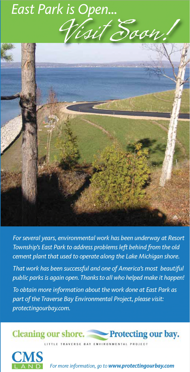
17 August 2009 ~ Petoskey News Review
|
Commissioner Charlie MacInnis has been in "on the groundwork" for the wheelway in this delicate unstable area, even when it was openly known, as documented in SEVERAL records above, that the trailway would be resting on a slippery slope. Taxpayer money/grants/funding needed to flow freely right from the beginning to create the wheelway; no matter that decisions for its location placement were faulty. Charlie has moved on as a county commissioner where he will be asked to approve even more taxpayers' dollars to continue this ill-designed wheelway legacy.
Still at the 12 October 2020 COW meeting several commissioners questioned why the MDOT was not contributing as well. The 14 October 2020 Petoskey News Review reported: "The proposal for the engineering study does call for continual consultation and coordination with the department [MDOT], and Straebel said the solutions proposed in this upcoming study will be based on those conversations... 'MDOT is not going to do anything at this point,' he said. 'They're saying it's incumbent upon Resort Township, Emmet County and the City of Petoskey to develop those plans for their [MDOT's] review.'"
As of 21 October 2020 an MDOT representative has stated that MDOT already commented that users can use the existing US-31 shoulder. "We cannot say it is part of the wheelway because the US-31 shoulder does not meet the standards of a non-motorized path as described in the American Association of State Highway Transportation Officials (AASHTO) standards. In other words, the US-31 shoulder does not meet the width, offsets, buffer zone, etc, for a non-motorized path."
As of 21 October 2020 an MDOT representative has stated that MDOT already commented that users can use the existing US-31 shoulder. "We cannot say it is part of the wheelway because the US-31 shoulder does not meet the standards of a non-motorized path as described in the American Association of State Highway Transportation Officials (AASHTO) standards. In other words, the US-31 shoulder does not meet the width, offsets, buffer zone, etc, for a non-motorized path."
More Damage Following the WINDS OF NOVEMBER 2020
Charles Dawley recorded on 18 November 2020 the new damage on the wheelway.
His revealing videotape may be viewed at Little Traverse Wheelway on You Tube by clicking HERE.
Photos below were taken 18 November 2020 by Charles Dawley
and presented on this web page as a slideshow only with his permission.
The pictures begin on the west end of the wheelway toward Charlevoix, and
follow to the east past the massive slope failure by the overlook washout area.
Click PLAY on the upper left corner, and click any THUMBNAIL photo for instant access.
Compare below, the April 2020 left photo to the November 2020 right photo... it is hard to believe that MDOT does not detect or recognize any upper slope movement that might affect the stability of US31 which runs only about 75 feet above the slope failure as it was in April 2020, at least. Compare the large pieces of "Revetment Stone" that have collapsed since April until November and how much closer the erosion is to the tree line. Perhaps "heads are being buried in the foundation of SAND" regarding the seriousness of a possible US 31 collapse, ignoring historical happenings. This wheelway need not be rebuilt at a waste of taxpayer dollars, but its rapid demise can certainly be used to judge the stability of the roadway above which does need to be attended BEFORE highway tragedy.
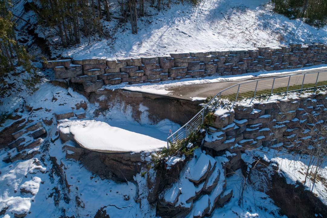
15 April 2020
|
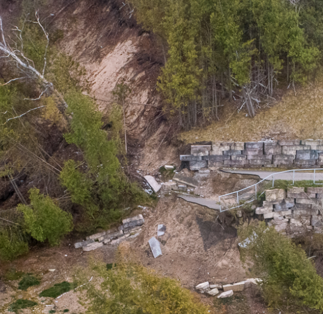
18 November 2020
|
Article Below:
Various "key players" involved in restoring the Little Traverse Wheelway express their views at the end of 2020!
Keep in mind that City Park Director Klinglesmith's wife is associated with the firm Beckett and Raeder,
standing to make money from contracting to plan and design the wheelway.
Various "key players" involved in restoring the Little Traverse Wheelway express their views at the end of 2020!
Keep in mind that City Park Director Klinglesmith's wife is associated with the firm Beckett and Raeder,
standing to make money from contracting to plan and design the wheelway.
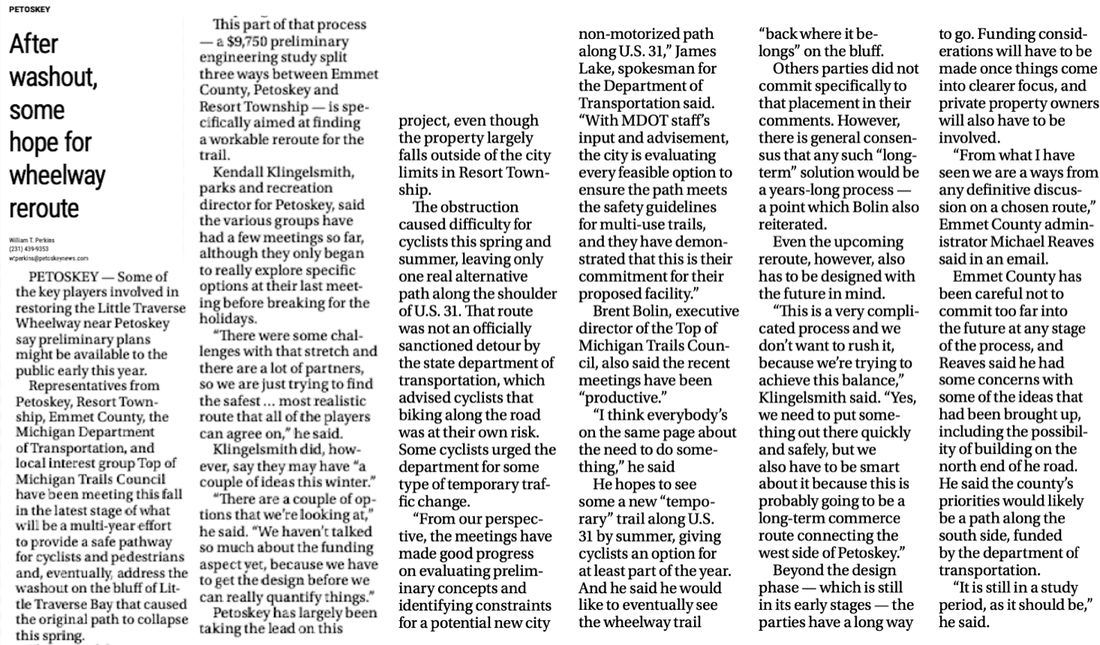
29 December 2020 ~ Petoskey News Review
City Council Meeting Minutes for 4 January 2021 the City Manager Updates included:
"City Councilmembers commented if staff had looked into a Natural Resource Trust Fund grant
to help with Little Traverse Wheelway detour expenses."
"City Councilmembers commented if staff had looked into a Natural Resource Trust Fund grant
to help with Little Traverse Wheelway detour expenses."
9 February 2021 ~ Emmet County Board of Commissioners Meeting Minutes
Map Below: The Petoskey City Council 1 March 2021 Agenda Packet AND the 8 March 2021 Emmet County Commissioners Agenda Packet (both accessible on-line), both include a Report and Conceptual drawings by Becket and Raeder, of both a “north-side” US 31 AND a “south-side” US 31 relocation detour around the damaged sloped areas on the Little Traverse Wheelway.
"The conceptual cost estimate for the proposed trail route on the south side of U.S. 31 ranges from $1,500,000 to $1,700,000. Factors affecting cost for this option include crosswalks and related equipment, utility installation or relocation, and low segmental unit retaining walls. This trail route terminates at the Magnus Park trailhead on Jackson Ave." ~ Beckett&Raeder
Click on the map below to enlarge it for easier viewing...
The north side of US 31 plan is highlighted in RED.
The south side of US 31 plan is highlighted in ORANGE.
Click on the map below to enlarge it for easier viewing...
The north side of US 31 plan is highlighted in RED.
The south side of US 31 plan is highlighted in ORANGE.
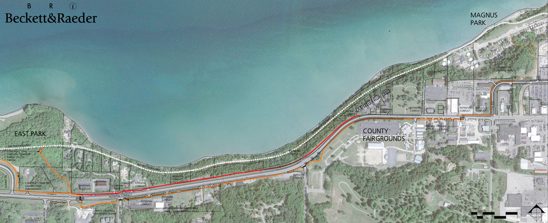
Little Traverse Wheelway Relocation Study Overall Map prepared by Beckett & Rader (Click on the map to enlarge it for easier viewing)
The above map was included with the Beckett&Raeder report which listed many of the concerns with either option, leaning more toward a safer south-side US 31 alternative, thus my following concerns are stated regarding the south-side trail reroute as well.
01) Just a TRUE STATEMENT: Taxpayers already have paid too many millions of dollars for the now eroded wheelway, to be paying forecasted millions AGAIN, for a bike/walking path after so few years of longevity; because of a poorly researched and designed trail section completed in 2008. This statement is made from the fact that GRANTS are NOT FREE, to the taxpayer, unless the grant comes from a non-governmental source.
02) Decisions previously were made with no regard to the historically documented consistently unstable eroding slope; ending with its recent horrific 2020 slope failure of the wheelway location.
03) The suggested slope trail leading up from Magnus Park near to the hospital is especially steep, and of great concern, especially for youngsters on bikes. What entity is liable for injuries anywhere to anyone on the bike trail, per design/engineering, or for non-maintenance?
04) Will Resort Township and City of Petoskey taxpayers pay twice for the proposed NEW trail, because those same taxpayers also will pay through their county taxes if the county were to become involved? What are the funding mechanisms? Why has the county government felt compelled even to become involved in this NEW trail?
05) What entity is responsible for future maintenance (being part of the ultimate price) of a proposed trail? Past property grant easements, within the deeds, stated that Petoskey was responsible for repair of the trail, not the county.
06) ANY trail design and engineering contracts need to be "signed-guaranteed" for a permanent trail; NOT just for a temporary reroute. Forget also about reengineering the present collapsed wheelway by the water. Quit spending money wastefully, and over and over wastefully. IF a trail is created, make it permanent, not a stopgap-short term fix.
07) The main road US 31 pedestrian/bike crossings in the plans lend themselves to danger; a safety issue considering that the Trail Promoters have reported many thousands of bikers have used the trail in the past. This new south-side plan portends additional future tunnelings or overpasses… not figured into this possible project's cost estimates now! Also, stated, “The estimates of 1.5–1.7 may vary when survey work is completed, and underground utilities information is gathered.” Knowledge of FINAL COSTS need to be noted before proceeding.
08) When the south-side route reaches the west end by east Park, “potential future below grade crossing” is noted on the plan. Why not eliminate the dangerous “surface crossings, and build the tunnel as part of the original design? In the same area, why is it necessary to have TWO routes to meet up with the present trail (called “Alternate route constructed through township parcel” AND a route “constructed on Quarry Drive Embankment); no need to expend money for two routes to connect to the same trail. AND, no need to spend money on a completed trail in the beginning, then to spend millions more for a trail which soon will need to be upgraded with tunnels perhaps because of an injury or death due to otherwise unsafe crossing areas.
09) Why be concerned about building farther in the direction of Charlevoix when the present trail cannot get to Charlevoix? Is Charlevoix going to take care of their eroded part of the wheelway? Has anyone asked Charlevoix's plans?
10) It appears in the trail design that plans have been located "outside the MDOT right-of-way". In communication with Matt Radulski Operations Engineer for MDOT out of Gaylord, Michigan on 21 October 2020, he revealed the following… “MDOT does maintain non-motorized pathways in the ROW, we only permit them as long as they meet AASHTO guidelines. Building a trail in the ROW is an option. It is up to a local agency to maintain them and we have agreements for those non-motorized in the ROW. Building a trail by Eppler road, for example, would be tough and more expensive than other areas of the trail, but it can be done.” Perhaps advantages would be had to design/engineer a trail in the ROW even on the south-side to engage MDOT more in the process.
11) The historical example of MDOT on the north side of Petoskey near Sunset Park, recently needing to move the entire roadway away from the eroding bluff area can be related to this south-side US 31 wheelway plan. Does reassurance exist now that US 31 roadway over the washout area near Eppler Road will not begin to erode the very close to the bluff US 31, thus leading to MDOT deciding the roadway must move south, farther away from the bluff, like happened by Sunset Park? Then, would the wheelway by Eppler Road need to be done again? Statements in the Beckett&Raeder plan have been made as such, admitting to a possible future highway erosion as: “Because the bluff on the north side of the highway continues to erode and with limited right-of- way between the edge of the highway and the steep sloped areas along the bluff, project stakeholders concurred that locating the trail on the south side of U.S. 31 was a more practical and sustainable approach.” Just how far south does the wheelway detour need to be constructed to be safe against possible future needed movement of US 31 away from the eroding north slope as well?
This whole roadway moving situation was exemplified with the area just north of Petoskey near Sunset Park where MDOT undertook moving the roadway away from the crumbling bluff in 2017 and 2018. The sidewalk in that Sunset Park area had been shut down for years, and needed to be attended. That Sunset Park area, however, had been resting on more substantial limestone than sand, having been the H.O. Rose Limestone quarry in the late 1800s, but it still necessitated moving the roadway away from the limestone bluff. In the collapsed wheelway area, the wheelway was built on the trains’ tracks which were placed right on SAND, in front of sand dunes, RIGHT NEXT TO THE WATER. So that is the setting where the “rails to trails” promoters placed the 2008 wheelway. Some very poor decisions were made by people whose only interest was building a wheelway, with no regard to the makeup of the foundation of the land, PLUS the known existence of wetlands and riverines on the bluff near Eppler Road above US 31, adds to the excess water problem from above the slope… not just high bay waters.
MDOT needs to be more proactive in the wheelway area. If they suspect they will need to do roadwork, then they can build an accessible wheelway at their expense. Another example of MDOT moving the roadway, and thus an associated wheelway, happened as recently as the proposed moving of the highway, and allowing for the replacement of the current section of Petoskey-Mackinaw Trail near Alanson. A 11 February 2021 PNR article reported the statement, MDOT gave word “that they are willing to construct the trail in the [new] location if we [Emmet County] are able to acquire the land, so it’s a really good time to try to seek this property acquisition.”… for the Alanson area trail “currently, part of the problem was the path diverts once it reaches the area now being considered for purchase, sending cyclists along a path closer to highway traffic"… a safety issue.
Learning from the MDOT with the Alanson trail situation, and Sunset Park's history... the possibility of the eroded slope of US 31 highway near the wheelway, could eventually get closer to the highway, thus requiring MDOT to move the section of highway also away from the bluff. Then, what happens to the proposed new wheelway being located on the south side of US 31? Would the wheelway have to be moved again as well, after just having been relocated?
Plan ahead, based on history and knowledge. Fail to Plan… Plan to Fail!
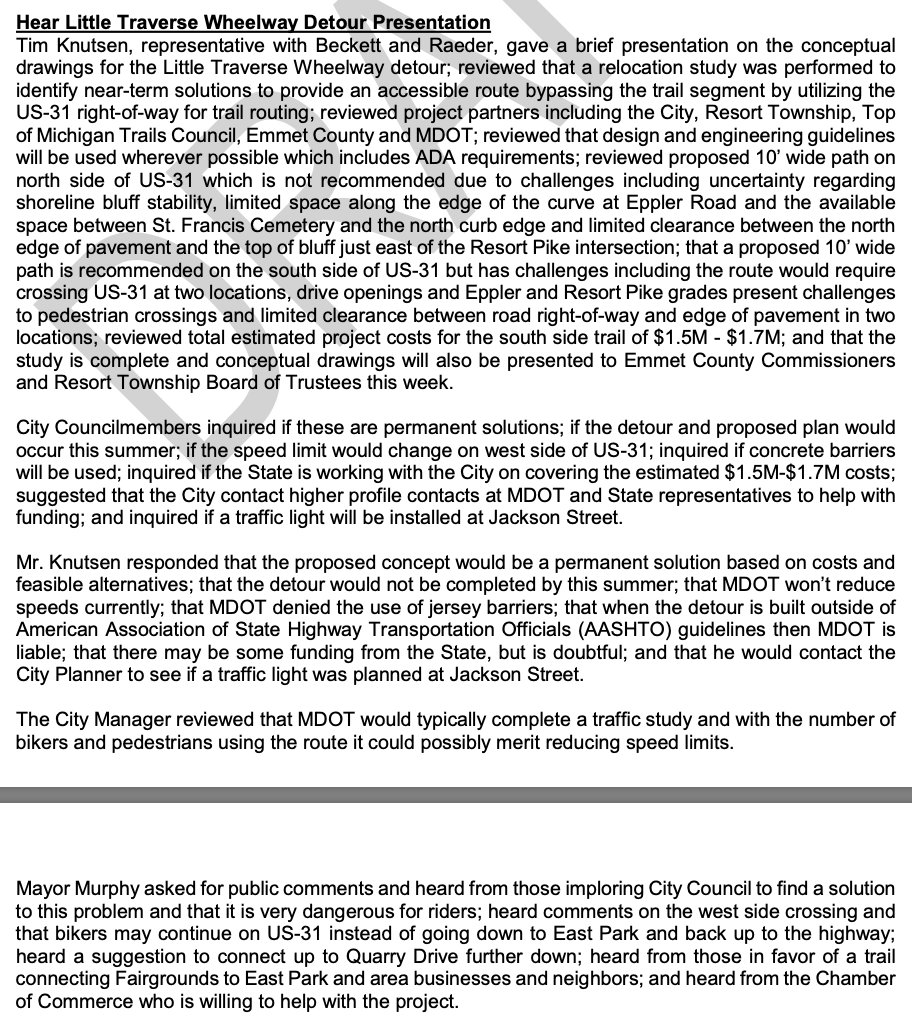
1 March 2021 ~ Petoskey City Council Meeting DRAFT Minutes...
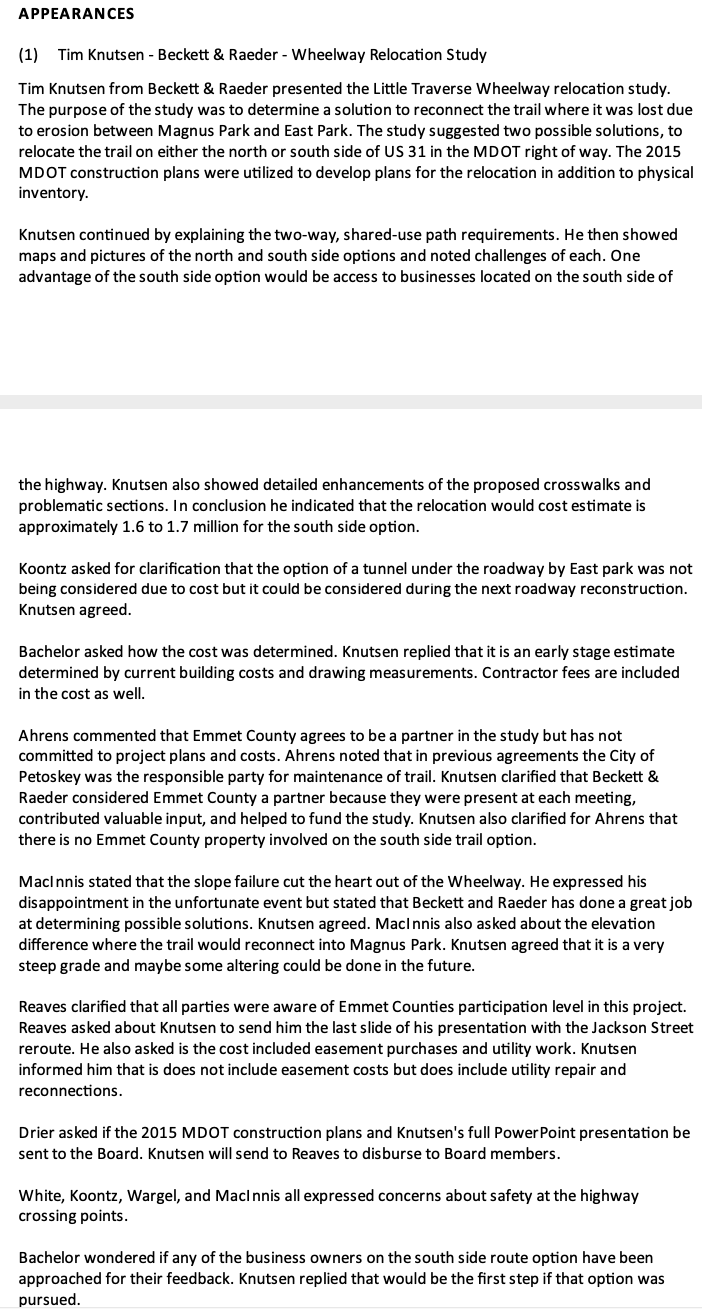
8 March 2021 ~ ECBOC COW Meeting DRAFT minutes...
Reporter Will Perkins, in the 10 March 2021 Petoskey News Review headlined the article: "County officials not fully swayed by wheelway plan." Perkins reported that "Commissioner Neil Ahrens expressed concern about portions of the presentation which listed Emmet County among the 'project partners,' stressing county official had not committed themselves to a partnership on any future steps." As documented in the above DRAFT minutes, all of the commissioners voiced concerns regarding the wheelway plan, and especially the lack of safety with highway crossings was of great concern in the presented plan.
During the 12 April 2021 Emmet County Board of Commissioners Committee of the Whole meeting, Administrator Reaves told that he has been having meetings with Petoskey City Manager Rob Straebel. During that meeting Mr. Reaves told he had been sent photos of the wheelway erosion which he had sent to the commissioners... thus becoming part of the "public domain" to be viewed below in the form of a slide show... click "PLAY" on the upper left corner, or click on the individual photos across the top.
Ninety some thousand dollars worth of "studies" ago by Beckett & Raeder (with OMH Design) could have been eliminated by anyone, or any governmental entity, with an ounce of cents/sense, and any knowledge of the history of the area. This historically erosion-prone area is NOT salvageable as a part of a wheelway... not even by spending the multi-millions that Beckett & Raeder projected for cost to rebuild the eroded wheelway.
So, it seems that the city and Resort Township are moving forward with the production of schematic drawings, with Mr. Reaves stating, "I expect that the BOC will be engaged further in the coming weeks by the City of Petoskey on this project and its next steps forward." The commissioners have not yet approved being a part of the presently proposed wheelway project per se. The last conceptional map presentation of a wheelway beside US 31 to the ECBOC of Beckett & Raeder was prepared by Tim Knutsen, Becket & Raeder's landscape architect.
So, it seems that the city and Resort Township are moving forward with the production of schematic drawings, with Mr. Reaves stating, "I expect that the BOC will be engaged further in the coming weeks by the City of Petoskey on this project and its next steps forward." The commissioners have not yet approved being a part of the presently proposed wheelway project per se. The last conceptional map presentation of a wheelway beside US 31 to the ECBOC of Beckett & Raeder was prepared by Tim Knutsen, Becket & Raeder's landscape architect.
Photo Below included in the slideshow above: Perhaps the push for rebuilding the "lakeshore rebuild of the wheelway" has waned. This viewpoint, however, shows the tip of the wheelway overlook area with the main eroded bank behind, leading up to the road way. IF the MDOT cannot see some sort of SAFETY DANGER with the closeness of the erosion to the Highway US 31 barely through the trees, then MDOT oversight of state roads within Emmet County hangs in safety limbo!
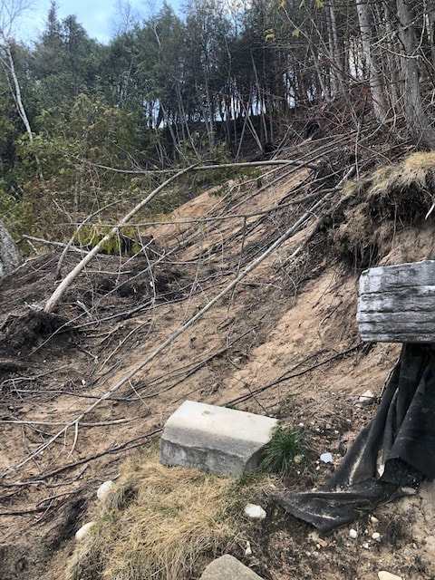
April 2021 ~ Provided by Kendall Klingelsmith to the Emmet County Board of Commissioners into the "Public Domain"

18 November 2020 (Also posted above on this same web page)
Compare the two photos directly above with the red arrow pointing to the same location as in the photo above it. It is easy to notice that more trees have eroded and fallen, and also just how close the erosion is to the highway. MDOT needs to become totally involved in this moving of the highway away from the eroding cliff, and possibly include a space for a safe wheelway in the total MDOT project.
12 April 2021 ~ ECBOC COW Meeting Minutes
The above 12 April 2021 minutes correctly stated that all the county board agreed to was endorsing a "letter requesting appropriations through earmarks from the federal government"... "AS LONG AS THERE IS NO OBLIGATION INVOLVED." The city obviously had other sites set when the city Agenda Memo signed by the city manager and prepared 15 April 2021 for their 19 April 2021 stated:
City of Petoskey Agenda Memo prepared 15 April 2021 for their 19 April 2021 City Council meeting...
A giant "sucking sound" can be heard as the county commissioners become drawn in by the city and township into paying a third of all of the expenses for studies and drawings for an alternate wheelway, for which the commissioners have, so far, not committed.
The Little Traverse Wheelway erosion is visible on Charles Dawley's masterful video which is accessible below.
The Wheelway Washout Summary below is a plea to MDOT to step up and take responsibility for the historically predictable erosion of the area of US-31 located so closely to the collapsed wheelway. It is also a plea to governmental entities, especially the Emmet County Commissioners to base their decisions on a firm foundation; acknowledging the past, and looking down the road. ~ Sent to Matt Radulski (MDOT), county commissioners, county administrator, and county assistant administrator.
The 21 April 2021 Petoskey News Review reported regarding the city's meeting in the headline: "Officials push for tunnel in wheelway detour plans." The article continued, “To a certain extent, there are so many unknowns with the overall cost of the tunnel and signalization,” Straebel said. “I think as we get through the schematic drawings, there will be more and more useful information ... to make better decisions moving forward.” If the schematic drawings are approved by the three entities, well over $100,000.00 total of taxpayer dollars will have been spent for a study leading to the present wheelway being NOT rebuildable. Photos and videos from the April 2020 wheelway collapse should have made any cognizant person aware of that without paying for an $81,000.00 study. Next, a conceptual drawing (actually an overlay from a county type GIS map) was put together by Beckett & Raeder's Landscape Architect showing that Charlevoix Avenue/US-31 ROW on the north side was not adequate for a wheelway and would require the necessity of two pedestrian/cyclist crossing areas which would be very dangerous OR an expensive tunnel in place of at least one crossing area. Now, the city manager THINKS more useful information could be had with new schematic drawings. To be sure, taxpayers can count on the schematic drawing not being the last step before creating an alternate multi-million dollar wheelway.
Could MDOT just step up, and do what needs to be done, so any alternate wheelway is compliant with all MDOT regulations for safety on US-31 for vehicles, pedestrians, and cyclists?
Could MDOT just step up, and do what needs to be done, so any alternate wheelway is compliant with all MDOT regulations for safety on US-31 for vehicles, pedestrians, and cyclists?
The 6 May 2021 Petoskey News Review reported: The city discussed the wheelway at a recent meeting, with City Manager Strabel revealing, the defeat of cost sharing, brings "the planning process to an abrupt halt." The article noted that some commissioners had been frustrated by the lack of MDOT activity involving the wheelway, involving both funding and safety. The city is hoping that the county commissioners will have "a change of heart" for the city and township to then ask the county for a future meeting. Brent Bolin, president of the Top of Michigan Trails Council, an advocacy group promoting the detour "didn't provide any possible alternatives or funding sources, but said the comparatively minor investment in this schematic design now would be the key to attracting more financial backing in the future. 'You get these design engineering documents, and now you have a project that's shovel ready,' he said. 'So you can go to the state and the federal government with hundreds millions of dollars to spend on infrastructure, and we can say 'Here's a project we can do right now that benefits our community.'" Bolin thus appears to have no comprehension of the waste of taxpayer dollars in forging ahead at this point, without PRE-approval from MDOT.
Emmet County Administrator Reaves reports:
10 May 2021 ~ ECBOC Meeting Administrator's Report
The minutes for the 20 May 2021 Emmet County Board of Commissioners meeting regarding the
Appearance of the City of Petoskey's manager Rob Strabel with the commissioners' concerns revealed the following:
Appearance of the City of Petoskey's manager Rob Strabel with the commissioners' concerns revealed the following:
20 May 2021 ~ ECBOC Meeting Minutes continued below...
20 May 2021 ~ ECBOC Meeting Minutes continued below...
20 May 2021 ~ ECBOC Meeting Minutes continued from above...
Two Photos Below:
By 17 May 2021 rip rap was being placed on a bay shoreline in front of property owned by Gustave Lo.
By 17 May 2021 rip rap was being placed on a bay shoreline in front of property owned by Gustave Lo.
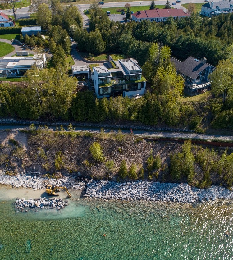
17 May 2021 ~ Charles Dawley (permission to post only on this Northern Mich~Mash Preserve web site).
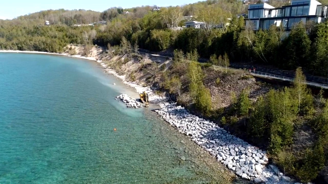
17 May 2021 ~ Charles Dawley (permission to post only on this Northern Mich~Mash Preserve web site).
Minutes of the Petoskey City Council "Comments" for 17 May 2021 included the following referring to the activities shown in the above two photos: "City Councilmember Marshall inquired on the boulders being placed around Arrowhead Shores and who was doing the work and if it was on private property. The City Manager responded that it was a private initiative and all permits were in place."
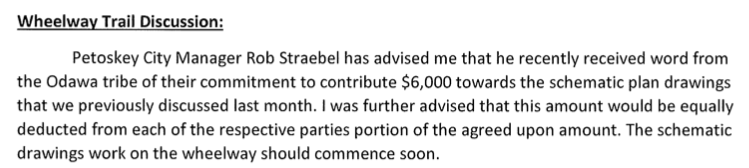
7 June 2021 ~ ECBOC Meeting Administrator's Report
Straebel failed to further explain that the county was "sucked in" with the "cooperative effort" when as Resort Township Supervisor explained in his 29 December 2003 Letter to the Editor posted farther above on this same web page: While Resort Township had qualified for local revenue sharing funding toward the specific purchasing of The Resort Bluffs, and could not just be passed along to another governmental entity. The township even had planned to put in matching funds. The township, however, did NOT qualify for federal and state grants that would be needed to cover the rest of the more than $2 million. So, in 2002 Emmet County submitted similar federal and state grant applications and was approved for much of the money. Thus, the saga for the county "cooperation" has continued incessantly.
By November 2021 City Manager Rob Strabel's own contract with the city had been severed. On 8 November 2021 at an Emmet County Commissioners' meeting, county administrator Mike Reaves reported to the commissioners verbally that he had inquired if the Beckett & Raeder wheelway planners had yet had contact with landowners or business owners along the proposed wheelway route. They replied no. All is being held up by surveyors.
Article Below: Based on Knowledge OR Wishful Thinking??
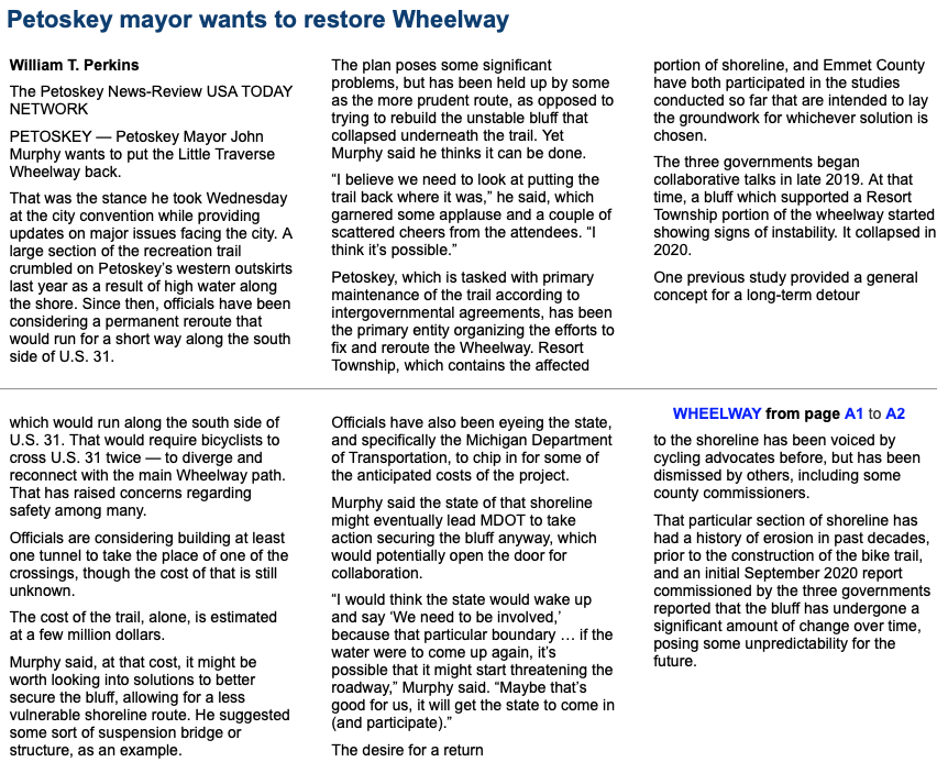
16 July 2021 ~ Petoskey News Review
The Littlefield Grant Application needed to
REBUILD a trail segment near Alanson
IS ILLUSTRATIVE of a
"Failure to Plan" and "Doomed to Repeat."
This should be a LESSON especially to MDOT, under the direction of the Emmet County Board of Commissioners' spending of taxpayer dollars (through grants and other tax dollars), now especially in the washed-out wheelway,
being addressed in the long commentary above.
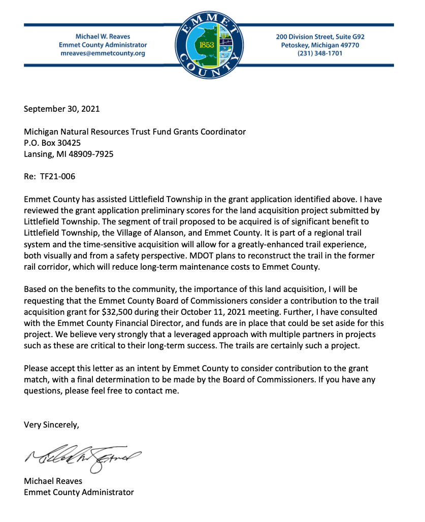
2021 09/30/21 ~ Letter from Emmet County Administrator Michael Reaves to the Michigan Natural Resources Trust Fund Grants Coordinator
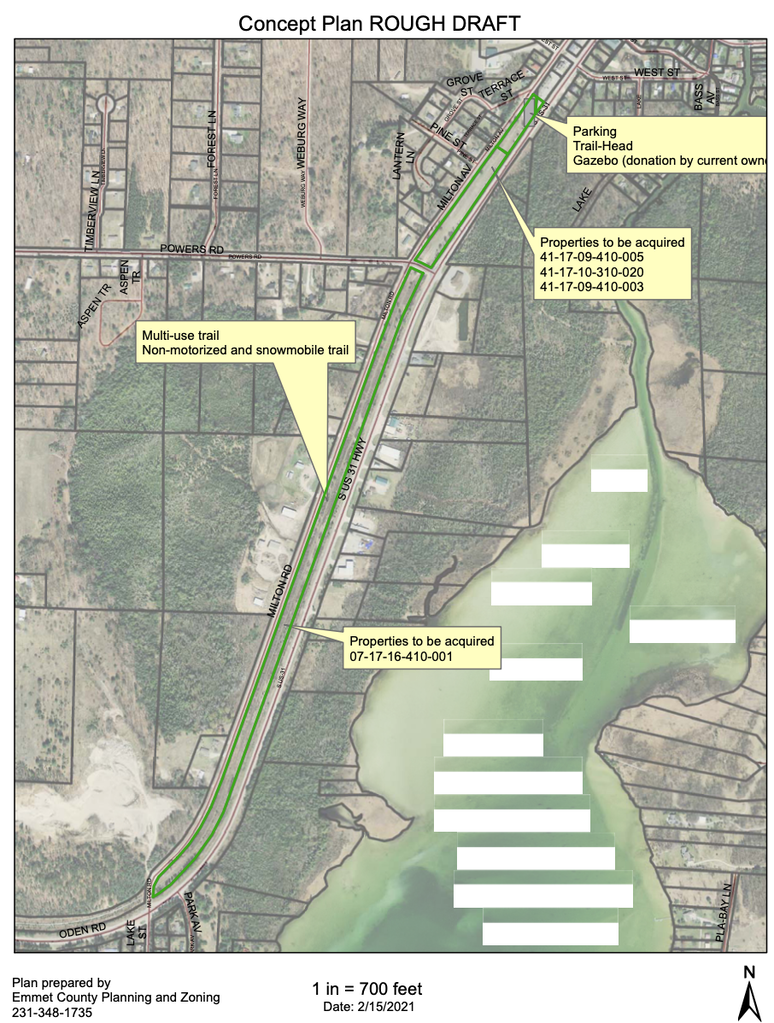
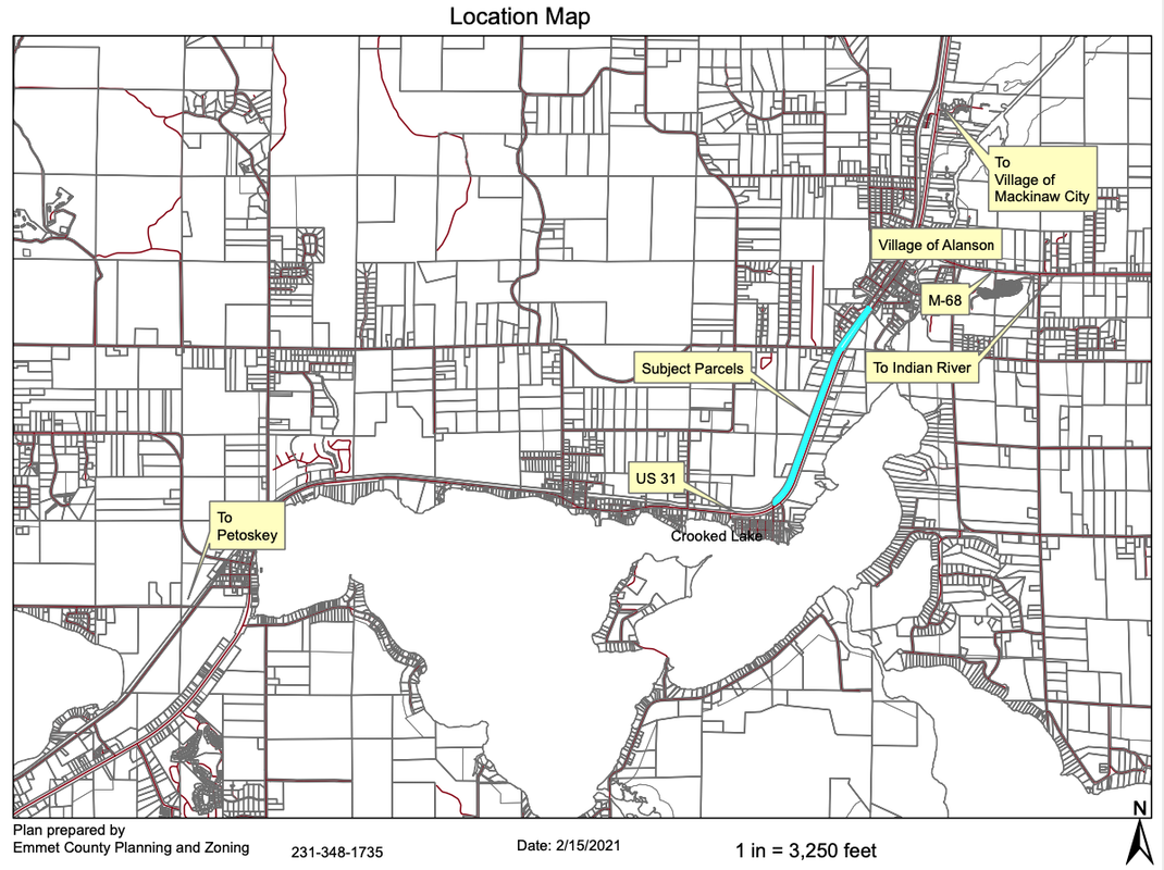
21 October 2021 ~ Emmet County Board of Commissioners
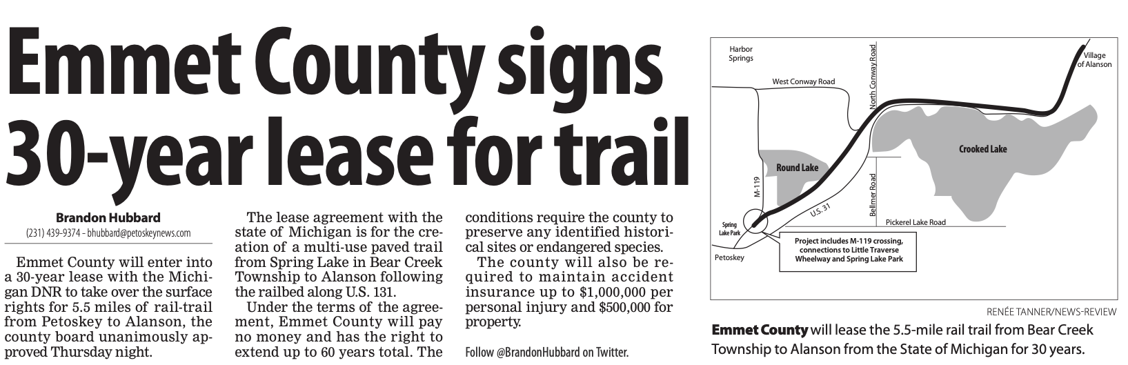
17 August 2012 ~ Petoskey News Review
Consider the 2012 article above for background information in understanding the letter below...
The letter below was written on 20 October 2021 on a topic related to the "redoing of the Alanson segment of wheelway; with the greatest hope that the "governmental-entities-that-be" should learn from past wheelway experiences which should lead to involving judgments which would endure into the future... long-term decisions... eliminating the expenditure of tax money spent over and over for the same project.
~~~~~~~~~~~~~~~~~~~~~~~~~~~~~~~~~~~~~~~~~~~~~~~~~~~~
Below was Sent by Karla Buckmaster
Petoskey
10/20/21
TO: Emmet County Board of Commissioners, Administrator Mike Reaves, Assistant County Administrator Boyer, and Clerk Kanine for inclusion of this communication into ECBOC minutes for 21 October 2021,
1) ECBOC approved 11 October 2021 “to contribute $32,500.00 to the North Western State Trail acquisition grant… to match the funds contributed by Littlefield Township. This contribution would leverage a land acquisition of $1.24 million (taxpayer dollars).” In 2014, at least $1.5 million then was used involving this same section of land. Now, just seven years later, over a million dollars more is needed for the MDOT to rectify this same section by moving the trailway farther away from US-31.
2) In 2017 and 2018 the MDOT undertook moving the state’s US-31 roadway away from the crumbling bluff at Sunset Park just north of Petoskey costing millions of dollars, and a summer, or more, of road closures.
3) Administrator Reaves is reporting for the 21 October 2021 ECBOC meeting that Beckett & Raeder’s project schedule for Wheelway trail work has been setback due to delays in the survey completion portion of the project. I certainly hope you commissioners will not allow this set back to require any additional funding.
~~~~~~~~~~~~~~~~~~~~
Learning from the MDOT ineptness with the 1) Alanson trail situation, and also 2) Sunset Park's roadway history... The possibility exists that the eroded slope of US-31 highway near the washed out wheelway could eventually get even closer to highway US-31, thus requiring MDOT to require future moving of the highway; very reminiscent of “1) and 2)” above. Then, a possible new wheelway, PLUS, especially, the section of actual US-31 highway, BOTH also would need to be moved farther away from the bluff. So, what would happen to a new proposed wheelway being located on the east side of US-31 right next to the present US-31 as in any Beckett & Raeder plans shown thus far. Would the wheelway have to be moved farther east AGAIN, as well, like “1) and 2)” after just having been relocated?
Regarding the present washed out wheelway, Emmet County Commissioners already have approved spending, with the city, and Resort Township, over $100,000.00 for a wheelway study/plan to be located east, albeit, right next to the present US-31 highway; a plan by a “landscape” architect to design a wheelway repair, which will cost MILLIONS MORE dollars, on top of the useless MILLIONS spent for the original engineered wheelway FAILURE.
Numbers 1) and 2) above have already transpired. You ECBOC, however, NOW have the opportunity to use foresight, not “1) AND 2)” hindsight, in securing a future route for the repair of the Little Traverse Wheelway a wise distance, far enough, to the east of US-31 in the “Washout Area.” So, even when the MDOT finally wisely agrees, for safety, they must move the highway away from the eroding bluff, you ECBOC already will have acted to place the wheel way repair much farther to the east of US-31, not just have waited to react and spend more money!
Get the MDOT involved FULLY NOW. The MDOT will make the final plans anyway regarding the wheelway and the highway, so why spend any more money on hypothetical local plans? Do not wait for the MDOT to quit dragging their feet… use your voice leverage and our taxpayer dollars wisely… whether state or county funds. You represent the VOICE of Emmet County’s taxpayers…
Plan ahead, based on history and knowledge.
Fail to Plan… Plan to Fail!
The arrow in the photo below points out the closeness of the top of the wheelway washout to highway US-31. The car is headed easterly to give orientation. The photo was taken 15 April 2020 after the washout, with permission to post here by Charles Dawley of Up North Imagining.
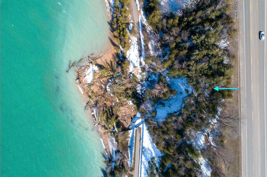
15 April 2020 ~ Charles Dawley (permission to post only on this Northern Mich~Mash Preserve web site).
Although the above letter was written on 20 October 2021 to the ECBOC and to the county clerk and asked to be placed into the Emmet County minutes, it was not... UNTIL the clerk was asked again and she conferred with Administrator Reaves; and then the letter was included in the minutes for the 21 December 2021 minutes as Attachment #6.
A 26 January 2022 Petoskey News Review article gave a forewarning to the county, state, and federal taxpayers... "Issues on the Menu: Public Transit, Broadband in Infrastructure Bill Allocations." Issues that Emmet County communities have been clamoring about like public transportation, water contamination, broadband internet access and deteriorating roads and bike paths, may likely find funding this year through the "Infrastructure Investment and Jobs Act" which will give access to BILLIONS of dollars for the state of Michigan to spread around the counties, through the Michigan Department of Transportation, the departments rural task force, and local metropolitan planning organizations. The money can go toward local governments, as well as local tribal government. Emmet County has had a failed transit program, which could be reinstitute with use of this new funding... with an authority. When this initial funding, if used for transit is gone, then the taxpayers will be coerced into more taxes to continue the expected service. A 26 January 2022 Petoskey News Review article gave a forewarning to the county, state, and federal taxpayers... "Issues on the Menu: Public Transit, Broadband in Infrastructure Bill Allocations." Issues that Emmet County communities have been clamoring about like public transportation, water contamination, broadband internet access and deteriorating roads and bike paths, may likely find funding this year through the "Infrastructure Investment and Jobs Act" which will give access to BILLIONS of dollars for the state of Michigan to spread around the counties, through the Michigan Department of Transportation, the departments rural task force, and local metropolitan planning organizations. The money can go toward local governments, as well as local tribal government. Emmet County has had a failed transit program, which could be reinstitute with use of this new funding... with an authority. When this initial funding, if used for transit is gone, then the taxpayers will be coerced into more taxes to continue the expected service.
This new source of FREE funding for bike paths as noted above, MUST NOT encourage the "powers-that-be" to willy-nilly vote to replace the eroded wheelway just because money is available in a large amount. They must learn from the past wheelway area failures and not REbuild in the riverine-washout area so close to the bay. They must get the MDOT involved, as part of the engineering design, with a possible movement of US-31 farther from the bay bluff that is so subject to instability and erosion. Engineering of the roadway, and the wheelway, smartly and safely, IF they are planning to use the "Infrastructure Investment and Jobs Act" money in this regard, is imperative.
This new source of FREE funding for bike paths as noted above, MUST NOT encourage the "powers-that-be" to willy-nilly vote to replace the eroded wheelway just because money is available in a large amount. They must learn from the past wheelway area failures and not REbuild in the riverine-washout area so close to the bay. They must get the MDOT involved, as part of the engineering design, with a possible movement of US-31 farther from the bay bluff that is so subject to instability and erosion. Engineering of the roadway, and the wheelway, smartly and safely, IF they are planning to use the "Infrastructure Investment and Jobs Act" money in this regard, is imperative.
Just prior to the above 26 January 2022 announcement of "Infrastructure Investment and Jobs Act" funds for bike paths, on 24 January 2022 a meeting was held to update the parties (City of Petoskey, Emmet County, Resort Township) involved in the Beckett & Raeder Schematic Design Progress–phase III work on an alternative south-side wheelway route. While NO “Opinion of Construction Cost” was included in the presentation, the following information identifying “Challenges to Design Implementation” was presented for the possibility of constructing a trail bypass for the section of collapsed Little Traverse Wheelway, utilizing the south-side US–31 Right-of-Way:
This south-side US–31 option was chosen because of 1 )Concern regarding shoreline bluff stability 2) Lack of available clearance from roadway 3) Preliminary cost.
South Segment Challenges:
1) US–31 Roadway crossings including a proposed pedestrian tunnel crossing near East Park, and a surface pedestrian crossing near Jackson Street
2) Existing Utilities
3) Existing Stormwater Patterms
4) Physical Obstacles: 1) Limited property, need for easements 2) Signs, light poles, and site furnishings
5) Driveway and Side Street Crossings: Steep Slopes
Tunnel Crossing - Design & Engineering Challenges:
1) Proposed retaining walls and clearance to roadway
2) 3’5” minimum depth of cover from tunnel ceiling to finish roadway grade
3) Protect existing 72” storm sewer from impact
4) Re-route utilities over/under tunnel and ramp structures
Existing Utilities - Design & Engineering Challenges:
1) Proposed tunnel will necessitate utilities relocation
2) South Right-of-Way occupied by communication, gas, electric, sanitary, and domestic water. Trail is proposed on a fill embankment in all locations in order to minimize or eliminate utilities impact.
3) Stormwater system redesign to facilitate fill placement for propose trail may necessitate utility revisions.
Existing Stormwater Patterns - Design & Engineering Challenges:
The plan proposes filling or regrading of the roadside drainage swale on the south side of US-31 between west of Comfort Keepers to west of Resort Pike in order to facilitate trail placement.
1) Drainage capacity of existing stormwater facilities within US–31 must be maintained.
2) Stormwater system redesign to facilitate fill placement for proposed trail may necessitate utility revisions.
(Includes a Stormwater Contribution Area drawing (see down below)… is this the same as “riverines”?)
Physical Obstacles - Design & Engineering Challenges:
1) Limited physical property within the road Right-of-Way will necessitate the following easement in specific locations:
1) Temporary construction/grading easement
2) Permanent trail easement
3) Sign relocation
4) Utilities surface structures raised to finish grade
Driveway and Side Street Crossing - Steep Slopes:
1) Slopes of streets and driveways connecting to US–31 where proposed crosswalks are necessary to complete the trail route exceed ADAAG in most locations, ranging from 3% to 10%. Aside from occupying the paved shoulder to relieve cross-slopes, it would appear an exception to the ADAAG would be required for these street and driveway crossings.
Project Completion and Presentation:
1) Complete plan, estimate and revisions and circulate to project team February 7 [2022] ~ Remember that on 1 March 2021 Beckett & Raeder stated, "The conceptual cost estimate for the proposed trail route on the south side of U.S. 31 ranges from $1,500,000 to $1,700,000".... "Factors affecting cost for this option include crosswalks and related equipment, utility installation or relocation, and low segmental unit retaining walls." So one must ask what will be the magical FREE money estimate for the same plan by 7 February 2022.
2) MDOT preliminary plan review
3) Present Plans to Community
Beckett & Raeder Map Below was included in the Schematic Design presentation note above: The multiple riverines area which has cursed the wheelway from the beginning of time, is somewhat being acknowledged as a "stormwater contribution area." The on-line topographical map below features in light-blue dotted lines of the actual riverines.
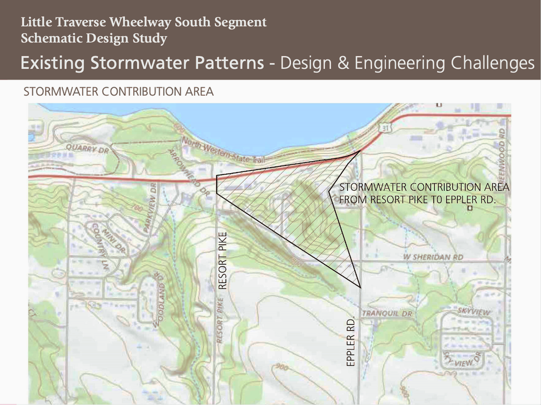
Beckett & Raeder Schematic Design Progress–phase III work on an alternative south-side wheelway route (presented 24 January 2022)
Article Below: The 8 June 2022 Petoskey News Review Article stated that the estimated cost of the proposed segment is $6,491,853.00. It is not noted IF this amount includes the two tunnels which would make the proposed segment safe with road crossings.
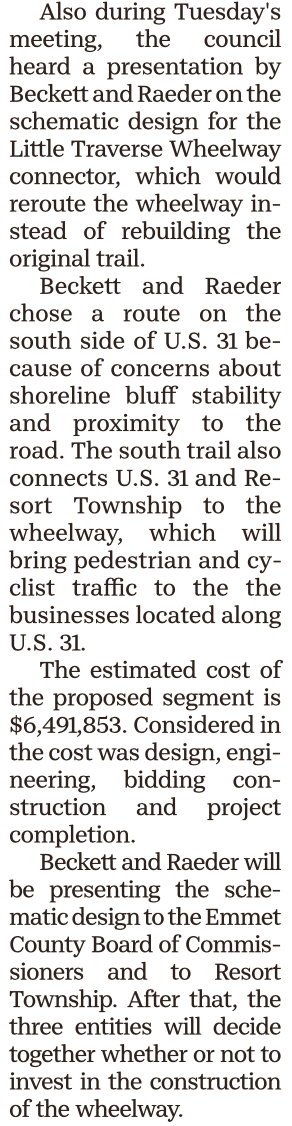
8 June 2022 ~ Petoskey News Review
TOP
The wheels are turning... to rebuild the failed wheelway which lasted only from 2008 to 2020 in the original spot in that very same location. The Resort Township board voted 4-0 in favor to "return the LTWW to its original location from East Park to Magnus Park along the lakeshore, following Bob Wheaton's motion. They call it a less complicated and safer route with easements already in place. Was nothing learned from the past? That slope failure was not a "once in a lifetime" expensive catastrophe.
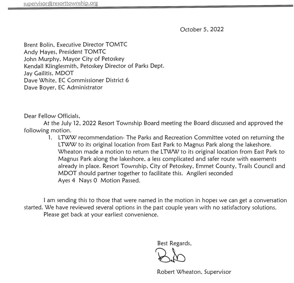
5 October 2022 ~ Composed by Bob Wheaton, Resort Township Supervisor
The following was presented to the ECBOC at the 20 October 2022 meeting at the same meeting the above letter was included in "communications" for that 20 October 2022 meeting:
"A reminder for your future decision making please… You authorized an “up to” $62,500 Facility Condition Assessments evaluation; concluding about $60 million county dollars were needed to repair and maintain our already established county facilities. Maintenance of county assets are mandated! Mandated. Yes… you said you would set aside some of the precious ARPA funds for this. Please remember these mandated needs, and get plans made soon, that reflect the county’s funding of these facility necessities. This actually should happen before considering any NON mandated topics brought before you.
You consistently have various groups asking for ALL of your constituents to fund NON-mandated… yes, NON-mandated, services such as transit, housing, and recently, those wanting the wheelway restored on its original washed out failing slope… even ignoring the over $100,000.00 of tax funded wheelway studies for other wheelway options.
Most of the public has been led to believe that to restore the failed trail only requires addressing the massive wash out as always pictured with the news articles, as if that image represents the total failure; leaving some to suggest… simply just build a bridge over it. Do you realize, however, that the trail that leads from that massive failure, all the way to East Park, has massive slope and wheelway failure? About 3/4 additional mile is so washed out that nothing, except air, remains below the missing trail.
Spend county tax dollars wisely. Pay for county mandated items FIRST.
Do notice the trail pictures that I also have attached. I ask that Clerk Kanine can attach the pictures to the minutes with my public comment." ~ Karla Buckmaster
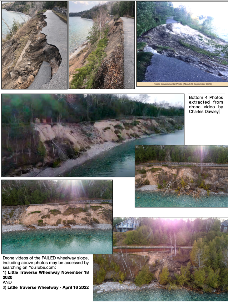
Accompanied the public comment presented to the ECBOC on 20 October 2022
~ 2023 ~
On 1 May 2023 several (maybe 4 or 5) Michigan Department of Transportation [MDOT] vehicles were pulled off the highway, even on to the bluff area, near Eppler Road with several workers. On 2 May 2023 the MDOT directly stated that “MDOT is helping the City of Petoskey by installing monitoring wells and instrumentation within MDOT highway ROW, as part of a larger evaluation by the City of Petoskey to evaluate slope stability along the entire stretch to assist in deciding the best way to re-establish a non-motorized path from Magnus Park to East Park. MDOT readings of the existing instrumentation have indicated no apparent movement of the slope. MDOT communications with the trailway people (city) have related their desire to re-establish a connector between Magnus Park and East Park…. Monitoring wells more or less monitor where the water table is. Other instrumentation monitors slope movement. It is not known the exact feet of the last washout to the edge of the highway shoulder other than to say, the roadway is not in any danger, but it continues to be monitored.”
Only a couple of days after MDOT had been involved as MDOT directly stated above, the 5 May 2023 Petoskey News Review reported: "City manager Shane Horn cautioned against 'skirting around people, going to the other folks higher in the chain' at the Michigan Department of Transportation (MDOT). This is obviously a balance because we have to have a partnership with MDOT and they've been a good partner overall. But I understand and hear the concerns and certainly safety is a big concern. We have talked about potentially working with owners, whether it's the county or others, to expand or extend the shoulder to get people more off the roadway... but unfortunately we're going to be using the same system that we've used in the last couple summers at this point, unless we work with our state legislators to help us in this effort.'"
With city manager Shane Horn's statement above, is he inferring that the "trail group" "skirted around people [the city] going to the higher up MDOT”?
With city manager Shane Horn's statement above, is he inferring that the "trail group" "skirted around people [the city] going to the higher up MDOT”?
It was reported by WPBN on 27 July 2023 that the City of Petoskey received an $800,000.00 grant to restore the eroded Little Traverse Wheelway. The grant comes from the Michigan Department of Environment, Great Lakes, and Energy [EGLE], with an extra $50,000.00 from the Michigan Trails Fund. The Top of Michigan Trails Council will use the money to reconstruct the failed path where it is and ensure disaster never strikes again. Top of Michigan Trails Executive Director Brent Bolin was quoted, "We can build it is a way that follows the new contours, and it can be engineered in a way so that there's less ways for it to fail.... By not having that built up, by following the natural topography and addressing the drainage, we think we can remove many of the conditions that contributed to this failure." Bolin added that with the EGLE grants and others, the project is 85% funded.
So, what does that mean the Trails Council estimates the projected total cost?
So, what does that mean the Trails Council estimates the projected total cost?
Regarding the same $800,000.00 grant as reported above, on 26 July 2023 Petoskey News Review's reporter Karly Graham wrote "the city is partnered with the MDOT, Resort Township, Bear Creek Township and Emmet County to work to fix the popular and scenic section of the Wheelway that failed in 2020 due to erosion.” When Bear Creek Township Supervisor, and Emmet County Administrator were asked, WHEN this partnership has happened, the supervisor said he had "no idea what they are talking about" and the county administrator stated any partnership has not happened. When the township supervisor asked the Petoskey City Manager about any "partnership" with the other governmental entities admitted he must have given the reporter, who just called on the phone, the wrong impression. When the reporter was asked to please write a corrected article, she did not reply, nor retract her reporting with the incorrect information about any partnership regarding the Little Traverse Wheelway Repair.
Last November 2022 Petoskey submitted a grant to the Michigan Department of Environment, Great Lakes and Energy [EGLE] for 100% design and construction drawings for a plan to rebuild the Little Traverse Wheelway and stabilize a mile long section of 120 foot high coastal bluff along the Little Traverse Bay. The city was recommended funding of an $800,000 grant with a $200,000 local match (a 2024 budgeted Capital Improvement Plan item) pending the approval of the grant agreement. City Manager Shane Horn was asking the City Council to consider a motion to approve the grant agreement, and for him to be designee to serve as the City's representative for this project.
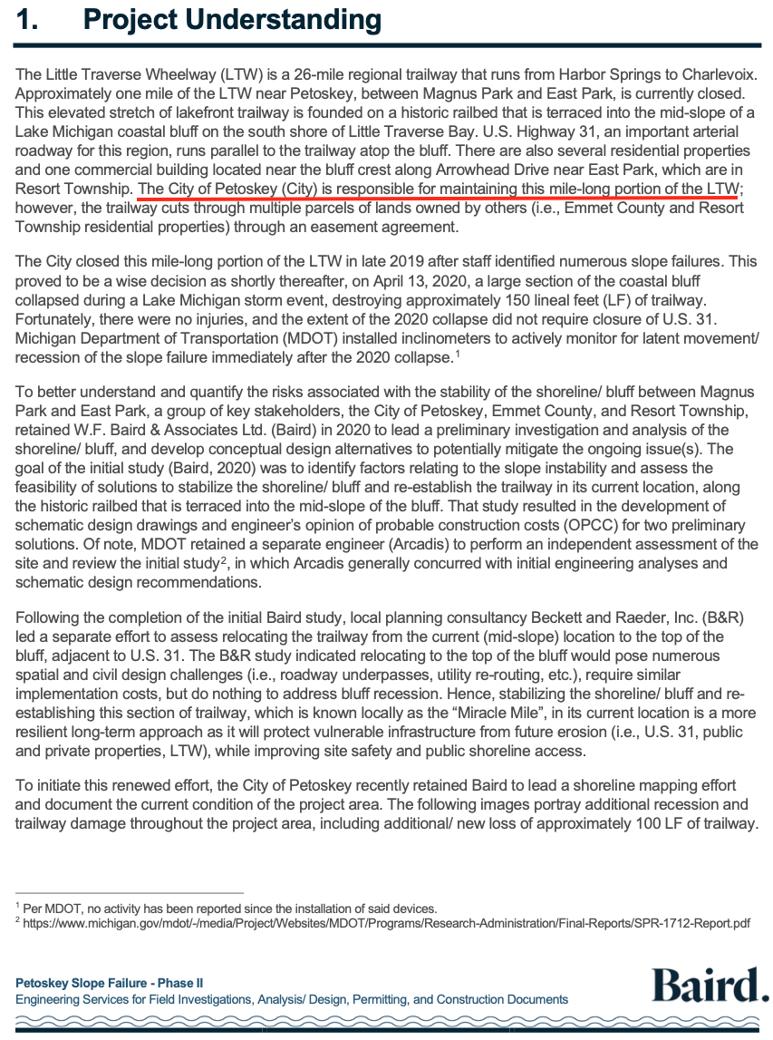
Petoskey City Council Packet for 21 August 2023 Petoskey City Council meeting
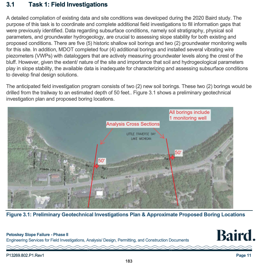
Petoskey City Council Packet for 21 August 2023 Petoskey City Council meeting
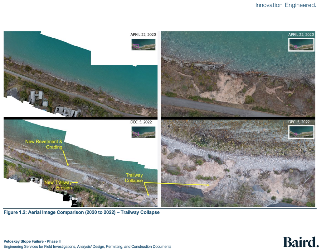
Petoskey City Council Packet for 21 August 2023 Petoskey City Council meeting
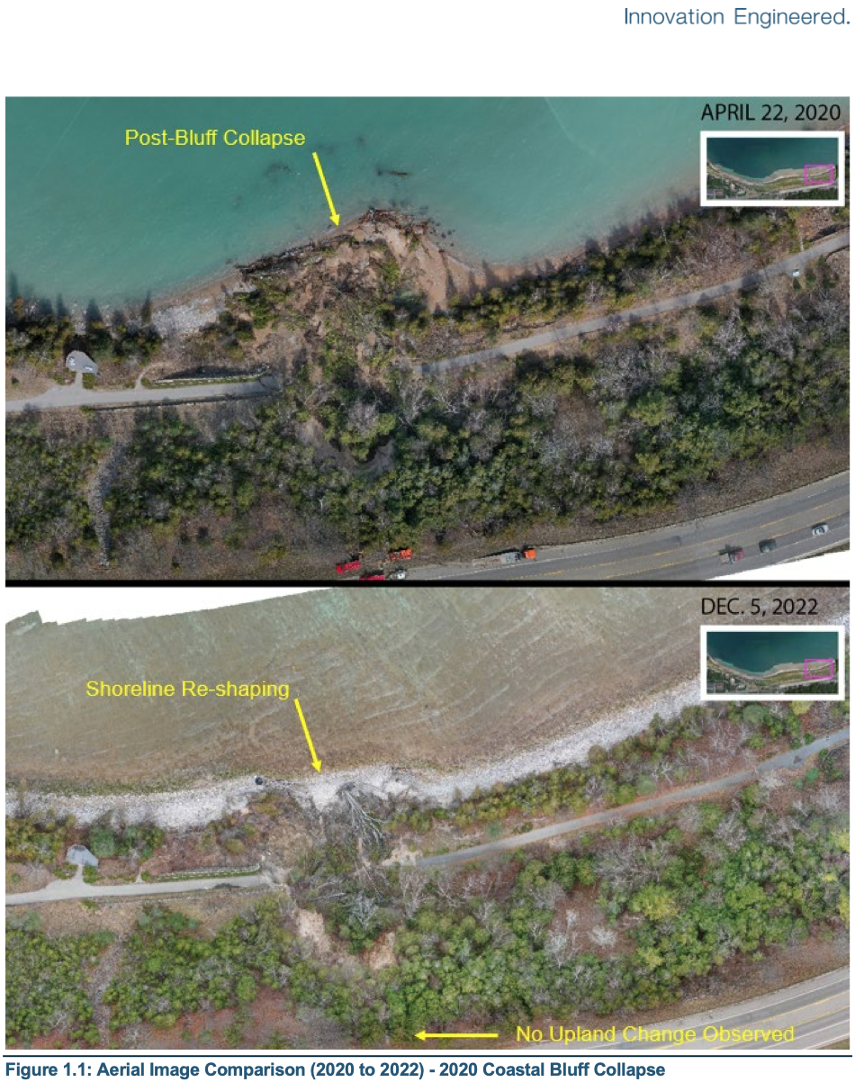
Petoskey City Council Packet for 21 August 2023 Petoskey City Council meeting
Below Photo from Petoskey City Council Packet:
IMPORTANT ACKNOWLEDGMENT is stated of "Observed Groundwater Discharge".
IMPORTANT ACKNOWLEDGMENT is stated of "Observed Groundwater Discharge".
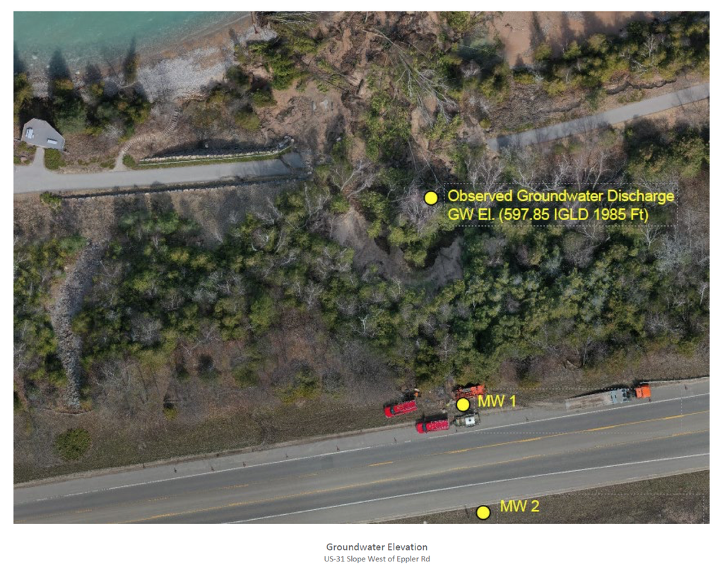
Petoskey City Council Packet for 21 August 2023 Petoskey City Council meeting
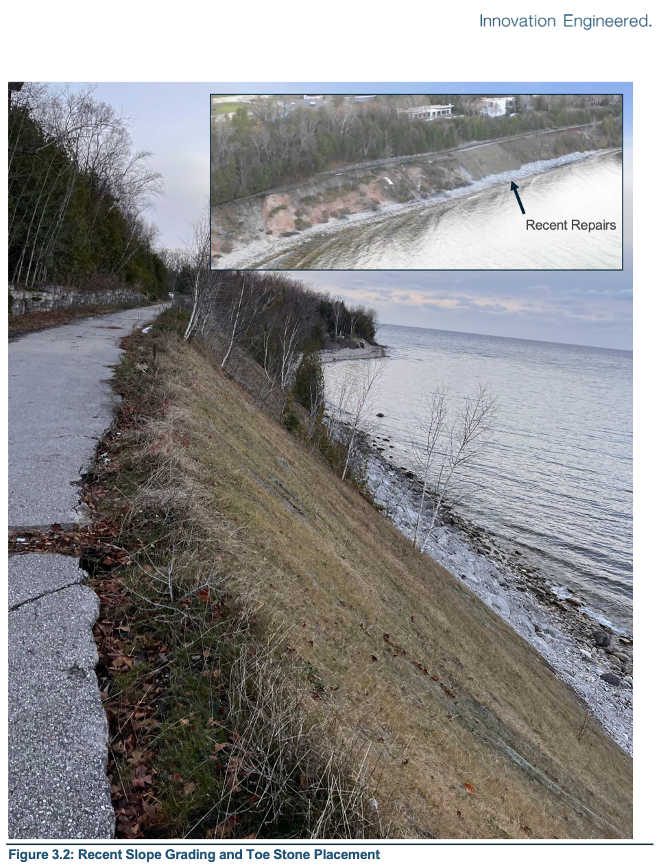
Petoskey City Council Packet for 21 August 2023 Petoskey City Council meeting
Petoskey City Council Packet for 21 August 2023 Petoskey City Council meeting
Petoskey City Council Packet for 21 August 2023 Petoskey City Council meeting
Petoskey City Council Packet for 21 August 2023 Petoskey City Council meeting
The 21 August 2023 Petoskey News Review reported about the Petoskey City Council's meeting: "According to agenda materials, the scope of the grant will provided the city with 100 percent design and construction drawings for a plan to rebuild the Little Traverse Wheelway and stabilize a mile long section of 120-foot high coastal bluff along the Little Travers Bay. the city has been recommended funding of $800,000 through the grant program with a $200,000 local match, pending the approval of the grant agreement... Klingelsmith said, 'This is money specifically to get us to that biddable document with drawings and costs. That's what this grant will be funding."'
City officials and council members stressed that the FIRST priority is addressing the issue of slope stability. Councilman Brian Wagner said, "That's safety, security... That's making sure we don't have issues up on the highway, with housing and so on."
The council went on to authorize a contract with W.F. Baird and Associates Ltd. of Wisconsin, for engineering services associated with construction documents and probably costs for reconstruction of the Little Traverse Wheelway. The contract included engineering services for field investigations, analysis/design, permitting and construction documents for the Little Travers Wheelway in the amount of $1,010,200 (spending over the grant amount, even with the local match).
Klingelsmith admitted, "The trail likely is the easy part. It's everything else to mitigate the water table to understand the subsurface to really try to create a product that will withstand every foreseeable water condition we have. The high water will come back."
Below is a different cemetery topic, but very related to the wheelway topic above...
Greenwood Cemetery and the County Fairgrounds Properties on the Riverine!!!
Photo Below:
Greenwood Cemetery is extending a new section toward Eppler Road in the riverine ravine;
by filling from contractors' waste, grading, and tree removal,
to be followed by reseeding and planting of trees again.
This is the same riverine that contributes to the Wheelway Washout.
Greenwood Cemetery is extending a new section toward Eppler Road in the riverine ravine;
by filling from contractors' waste, grading, and tree removal,
to be followed by reseeding and planting of trees again.
This is the same riverine that contributes to the Wheelway Washout.
Photo taken 7 April 2020 by Charles Dawley and posted only Here with his permission.
Compare the 1994 photo below to the above 2020 photo above of the riverine area showing the amount of trees and vegetation that have been removed directly in the path of the riverine that contributes to the washouts on the wheelway. Trees and vegetation can help to lessen the damaging impact of riverines.
Greenwood Photo Archive Collection from Petoskey Newspaper (1994)
Below: 20 May 2020 Cemetery Proposal for the Emmet County Board of Commissioners to consider.
This is the letter that parts were quoted a bit farther above.
This is the letter that parts were quoted a bit farther above.
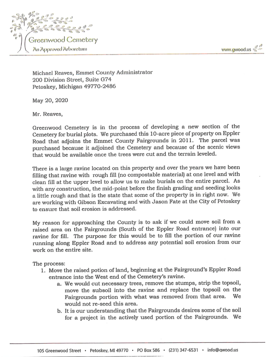
20 May 2020 Page 1 of Cemetery Proposal for the Emmet County Board of Commissioners to consider.
|
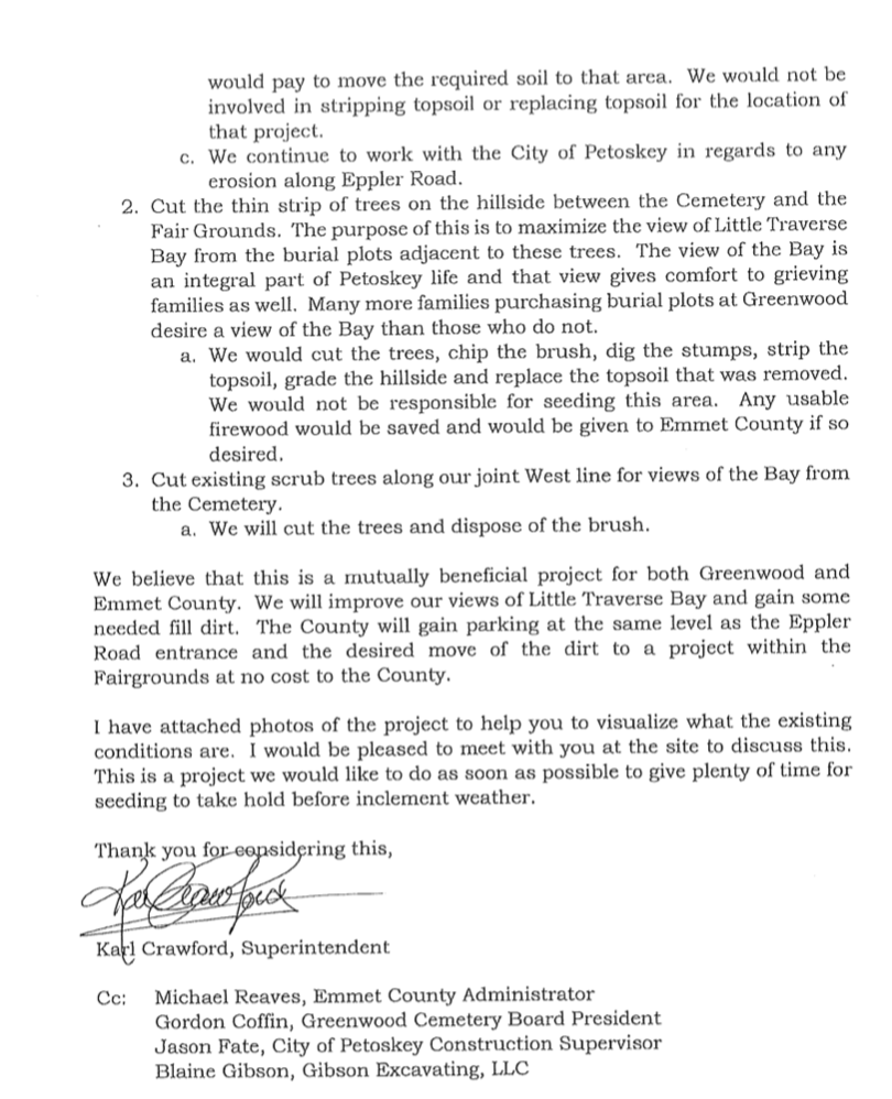
20 May 2020 Page 2 of Cemetery Proposal for the Emmet County Board of Commissioners to consider.
|
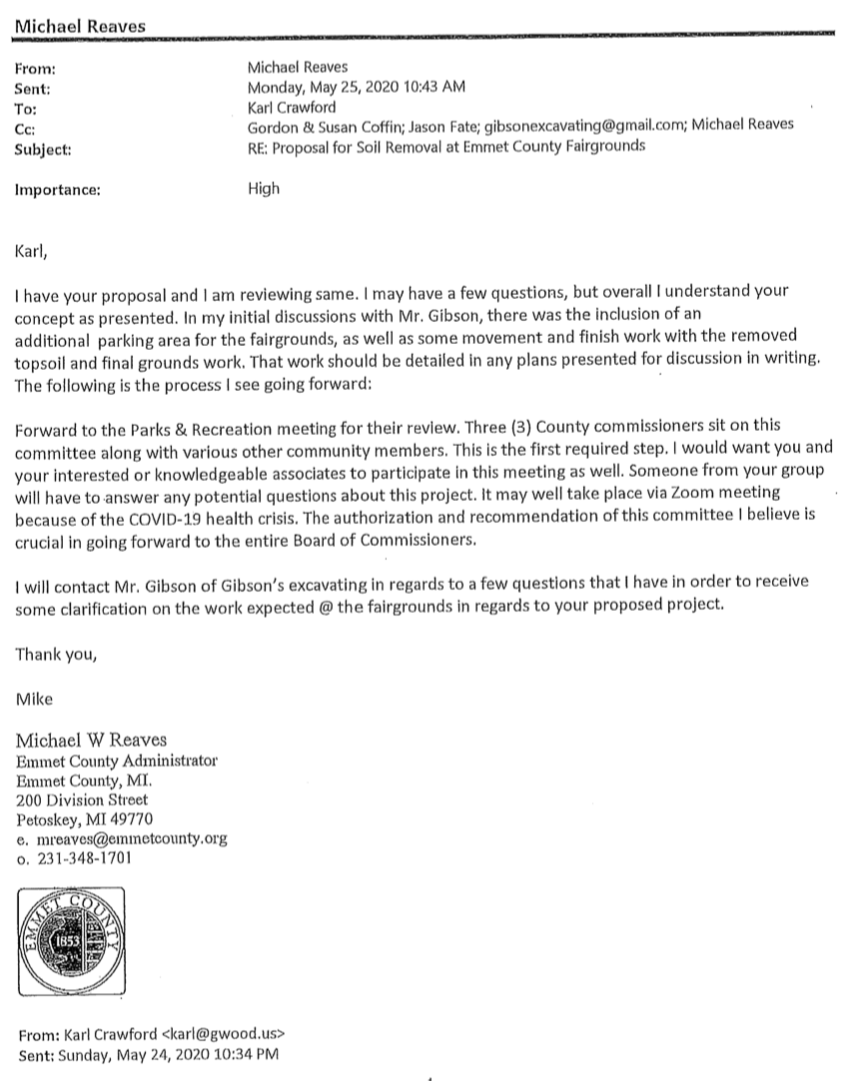
25 May 2020 Response to Cemetery Proposal from the Emmet County Administrator...
Below: The county administrator's summary for the 23 July 2020 ECBOC meeting explains how Greenwood Cemetery hopes to involve the county in cutting trees on county property, and re-landscaping an area near the fairground entrance that could be developed by the county in the future for a parking lot. The Cemetery, however, would gain a view with the trees gone, and the soil removed from the county property to be used as fill in the cemetery riverine ravine. No mention has been made by neither... the cemetery, nor the county, regarding the recent wheelway collaspe due to unstable ground associated with this known riverine area and this particular project. The cemetery does acknowledge they "continue to work with the City of Petoskey in regards to any erosion along Eppler Road.
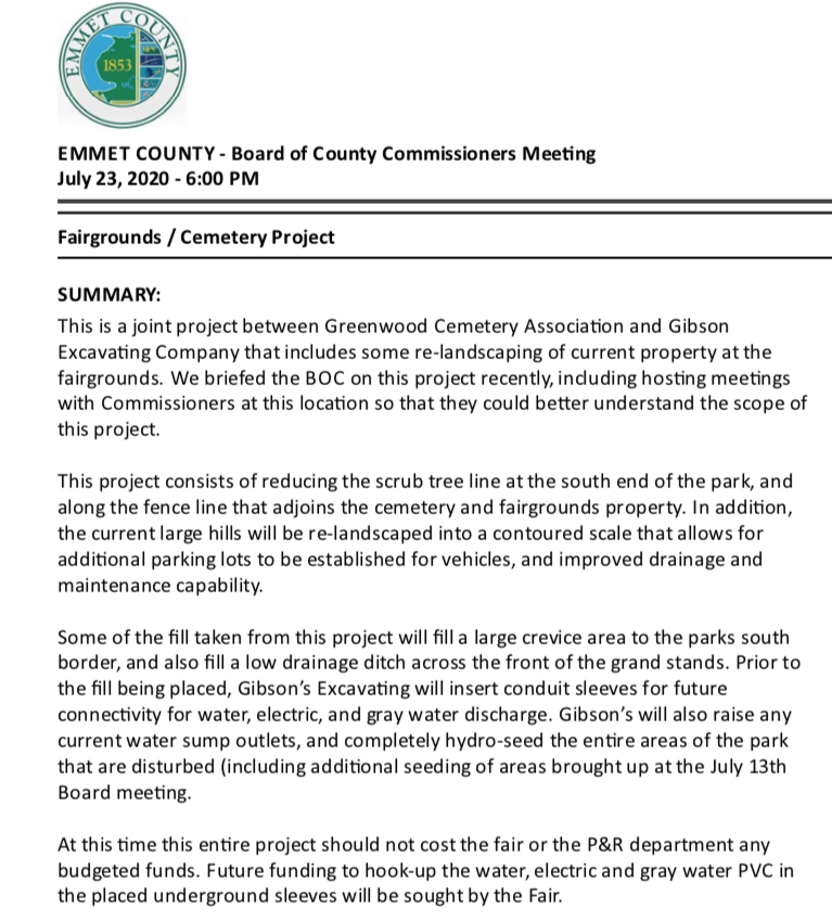
23 July 2020 ~ Emmet County Board of Commissioners Meeting Summary
Below: Letter of Notice from Gibson Excavating LLC explaining the services
to be performed for the county with the blessing of the cemetery.
to be performed for the county with the blessing of the cemetery.

The entire cemetery and fairground proposal may be accessed
by clicking HERE on the county's web page.
by clicking HERE on the county's web page.

23 July 2020 ~ Emmet County Board of Commissioners Minutes...
10 August 2020 ~ Emmet County Board of Commissioners Committee of the Whole meeting administrator Reave's report...
The county commissioners agreed to the cemetery's proposal
to cut the trees in the riverine and to place fill-dirt in the riverine.
~~~~~~~~~~~~~~~~
You can put lipstick on a pig, but it is still a pig!
A riverine can have its vegetation cut, or can be covered with "whatever" but it is still a riverine!
to cut the trees in the riverine and to place fill-dirt in the riverine.
~~~~~~~~~~~~~~~~
You can put lipstick on a pig, but it is still a pig!
A riverine can have its vegetation cut, or can be covered with "whatever" but it is still a riverine!
~~~~~~~~~~~~~~~~
The county/fairground "re-land sculpting project" will be completed Spring 2021.
Below Administrator Reaves' Report
The county/fairground "re-land sculpting project" will be completed Spring 2021.
Below Administrator Reaves' Report
22 October 2020 ~ Administrator Reaves' Report
Slideshow Below: Click PLAY in the upper left corner or click on the individual thumbnail photo at the top...
10 January 2021
The re-land sculpting project was in progress. The vegetation in the riverine of the cemetery had been removed.
The hill certainly, as assumed for the area, looks to be a sand dune.
10 January 2021
The re-land sculpting project was in progress. The vegetation in the riverine of the cemetery had been removed.
The hill certainly, as assumed for the area, looks to be a sand dune.

12 July 2021 ~ ECBOC meeting Administrator Mike Reave's report...
Photo Below AND the Photos in the Slideshow Below clearly show
the erosion that has transpired since the movement of land in the riverine location.
What else was to be expected?
Click PLAY on the upper left corner of the slideshow to view...
the erosion that has transpired since the movement of land in the riverine location.
What else was to be expected?
Click PLAY on the upper left corner of the slideshow to view...
24 July 2021 ~ Same date as the multiple photos in the slideshow below...
THREE MONTHS AFTER PHOTOS ABOVE WERE TAKEN:
5 October 2021 ~ Parks & Recreation Board Meeting Minutes
Fairgrounds Project w/Greenwood Cemetery:
"Reaves reported that the work on the project at the Fairgrounds is almost completed.
There has been some hold up on the electrical for the hookup in the boxes and
they also need to do some cleanup from water runoff and reseeding."
Three Photos Below: 8 June 2022
Inside Greenwood Cemetery grounds on the road that exits on to Eppler (Wash Out) Road
showing the sand fill over the riverine for added cemetery plots "with a view".
Inside Greenwood Cemetery grounds on the road that exits on to Eppler (Wash Out) Road
showing the sand fill over the riverine for added cemetery plots "with a view".
8 June 2022 ~ View from inside Greenwood Cemetery on the road that exits on to Eppler (Wash Out) Road
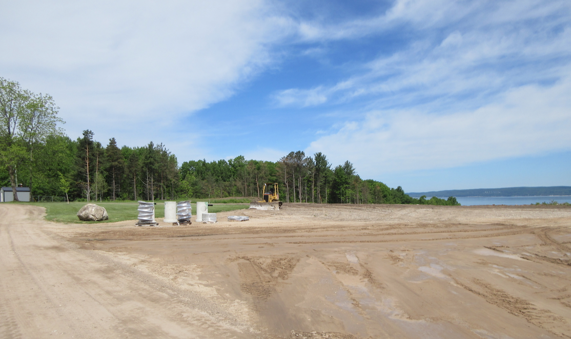
8 June 2022 ~ View from inside Greenwood Cemetery on the road that exits on to Eppler (Wash Out) Road
|
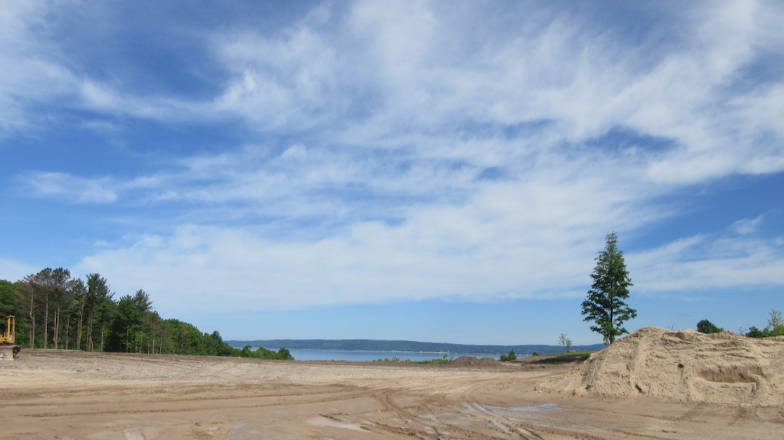
8 June 2022 ~ View from inside Greenwood Cemetery on the road that exits on to Eppler (Wash Out) Road
|
Three Photos Below: 4 April 2023
View of Greenwood Cemetery grounds from Eppler (Wash Out) Road
showing the riverine where trees were removed...
but, now the Greenwood Cemetery Board has approved about $30,000 to replace some of those trees.
View of Greenwood Cemetery grounds from Eppler (Wash Out) Road
showing the riverine where trees were removed...
but, now the Greenwood Cemetery Board has approved about $30,000 to replace some of those trees.
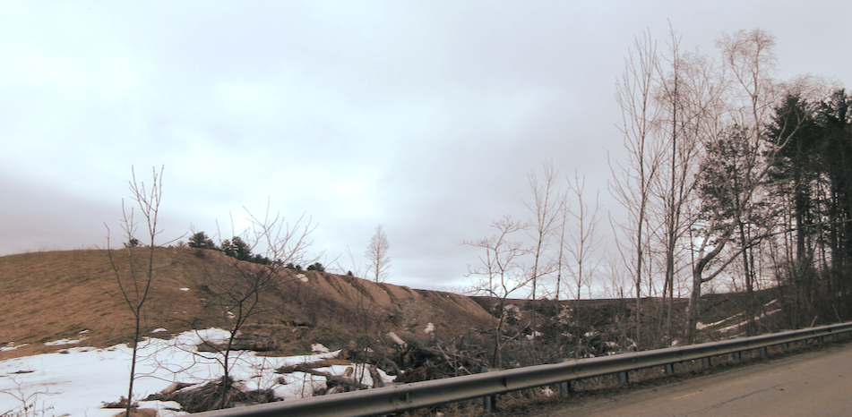
4 April 2023
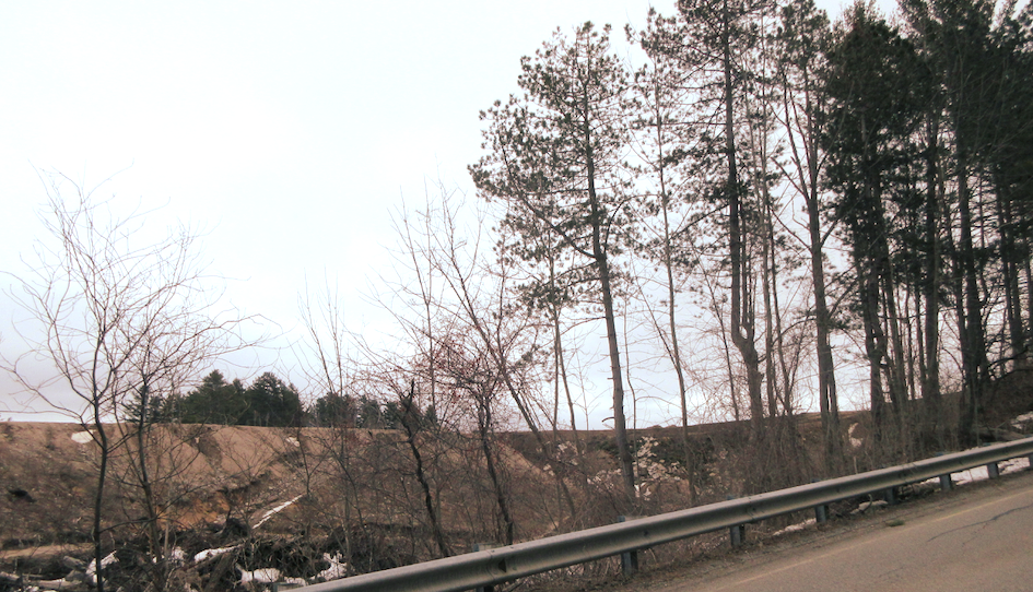
4 April 2023
|
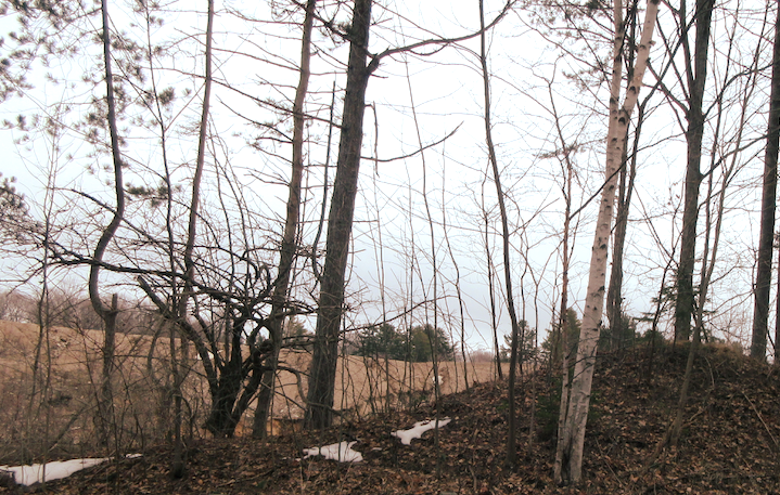
4 April 2023
|
A 4 May 2023 Greenwood Cemetery communications stated: "We are thrilled to present our plans for the development of five acres located at the southeast corner of Greenwood and Sheridan. This new forest area of the cemetery, when it is complete, will have a butterfly garden, walking trails, a scattering garden, wildflowers, wild blueberry bushes, and, not to mention, trees, trees and more trees! Planting is already underway, and we cannot wait to watch it grow."
Maple River Property for Sale?
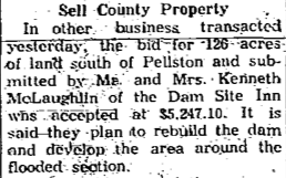
19 January 1963 ~ Petoskey News Review
Article Above: 126 acres of Cape Riverfront land for $5,247.10... the same land that Mr. and Mrs. McLaughlin in 1967 transformed into Lake Kathleen. Then,by 2018, the tribe facilitated totally removing this dam and drained Lake Kathleen. Neither, the dam nor the lake, any longer exists. Additional information about the Maple River, the dam, and Lake Kathleen may be accessed by clicking HERE.
MORE Maple River Property for Sale?

11 June 2019 continued below...
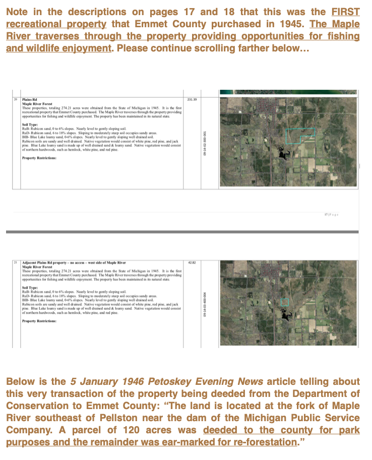
11 June 2019 continued below...
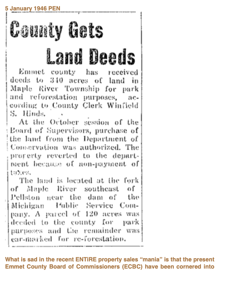
11 June 2019 continued below...
11 June 2019 continued from above...
Eventually, the ECBOC were advised that this sale was not a possibility because of the restrictions noted above. This was an exercise in futility since the county's administrator is to present a list of possible sales of county land properties in March of each year which had not been done. Had that list been prepared and presented as directed, this entire possible Maple River property sale would not have reached this point, and taken up time.
~ More... Previously County Owned Maple River Property ~
1970
1970
It is not clear IF this following Maple River property, proposed by the county and a member of the public to be traded, is the same piece of Maple River property contemplated being sold above in 2019. The amazing consideration is that public property is seemingly so easy to be sold, traded, deeded away, or in some way making the property no longer accessible by the public; because someone within the government determines that is in the best interest of the public????
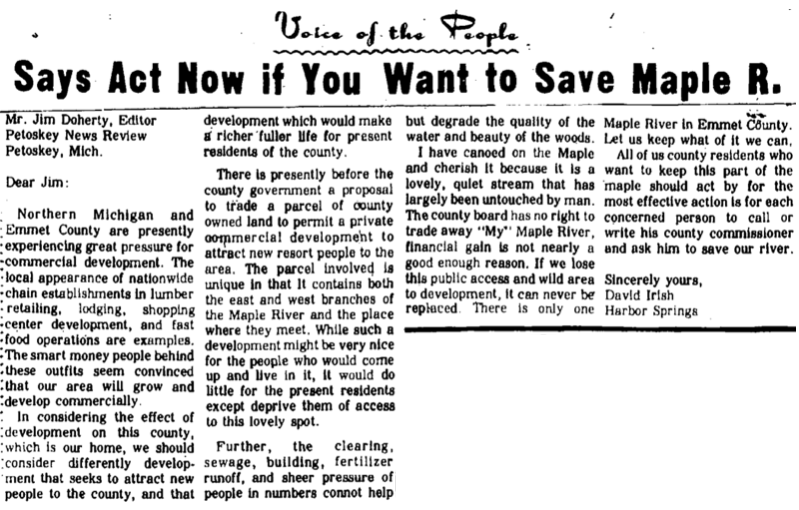
27 November 1970 ~ Petoskey News Review

27 November 1970 ~ Petoskey News Review
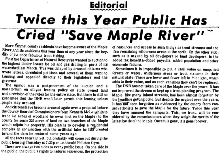
30 November 1970 ~ Petoskey News Review
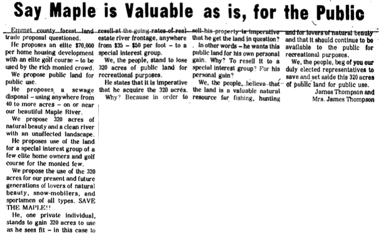
30 November 1970 ~ Petoskey News Review
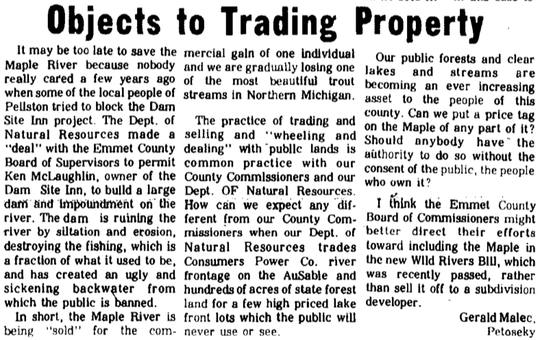
30 November 1970 ~ Petoskey News Review
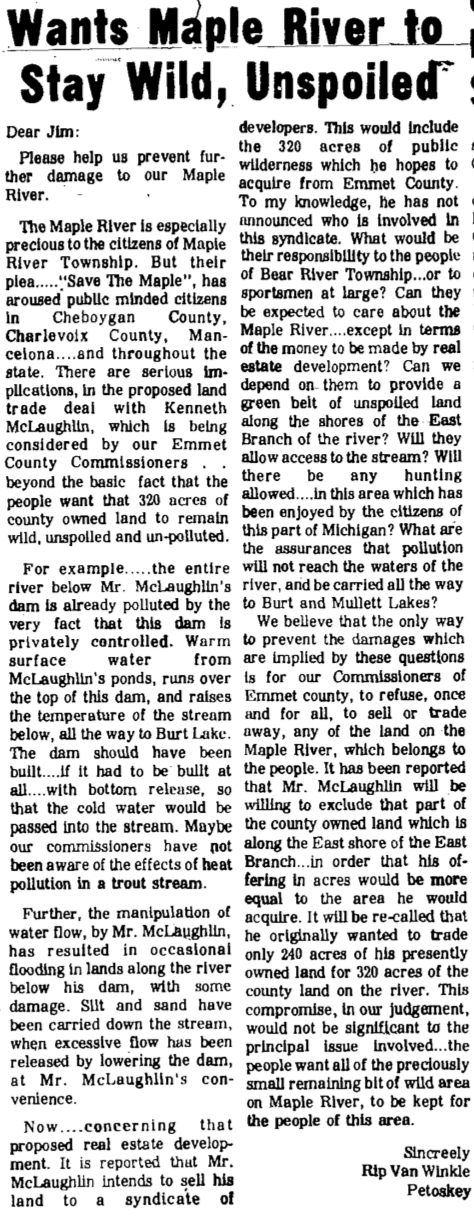
1 December 1970 ~ Petoskey News Review
|
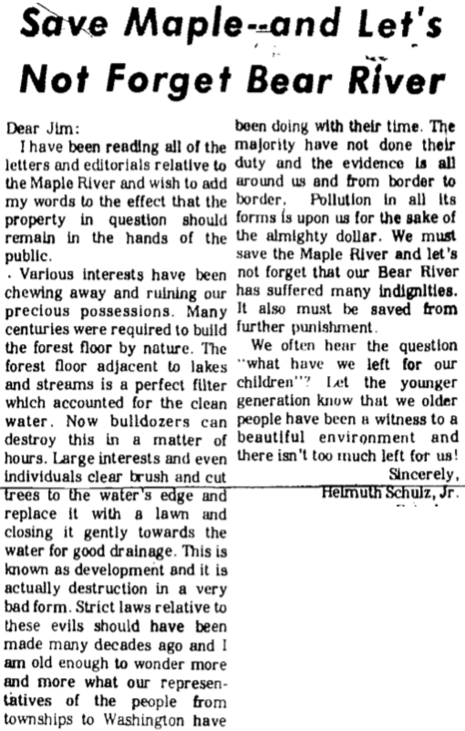
2 December 1970 ~ Petoskey News Review
|
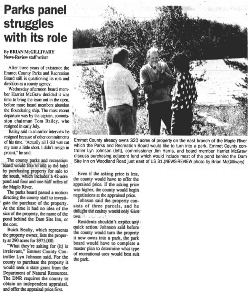
20 August 1992 ~ Petoskey News Review
~Emmet County Government Building~
Owned by Emmet County - Located corner of Division and Lake streets, Petoskey, Michigan
Owned by Emmet County - Located corner of Division and Lake streets, Petoskey, Michigan

30 September 1965 ~ Petoskey News Review
View the Slideshow Below by clicking on PLAY in the upper left corner
of the picture of the Emmet County building
which previously also housed the city offices.
Click PAUSE to view the photos longer.
The OLD county building was razed in 1965, with the clock and the bell in the tower being dismantled. Both the clock and the bell are hanging in the clock tower at the waterfront in 2019.
(The photos in the slideshow are from the
Greenwood Archive Collection from Petoskey Newspapers; some dated 1965)
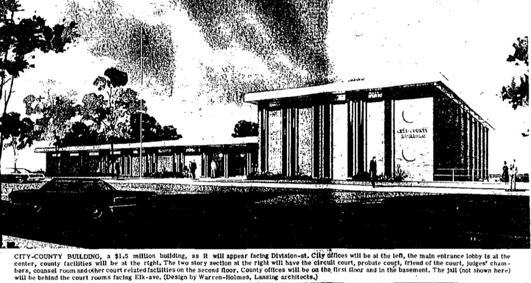
11 September 1965 " Petoskey News Review
Emmet County AND City of Petoskey LOGOS
1965 >
1965 >
|
3 July 1965 ~ Petoskey News Review
|
14 July 1965 ~ Petoskey News Review
|
13 August 1965 ~ Petoskey News Review
|
10 September 1965 ~ Petoskey News Review
Text under photo above: "Symbols used would be the plowshare, passenger pigeons, pine tree, lumber area axe and cant hook, a skier, fisherman and deer." It seems the plowshare, a fisherman and deer were NOT used as symbols on the seal, although the other symbols were incorporated. Additional information about the County Seal, Design, or Logo may be accessed on this same web site on the "Publicly Speaking" web page by clicking HERE.
Photos Below: The City Offices were Housed in the County Building when the building was first constructed on the corner of Lake and Division streets.
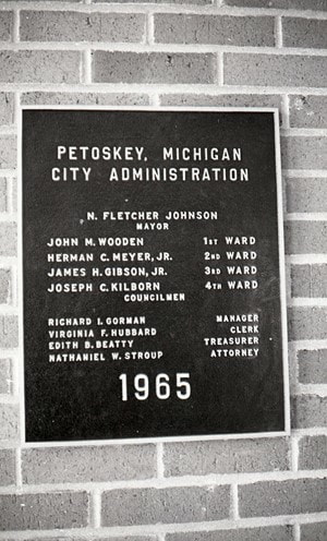
|
|

14 April 1966 ~ Petoskey News Review
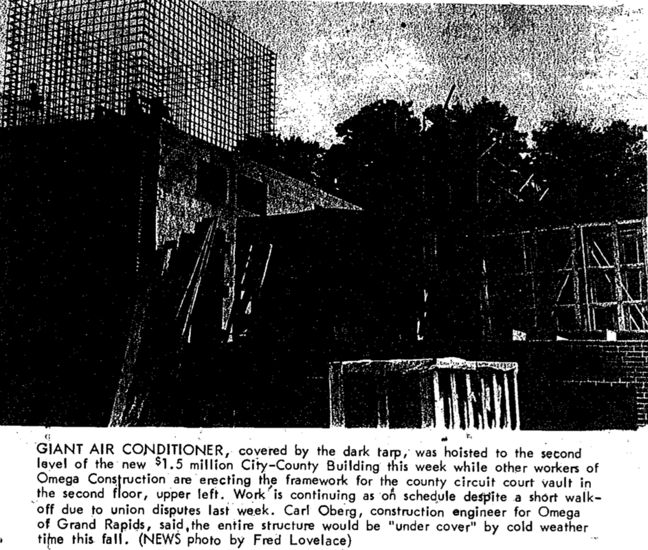
20 July 1966 ~ Petoskey News Review
~ Eppler Road (Washout) Property ~
and
Wetland Riverines
and
SALE OF PARCELS of EMS PROPERTY
(Much of this information below also is relevant to the Wheelway Erosion above.)
and
Wetland Riverines
and
SALE OF PARCELS of EMS PROPERTY
(Much of this information below also is relevant to the Wheelway Erosion above.)
Map Below: The red enclosed property is the Eppler Road, Petoskey, Michigan, property that Emmet County owns in Resort Township. The EMS building is that which is shown toward the left end. This 10 acre parcel was purchased for over $200,000.00 for the purpose of building the EMS station. In 2019 the building is having significant water issues. Notice that on this map from the wetlands web site, TWO riverine areas run right through the property, so water issues should not be a surprise. Beginning August 2019 Emmet County and the Emmet County Road Commission both publicly expressed desire to acquire (swap county owned land with Emmet County for services from the Emmet County Road Commission) a portion of the county's Eppler Road property to place a salt shed. Will recognized water issues create runoff involving salt storage leachate? Will the public be made aware of the value of the particular parcel, and also the value of the swapped service, and what service is included? Will the public even be made aware of this transaction taking place BEFORE it takes place? So far, on 4 October 2019, the only people who are aware attended and/or read the minutes from a recent Parks & Recreation Board meeting and recent Emmet County Road Commission meetings.
A 2 September 2019 Petoskey News Review article titled
"Emmet County EMS Station to Undergo Repairs"
describes the extent of water damage, and the expensive bid options for repair.
"Emmet County EMS Station to Undergo Repairs"
describes the extent of water damage, and the expensive bid options for repair.
"The repairs will go toward addressing flooding and improper drainage issues in and around the station. Those issues revealed themselves this spring, after the built-up snow thawed out around the building....
The winning bid, which was awarded late last month, will go to Gibson Excavating of Boyne Falls for $24,000. The other two bids both came in higher, at $36,350 and $51,000.
To fix the problem, Gibson Excavating will install a 320-foot-by-24-foot culvert for a drain ditch on the south and west side of the property.
Then, crews will install two 4-foot-by-6-foot manholes with sump pumps, and connect those to the drains. After that, the company will backfill over the drain and fix the spillway at the points where water enters the property."
At the 13 April 2020 on-line ECBOC meeting the idea of selling/trading the property behind the EMS building was brought before the board by Administrator Mike Reaves. The meeting packet included various associated attachments: Eppler Road emails, tax description, real estate summary sheet, and GIS map. The commissioners decided since the road commission was not in a particular hurry to make this transaction with all of the Corona-19 Virus activity, that this property did not need to be discussed further at this time.
By November 2019 the Emmet County Administrator informed the Emmet County Board of Commissioners that not only was the road commission interested in a piece of the Eppler Road property, but also Lori Draves-Reynaert and Martin Reynaert who would use the property for the "intended purpose of placing an assisted-living facility" had expressed interest through a local realtor.
By November 2019 the Emmet County Administrator informed the Emmet County Board of Commissioners that not only was the road commission interested in a piece of the Eppler Road property, but also Lori Draves-Reynaert and Martin Reynaert who would use the property for the "intended purpose of placing an assisted-living facility" had expressed interest through a local realtor.
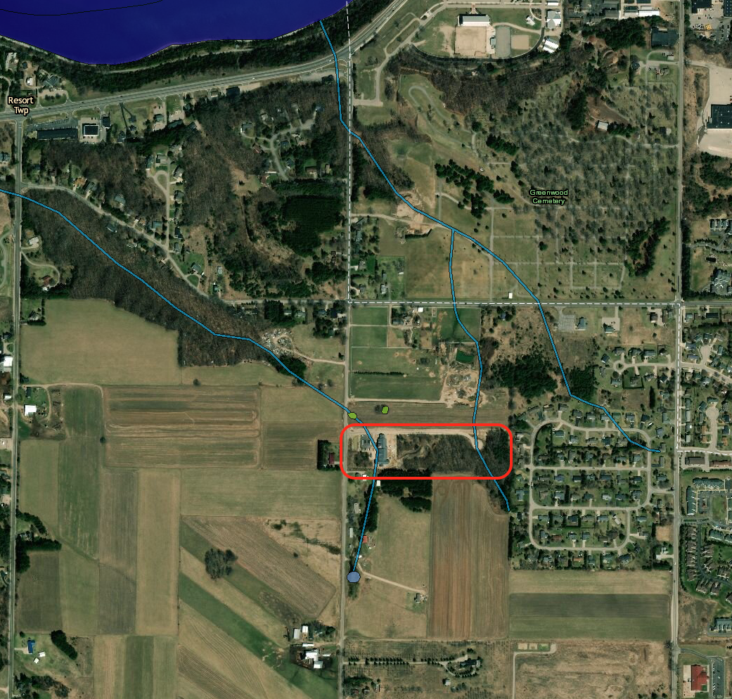
25 September 2019
The great Charlevoix Road Washout of March 1913 is better understood when viewing the wetlands map above with the two riverine areas leading right to the bay... crossing what is Eppler Road in 2019.
In 1913, however, people were "puzzled" over "the fact that there is no river or stream in the neighborhood of the washout" as described in the article below right.
In 1913, however, people were "puzzled" over "the fact that there is no river or stream in the neighborhood of the washout" as described in the article below right.
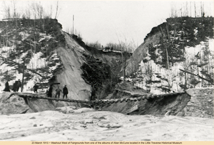
Photo Above : "The cut is fully a thousand feet long, and about the width of a city street.... seventy feet deep." as reported in the 24 March 1913 Petoskey Evening News. |
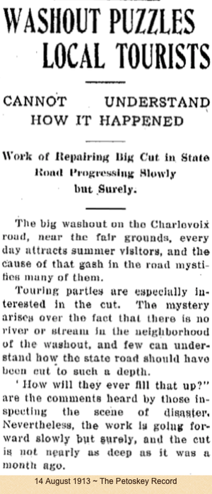
|
Resort Township Remembers on page 156 stated about "The Washout": "For many years the road was known as Washout Road. In the 1930's when large trucks from southern states came to transport potatoes from the Ray Eppler farm, drivers were hesitant to drive their trucks on a road named Washout Road. Upon learning of the problem Mrs. (Louise) Eppler hurriedly called on all the residents of the road seeking their approval to change the name to Eppler Road. This ended the truckers' uneasy fears and the name Eppler Road has remained."
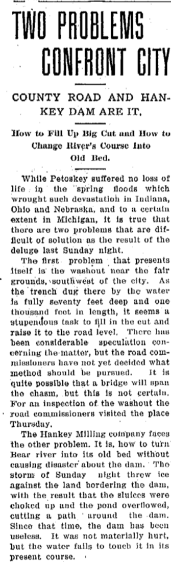
27 March 1913 ~ Petoskey Evening News continued next column...
|
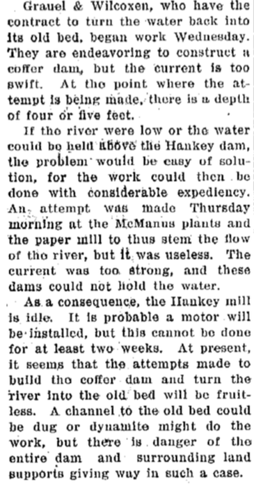
27 March 1913 ~ Petoskey Evening News continued from left column...
|
Photo Below: Reverend George Weaver was the FIRST Sunday School Missionary in the area. Additional information about his many travels connected to multiple Sunday Schools and visit, as well as information about his 1911 Hupmobile may be accessed by visiting on this site: "Churches" and "Vehicles and Bicycles." It is explained below that "... when the Weavers were returning from the Crusher School; The team became frightened. After wrecking the sleigh, they freed themselves, dashed through the temporary barriers set up at the Charlevoix washout, just the other side of the Fair grounds, and one was killed. This was a very harrowing experience for both Mr. and Mrs. Weaver."
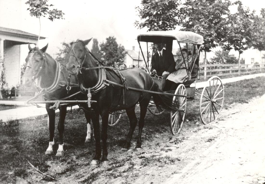
Greenwood Photo Archive Collection from Petoskey newspapers accompanying the following description...
|
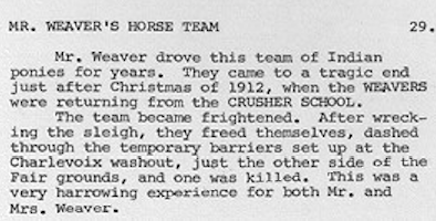
Greenwood Photo Archive Collection from Petoskey newspapers accompanying the photo above...
|
|
13 November 1911 ~ Petoskey Evening News
|
The description above right is accurate, but the year is incorrect. The following identical accident was described in the 17 November 1911 newspaper as shown below. Obviously, a washout had occurred as reported in the 1911 article left that prior to the massive photographed washout in the same area in 1913.
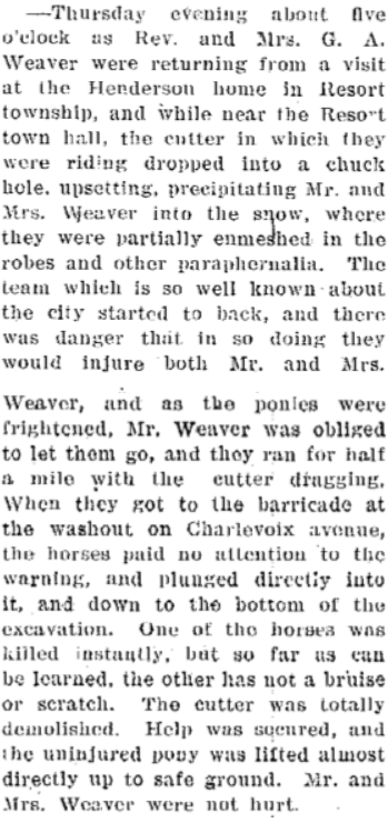
17 November 1911 ~ Petoskey Evening News
|
If anyone is to doubt the power of wetland riverine areas,
consider the SAME "Washout/Eppler Road" area in 1957 as described in the photo/text below.
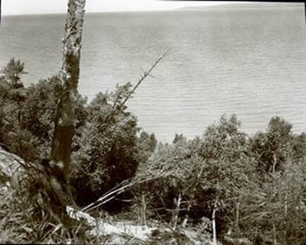
Greenwood Photo Archive Collection from Petoskey newspapers (July 1957)
|
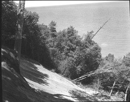
Greenwood Photo Archive Collection from Petoskey newspapers (July 1957)
|
2 July 1957 ~ Petoskey News Review
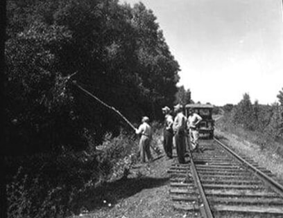
Greenwood Photo Archive Collection from Petoskey newspapers (July 1957)
The State of Michigan is the only state in the nation which has TWO initial points for Meridian Baselines.
Click HERE...
to access a video which explains how it came to be that Michigan has two points of Meridian Baselines.
Click HERE...
to access a video which explains how it came to be that Michigan has two points of Meridian Baselines.
