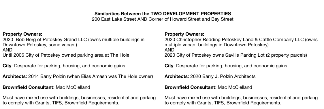
Northern Mich~Mash Preserve
~"The Hole" ~ Second Coming?~
(Corner of Howard Street and Bay Street in Petoskey)
The design and compilation of the text and photos on this site are copyrighted 2017.
Most posted items will enlarge by "clicking" on them.
"Clicking" on some color highlighted words may access additional information.
Most posted items will enlarge by "clicking" on them.
"Clicking" on some color highlighted words may access additional information.
Please do not copy the photos on this site, many of which have been submitted by private individuals...
just come back and visit the site often to view the photos.
just come back and visit the site often to view the photos.
Two Drawings Below: Within two and a half months in 2020, Plans for the 20 APARTMENTS (left),
plus commercial spaces... "morphed" into Plans for a 50 room HOTEL (right)
to occupy the corner of Howard Street and Bay Street.
plus commercial spaces... "morphed" into Plans for a 50 room HOTEL (right)
to occupy the corner of Howard Street and Bay Street.
RESIDENTIAL (with street businesses) >>>>>> HOTEL (only)
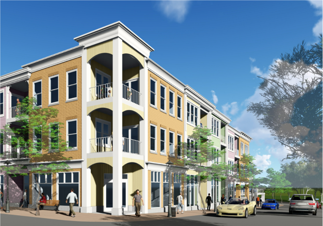
11 February 2020 ~ Bay Street Development architectural drawing of APARTMENTS... of same perspective as the Header Photo above...
|

28 April 2020 ~ Bay Street Development architectural drawing of HOTEL...of same perspective as the Header Photo above...
|
Access information about Hole #1, the PRE-SEQUEL, by clicking HERE.
In the Beginning of the Second Coming... The Hole?
2020
2020

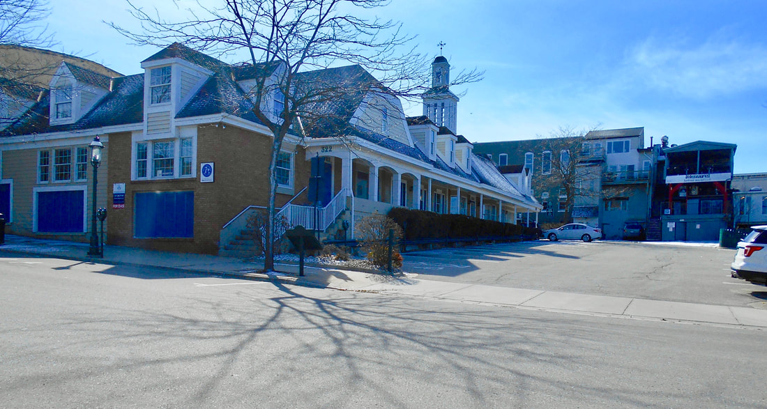
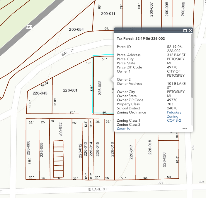
Sign/Map pointing out the area of 322 Bay Street
322 Bay Street, Petoskey, Michigan, owned by Petoskey Land & Cattle Co LLC
as of 21 March 2020 according to the Emmet County Property Search web site.
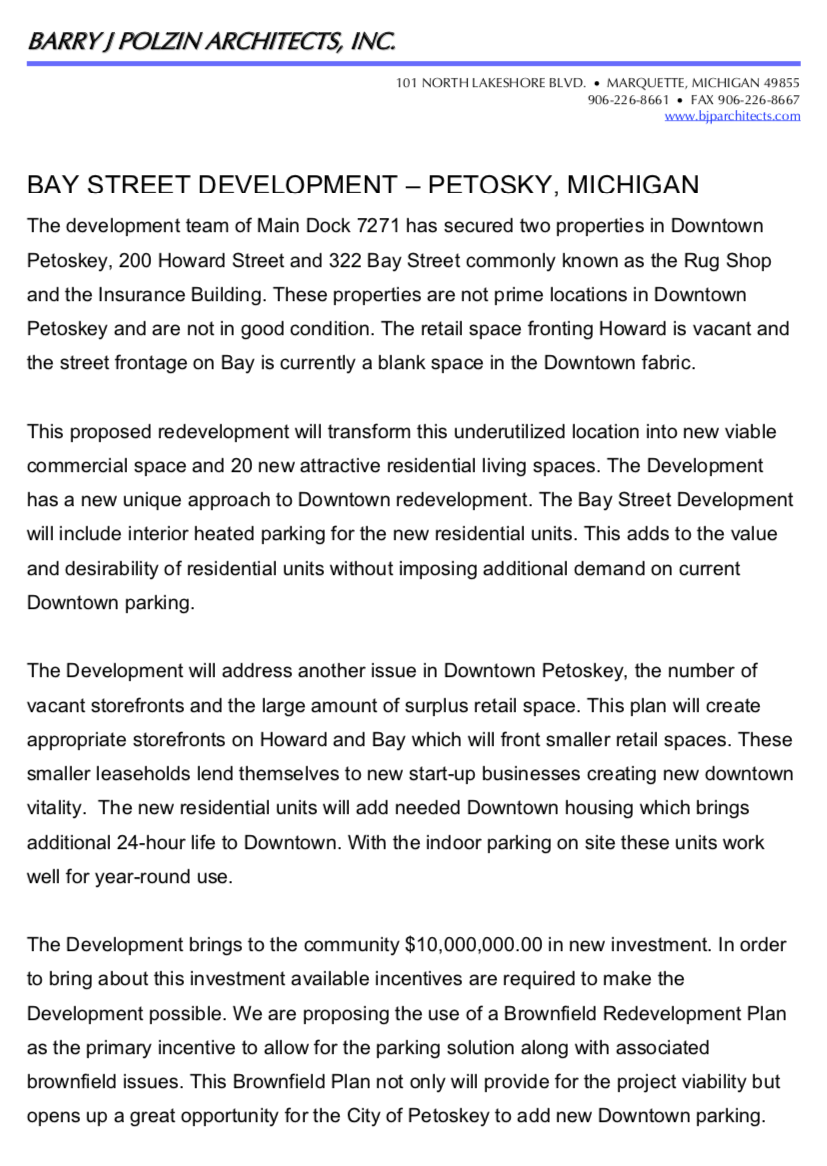
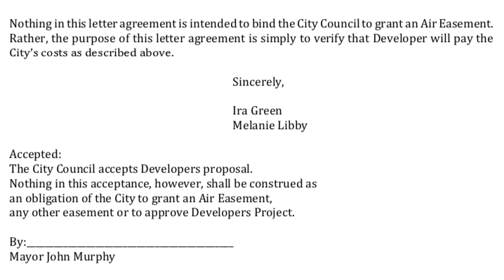
A letter, however, from Barry J. Polzin Architects, Inc. included in the packet for a 17 February 2020 Petoskey City Council meeting stated,
"The development team of Main Dock 7271 has secured two properties in Downtown Petoskey,
200 Howard Street and 322 Bay Street commonly known as the Rug Shop and the Insurance Building."
While public records, as of 21 March 2020, do not show that any transaction has happened,
the City Council information stated the properties are "currently under contract" by Main Dock 7271.
Main Dock 7271 is a real estate company formed by Ira Green and Melanie Libby.
In the 4 May 2020 Agenda Memo for the city council meeting Ira Green and Melanie Libby
are identified as "developers of the project," referring to it as the "Bay Street Development" property.
(322 Bay Street building appears to be mostly vacant 21 March 2020)
21 March 2020

21 March 2020 ~ Emmet County GIS Property Map (322 Bay Street shown in photo above)
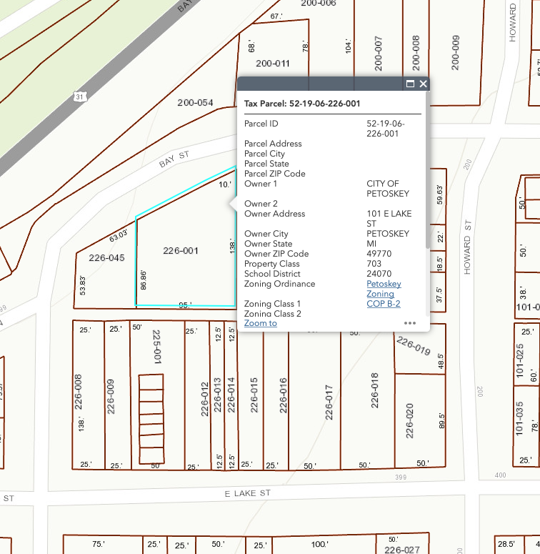
200 Howard Street, Petoskey, Michigan, owned by Petoskey Land & Cattle Co LLC
Same explanation of ownership is shown above.
(building appears to be vacant 21 March 2020)
Same explanation of ownership is shown above.
(building appears to be vacant 21 March 2020)

21 March 2020
Photo Below:
This 1896 corner of Howard and Bay Street is the same corner being considered for development in 2020.
This 1896 corner of Howard and Bay Street is the same corner being considered for development in 2020.
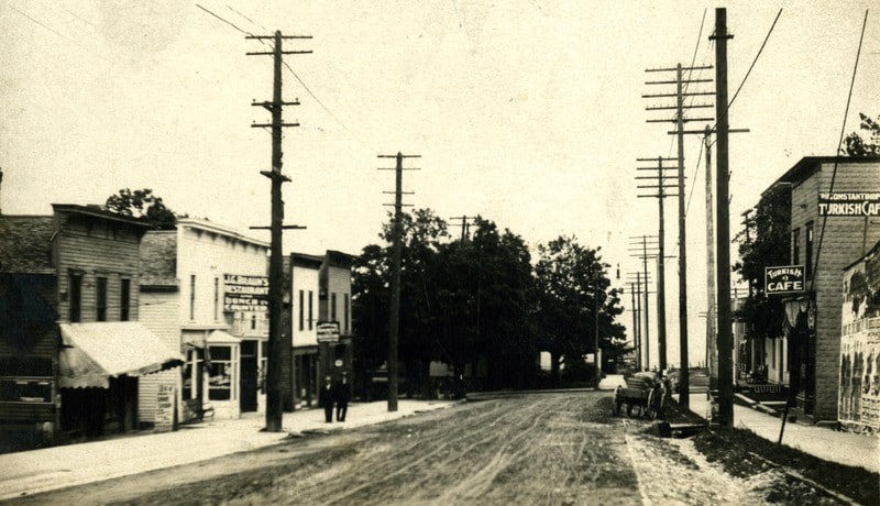
Little Traverse Historical Society Photo Collection (1896)

21 March 2020 ~ Emmet County GIS Property Map (200 Howard Street shown in photo above)
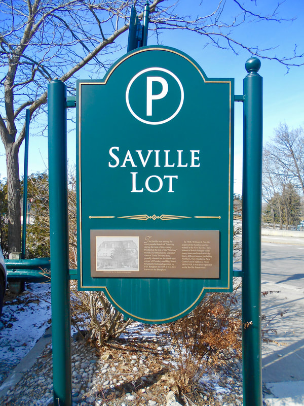
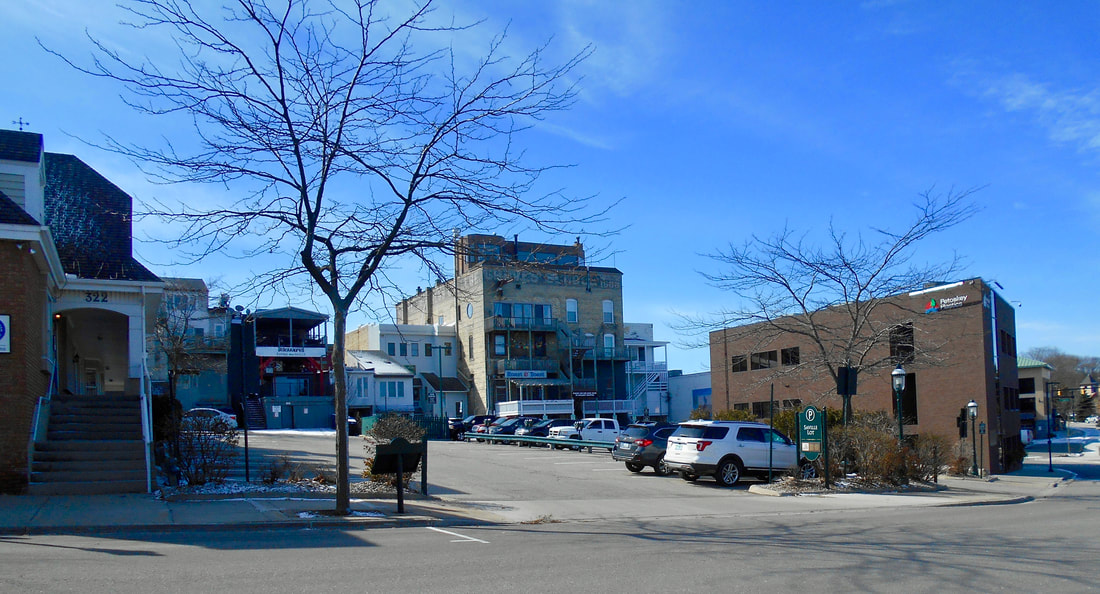
The City of Petoskey owns the Saville Lot on Bay Street
(comprised of two separate property parcels, both affording an unobstructed view of the bay)
(comprised of two separate property parcels, both affording an unobstructed view of the bay)
21 March 2020
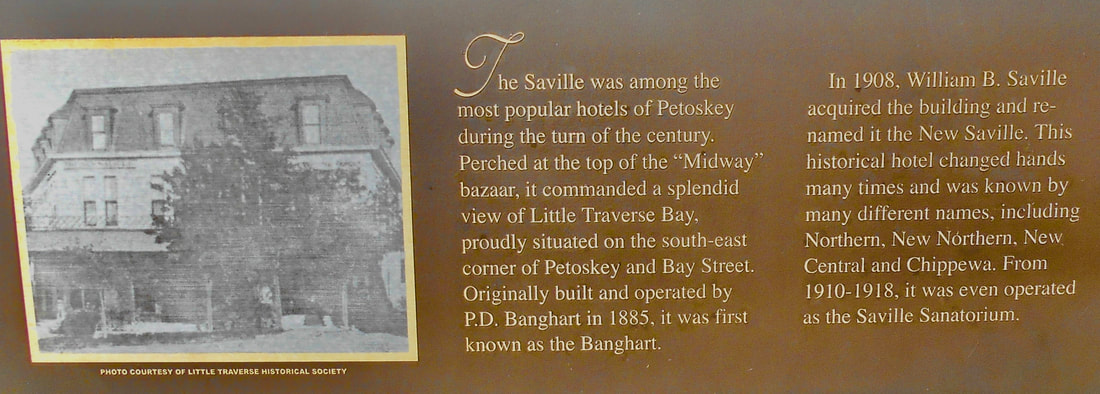
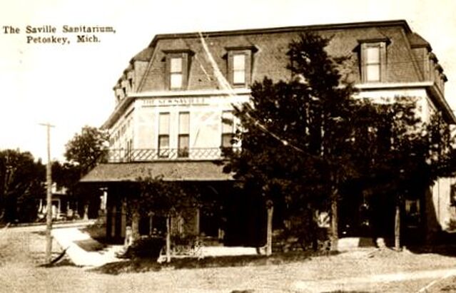
The information (shown below) posted on the Saville Lot sign tells the history of the location which is right next to the the property where the "Saville Sanitorium," as well as a hotel which went by different names as it changed hands. This location is now that of Petoskey Plastics, One Petoskey Street, Petoskey, Michigan. Click HERE for additional information on this same web site about Petoskey's hotels. Homes also had been located on the property, but razed to make way for the parking lot.
21 March 2020
Little Traverse Historical Society Photo Collection
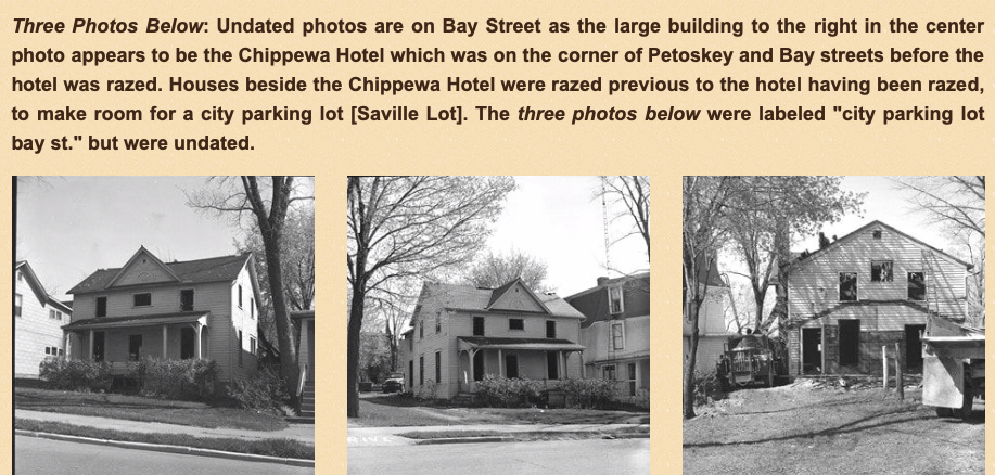
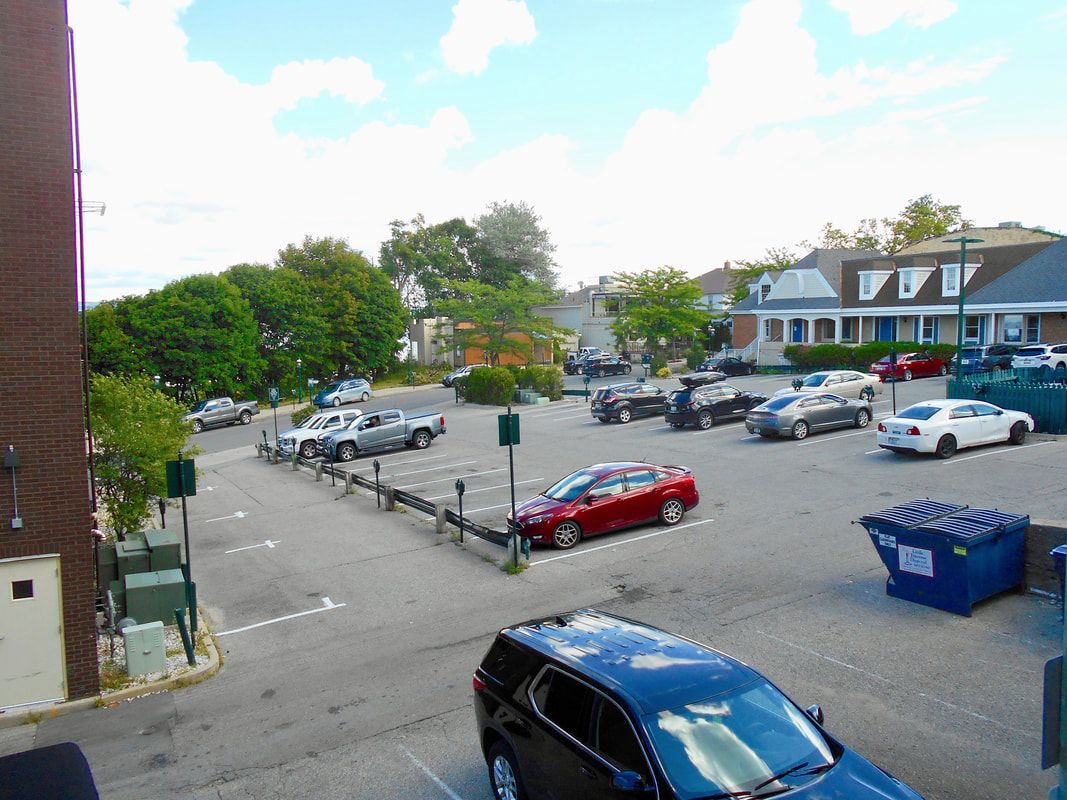
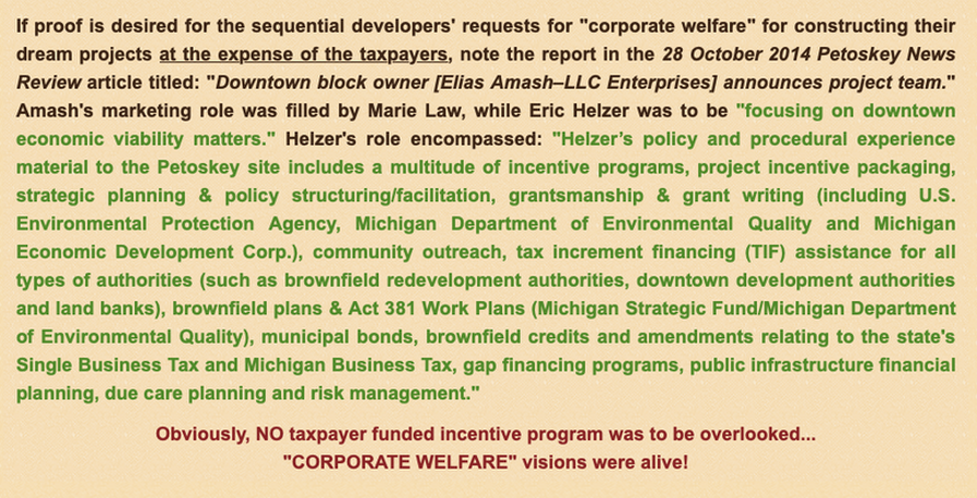
Photo Below: One of the city's two parcels (shown in the two property maps below) of the Saville Lot can easily be viewed at 312 Bay Street (to the right of 322 Bay Street owned by Petoskey Land & Cattle Co LLC), all to be included in the proposed Howard and Bay streets development. The lot in the below photo, however, does extend onto another city parcel still referred to as Saville Lot, extending over to the right (west) side, as in the photo below, of Petoskey Plastics located at 1 Petoskey Street, Petoskey, Michigan.
21 March 2020
Photo Below showing present parking: The Saville Lot includes the parking spaces as shown in this photo left to right (west to east, looking north toward Bay Street with the garbage bin sitting on the south side of Shoppers Alley):
04 Spaces right next to Petoskey Plastics Building
10 Spaces metered in next row with red car in photo foreground
11 Spaces metered in next row to right with four parked cars.
09 Spaces metered in row with utilities fenced off
14 Spaces metered in row closest to the building located at 322 Bay Street
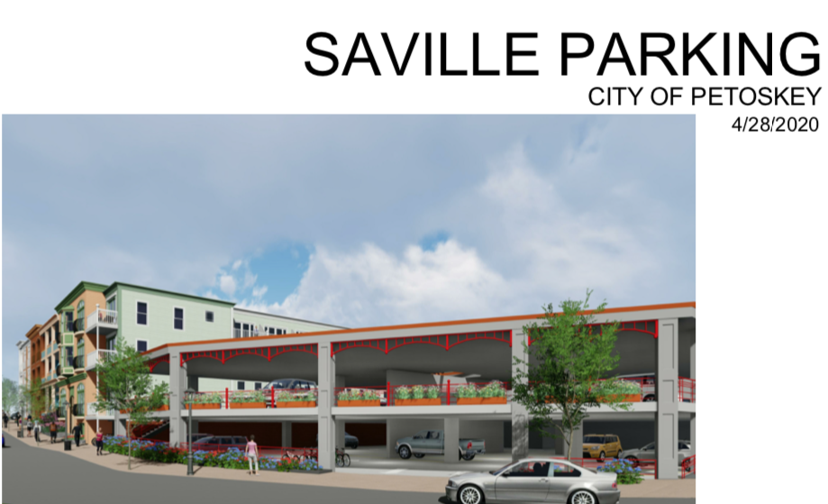
TOTAL 48 spaces.
04 Spaces right next to Petoskey Plastics Building
10 Spaces metered in next row with red car in photo foreground
11 Spaces metered in next row to right with four parked cars.
09 Spaces metered in row with utilities fenced off
14 Spaces metered in row closest to the building located at 322 Bay Street
TOTAL 48 spaces.
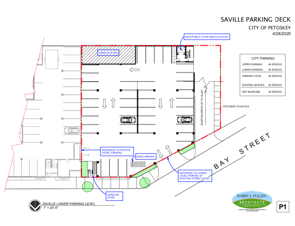
IF the city were to build the proposed Main Dock developer's parking plan, a total of 84 spaces for a two level parking structure would possibly be created, meaning only a net increase of 36 spaces would be gained for the city spending several millions of dollars... and the open air structure proposed by Main Dock would probably not support any type of third floor expansion for housing and/or business spaces for the city. A parking deck that would support a third floor, would undoubtedly cost more millions than Main Dock is telling the city officials they would need to spend in the future.
22 July 2020
21 March 2020 ~ Emmet County GIS Property Map (Bay Street Saville Lot shown in photos above)
|
21 March 2020 ~ Emmet County GIS Property Map (Bay Street Saville Lot shown in photos above)
|
Slide Show Below: Click on Play in the Upper Left Corner OR Pause to temporarily stop;
OR Click on individual pictures above the slide show.
OR Click on individual pictures above the slide show.
Letter from Polzin Architects, Inc included in public records for 17 February 2020 Petoskey City Council meeting coninued at right...
|
Letter from Polzin Architects, Inc included in public records for 17 February 2020 Petoskey City Council meeting coninued from left...
|
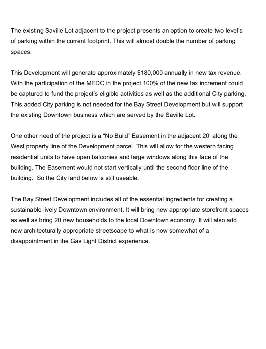
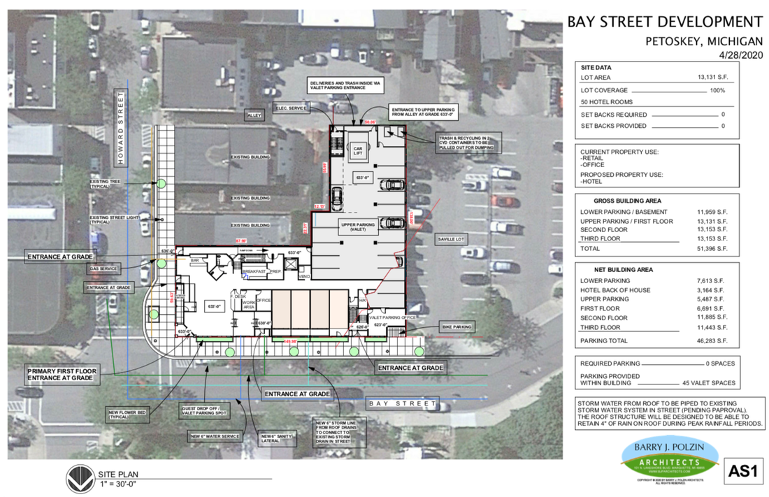
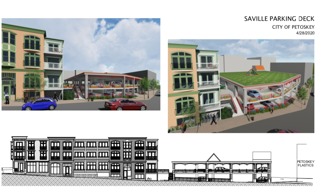
Barry J. Polzin Architects, representing Main Dock 7271, approached the city with plans to create retail and residential spaces, while including the city's Saville Lot property. The 10 March 2020 Petoskey News Review reported, "But the lot is also eligible as a brownfield site–properties identified by the state as contaminated, blighted or functionally obsolete. That would mean that the developers could use tax increment financing to help fund their development. Under such a plan, all additional tax revenue fostered by the new development would be funneled back into the district for a specific period of time, in this case 10 to 12 years. The developers estimate that the new properties would generate $180,000 annually in additional taxes. Part of that would go toward necessary aspects of the project itself, but part of it could also be used to build a new parking structure at the Saville Lot." The same news article also included the draft by Polzin of the preliminary plan, including a "performance plaza" on the city's property of Saville Lot, as shown below.
10 March 2020 ~ Petoskey News Review
The PLANS for Howard and Bay streets development, replacing mostly vacant spaces, as presented... are attractive, commendable, and not out of scale proportion-wise with surrounding structures; being mindful of ordinance heights limitations, first level commercial spaces, residential spaces, and the possibility of including a city parking structure (albeit on city property).
In the beginning PLANS, this development appears appealing. The city does have ordinances, and a master plan, which have been crafted to protect multiple assets; as with height restrictions and requiring businesses on ground levels, for the public's general benefit regarding developments. Those ordinances should be upheld, and not negotiated away, in the event that the city gets sucked into another Hole. These properties on Howard and Bay streets are prime pieces of property, owned privately now, and should be funded privately, not promoted and given away using public funds through Brownfields, TIFS, or tax abatements. Taxpayer subsidized, "Corporate Welfare" should not play a part of future development of the proposed development properties.
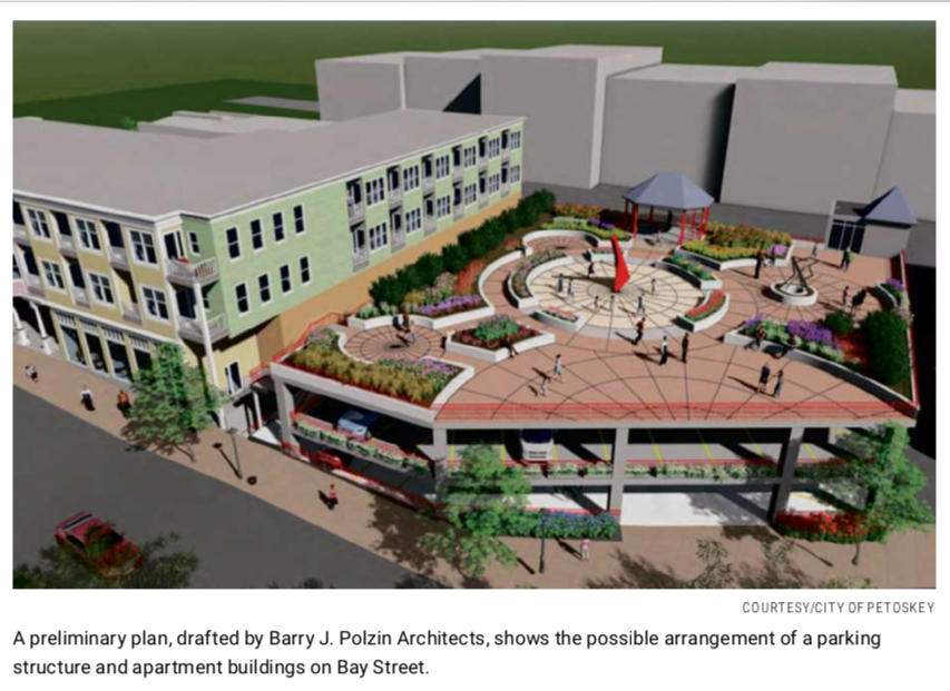
Draft drawing from Polzin Architects, Inc included in public records for 17 February 2020 Petoskey City Council meeting...
Drawing Above: The plan of a very similar, but simplified, view, both by Polzin Architect, must be showing a "dressed up" version in the top 10 March 2020 newspaper preliminary view, a little farther above. In the above bottom view no roof/park-like area is shown, but yet the brown/tan area on the side of the building is shown to be at the same height in both plans; one shows the floor of the second level, and the other plan shows the roof level of the second floor, but yet the same level... this does not compute! The perspective is different in the two drawings. With that glorified roof layer added, the parking structure will be higher than shown in the just above photo. The lower level of parking must be somewhat underground because it was written, as in the packet, for the city council, "The Saville Lot could be decked to approximately double the number of public parking spaces even with the 20 foot easement. One level would be accessed from Bay Street and the second would be accessed from Shopper's Lane. The design would maximize parking on the small foot print by not requiring internal ramps." How legal/safe is it to have only one way, in AND out, on each level for parking... especially since the Bay Street level also provides the only access for the additional heated parking for the 20 residential units under the building structure; so more parking under the residences. All of that, with one way in AND one way out existing on that lower parking level. Who is liable for that catastrophe waiting to happen? Does the terrain from Shoppers Lane (alley) to Bay Street require excavation on the Bay Street side, and thus the building (not the parking structure) becomes four stories, including the residential parking, rather than the stated 3 stories, or 40 feet? Without the development's access to its own underground parking property, THROUGH the city's property, that lower level parking element of the development could not exist. [LATER: The hotel architect proposed and drew plans for a jockeying valet to park cars via a car lift off the alley behind the hotel.]
Projected costs, whether financial, or otherwise, to the public would include: 1) the city forfeits 20 feet along the West property line of the Development parcel, through a "No Build" Easement [LATER: this morphed to an AIR easement to a VIEW easement and a LIGHT easement], in perpetuity. The city would never have the right to build a higher parking structure even if they wished. 2) forfeiture of taxes to the schools, roads, through the use of Brownfields and/or Brownfield TIFs. 3) zero lot line limits. 4) The plan for access to the two parking structure levels appears to LIMIT ease for fire safety (trucks) in narrow Shoppers Lane, to safeguard the buildings along the alley lane which actually face Lake Street. Radius turns for fire trucks would be extremely tight... creating a "fire box" with very real safety concerns. 5) Both long and short term maintenance costs for the parking structure must be addressed whether public, or private.
|
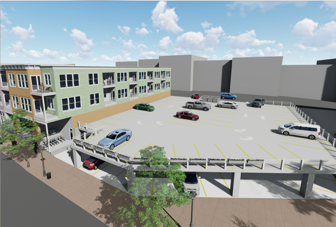
Draft Drawing Below: ONLY Bay Street Entrance to Lower Level City Parking AND to Lower Level Residence Parking 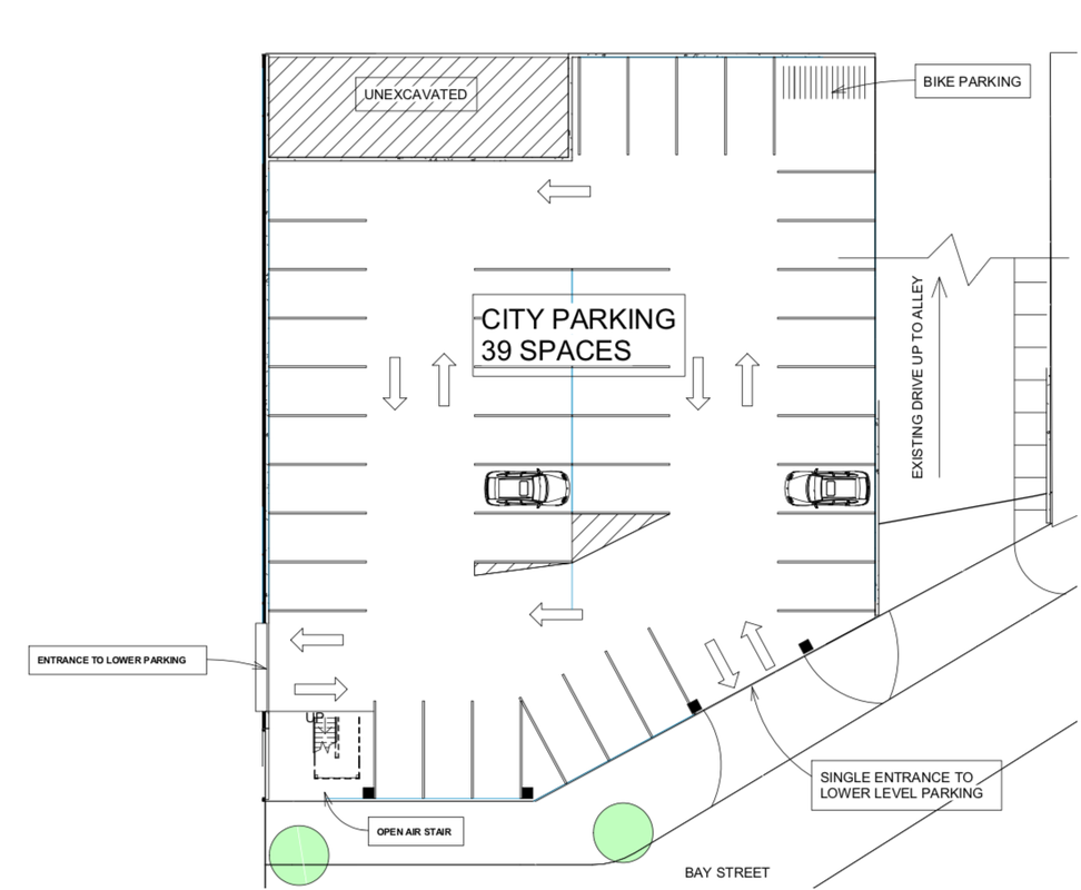
Draft drawing from Polzin Architects, Inc included in public records for 17 February 2020 Petoskey City Council meeting...
|
Draft Drawing Below: ONLY Alley Entrance to Upper Level City Parking. 
Draft drawing from Polzin Architects, Inc included in public records for 17 February 2020 Petoskey City Council meeting...
|
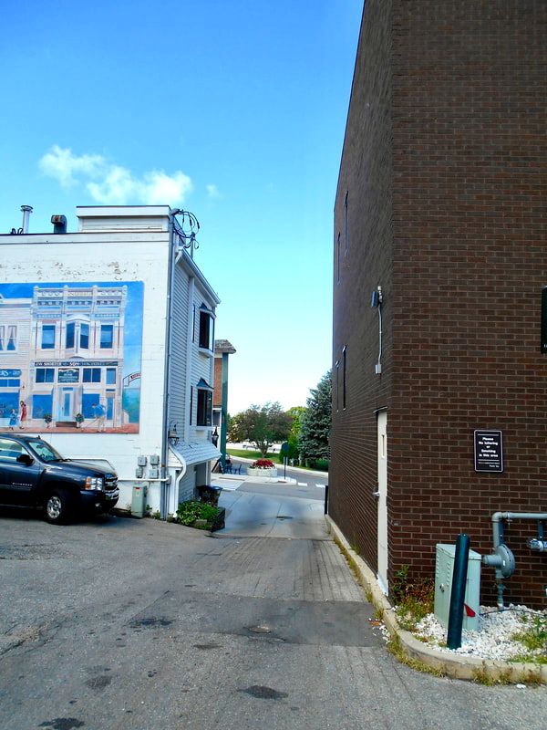
Photo Below: The boarded up window is on the end of the 322 Bay Street building as it butts up to the alley... Shoppers Lane. The red arrows point out the route of the alley and the narrowness of the alley as that route proceeds between the two existing buildings, exiting across the sidewalk on to Howard Street. All of the empty space to the right of the alley arrow belongs to the stores that front on to Lake Street (see GIS Map below the photo below). The space belongs to the property owners for their own parking needs. Cars for those properties can park right up to the alley, which would make a 90 degree turning radius extremely tight for vehicles; whether cars, service, or safety vehicles, needing to turn into the Bay Street Development facility.
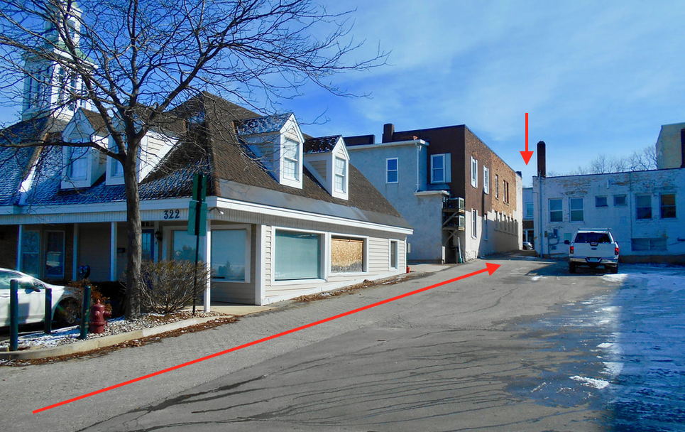
21 March 2020
Photos Below: The Lake Street businesses definitely use their own property
for vehicles to park adjacent to the alley.
for vehicles to park adjacent to the alley.
31 August 2012
22 July 2020
Photo Below: The narrow alley of Shoppers Lane
empties across the sidewalk directly on to Howard Street.
empties across the sidewalk directly on to Howard Street.

Captured July 2020 from Google Map Street View
Photo Below: The narrow alley of Shoppers Lane
empties across the sidewalk directly on to Bay Street.
empties across the sidewalk directly on to Bay Street.
23 July 2020
The GIS property outline map below illustrates just how narrow the Shoppers Lane alley (shown above) is, and how the Lake Street facing properties OWN the property that is directly adjacent to the rear alley.
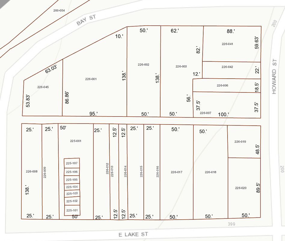
20 May 2020 ~ Emmet County GIS Property Map
AND.... so it begins
... with several similarities to Petoskey's ORIGINAL Hole
... with several similarities to Petoskey's ORIGINAL Hole
22 March 2020
Signs of the Second Hole Coming: The owners of Hole #1 either did not have their own money as in the case of David Jankowski and his cousin Michael Uzelec (Lake Street Associates); or the owner does not want to spend his own money as in the case of Mr. Berg who is pursuing “Transformational Brownfield” funding which literally has the taxpayers funding the development, while the owner reaps both the publicly funded construction phase, and the long term benefits. Even in 1991 Hole #1 property owner John Turner was hoping for assistance when his environmental consultant, Environmental Science and Engineering, Inc. had “found stuff” when an unknown substance had been discovered at the site of the recently demolished Petoskey Ford Dealership. By 2014 when Elias Amash owned Hole #1, his project team include Eric Helzer who was to focus on taxpayer funded incentive programs. In 2020 Mr. Berg already owned the previous parking property which the city mayor had signed away with the stroke of a pen in 2006. So, Mr. Berg needed no property from the city for Parking in his development plans, although he used parking as an enticement for city involvement in his development. Mr. Berg, however, pursued higher height limits than the city ordinance allowed, becoming quite verbal and revengeful about NOT “getting his way” for higher height limits. So, as of early 2020, Mr. Berg continues to saddle the city with Hole #1, although many residents have become accustomed to the hole, and actually prefer the hole, with its view, rather than the prospect of the proposed monumental monstrosity in the latest architects’ plans. The developer is the Holder of the Hole!
Multiple similarities between the two developmental proposals, foreshadow the Second Coming... Hole #2, IF the governmental entities do not take steps to preserve and protect the interests of the taxpaying residents: 1) Hole #1 in 2014, with then Hole owner Elias Amash, had the SAME architect as the architect for the 2020 proposed development on the corner of Howard and Bay streets. [UPDATE from 4 May 2020 Petoskey City Council Zoom Meeting: Bay Street Developers have placed Eric Helzer, Amash's "public fund seeker" to be a part of the Bay Street Team.] 2) Like Hole #1 the new proposed development site is owned by a multiple city property owner, Christopher Redding, who has a history with his properties of NOT having the best interests of the city. 3) The city actually owns the Saville Parking Lot (2 parcels) next door to Redding’s property which he wants to place restrictions for view easements, and thus own rights on the city’s Saville Lot; thus also gaining access to otherwise lacking, actually NON-Existent, underground parking for their own building development. The Saville Lot is the only planned ingress/egress opening to the developers' underground parking. This is comparable to Hole #1’s developers when the 2006 Mayor Meyer signed away, and gave away, almost a million dollars worth of city parking property for “the option” for the city to have some parking spaces in the Lake Street Associate’s doomed development [LATER: After various "morphings" for the hotel parking, a valet lift Jockey was one plan, but this is not positive as of July 2020 plans presented at the 21 July 2020 ECBOC meeting]. 3) With Hole #1, no one in the city required “performance and surety bonds” with a timeframe, or an amount of money put forth by the Original Hole developers. So, when Petoskey Pointe became Petoskey DISappointe, the developers were out nothing, and the city had absolutely nothing to show because of unintelligent decisions of those in governmental power.
Multiple similarities between the two developmental proposals, foreshadow the Second Coming... Hole #2, IF the governmental entities do not take steps to preserve and protect the interests of the taxpaying residents: 1) Hole #1 in 2014, with then Hole owner Elias Amash, had the SAME architect as the architect for the 2020 proposed development on the corner of Howard and Bay streets. [UPDATE from 4 May 2020 Petoskey City Council Zoom Meeting: Bay Street Developers have placed Eric Helzer, Amash's "public fund seeker" to be a part of the Bay Street Team.] 2) Like Hole #1 the new proposed development site is owned by a multiple city property owner, Christopher Redding, who has a history with his properties of NOT having the best interests of the city. 3) The city actually owns the Saville Parking Lot (2 parcels) next door to Redding’s property which he wants to place restrictions for view easements, and thus own rights on the city’s Saville Lot; thus also gaining access to otherwise lacking, actually NON-Existent, underground parking for their own building development. The Saville Lot is the only planned ingress/egress opening to the developers' underground parking. This is comparable to Hole #1’s developers when the 2006 Mayor Meyer signed away, and gave away, almost a million dollars worth of city parking property for “the option” for the city to have some parking spaces in the Lake Street Associate’s doomed development [LATER: After various "morphings" for the hotel parking, a valet lift Jockey was one plan, but this is not positive as of July 2020 plans presented at the 21 July 2020 ECBOC meeting]. 3) With Hole #1, no one in the city required “performance and surety bonds” with a timeframe, or an amount of money put forth by the Original Hole developers. So, when Petoskey Pointe became Petoskey DISappointe, the developers were out nothing, and the city had absolutely nothing to show because of unintelligent decisions of those in governmental power.
Lest we Forget… The City of Petoskey MUST continue its voice in this development’s plans by addressing ALL concerns. The City of Petoskey MUST require performance and surety bonds with this Howard and Bay streets proposed development, or surely the city will witness The Coming of the Second Hole. The city could reach the present predicament, and point, of the Original Hole, when this new project will have razed the present buildings, IF the city will have signed away their own present parking lot rights and ownership (by selling an air, view, and light, easement), AND, THEN, the developers were to decide to seek a higher height variance, or decide the development must have some other change; then, the city would be stuck with a Second Hole; thus trapped by the Holder of Hole #2. The Howard and Bay streets developer, like Mr. Berg, could give the city The Hole Ultimatum... either give the new developers what they want at that point, OR be stuck with the Second Hole. The developer/owner will be the Holder of Hole #2.
The Howard and Bay streets development was brought forward on the 9 March 2020 meeting agenda of the Emmet County Brownfield Redevelopment Authority (BRA). Brownfield Consultant Mac McClelland was in attendance (as well as the city's planner Tweeten) and McClelland has been paid multiple times for similar, and sometimes the very same issue (playing the same game siphoning taxpayer dollars, but just playing with a different deck of cards). When McClelland was asked by a public attendee about a concern, the entire conversation was halted by a BRA member. The public taxpayer sought answer as to whom would actually be applying for the Brownfield grants for the Howard and Bay streets development; as it is not clear because the pieces of property are owned individually by Christopher Redding, AND, the City of Petoskey; and, represented by the architect Polzin, with listed developers being Main Dock 7271 which is made up of residents of Bear Creek Township. They are prospective developers who own other buildings and businesses on Mackinac Island and Hillman, Michigan. To learn the Brownfield process, it was asked WHICH interested party would be responsible for any Brownfield Phase 1 application. Also, then IF any environmental issues are discovered that would require remediation, whether those parties understand that it is the property owner’s responsibility to pay that cost up front. Thus, it was important to know who was the cost paying applicant. The Brownfield Redevelopment Authority members were not interested in learning about any of this, when it was brought up in public comment, but rather said the meeting needed to end, so one member could get to another meeting! That vocalization is not reflected in the minutes below. So much for a committee member or any attendee researching a topic, or actually learning about the topic from anyone else, and/or any transparency in a public meeting!
The Howard and Bay streets development was brought forward on the 9 March 2020 meeting agenda of the Emmet County Brownfield Redevelopment Authority (BRA). Brownfield Consultant Mac McClelland was in attendance (as well as the city's planner Tweeten) and McClelland has been paid multiple times for similar, and sometimes the very same issue (playing the same game siphoning taxpayer dollars, but just playing with a different deck of cards). When McClelland was asked by a public attendee about a concern, the entire conversation was halted by a BRA member. The public taxpayer sought answer as to whom would actually be applying for the Brownfield grants for the Howard and Bay streets development; as it is not clear because the pieces of property are owned individually by Christopher Redding, AND, the City of Petoskey; and, represented by the architect Polzin, with listed developers being Main Dock 7271 which is made up of residents of Bear Creek Township. They are prospective developers who own other buildings and businesses on Mackinac Island and Hillman, Michigan. To learn the Brownfield process, it was asked WHICH interested party would be responsible for any Brownfield Phase 1 application. Also, then IF any environmental issues are discovered that would require remediation, whether those parties understand that it is the property owner’s responsibility to pay that cost up front. Thus, it was important to know who was the cost paying applicant. The Brownfield Redevelopment Authority members were not interested in learning about any of this, when it was brought up in public comment, but rather said the meeting needed to end, so one member could get to another meeting! That vocalization is not reflected in the minutes below. So much for a committee member or any attendee researching a topic, or actually learning about the topic from anyone else, and/or any transparency in a public meeting!
Below are the DRAFT minutes for the 12 March 2020 ECBRA meeting, with a good summary of the discussion, but lacking in the essence when the end commenter was, cut off, and directed to talk with staff LATER... with no need, evidently, for the city planner, the BRA consultant, nor the BRA members to actually learn anything regarding the Brownfield Project Applicant requirements, whomever the applicant truly is.
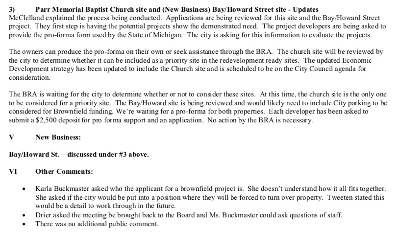
DRAFT minutes for the 12 March 2020 ECBRA meeting posted on this web page on 1 April 2020...
It is not understood WHY the ECBRA, or city, owner/development people would be spending time on this topic as related to Brownfield funding, if that path only leads to a Second Hole. Ask questions (or at least, listen to the answers to the questions of others). Listen. Learn... BEFORE making decisions; BEFORE shutting down discussion of a topic at an open meeting.
In simple terms... For the government assistance through Brownfield funding to transpire, do the properties of the proposed development need to be ONE consolidated property; thus requiring the city to "sign over" the city's two properties (or any portion thereof, like an "air easement") that make up the Saville Lot? IF so, then, once those properties are signed over, the city will have placed itself in the exact same situation as in 2006 with the ORIGINAL HOLE. This action would perpetuate the launch for "The Hole ~ Second Coming."
In simple terms... For the government assistance through Brownfield funding to transpire, do the properties of the proposed development need to be ONE consolidated property; thus requiring the city to "sign over" the city's two properties (or any portion thereof, like an "air easement") that make up the Saville Lot? IF so, then, once those properties are signed over, the city will have placed itself in the exact same situation as in 2006 with the ORIGINAL HOLE. This action would perpetuate the launch for "The Hole ~ Second Coming."
2 March 2020 City Council Meeting Minutes reveal a change of plans for the
Bay/Howard Street Development, but no drawn plans accompanied the minutes written below.
Bay/Howard Street Development, but no drawn plans accompanied the minutes written below.
2 March 2020 ~ Petoskey City Council Meeting Minutes
The above 2 March 2020 statement of plan obviously must have been only for "the purpose of confusion," as the plan differs from previous 17 February 2020 plans presented by Polzin's letter toward the top of this page. AND this 2 March 2020 plan is certainly different from the 4 May 2020 plan that follows below for a 50 room boutique hotel, with no residential or commercial components!
Material items below are from the public packet for the 4 May 2020 Petoskey City Council meeting.
Imagine a developer that came to town, striving only to build on his own property, according to prevailing ordinances; not asking for a governmental (taxpayer) handout through Brownfields, Grants, TIFs, seizing of public property, or such. After all, it will be the developer who reaps the long term benefits of the money invested into the project, not the taxpayers. The Bay Street Development developer's proposed timeline has the developer beginning to build in September 2020 and being ready for the business season in June 2021... trying to instill a time constraint for action from the city, and other governmental entities, like the Emmet County Brownfield Authority which has already been involved as noted farther above. Not having to wait for easement approval, or Brownfield eligibility, the developer's construction phase certainly could begin in September, or sooner. This imagined developer could be in control of the Bay Street Development, and just move forward at the developer's own volition... BUT NO!
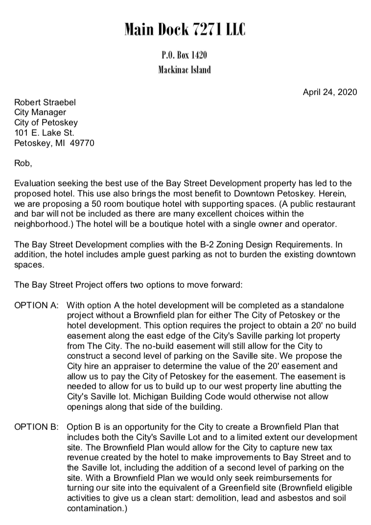
Letter dated 24 April 2020 from Main Dock 7271 LLC to Petoskey's City Manager Robert Straebel (included with the packet for the 4 May 2020 Petoskey City Council meeting) continued below with the second page of this letter...
Letter dated 24 April 2020 from Main Dock 7271 LLC to Petoskey's City Manager Robert Straebel (included with the packet for the 4 May 2020 Petoskey City Council meeting) continued from above first page of letter...
Letter Above from the Developer Main Dock 7271 LLC to City Manager Straebel referenced:
The Developer's Architect Polzin' 17 February 2020 letter shown toward the top of this web page addressed to the city council packet states: “This proposed redevelopment will transform this underutilized location into new viable commercial space and 20 new attractive residential living spaces,” answering the city’s need for housing, and commercial spaces. BUT NOW, with the developer's "foot in the door," the plan, according to the same developer's architect's above 24 April 2020 letter is for a 50 room “boutique” hotel! [See six architectural comparison drawings below. Click drawings to enlarge.]
The Developer's Architect Polzin' 17 February 2020 letter shown toward the top of this web page addressed to the city council packet states: “This proposed redevelopment will transform this underutilized location into new viable commercial space and 20 new attractive residential living spaces,” answering the city’s need for housing, and commercial spaces. BUT NOW, with the developer's "foot in the door," the plan, according to the same developer's architect's above 24 April 2020 letter is for a 50 room “boutique” hotel! [See six architectural comparison drawings below. Click drawings to enlarge.]
~ MORPH ~
Apartment Building to Boutique Hotel
Apartment Building to Boutique Hotel
Two Drawings Below of MAIN Entry Level with LOWER Level Development Parking:
Left Below: Plans for 20 new attractive RESIDENTIAL APARTMENTS and four COMMERCIAL spaces.
Right Below: Plans for NO apartments and no commercial spaces; all space is HOTEL associated.
Left Below: Plans for 20 new attractive RESIDENTIAL APARTMENTS and four COMMERCIAL spaces.
Right Below: Plans for NO apartments and no commercial spaces; all space is HOTEL associated.
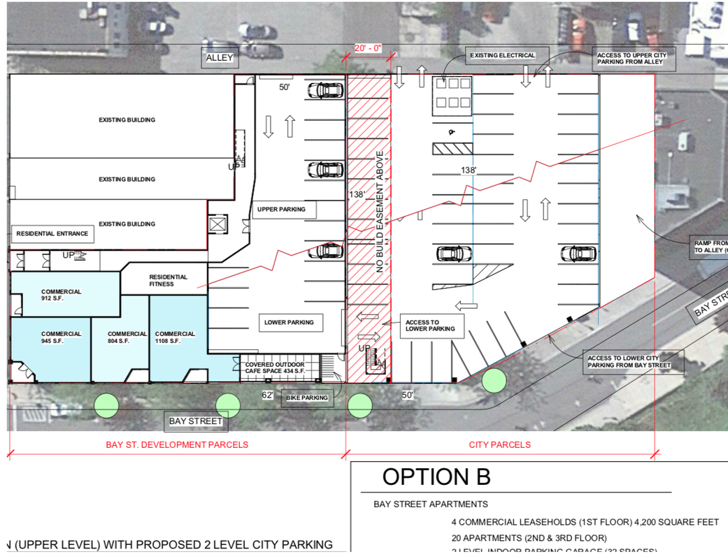
APARTMENT and COMMERCIAL Architectural Drawing dated 17 February 2020 Petoskey City Council meeting...
|
Changed to HOTEL Architectural Drawing dated 28 April 2020...
|
Two Drawings Below:
Plans for 20 new attractive RESIDENTIAL APARTMENTS on second and third floors
Plans for 20 new attractive RESIDENTIAL APARTMENTS on second and third floors

Developer's Architect Polzin's 17 February 2020 residential housing drawing...
|
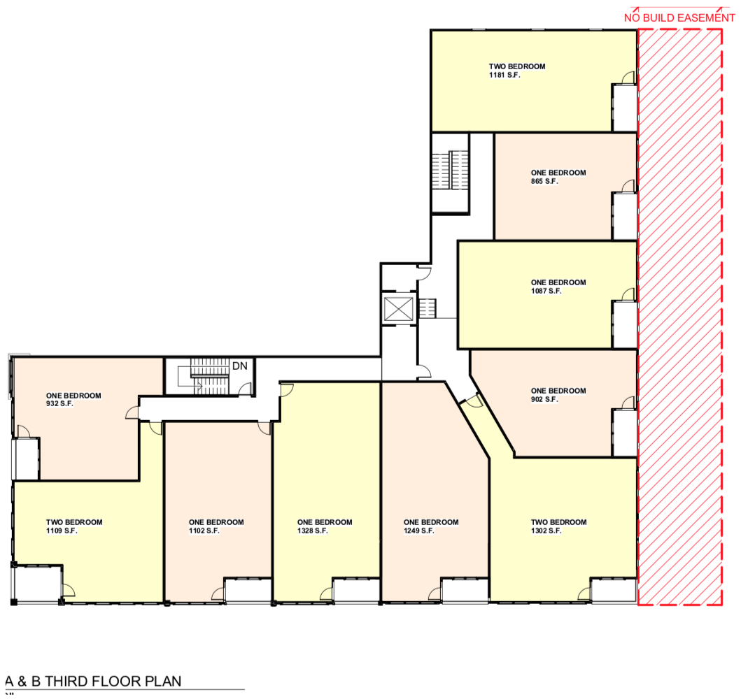
Developer's Architect Polzin's 17 February 2020 residential housing drawing...
|
Two Drawings Below:
Plans for 50 "boutique" HOTEL ROOMS on second and third floors
Plans for 50 "boutique" HOTEL ROOMS on second and third floors
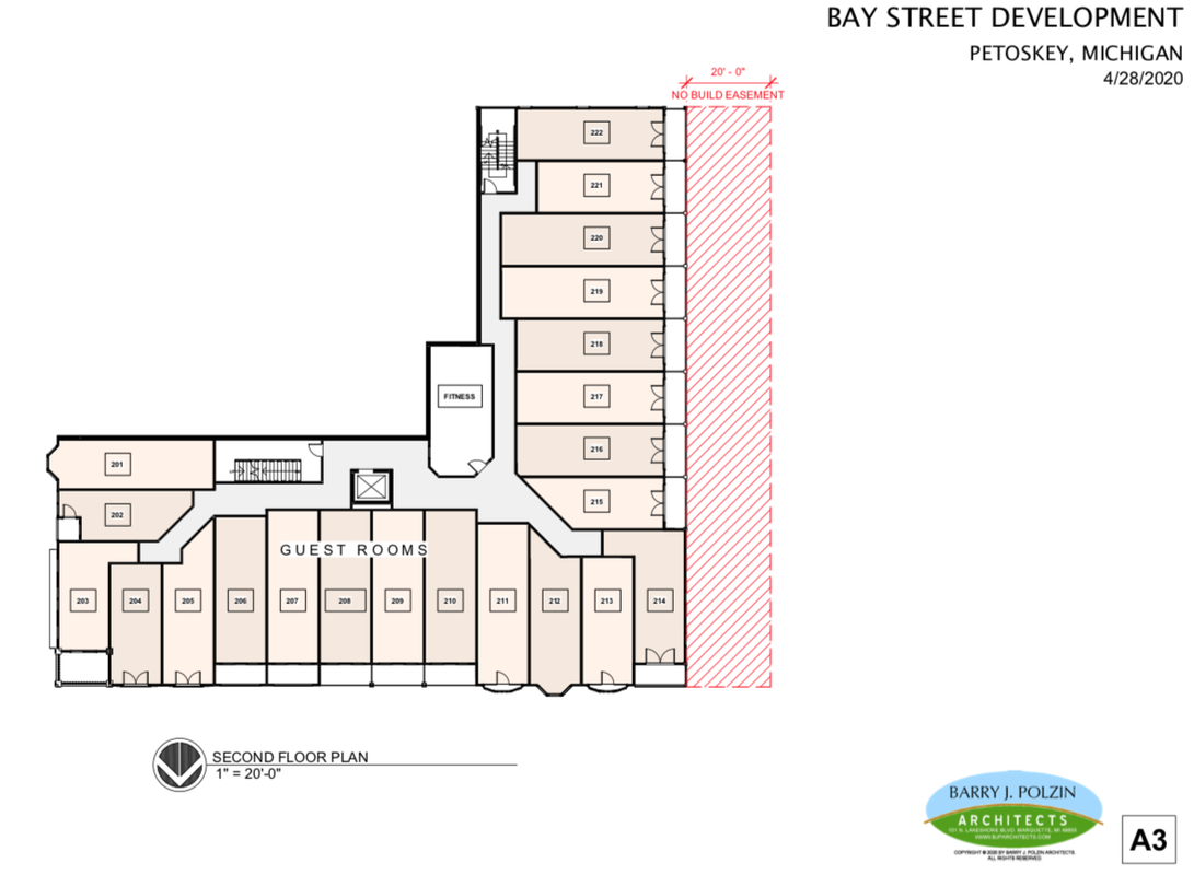
Developer's Architect Polzin's 24 Aparil 2020 residential hotel room drawings...
|
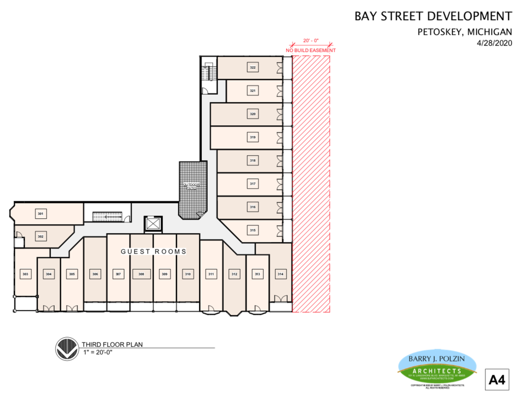
Developer's Architect Polzin's 24 Aparil 2020 residential hotel room drawings...
|
Letter Above from the Developer Main Dock 7271 LLC to City Manager Straebel referenced:
While architectural DESIGN style of the proposed 50 room boutique hotel seems appropriate to the surroundings, although lacking commercial spaces... the letter appears to offer two OPTIONS, with the city being asked to become linked FOREVER through either, or both options.
OPTION A attaches the city to the Bay Street Development by the city giving up 20 feet of adjacent air property with no guarantees of reimbursement or proposed use… the city’s attorney James J. Murray (see his letter below) is advising, however, that the granting of the easement is not legal. Rather, the city would have to sell the 20 feet of city property to the developer. Once that sale transpires, the property is gone FOREVER, just like the city’s property was signed over for Hole #1, with nothing but an OPTION for paying millions of dollars to fund and incorporate a part of a parking structure. But, that Hole #1 OPTION never developed so the city lost that property FOREVER. IF the Bay Street developer wishes to have a 20 foot buffer between the development property and the city's property, then the developer should set back the top two floors of the hotel 20 feet; back on to the developer's own property and create on the lower two floors the access to the proposed private parking under the hotel. Be creative with the appropriate architectural design and just move forward under the developer's own volition.
City Attorney James J. Murrays advisement letter regarding the city granting a 20-foot air easement to the developers...
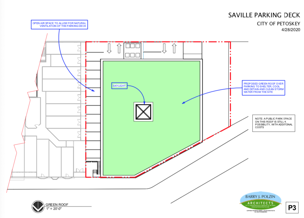
OPTION B offers the city the "opportunity" to become involved with a Brownfield plan that would capture CITY taxes, PLUS COUNTY taxpayer dollars, and STATE tax dollars for about 15 years... money that would otherwise go to tax funded education, health, safety and roads; rather than being directed into the MEDC fund bank. This OPTION B involves more entities than just the city! Below is the Brownfield Plan proposed by the Bay Street developers. OPTION B, however, includes the city making a commitment to spend an additional $3,146,386 for a Parking Structure (shown only two stories high in the developer's drawing). The city already has the ground level layer of parking in the city's Saville Lot, so the 3+million dollars (plus 15 years of captured taxes) would buy for the city, after the 20 foot easement, only a portion of a second layer of parking. NOT a deal for the taxpayers. UPDATE: Also, a team member of the developer's team stated that if the city wanted to include the performance park on the roof of the second parking level, that cost would be additional to the plan below.

Notice of Request on 24 April 2020 from Main Dock 7271 LLC for consideration from the City of Petoskey to agree to Brownfield Tax Increment Financing (TIF) Plan
Agenda Memo prepared 30 Aoril 2020 (included with the packet for the 4 May 2020 Petoskey City Council meeting) continued below with the second page of this memo...
Agenda Memo prepared 30 Aoril 2020 (included with the packet for the 4 May 2020 Petoskey City Council meeting) continued from above first page of this memo...
TOP
~ MORPH ~
Easement demension measurements
Easement demension measurements
Agenda Memo Above: Looking at the provided drawing labeled "Aerial View" with "20’ No Build Easement" shown… 1) the 20 feet start 18 feet above grade on Bay Street; so consider how many feet above grade the 20 feet easement extends when it reaches the back Shoppers Lane (See Second Drawing Below). This would be important for the city to know IF it might consider building a parking structure there in the future. So how could cars park there, or would the first level of the structure be underground, after excavation? Then the city would be committing an underground layer of property as well. The perspective of the drawings showing the west side does not seem quite right. The measurements for the "air easement" in the Agenda Memo are 20’ x 24’ x 138’ (starting 18 feet above grade on Bay Street). The measurements for the SAME "air easement" on the Architectural drawing are 20’ x 21'.4" x 138’ (starting 21.4" above grade on Bay Street). Which measurement is accurate; the Agenda Memo (24') OR the Architectural Drawing (21'4")?
FOLLOW–UP: During the 4 May 2020 ZOOM city council meeting City Manager Strabel hesitated while reading aloud the figures he had written in the Agenda Memo as questioned above. He audibly changed his 24' above grade level on Bay Street, to the 21'4" feet above grade level on Bay Street as shown below... however, the drawing below does not make the top and the bottom 21'4" believable when lined up against the heights of the individual hotel floor levels. Something seems out of whack to the average eye with the measurements.
FOLLOW–UP: During the 4 May 2020 ZOOM city council meeting City Manager Strabel hesitated while reading aloud the figures he had written in the Agenda Memo as questioned above. He audibly changed his 24' above grade level on Bay Street, to the 21'4" feet above grade level on Bay Street as shown below... however, the drawing below does not make the top and the bottom 21'4" believable when lined up against the heights of the individual hotel floor levels. Something seems out of whack to the average eye with the measurements.
Drawing by Architect Polzin showing the North Elevation of the development with the confusing measurements of the height of the 20' No Build Easement.
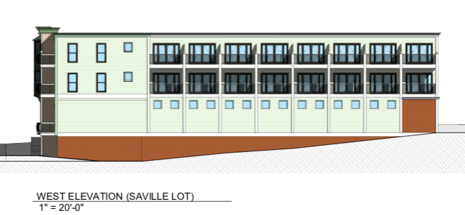
Drawing by Architect Polzin showing the West Elevation of the city's Saville Lot running up hill grade from Bay Street to the Shopper's Lane (Alley)
Agenda Memo Above (Comments Continued From Above):
2) The staff understandably have concerns about the access to the on-site underground parking through Saville Lot and the loss of parking sites. Consider also that if the development uses alley access that the alley is very narrow and would require an extremely tight turning radius. Although in photos it may look like the alley is wide in spots, the stores that front Lake Street have properties that run to the alley ingress/egress. While sometimes the store properties near the alley look empty, the properties do belong to the stores for their own parking needs. In viewing the alley's south elevation drawing below, the three wide door entries are either extremely short adding to the tight turning radius, or the entire alley grade level will need to be changed in some manner, affecting every building and property adjacent to the alleyway. The larger of the three doors is labeled on another drawing sheet as "Deliveries and trash inside via valet parking entrance," AND "Entrance to upper parking from alley at grade 633'.0" immediately accessing a "car lift." The architect labels the Bay Street grade level at 625.0.
2) The staff understandably have concerns about the access to the on-site underground parking through Saville Lot and the loss of parking sites. Consider also that if the development uses alley access that the alley is very narrow and would require an extremely tight turning radius. Although in photos it may look like the alley is wide in spots, the stores that front Lake Street have properties that run to the alley ingress/egress. While sometimes the store properties near the alley look empty, the properties do belong to the stores for their own parking needs. In viewing the alley's south elevation drawing below, the three wide door entries are either extremely short adding to the tight turning radius, or the entire alley grade level will need to be changed in some manner, affecting every building and property adjacent to the alleyway. The larger of the three doors is labeled on another drawing sheet as "Deliveries and trash inside via valet parking entrance," AND "Entrance to upper parking from alley at grade 633'.0" immediately accessing a "car lift." The architect labels the Bay Street grade level at 625.0.
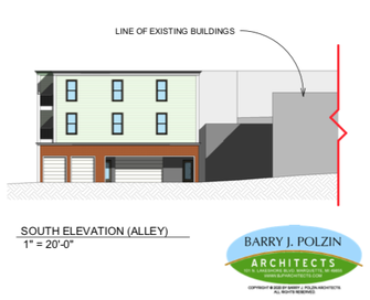
Drawing by Architect Polzin showing the South Elevation of the development with the rather short door entries...
Agenda Memo Above (Comments Continued From Above):
3) The architectural plan has a label pointing to the corner of Bay and Howard streets: "Guest Drop Off/Valet Parking Spot" right on the street. This needs clarification, IF this following statement from the Petoskey Ordinances is still in effect: "Drive-through and drive-up accessory or principal uses are not allowed."
3) The architectural plan has a label pointing to the corner of Bay and Howard streets: "Guest Drop Off/Valet Parking Spot" right on the street. This needs clarification, IF this following statement from the Petoskey Ordinances is still in effect: "Drive-through and drive-up accessory or principal uses are not allowed."
After the above mentioned 4 May 2020 Petoskey City Council Zoom meeting convened the Petoskey News Review reported in an updated corrected on-line version of the article titled "Petoskey to begin early analysis of Bay Street development":
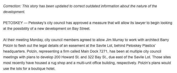
Parking was NOT mentioned in the above article, but during the 4 May 2020 ZOOM city council meeting: Architect Polzin stated that the new Hotel Plan has 50 parking spaces for the 50 guest rooms, "within its own property, and thus does not need city parking, nor parking entry from the Saville Lot as was shown in the first plan. This Hotel Plan will use a car lift and 'valet jockey' parking."
LATER: During the 05/18/20 City Council ZOOM meeting the limited parking spaces (NOT the 50 touted above) for the hotel were questioned. Architect Polzin stated the hotel will have "valet jockeys" who will park vehicles in the "drive lanes and such." Does that type parking plan meet building codes, and safety codes?
LATER: During the 05/18/20 City Council ZOOM meeting the limited parking spaces (NOT the 50 touted above) for the hotel were questioned. Architect Polzin stated the hotel will have "valet jockeys" who will park vehicles in the "drive lanes and such." Does that type parking plan meet building codes, and safety codes?
Two 28 April 2020 Drawings Below of the Main Level Parking (Left) and Lower Level Parking (Right)
The Main Level parking has maybe 17 parking spaces (count them).
The Lower Level states on the plan that 27 spaces of valet parking are available (count them).
The Lower Level states on the plan that 27 spaces of valet parking are available (count them).

28 April 2020 ~ Drawing by Architect Polzin showing the MAIN LEVEL of the hotel and the upper valet parking...
|
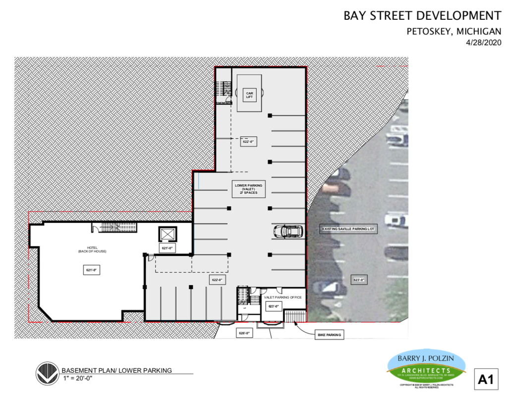
28 April 2020 ~ Drawing by Architect Polzin showing the BASEMENT Plan/lower parking...
|
~ MORPH ~
Developer's Brownfield Consultant rather than County's Consultant
Developer's Brownfield Consultant rather than County's Consultant
During the same 4 May 2020 city council Zoom meeting as noted above, Eric Helzer, an unannounced guest speaker, spoke to the council members, the city manager, and the mayor, regarding the advantages of public funding involvement. After council member Walker asked who he was, he revealed that he was a part of the developer's team for Bay Street Development. His pronouncements were reminiscent of the same Eric Helzer's involvement in Hole #1 when the then owner Elias Amash announced Helzer's role on Amash's team, at the same time that Amash's architect was Mr. Barry Polzin. As a reminder, this pertinent information is quoted exactly (in green color) below from a 2014 Petoskey News Review issue. The article tells of the many roles Eric Helzer was to play in Hole #1, a foreshadowing, perhaps of "The Hole, Second Coming;" of his role in the Bay Street Hotel as he briefly conveyed in his Zoom proffering. View this same portion shown below from the total article by clicking HERE, PLUS additional information about Hole #1 by clicking HERE.
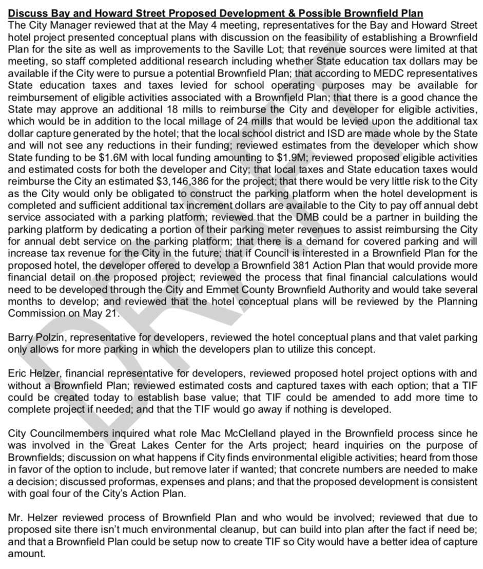
During the 4 May 2020 Zoom meeting and in their written documents, it was very interesting that the developers, and the city manager, both emphasized with the Hotel Plan that “the developers are not requesting Brownfield funding on the project nor any other economic incentive.” Council member Marshall rightfully expressed she found it “disconcerting” that after considerable listening to how a Brownfield was NOT needed for the project, that yet all of the talk during the discussion [which included Eric Helzer's pitch] was talking of reasons it would be good to HAVE a Brownfield, and what the city would be losing by not having a Brownfield.
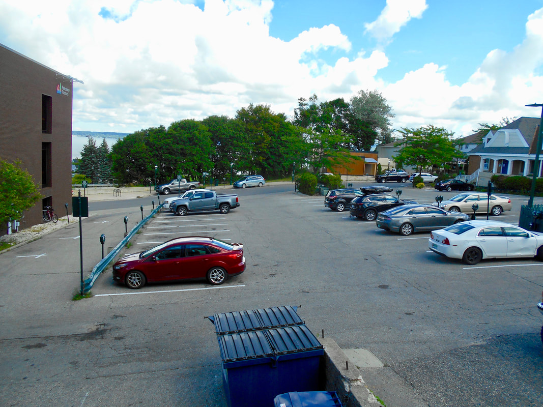
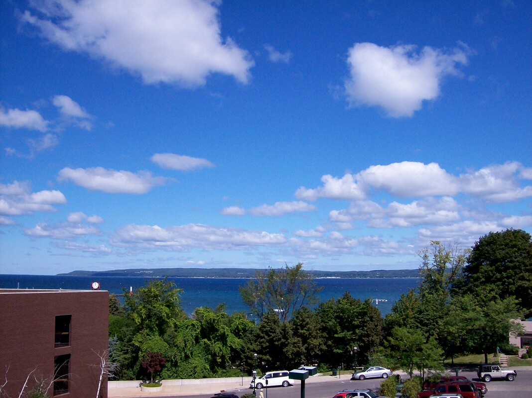
Mrs. Marshall also expressed during discussion about the possibilities for the city “in the future” of maybe wanting to work with a developer who might be interested in creating condominiums or such on top of a city parking structure, and by then the city already may have parlayed away their own property interests. She voiced that without the present Brownfield, the city still could collect the taxes on the present proposed project, and could use that money toward building a parking structure when the timing was right for the city. Helzer said that is correct, but the city may lose out on state (possibly he meant MEDC funding, because it is separate from State funds) money for help to build a structure as a different project. It is hard to understand, however, if that city property NOW qualifies for a Brownfield, why would it not qualify in the future? All of that would be possible even without giving up any of the city’s property opportunities via selling a 20 feet air easement. [Five Photos Below: 1)This vantage of bay view was taken only at about a 1 1/2 level above where a parking structure might exist. Regarding Mrs. Marshall statement above about a possible third floor above a parking structure, this view of the bay could not be beat for housing or businesses. Why would the city consider giving up that opportunity and the treasure of a view they currently own? 2) This 2006 photo was taken from a third floor patio at Papa Lou's. 3, 4, and 5) Also from Papa Lou's in 2012 showing an expansive view that remains. 6) Papa Lou's ~ No longer that business name ~ outside third story deck where photos were taken. ]
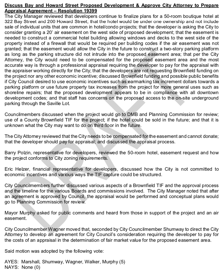
The council members did approve for a contract to be drawn up for the developer to pay to have an appraisal done for the 20 feet air easement. At the same time the developer’s plan will be sent to the city planning commissioners for their input to the council. The developer and the architect, and Eric Helzer will be patient because they have played this same game before, right in Petoskey [HOLE #1], and they know their ultimate goal is much more than them having to pay for an appraisal which will be a reimbursable expense (an eligible activity) for the developer once the Brownfield proceeds.
The snare has been set… what will be the next step that the planning commissioners and the council members will take?
Mrs. Marshall also expressed during discussion about the possibilities for the city “in the future” of maybe wanting to work with a developer who might be interested in creating condominiums or such on top of a city parking structure, and by then the city already may have parlayed away their own property interests. She voiced that without the present Brownfield, the city still could collect the taxes on the present proposed project, and could use that money toward building a parking structure when the timing was right for the city. Helzer said that is correct, but the city may lose out on state (possibly he meant MEDC funding, because it is separate from State funds) money for help to build a structure as a different project. It is hard to understand, however, if that city property NOW qualifies for a Brownfield, why would it not qualify in the future? All of that would be possible even without giving up any of the city’s property opportunities via selling a 20 feet air easement. [Five Photos Below: 1)This vantage of bay view was taken only at about a 1 1/2 level above where a parking structure might exist. Regarding Mrs. Marshall statement above about a possible third floor above a parking structure, this view of the bay could not be beat for housing or businesses. Why would the city consider giving up that opportunity and the treasure of a view they currently own? 2) This 2006 photo was taken from a third floor patio at Papa Lou's. 3, 4, and 5) Also from Papa Lou's in 2012 showing an expansive view that remains. 6) Papa Lou's ~ No longer that business name ~ outside third story deck where photos were taken. ]
The council members did approve for a contract to be drawn up for the developer to pay to have an appraisal done for the 20 feet air easement. At the same time the developer’s plan will be sent to the city planning commissioners for their input to the council. The developer and the architect, and Eric Helzer will be patient because they have played this same game before, right in Petoskey [HOLE #1], and they know their ultimate goal is much more than them having to pay for an appraisal which will be a reimbursable expense (an eligible activity) for the developer once the Brownfield proceeds.
The snare has been set… what will be the next step that the planning commissioners and the council members will take?
22 July 2020
|
17 August 2006
|
31 August 2012
|
31 August 2012
|

31 August 2012
|

22 July 2020
|
~ 4 May 2020 Petoskey City Council meeting DRAFT minutes ~
4 May 2020 ~ DRAFT minutes from the City Council ZOOM Meeting
~ MORPH ~
"No Build" Easement to
"Air" and "View" Easement
"No Build" Easement to
"Air" and "View" Easement
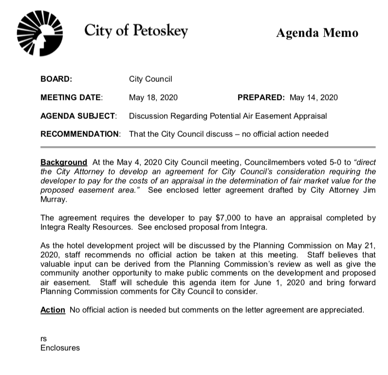
Per Above Agenda Memo: In preparation for the 18 May 2020 City Council meeting
City Attorney Jim Murray prepared the following "letter agreement"
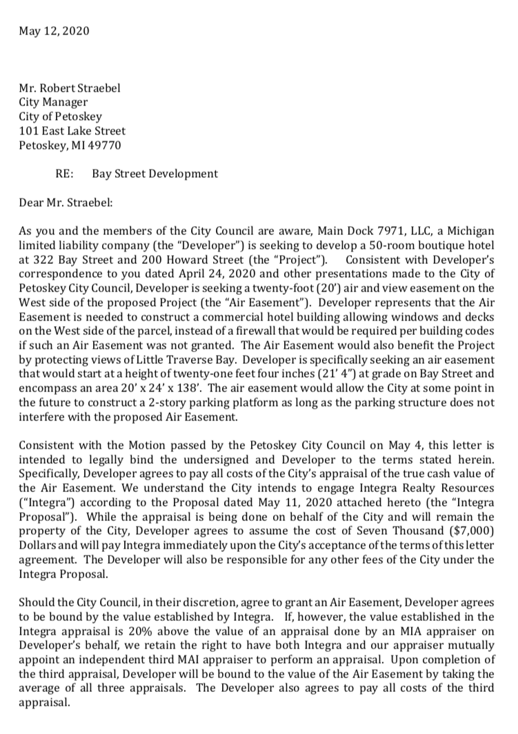
Main Dock 7971 LLC letter (shown below) dated 12 May 2020 to City Manager Strabel.
City Attorney Jim Murray prepared the following "letter agreement"
Main Dock 7971 LLC letter (shown below) dated 12 May 2020 to City Manager Strabel.
In preparation for the 18 May 2020 City Council meeting Petoskey City Attorney Jim Murray prepared the above "letter agreement" (continued below) ~
Main Dock 7971 LLC letter dated 12 May 2020 to City Manager Strabel.
In preparation for the 18 May 2020 City Council meeting Petoskey City Attorney Jim Murray prepared the above "letter agreement" (continued from above) ~
Main Dock 7971 LLC letter dated 12 May 2020 to City Manager Strabel.
In preparation for the 18 May 2020 City Council meeting Main Dock 7971 LLC wrote the letter (shown above) dated 12 May 2020 to City Manager Strabel which stated:
"Consistent with Developer’s correspondence to you dated April 24, 2020 and other presentations made to the City of Petoskey City Council, Developer is seeking a twenty-foot (20’) air and view (not red nor underlined in actually letter) easement on the West side of the proposed Project (the “Air Easement”). Developer represents that the Air Easement is needed to construct a commercial hotel building allowing windows and decks on the West side of the parcel, instead of a firewall that would be required per building codes if such an Air Easement was not granted. The Air Easement would also benefit the Project by protecting views of Little Traverse Bay. The air easement would allow the City at some point in the future to construct a 2-story parking platform as long as the parking structure does not interfere with the proposed Air Easement."
Before the above statement, the developer's proposal was for a vertical air easement (thus not requiring a fire wall for the hotel) which still would have allowed the city in the future to build a structure that might have commercial on the ground floor, and two floors (or more) of parking above. With the developer's inclusion in the agreement above of a VIEW EASEMENT, however, the city would never be allowed to construct any structure higher than 21'4" from grade level (as shown in the developer's plans above*) on the city's own property... that is; what property that might be left and will not have been signed away with the stroke of a pen. Will the developer's easement also soon include a LIGHT easement, meaning any future structure that the city may wish to construct on the Saville Lot could not be high enough to block LIGHT entering the air space easement. These types of easements are commonly categorized as "negative easements." Negative easements restrain servient landowners from making otherwise lawful uses of their own property.
*The developer's plans have a tendency to MORPH (like a residential development into a 50 room hotel)... Their plans above show that the air easement was to be 20x21.4x138, but their most recent 12 May 2020 letter states the air/view space had grown to 20x24x138. So, is the air/view space extending farther above the actual hotel structure, or cutting off ground space from the city's property?
Here is where the snare may tighten... IF the city were to sign over the 20 feet Air/View/Light easement, the city will have cut off many uses of its own property. Once the developer owns the easement space, the developer calls the shots, whether the city builds anything or not. So, the Bay Street developer could say, oh... we want just a bit more height on our hotel, because they ultimately own ALL the space above the legal easement space. Either the city must give in to the developer's new demands; forget about height restrictions, or any other ordinances, or the city can be stuck with HOLE #2!
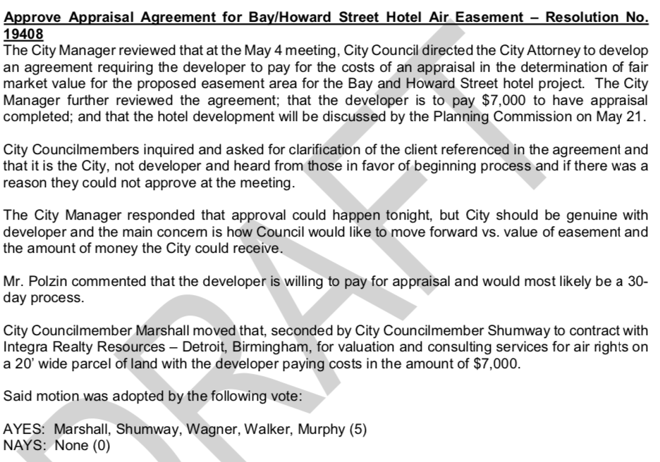
The city has chosen appraiser Integra Reality Resources of Birmingham, Michigan, to perform the Subject: Proposal/Authorization for Valuation and Consulting Services Air Rights on a 20 Foot wide parcel of land. Throughout its submitted papers, Integra refers to the "client." Is the client the city (seeker of the appraisal) or is the client the developer (payer of the appraisal)? UPDATE: The city is the "client."
"Consistent with Developer’s correspondence to you dated April 24, 2020 and other presentations made to the City of Petoskey City Council, Developer is seeking a twenty-foot (20’) air and view (not red nor underlined in actually letter) easement on the West side of the proposed Project (the “Air Easement”). Developer represents that the Air Easement is needed to construct a commercial hotel building allowing windows and decks on the West side of the parcel, instead of a firewall that would be required per building codes if such an Air Easement was not granted. The Air Easement would also benefit the Project by protecting views of Little Traverse Bay. The air easement would allow the City at some point in the future to construct a 2-story parking platform as long as the parking structure does not interfere with the proposed Air Easement."
Before the above statement, the developer's proposal was for a vertical air easement (thus not requiring a fire wall for the hotel) which still would have allowed the city in the future to build a structure that might have commercial on the ground floor, and two floors (or more) of parking above. With the developer's inclusion in the agreement above of a VIEW EASEMENT, however, the city would never be allowed to construct any structure higher than 21'4" from grade level (as shown in the developer's plans above*) on the city's own property... that is; what property that might be left and will not have been signed away with the stroke of a pen. Will the developer's easement also soon include a LIGHT easement, meaning any future structure that the city may wish to construct on the Saville Lot could not be high enough to block LIGHT entering the air space easement. These types of easements are commonly categorized as "negative easements." Negative easements restrain servient landowners from making otherwise lawful uses of their own property.
*The developer's plans have a tendency to MORPH (like a residential development into a 50 room hotel)... Their plans above show that the air easement was to be 20x21.4x138, but their most recent 12 May 2020 letter states the air/view space had grown to 20x24x138. So, is the air/view space extending farther above the actual hotel structure, or cutting off ground space from the city's property?
Here is where the snare may tighten... IF the city were to sign over the 20 feet Air/View/Light easement, the city will have cut off many uses of its own property. Once the developer owns the easement space, the developer calls the shots, whether the city builds anything or not. So, the Bay Street developer could say, oh... we want just a bit more height on our hotel, because they ultimately own ALL the space above the legal easement space. Either the city must give in to the developer's new demands; forget about height restrictions, or any other ordinances, or the city can be stuck with HOLE #2!
The city has chosen appraiser Integra Reality Resources of Birmingham, Michigan, to perform the Subject: Proposal/Authorization for Valuation and Consulting Services Air Rights on a 20 Foot wide parcel of land. Throughout its submitted papers, Integra refers to the "client." Is the client the city (seeker of the appraisal) or is the client the developer (payer of the appraisal)? UPDATE: The city is the "client."
DRAFT minutes below from the 18 May 2020 Petoskey City Council meeting verifying that the Letter of Appraisal Agreement was approved. The letter of agreement stated the Developer is seeking a twenty-foot (20’) air and view (not red nor underlined in actually letter) easement on the West side of the proposed Project (the “Air Easement”).
DRAFT minutes from the 18 May 2020 Petoskey City Council meeting verifying that the Letter of Appraisal Agreement was approved.
**The Council approved moving forward with the appraisal contract for the air easement.
The mayor restated the motion made by Mrs. Marshall as," Move forward with the agreement on the assessment [probably meant appraisal].
Architect Barry Polzin chimed in that "Melanie and Ira are in agreement with the letter [assumed he meant the letter of agreement prepared by the city attorney as shown above, talking of an "air" AND "view" easement].
** At this point the City Council, on 18 May 2020, agreed unanimously to move forward on the appraisal, while at the same time sending the plans for the development and the proposed easement on to the city planning commission for their recommendations.
Although Council member Marshall expressed concern when talking of Brownfields/TIFs regarding the funds being derived from School Taxes, she was told by Eric Helzer that while the money comes from the school taxes, the State will make the schools whole.
Michigan.Gov
Where does TIF come from?
State school taxes (24 mills)
Local School Operating Tax ((18 mills)
State Education Tax (6mills)
Local Taxes
~~~~~~~~~~~~~~~~~~~
Where does TIF come from?
Must occur on eligible property that is included in locally approved Brownfield Plan
Debt millages are not allowed to be captured.
Does not take money away from schools, just defers increase (NOT the same as saying "the state makes the schools whole.")
Where does TIF come from?
State school taxes (24 mills)
Local School Operating Tax ((18 mills)
State Education Tax (6mills)
Local Taxes
~~~~~~~~~~~~~~~~~~~
Where does TIF come from?
Must occur on eligible property that is included in locally approved Brownfield Plan
Debt millages are not allowed to be captured.
Does not take money away from schools, just defers increase (NOT the same as saying "the state makes the schools whole.")
DRAFT minutes from the 18 May 2020 Petoskey City Council meeting page 8 and 9 tell some of the discussion including the Possible Brownfield Plan for the Bay and Howard Streets Proposed development.
DRAFT minutes from the 18 May 2020 Petoskey City Council meeting page 8
DRAFT minutes from the 18 May 2020 Petoskey City Council meeting page 9
~ MORE MORPHING and a New Plan Review ~
The 21 May 2020 City Planning Commission meeting AGENDA MEMO (exactly as written)
for recommended Discussion/Recommendation included the following in BLACK:
(Written concerns follow each topic in RED)
for recommended Discussion/Recommendation included the following in BLACK:
(Written concerns follow each topic in RED)
BACKGROUND:
"To construct the building as proposed, with windows and balconies on the west property line, the City is being asked to sell a 20 foot, no-build easement from approximately 14 feet above grade upward along the east property line of the parking lot."
MORPH: Previously, the plan had commenced with the "no-build easement" beginning at 21'4" above Bay Street grade level (NOT 14').
No mention was made in the background about the "no-build easement" including air, view, and light easements as well. This fact was hidden as the reason for necessity for the easement being required by the International Building and Fire Codes for the building planned at the lot line.
DISCUSSION:
The decision of whether to sell the easement, to construct a parking structure, or to fund such a structure through a brownfield TIF rests solely with City Council. However, the Planning Commission has been asked for its input on site circulation, parking, and potential impacts of granting the easement on the long-term use of the Saville Lot.
The decision of whether to sell the easement, to construct a parking structure, or to fund such a structure through a brownfield TIF rests solely with City Council. However, the Planning Commission has been asked for its input on site circulation, parking, and potential impacts of granting the easement on the long-term use of the Saville Lot.
SITE CIRCULATION AND PARKING:
A modification from an earlier version of the plan was made, which includes the garage door inset more into the building, which improves the turning radius. The lower level parking is then accessed with a vehicle lift."
City staff does acknowledge the need given for parking structure valet access, but questions whether a single devoted space on Bay Street will be sufficient at 4PM on a Friday in July. Staff also recommended to delineate the difference between private hotel and public areas of parking, the two structures should not be connected. Perhaps that recommendation sparked the NEW City Parking Structure proposal drawn plan. Neither this proposal, nor this drawing, was presented previously to the City Council. Evidently, this new parking structure concept, however, is viewed plan that the planning commissioners will base their recommendation or decision. That needs to be made clear to the City Council when the planning commissioners make their recommendations to the council... the council members and the planning commissioners viewed two different plans.
EASEMENT:
City Staff offered several points, but some deserve comments of concern.
3. "Given the size of the lot, it is not likely that a third level of parking would be added as internal ramping creates parking inefficiencies." Ramping need not be any more necessary if two levels of parking existed, with residential constructed above. This level of building would not be possible for the city with the sale of an "air easement." Even with the possible previous development outcome of the Darling Lot concept, future Council definitely should have the option for a development design on the Saville Lot.
6. "The existing buildings are in poor condition, do not add to the historic integrity of downtown, nor do they interact with pedestrians along Bay Street." If this is true, then why is the present owner of the two proposed properties, being assessed and charged such large tax amounts on the properties? See the actual amounts the present owner paid in 2019 for Property Taxes on the two parcels.
Below: 2019 Summer and Winter Property Taxes PAID
TOTAL Property Taxes of the two properties = $23,546.56 in 2019...
TOTAL Property Taxes of the two properties = $23,546.56 in 2019...
|
322 Bay Street

322 Bay Street Tax Information from Emmet County Property Search
|
200 Howard Street Ste 1A

200 Howard Street Ste 1A Tax Information from Emmet County Property Search
|
7. "If the easement were not granted and the City chose to sell or build up to the property line in the future, approximately 5,520 square feet of floor area would be gained (2,760 square feet per floor) with windows at the north and south ends only." This is an excellent point. Consider if this were your own land, and the neighbor was asking for 20 feet of your property from the grade level upward to infinity... plus the view space which goes out far beyond just the 20 feet of "no-build easement." LATER: Mr. Polzin stated at the 21 May 2018 City Planning Commission ZOOM meeting that this easement is only a NO-Build easement NOT a View easement. This easement concept has morphed from the beginning in both documents and verbal. What is to be believed now?
8. "If the easement were granted, a future building could also have windows on the east wall facing the easement." According to the proposed concept drawing with the separate structures, any city owned east wall of windows would be looking at the hotel's wall of decks; not a good possible design to even consider for either the developer or the city... no advantage offered.
10. "The redevelopment, particularly if the Brownfield TIF financing mechanism were utilized, would create covered parking and could potentially also fund a snow-melt system on the Bay Street sidewalk." The enticement to the city of Brownfields includes concerns about money diverted from school taxes, and various other inclusions of county taxes... not just city associated taxes.
11. "A concern has been raised that the easement is sold, but the development does not proceed as designed. As the property is not needed to build the structure, it seems this could be addressed with the timing of the easement property transfer." The city and officials have a distinct right to have this very real concern after the same thing transpired with HOLE #1. The then mayor signed away a piece of the city's parking property worth almost one million dollars, just at the ground level. No performance bond was sought. When the developer's unfunded dreams went belly-up, the city's property was LOST... GONE.
12. "A concern has also been raised that selling this easement sets a precedent. Similar to a variance, each situation where the City is going to sell property must stand on its merits. Either the long-term advantages outweigh the disadvantages, or they do not." As noted in #11 above, actually this precedent already has been set, and did not work out well in any way as witnessed by "HOLE #1."
ACTION:
"The Commission should discuss the development proposal and provide recommendations to City Council on the site access, the easement, or other site issues."
"The Commission should discuss the development proposal and provide recommendations to City Council on the site access, the easement, or other site issues."
Hotel and Parking Structure Elevation (Bay Street)
28 April 2020
(Below drawings were included in the packet for the City Planning Commission Meeting of 21 May 2020)
28 April 2020
(Below drawings were included in the packet for the City Planning Commission Meeting of 21 May 2020)
Included in the packet for the City Planning Commission Meeting of 21 May 2020
Right drawing above: why is the vantage for the upper roof not receding? It appears that the roof toward the back is half way up the third floor of the hotel. Compare the roof line to the drawing at the left.
All above drawings: This is the FIRST presentation to a governmental body of the structures being separated by the 20 feet easement even at the bottom level.
Drawing Below: This drawing shows the same foot print of the proposed city parking structure as when it was butting right up to the west wall of the hotel.
IF that is true, then how can the same number of parking spaces fit into the space that would be 20' narrower? [LATER: Probably only the roof will be narrower... not covering the total second parking area... how does that work in the winter? See green outline of "roof line" in the second drawing below.
Included in the packet for the City Planning Commission Meeting of 21 May 2020

Included in the packet for the City Planning Commission Meeting of 21 May 2020
Drawing Below: This drawing, like the one above appears to butt up directly to the hotel wall which does not coincide with the proposed drawing of two separate structures... the hotel and the city parking structure.
IF the green roof below does not cover the entire parking area on the second level, what protection is that from the winter elements for the vehicles?
IF the green roof below does not cover the entire parking area on the second level, what protection is that from the winter elements for the vehicles?
Included in the packet for the City Planning Commission Meeting of 21 May 2020
~ 21 May 2020 Petoskey City Planning Commission Zoom Meeting ~
The commission was presented on screen and in their packets the plan above that proposes, supposedly, a totally separate two story city parking structure away from the hotel. Polzin said the separation is for "visual reasons and air flow effect." This plan had not previously been the plan that the city council had been presented, so the planning commission would review a different plan than the council last viewed; thus making their decision on two separate premises. Below is the page with a brief summary and the purpose of the request from City Council for input from the City Planning Commission. The space above grade level is 20' before beginning of the easement, has morphed. During the meeting, Barry SAID the easement "starts at 21 feet off street level and goes up another 21 feet to the top of building site."
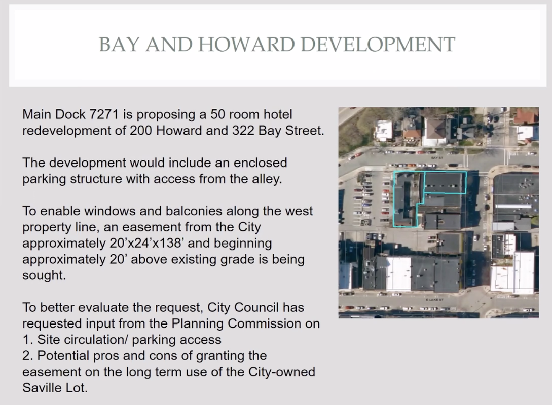
Presented to 21 May 2020 Petoskey City Planning Commission
During the 21 May 2020 meeting, Planning Commissioner Cynthia Linn-Robson referred to the agreement letter farther above referring to the AIR and VIEW easement appraisal between the city and the developer; saying that agreement is too much of a commitment from the city, and giving up too much. Cynthia also suggested that the development could happen in a different way, with the setback on the developer's property. She was also concerned about the open stairway considering Petoskey's winter weather (unrealistic for our winters).
Barry Polzin replied, "This is NOT a view easement. There were some comments made in some of the earlier communications where that was brought up. This is NOT a view easement. We are willing to only take the 20 feet, and so you're right, this [the parking lot area] could be developed as a building. We're not saying you shouldn't do that. Really, the question is, do you want to just leave it parking now or future potential for a building that is a good decision, so unless the decision to have parking is preferred. What we’re asking for is 20 feet to allow us to have openings on the west wall. For someone else to build a building on that lot with the same 3 story 40 foot height you would also have to have that 20 ft space to have openings along that side. So you’re not taking away the opportunity to build a building. You’re not really taking away very much at all. And, one of the exercises that is being done now, or will be soon is the appraisal of this property; and what does the 20 feet take away from that the value of that property, and as we will find out it won’t really take very much away because it’s a part of the property that really doesn’t have very much value. The opportunity to build a building here would be a fantastic location for a building. If the city ever wants to reserve that right it certainly could do that not follow the parking road, but this easement does not… it’s NOT a view easement. So, if a building were built then it’s just tough luck. We’ll have a hotel with nice little balconies and we’ll have a little tiny sliver view. But, we’re willing to accept that. That’s how we’re approaching this. NOT asking for the view."
~~~~~~~~~~~~~~~~~~~~~~~~~
The fact is the easement letter agreement farther above stated, "The air easement would allow the City at some point in the future to construct a 2-story parking platform as long as the parking structure does not interfere with the proposed Air easement." was never discussed during the 21 May 2020 planning meeting.
The same letter farther above called the easement an air AND view easement! A written document is legal... how legal are anyone's often "morphing" WORDS which are not documented in minutes?
Planning commissioners addressed the narrowness of the alley, and City Planner Tweeten stated the alley was 10 feet wide. Concern was stated that the cars (from either the hotel or a city parking structure) from Shoppers Lane would have to exit by going across a sidewalk, and that the traffic would be heavy. It was noted that with a city parking structure below the second floor level, it would have to be partially below grade level. Barry Polzin offered that with the city structure open-air, no ventilator would be required.
Below are the 21 May 2020
Petoskey Planning Commission meeting DRAFT minutes for the same meeting as noted above.
Petoskey Planning Commission meeting DRAFT minutes for the same meeting as noted above.
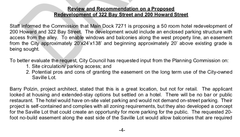
21 May 2020 ~ Petoskey Planning Commission meeting DRAFT minutes continued below...
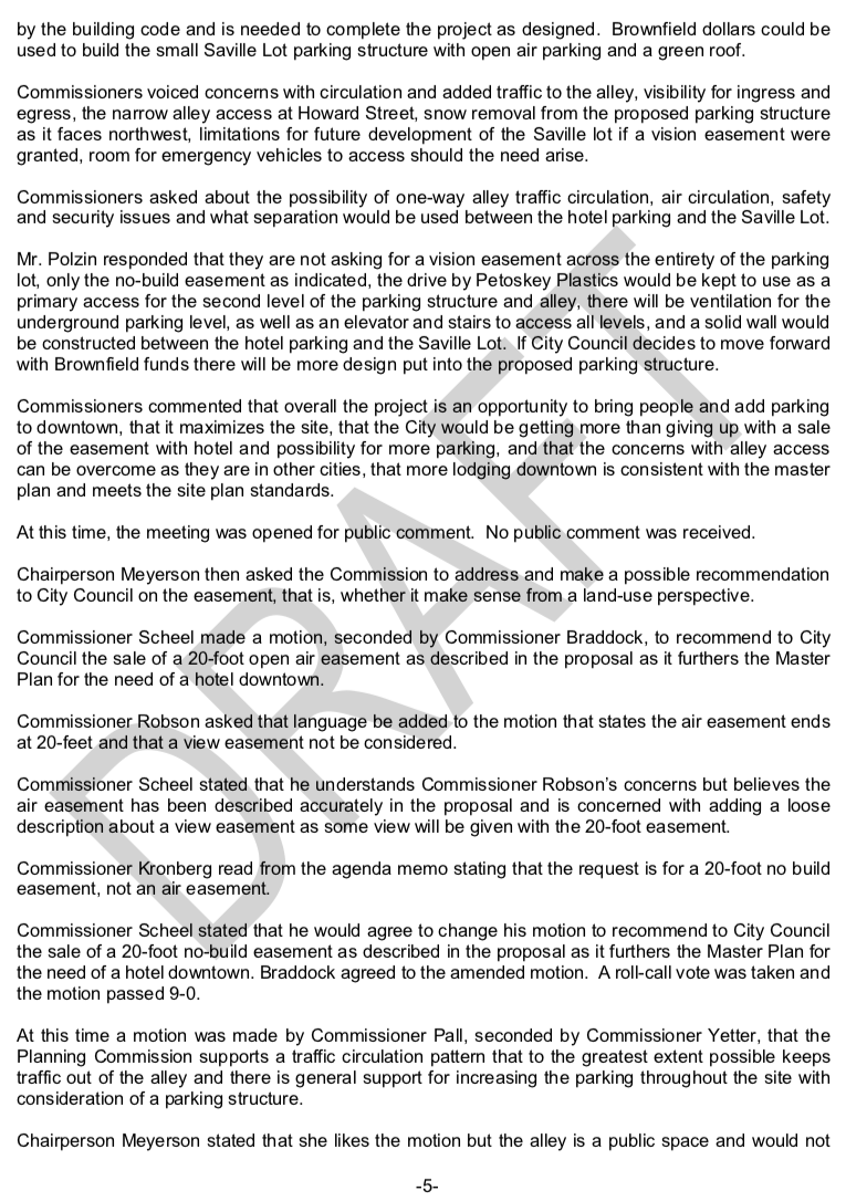
21 May 2020 ~ Petoskey Planning Commission meeting DRAFT minutes continued below...
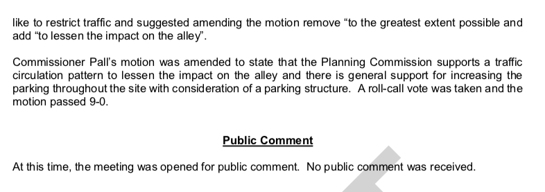
21 May 2020 ~ Petoskey Planning Commission meeting DRAFT minutes continued from above...
The Planning Commission unanimously passed the motion stating: "To recommend to City Council the sale of a 20-foot no-build easement as described in the proposal as it furthers the Master Plan for the need of a hotel downtown."
The Planning Commission unanimously passed the motion stating: "The Planning Commission supports a traffic circulation pattern to lessen the impact on the alley and there is general support for increasing the parking throughout the site with consideration of a parking structure."
On 15 June 2020 the Petoskey City Council will discuss a request
from Bay and Howard Street hotel developers to commence work on an Act 381 Brownfield Work Plan.
Information below is included in the Petoskey City Council packet prepared 11 June 2020 or before,
for the 15 June 2020 City Council meeting.
from Bay and Howard Street hotel developers to commence work on an Act 381 Brownfield Work Plan.
Information below is included in the Petoskey City Council packet prepared 11 June 2020 or before,
for the 15 June 2020 City Council meeting.
Included in the Petoskey City Council packet prepared 11 June 2020 or before,
for the 15 June 2020 City Council meeting continued below...
Included in the Petoskey City Council packet prepared 11 June 2020 or before,
for the 15 June 2020 City Council meeting continued below...

Included in the Petoskey City Council packet prepared 11 June 2020 or before,
for the 15 June 2020 City Council meeting continued below...
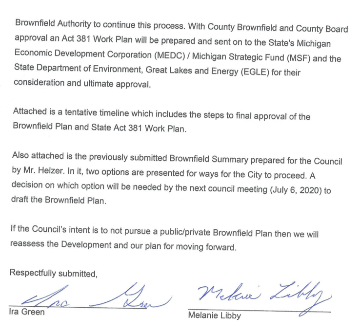
Included in the Petoskey City Council packet prepared 11 June 2020 or before,
for the 15 June 2020 City Council meeting continued below...
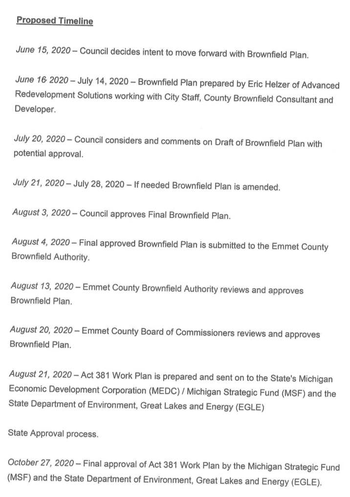
Included in the Petoskey City Council packet prepared 11 June 2020 or before,
for the 15 June 2020 City Council meeting continued below...

Included in the Petoskey City Council packet prepared 11 June 2020 or before,
for the 15 June 2020 City Council meeting continued below...
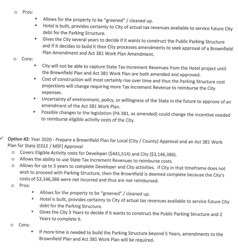
Included in the Petoskey City Council packet prepared 11 June 2020 or before,
for the 15 June 2020 City Council meeting continued from above...
During the 15 June 2020 meeting Council Member Marshall had asked what had happened with "the appraisal" that was supposed to happen a couple of weeks ago. Next, she revealed that the previous Thursday (11 June 2020) the council was informed that the "project" was not happening AND THEN on the next day (12 June 2020) an e-mail was received that the "project" was happening. Ms. Marshall said that Mr. Polzin had stated that without the air easement he would not want to go forward. So, that appraisal question had not been answered [with no appraisal having been performed]. Mr. Polzin was then asked by the city manager to address "the appraisal" and the "$7,000.00 check." Mr. Polzin replied "Basically, the appraisal is underway. There was some misunderstanding whether there was... what the intent of the appraisal what it was for and so it was temporarily held back [the misunderstanding was not explained. LATER: A 22 June 2020 Letter from the appraisal company was addressed to City Mgr. Robert Straebel "submitting the appraisal of the referenced property... for "the air rights/easement""]. The check has been sent. It's in the works now, and as Rob [city manager] mentioned we are looking for that July 6 meeting and that discussion to take place." Mr. Polzin then immediately changed the subject to what he called the "purpose of tonight's meeting and the action that we're looking for is to talk about the Brownfield." ..."The drafting of a Brownfield plan is very involved and very expensive [These are verifiable and reimbursable expenses for the developer]. So the developer is a little bit reluctant to move forward with that unless we actually understand what the council actually intends to do here with it. So, what we’re asking for tonight is what is your intention, your interest, you know if this is like maybe we will, maybe we won’t, then the developer has to decide well, do I want to spend this substantial amount of money to draft a plan if you really are not very set on this, so I guess that is what we are looking for [Sounds a bit like Mr. Berg's ultimatum with Hole #1]. So, if you want to pursue a Brownfield plan, we’re willing to do it, but if you’re not, we’d like you to say so now so we can move forward, reassess the whole situation and move forward with a different plan of doing this project. That’s basically what’s on the table here….” Mr. Polzin continued with... Option two is the preferred option where the city is built into the plan to start with. Option one the city is not written in, but could be added later. “The drafting of the plan needs to start now to get it through all the steps so we can get something started on this project and not delay it out for another year or so. So that’s basically where we’re at.”
Councilman Wagner said he doesn't understand so many different plans, but he likes the most recent plan [could morph at any time, however].
Councilwoman Marshall said she needs to see that air easement appraisal before she goes forward about a Brownfield, and to know what that Brownfield means.
Polzin interjected, "What we're looking for, is what we're proposing to do with parking, something you are strongly interested in. Is the Brownfield to build city parking something you're strongly interested in. This is not a commitment to it [Brownfield]."
Councilwoman Walker added… she was looking at “the process... and the proposed timeline seems a tiny bit disingenuous because work has been done before hand, … and a decision made on the air easement that’s a factor in a number like we still don’t have the information before us."
Councilwoman Shumway said she has listened to the developer's iterations that they know Brownfield is out there, but it is not dependent on it... whether they get the Brownfield, but do it only, then air easement estimate appraisal did not happen with no payment. "The developer is asking if we want to commit to the development, and we could very just as easily ask the developer the same thing. We’re standing on very infirm ground it seems to me and the ground seems to be shifting quite a lot. That makes me a little bit leery in going forward with a Brownfield plan that it might be committing us to something that we do not want to be committed to."
Mr. Polzin told that "the developer doesn’t need for you to build a parking structure next door, so this is really your opportunity to say yes we’d like to move forward with this… The developer could easily just say okay never mind and that’s why we’re asking the question, and... the air issue is two separate issues, neither one depends on the other. Are we wasting our time on developing a brownfield plan, and not to mention, really a lot money [Developing a Brownfield Plan is a verifiable and reimbursable expense for the developer]; so that’s the question. Is there a real interest in the city building a parking deck here?"
Ms. Marshall asked Mr. Polzin, "Have you changed your position that the air easement is no longer necessary to go on with the project?" to which Mr. Polzin replied, "The air easement IS necessary to go forward with the project that we have put on the table. You know there has always been that opportunity you know to do something else, but we don’t know what that is so in order to get this project to work we need that air easement." and again later he said, "to do the 50 rooms we absolutely need the easement." [Still a question of what kind of easement, air and/or view, is being appraised as morphed over the last months].
Mr. Wagner made a motion, but did not receive a second, until the Mayor stepped in to second the motion, and also added, that he liked the parking, and that it is a covered lot [the plan shown to the planning commission did not have totally covered second story, and had an OPEN stairway]. AND, the park setting above is a great addition [no mention that the park would be a considerable additional expense for the city, not included in the proposed Brownfield Plan]. No mention was made of the actual few numbers of parking spaces to be gained by having a second level constructed and a requiring a total of well over $3 million.
The motion made, with Mayor Murphy ad libs was something like: Move forward with Option 2 by sending it for review from the Downtown Management Board to direct the developer to move forward on the Brownfield to gather the numbers with the county. ~ Only Marshall voted no.
ACTUAL MINUTES FOR ABOVE READ as follows:
"City Councilmember Wagner moved that, seconded by Mayor Murphy for 'the developer to commence work on an Act 381 Brownfield Work Plan with option two and direct the developer to present the Brownfield Plan concept to the Downtown Management Board at their next meeting.'" [No mention for the DMB to call a Special Meeting, but a Special DMB Meeting was held.]
Said motion was adopted by the following vote:
AYES: Shumway, Wagner, Walker, Murphy (4) NAYS: Marshall (1)"
[Do the hopeful developers yet own the Petoskey Land and Cattle Company property?]
The DRAFT minutes below for the 15 June 2020 council meeting give a minimal report of what transpired at the meeting, as some of meeting was transcribed above. "...heard from those supportive of plan and option two" was in zoom meeting DRAFT minutes below, for instance, but no examples of the statements regarding the plan or option two. In months or years to come, no written document will state any meaningful explanation of what actually was discussed... just that a discussion was held.

l5 June 2020 Petoskey City Council meeting minutes...
Minutes Above: The motion that had to be seconded by the mayor because no other council members offered to second the motion, directed the developer to present the Brownfield concept to the Downtown Management Board at their next meeting. The DMB, however, evidently, decided to not wait for its next meeting, and called a SPECIAL MEETING (ZOOM) for 30 June 2020 as regarding the below "Agenda" AND "Memorandum" of the Downtown Director (Click to enlarge for easier viewing).
Downtown Management Board "ZOOM" SPECIAL MEETING
30 June 2020
30 June 2020
Downtown Director Becky Goodman sent the following 23 June 2020 Memorandum
to the Downtown Management Board in the agenda packet for this Special Meeting.
to the Downtown Management Board in the agenda packet for this Special Meeting.
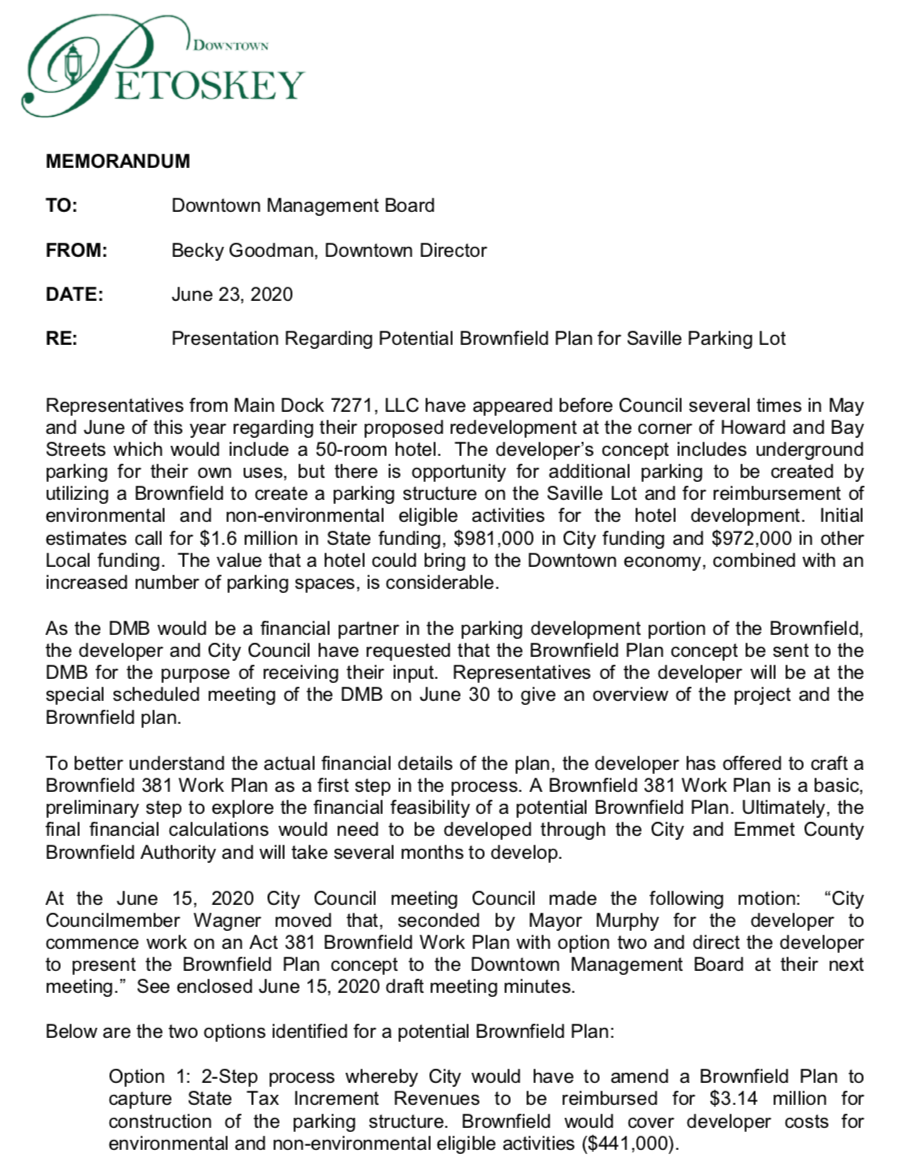
Downtown Director Becky Goodman sent the following 23 June 2020 Memorandum
to the Downtown Management Board in the agenda packet for this Special Meeting... continued column right
|
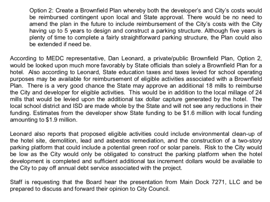
Downtown Director Becky Goodman sent the following 23 June 2020 Memorandum
to the Downtown Management Board in the agenda packet for this Special Meeting... continued from left column
Note: reference to "construction of two-story parking platform that could include a potential green roof or solar panels." No mention that the "two-story parking platform: would forever limit the city being able to use their own property for higher than that AND that a "green roof" or park top would be additional money.
|
"Option 2" noted in the Memorandum above is advantageous to the developer, but not necessarily to the City, in that once the City becomes involved in a Brownfield Plan, the developer holds all of the cards to be played. The developer can immediately proceed with their plans, once the Brownfield Plan is approved by the City, the County, and MEDC, even if the City does not go forward with a parking structure for up to five years, or ever. Once the joint Brownfield Plan is signed, the developer can proceed with razing the present buildings, digging a hole for the basement, and any other changes to the property... AND receive the Brownfield funding for that part of the plan, costing the developer nothing for that preliminary work! With nothing to lose, no investment, the developer can ask the City for a project height variance, or any other ordinance variances; and if the City says no, then the developer can leave the City with a SECOND HOLE, because the developer already will have received their part of the Brownfield funds to have the present buildings razed, a hole dug, for the basement, and any other changes they will have made to the property. The City will have been sucked into the SECOND HOLE with the sign-on of the joint Brownfield Plan.
IF the City agrees to this Option 2 to go ahead for the Brownfield Plan with a parking structure, has the City locked itself into only a two-level parking structure on its own property in the future as referenced in several verbal and written items?
IF the City agrees to this Option 2 to go ahead for the Brownfield Plan with a parking structure, has the City locked itself into only a two-level parking structure on its own property in the future as referenced in several verbal and written items?
It was interesting that during this 30 June 2020 DMB zoom meeting that no Board Member expressed a concept of just how many millions of dollars Polzin said the city will need to front for a basic parking structure, with no admitted concept of how the proposed Brownfield would work time-wise, or how much money a Brownfield would siphon from the schools, or even from the city, for years to come... not to mention money to be committed from the DMB's parking funds. Nor was any realization expressed that the possible park on the rooftop is definitely an added expense. Do these board members realize that the city must FRONT the parking structure money, and would be repaid for verifiable expenses over a period of years, not in one lump sum? Bonding would have to go forward before the city project was built. This board did not appear to realize that the upper level parking deck does not have a roof over the ENTIRE parking area for wintertime protection from the elements. The architect promoted the partial roof as being open air to eliminate, as he stated, the "tremendous cost of a ventilation system." Also, while excessive alley traffic was discussed, no one mentioned that the upper parking level, having only alleyway ingress/egress, supposedly will add 48 spaces so, thus 48 potential vehicles in the alley (double that really because the cars would leave also, PLUS the hotel has the potential of 50 rooms and thus, 50 vehicles (100 with ingress/egress) which will go up the alley whether driven by a valet parking jockey, or not, PLUS Polzin stated about 25 employees also will need to park… anyway, that has the potential of adding about 200+ vehicles to the present alley traffic which includes delivery and utility vehicles… PLUS a question was asked about the Lake Street store owners who do park behind their stores, or some of the Lake Street stores have patron parking spots on their own property. Any alley traffic issues seemed to be pooh-poohed, and put off with the possible need for a traffic STUDY (promoted by the mayor and the city manager). Board member Waldie-Bennett questioned who would be responsible for paying for the studies and different concept of the parking structure. The Architect said that the cost of designing the parking structure are eventually paid for through the TIF, although the city will have to FRONT the money. [LATER: in the 6 July 2020 City Council meeting this was NOT to be a traffic STUDY, but rather a look at "Traffic Circulation," using Walker Consultants, which could take just 2 or 3 weeks.] Also, Murphy is trying to push the idea of a “performance bond” to the side, by saying that the hotel will be built before the parking lot. Well, maybe not, if the developers decide to go ahead with razing the old buildings, and digging the foundation HOLE… just like, as someone mentioned, 200 East Last Street progressed. The Bay Street HOLE could be left until the city might agree to whatever additional variances the developer might wish to pursue. Nor, did anyone pick up on the fact that the city will only be allowed to build a two-story structure in the future to adhere to agreements in an AIR Easement (different from a no-build easement).
Finally, Mr. Harris made the motion that the DMB was "interested in supporting the concept, or some similar concept, and see the developer move forward with it." No inclusion in the motion of an amount of monetary support that the DMB would commit to the city's involvement with a possible parking structure... just general "support." All was quite vague, but the motion passed unanimously.
Finally, Mr. Harris made the motion that the DMB was "interested in supporting the concept, or some similar concept, and see the developer move forward with it." No inclusion in the motion of an amount of monetary support that the DMB would commit to the city's involvement with a possible parking structure... just general "support." All was quite vague, but the motion passed unanimously.
The minutes for the 6 July 2020 City Council Meeting City Manager Update stated about the above DMB meeting: "The DMB discussed a Brownfield Plan for a proposed hotel and to fund a parking structure at the Saville Lot and consensus of board members (7-0) was the DMB is 'interested in supporting the concept or some similar concept and suggests developer move forward with it.'" AND "The Emmet County Brownfield Redevelopment Authority (ECBRA) requested initial information and a summary presentation regarding the proposed Brownfield Plan for the hotel and Saville Lot parking structure." AND "City Council will discuss the Action 381 Brownfield Plan on July 20 and possibly August 3."
THEN, "City Councilmembers inquired if the DMB actually voted on something for the potential hotel development and if there was any additional information or redevelopment plans for the Michigan Maple Block property.
The City Manager responded that there was a motion and support by a 7-0 vote that the DMB showed interest in supporting the concept or some similar concept and suggested developer move forward with it." [Whatever that meant...]
Agenda Memo Including the Air Easement Appraisal for Discussion
Prepared 1 July 2020 for 6 July 2020 Petoskey City Council Meeting
(MORE MORPHING ~ 04/28/20 Architect Plan names "20' NO BUILD easement".
2 June 2020 Appraisal names "AIR easement")
Value of Air Rights Dated for 2 June 2020
Prepared 1 July 2020 for 6 July 2020 Petoskey City Council Meeting
(MORE MORPHING ~ 04/28/20 Architect Plan names "20' NO BUILD easement".
2 June 2020 Appraisal names "AIR easement")
Value of Air Rights Dated for 2 June 2020
AIR EASEMENT
(FOR LIGHT, AIR, ACCESS & FIRE SEPARATION OVER & ABOVE)
(FOR LIGHT, AIR, ACCESS & FIRE SEPARATION OVER & ABOVE)
The value of the 5,520 square foot air easement is calculated at $57,000.00 using the sales comparison approach. 'The air rights easement above the Saville Lot is rectangular in shape with dimensions of 20’ wide, 21’ 4” tall and 138’ long. See page 4 of the appraisal "General Information" for a visual depiction of the proposed air easement.
Pages 3 and 4 of the appraisal "General Information" notes: "The proposed easement states that, 'No structure, landscaping or other feature shall be built, installed or otherwise permitted to be placed within the Easement that exceeds a height above elevation 645.93 (1988 NGV Datum). The Easement is for the purpose of providing an easement for light, air, access and fire separation distance over and above the described portion of Parcel 1 for the benefit of Parcel 2, and no structures or landscaping shall be permitted in the Easement area. The parking lot easement possesses a value for the 'Air Rights'. Air Rights are defined as 'the right to undisturbed use and control of designated air space above a specific land area within stated elevations.'"
[Undisturbed use and control of an air space" includes the sunlight and shadows that may fall on the easement area... SO, no building on the city parking lot that might cast a shadow, or shade the sunlight which would only allow a two-story parking, (or any other kind of) structure, even though the city would have a legal right to build a three story structure (plus a basement) just like the developer's hotel plans. But, NO, the city may never build a structure on a prime piece of real estate with a view of the bay that encompasses the present Saville Lot.]
Page 4 of the appraisal "General Information" notes: "Air rights may be acquired to construct a building above the land or to protect the light and air of an existing or proposed structure on an adjoining lot. Air rights do not always include development rights. The terms air rights and air space often are used interchangeably. Air rights refer to the leasehold interest or right of use of property above ground level."
Page 19 of the appraisal "Property Analysis" notes: "Land Description-Parent Site Primary Street Frontage as "Bay Street - 50 feet." [What happened to the 20 feet width?]
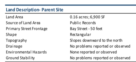
Page 19 of the appraisal "Property Analysis"
TOP
PARKING SPACES & VALUE
Below Agenda Memo provided by city staff for the City Council 6 July 2020 meeting: Note that for all of the effort, and time, and over-an-estimated $3,000,000.00 in taxpayer funding, in the end, the city will acquire THIRTY-NINE parking spaces! Keep the present number of 45 parking spaces on the Saville Lot in mind, as well, as you read through the appraisal rationale. Numbers count!!

From the Agenda Memo prepared 1 July 2020 for the 6 July 2020 City of Petoskey Council meeting
On page 15 of the "Area Analysis" of the appraisal, shown below,
it states that the Saville Lot consists of 65 spaces with a value of $569.00 per space!
That's one level presently!
it states that the Saville Lot consists of 65 spaces with a value of $569.00 per space!
That's one level presently!
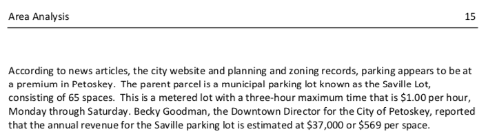
Page 15 of the "Area Analysis" of the appraisal stated ground level indluded 65 spaces
[The written "65 spaces" must not be a typo, in the appraiser's eye, because
the same "65 spaces" was restated on page 26 (below) of the appraisal.]
the same "65 spaces" was restated on page 26 (below) of the appraisal.]
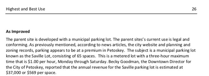
[The architectural plan dated 28 April 2020 stated the ground level included 36 spaces as shown below, rather than the staff's present 45 parking spaces, OR the appraiser's 65 spaces (stated above) for the same "parent parcel" reported revenue for the city officials to consider per space. If Becky Goodman's reported annual income for the Saville lot is correct at $37,000 for the city officials to consider, per the architects noted 36 spaces; then presently, that computes to $1027 per space (rather than to $569 per space)... a much more valuable land value per space.]
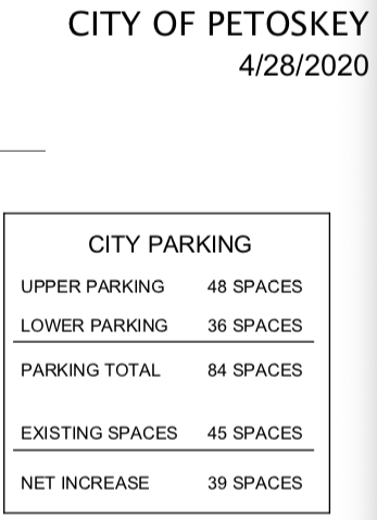
The architectural plan for 28 April 2020 stated the ground level included 36 spaces
Page 15 of the appraisal "Area Analysis" below notes: "It is unlikely that any city owned parking lot would be sold for re-development into an additional commercial building, due to the current lack of parking."
[At a previous meeting a county elected official did pose the possibility of the city building two floors of parking with a residential floor, or office spaces, at the top to enjoy the views.]
[At a previous meeting a county elected official did pose the possibility of the city building two floors of parking with a residential floor, or office spaces, at the top to enjoy the views.]
Page 15 of the "Area Analysis" of the appraisal
The appraisal analysis of the "Hole" or "Pit", as reported below still on page 15 of the appraisal, shows either a bias favoring any developer, or else slanted information having been promoted to the appraiser, thus generating the derogatory last sentence: "The current owner [Mr. Berg] has presented several plans for redevelopment, but has not received any approvals due to ongoing issues with some commissioners."
[Perhaps it should have been considered, and reported in the appraisal, that the developer had the ongoing issue, rather than some commissioners... AND, is this referring to city councilmembers OR city planning commissioners, OR county commissioners?]
[Perhaps it should have been considered, and reported in the appraisal, that the developer had the ongoing issue, rather than some commissioners... AND, is this referring to city councilmembers OR city planning commissioners, OR county commissioners?]

Page 15 of the "Area Analysis" of the appraisal
Page 36 of the appraisal "Sales Comparison Approach" notes: "Further, the intended use of the easement/air right space is to remain vacant (undeveloped) so as to allow ingress/egress, fire safety access and natural light preservation. As previously mentioned, it is unlikely that the City would sell the site for redevelopment due to the need for the parking lot that serves the surrounding business. While it is possible that a multi‐story parking garage could be built, it is unlikely due to the high cost..."
[The reiteration above, by the appraiser, of the easement space to allow "access and natural light preservation" should be heeded. This is more than a "no build" easement just within the 20 feet horizontal space. Light preservation has to do with sunshine and shadows which could be cast, or hindered, if the city built a three story structure on the city property, for instance. Also, the mention here of the City not pursuing a parking structure "due to the high cost" does not elaborate on fact. Even if the City agreed with the air easement, and its own parking structure, under the guise of Brownfield funding, the City must fund the money up front, and then the city would be paid back over a number of years through taxes and the Brownfield Authority for allowable and verifiable expenses. The high cost for an additional 39 parking spaces is not going to change, just by going for Brownfield Funding.]
GENERAL INFORMATION
Page 9 of the appraisal "Area Analysis" notes: "The subject property is located within the City of Petoskey, approximately 1.5 blocks east of the Federal U.S. 131 highway (Spring Street), an arterial north/south thoroughfare. The immediate neighborhood is within the City of Petoskey downtown central business district."
[The northern terminus of U.S. 131 is the corner of Spring Street and Charlevoix Avenue NOT 1.5 blocks from the subject property Saville Lot.]
Page 10 of the appraisal "Area Analysis" notes: "The population within the city limits of Petoskey for the year 2010 was 5,670 persons and has decreased to 5,756."
[How is going from 5,670 to 5,756, a decrease? On page 16 of the "Area Analysis" the Demographics stated Petoskey's population went from 2010's 5670 to 2020's 5636, which does show a decrease.]
Page 25 of the appraisal "Highest and Best Use" below both Financially and Maximally Productive notes:
A mixed use of commercial and residential use is best for the parent parcel.
A mixed use of commercial and residential use is best for the parent parcel.
[What an interesting conclusion when remembering that the proposed hotel site was first presented as Mixed Residential and Commercial which grabbed everyone's attention. With that conclusion for the city's property, the city should not sign away that very option in the form of an easement for an appraisal of a mere $57,000.00.]
Page 26 of the appraisal "As Improved Use" notes: "Based on our analysis, the current as improved highest and best use of the parent site is for continued use as a parking lot."
[Hmmmm. That fits right into the developer's plans, but what are the city's future plans for the parcel? IF the city signs the air easement agreement, only one future plan will possibly exist... a two-story parking structure adding 39 spaces. Just forget that the same appraisal just stated on page 25 that the best use for the property would be a mixed use of commercial and residential.]
Page 26 of the appraisal "Most Probable Buyer" notes: "...the likely buyer is a local investor that would continue to operate the parent site for parking, until a or several [sic] multi‐story parking garages are constructed to satisfy the demand for parking."
[Why is consideration not given also to the City NOT SELLING the site, and the value in that respect? Is the air easement appraised on its value to the city, or its value to the hotel developer? The situation on this parcel, is that if the air easement is approved for sale to the developer, the city's entire Saville Lot property is affected (restricted) for any future development by the city.]
SALES COMPARISON APPROACH
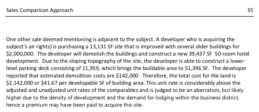
Page 35 of the "Sales Comparison Approach" of the appraisal
According to the Emmet County Property Search web site on 4 July 2020, the two proposed hotel site properties are not in the developer's name, with any actual sale price recorded. IF the Brownfield Plan is approved, demolition is a reimbursable expense and not a cost. One has to wonder IF the developer will actually pay $2,000,000 as stated above because the properties were both listed for purchase by the current property holder, with the most recent "Sale Date" of 16 December 2016... 200 Howard Street sold for $445,765.00 and 322 Bay Street sold for $367,574.00. with the total of the two properties thus equaling $813,339.00; not even one million dollars. So, if the new Main Dock developers are willing to pay TWO million dollars for the two Howard and Bay street properties, that is giving the present property owner a profit of over a million dollars in about 3 and a half years!!! Business acuity is lacking somewhere in this stated property deal. AND, by an appraiser using these figures for property value, it is very well the city is being bamboozled in some way.
Page 36 of the appraisal "Sale Comparison Approach" notes: The appraiser's "Land Value Conclusion" below, for the value of the city's Saville Lot is $269,100.00. Farther above on the same page 36 the appraiser wrote: "In order to derive our opinion of the value for the permanent easement, we applied our opinion of the parent across‐the‐fence land value of $13/SF to the area of the permanent easement area of 5,520 SF. Based on this calculation, the value of the permanent easement, prior to applying a discount, is ($13/SF x 5,520 SF) $71,760." [It seems an "ACROSS-THE-FENCE" comparison could not be much closer, across the fence, to the city Saville Lot than the developer's statement of "purchase price" of $2,000,000.00 for the cost of the hotel property! Such a disparity in lot value cannot be explained away, other than perhaps some type of bias in the "Land Value Conclusion"? The Saville Lot has a much better view, and no buildings need even to be razed. Which would be the better deal for a developer, or any land purchaser? The Saville lot for $269.100.00 OR the Howard and Bay Street properties for $2,000,000.00?]

Page 36 of the appraisal "Sale Comparison Approach"
Regarding below Agenda Memo prepared 1 July 2020 for the 6 July 2020 City Council Meeting... A 20% discount seems unnecessary because the city should still be considering exactly what should be done with the entire piece of Saville Lot property... not assuming that a level of the property would not be developed. That is an inaccurate assumption to reduce the appraisal amount value. The appraiser considered square footage for the hotel development having 4 levels with lower level parking due to topography, but does not consider the same for the sloping Saville Lot which also could have a lower level for parking.
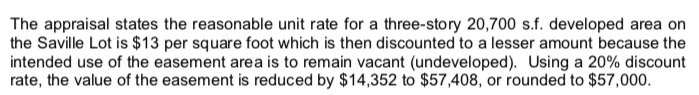
Agenda Memo prepared 1 July 2020 for the 6 July 2020 City Council Meeting
Agenda Memo prepared 1 July 2020 for the 6 July 2020 City Council Meeting
Regarding above Agenda Memo prepared 1 July 2020 for the 6 July 2020 City Council Meeting... 1) Asking for city council action regarding the "AIR Easement" would mean that AIR easement MUST be defined specifically since the type of easement has MORPHED so many times since the inception of this Bay/Howard Project. 2) If the city begins preparing for "a clear, demonstrable connection of how both structures interrelate to each other" the city may as well sign over its own parking Saville Lot to the developer... getting closer to getting sucked into HOLE #2!
6 July 2020 City Council Meeting
After Discussion, Council Member Walker asked Clerk Terry to "articulate" her motion, to which he replied: "Motion made by Walker, seconded by Wagner, of the affirmation of acceptance of the appraisal or concept of granting the agreement." The Motion Passed 4-1.
Architect Polzin, representing the developers, responded during the meeting, before the above motion was made: "Agree with appraisal and agree with the price, so certainly no problem with that at all. I guess, but, really what we thought we’d be talking about tonight, and we have been looking for tonight, and what we are looking for tonight is a commitment that you are indeed willing to sell this as an easement and that you accept the appraisal. Look I know we have been taking baby steps on all this. Well, we need that affirmation that you are willing to do this. Because every time, every week, there’s 10 of thousands of dollars that have to be spent to keep this process moving and the developer frankly is extremely nervous that you’re just going to string this out forever and the developer will walk away from it because they don’t have the stomach for it. So, that being said, it seems it’s a pretty simple small step to say yes, we’re willing, and guess to look at and answer Pete’s [who is Pete?] question why to do this. The city benefits from this. The hotel is the great asset for downtown. It brings people. It brings dollars. We’re providing our own parking, so it’s a great asset. It’s also a $3 million gift to the city if you choose to accept it. So, so far, we’ve taken this to everybody and we’ve gotten unanimous 100% support for this project from all the other entities so we just want to keep the project moving forward and we want some affirmation from you tonight. The traffic study… it’s a great idea. We’ll look at that. This came up at the planning commission. It really has very little to do with this easement of question. The easement is up in the air. It does not affect anything on the ground where all the traffic’s going on. The traffic study will inform the final design of our project, the hotel, as well as the city parking structure. So, I don’t see this as holding up the agreement. Certainly there are terms to write into this purchase agreement such as the development aspect. Yes, if the hotel does not move forward this easement is not granted. But, however, we will need the easement in place to get a building permit. So, just keep that in mind; but, all those things we can work through in the next few weeks in terms of the actual agreement and tonight we just want a commitment that Yes, we’re willing to sell this. Let’s move forward."
6 July 2020 Minutes for the City Council Meeting
206 Howard Street in 1947
13 November 1947 ~ Northern Michigan Review
Below: This Packet Memo for ECBRA preparation for 9 July 2020 Meeting was also included for the Emmet County Board of Commissions 23 July 2020 Meeting. This is the very FIRST statement that Main Dock 7271 LLC is "proposing to acquire” 206 Howard Street and 312 Bay Street. So far, public records do not show that Main Dock owns ANY of the properties.
This is another Gigantic Morph with these two 206 Howard Street and 312 Bay Street addresses of properties that Main Dock plans to acquire (along with previously told 200 Howard Street and 322 Bay Street)! Since both the ECBRA consultant McClelland and the developer's BRA consultant Eric Helzer (both paid for through "reimbursible expenses" for performing much the same tasks), who actually contributed to this particular MORPH of involved properties? 206 Howard Street belongs to an entirely different LLC, AND 312 Bay Street belongs to the City of Petoskey (a portion of the Saville Lot)? Either Helzer, or McClelland, or BOTH have presented this information! So have plans been made behind-the-scenes for the city to sell their parcel at 312 Bay Street, putting the City closer to the edge of being sucked into a Second Hole? OR is it just a permissible "standard operating procedure" to just present whatever in a Brownfield Plan when it is a "concept"??? It must be perfectly acceptable when the NUMBERS OF MORPHS just for this one development/parking structure plans are considered. It seems that various involved governmental entities; whether the city council, the city planning committee, the city's DMB, the ECBRA, or the ECBOCs have each had various CONCEPTS to consider... the same concept, perhaps in name only, although now, even the properties involved have changed. Each entity is making a decision from a different "concept plan".
This is another Gigantic Morph with these two 206 Howard Street and 312 Bay Street addresses of properties that Main Dock plans to acquire (along with previously told 200 Howard Street and 322 Bay Street)! Since both the ECBRA consultant McClelland and the developer's BRA consultant Eric Helzer (both paid for through "reimbursible expenses" for performing much the same tasks), who actually contributed to this particular MORPH of involved properties? 206 Howard Street belongs to an entirely different LLC, AND 312 Bay Street belongs to the City of Petoskey (a portion of the Saville Lot)? Either Helzer, or McClelland, or BOTH have presented this information! So have plans been made behind-the-scenes for the city to sell their parcel at 312 Bay Street, putting the City closer to the edge of being sucked into a Second Hole? OR is it just a permissible "standard operating procedure" to just present whatever in a Brownfield Plan when it is a "concept"??? It must be perfectly acceptable when the NUMBERS OF MORPHS just for this one development/parking structure plans are considered. It seems that various involved governmental entities; whether the city council, the city planning committee, the city's DMB, the ECBRA, or the ECBOCs have each had various CONCEPTS to consider... the same concept, perhaps in name only, although now, even the properties involved have changed. Each entity is making a decision from a different "concept plan".
Packet Memo for ECBRA preparation for 9 July 2020 Meeting
Below: Summary from meeting minutes for...
9 July 2020 Emmet County Brownfield Redevelopment Authority (ECBRA) Meeting
9 July 2020 Emmet County Brownfield Redevelopment Authority (ECBRA) Meeting
Three days after the 6 July 2020 City Council Meeting, the ECBRA Zoom Meeting minutes reported they were hearing the ECBRA's (highly paid) consultant Mac McClelland introduce the "Bay Street Development Project" with Main Dock 7271 "proposing to acquire FOUR parcels at Bay and Howard Street." Now, that was a revelation that no other governmental entity had heard at an open public meeting.... (FOUR parcels? always TWO parcels in the past) and asking the BRA to review the project and the City Parking Facility, to invite a Brownfield Plan for review and consideration in August. The minutes for this BRA meeting reported that Architect Barry Polzin said "they have worked with Mac to create the documents provided today." That leads one to wonder why BOTH Eric Helzer AND Mac McClelland need to prepare a Brownfield Plan... unless it is understood that BOTH ultimately will be reimbursed by taxpayers, because BOTH consultants' fees will be submitted and then will be considered "eligible expenses!"
Polzin said that "Environmental assessments are underway and given the historical uses of the property, contamination from underground storage tanks, auto repair and historical fill is anticipated. The schedule may shift based on the environmental assessments. Parallel discussions are underway with the State of Michigan for State tax capture approval to expedite the process. Site work is anticipated in Fall 2020."
"Rob Straebel, City of Petoskey, thanked the BRA. The City Council is initially supportive, but would like to see the details. The Brownfield Plan will be provided to the City Council at a future meeting. They do not have a formal commitment. The DMB unanimously supported the concept. There is economic synergy with a covered parking, providing for the 2nd and 3rd floors of nearby downtown buildings to be renovated."
BRA member "Smith asked if the funding would be available. Helzer stated that it is strictly TIF, so the revenue would be guaranteed. He anticipates the reimbursement could occur within three years of the private investment. The annual revenue projections can be provided. The total estimated investment is $10 million for the hotel."
"McClelland added that if appropriate, the process would be for the BRA to invite a Brownfield Plan. There are some upfront fees, $3,000 has already been submitted toward review by the ECBRA consultant. It should provide the funding for initial review. If the Board is ready, it may be appropriate to invite a Brownfield Plan."
"Thomassey motioned to invite a Brownfield Plan for the Bay Street Hotel Redevelopment and authorize staff and the ECBRA Consultant to coordinate with the City and development team to review and present a Brownfield Plan and Development and Reimbursement Agreement, subject to subsequent final approval of the Brownfield Plan by the ECBRA and Emmet County Commission and concurrence by the Petoskey City Council, and approval of a Development and Reimbursement Agreement between the ECBRA, the City, and Main Dock 7271 LLC, Smith seconded. The motion passed by unanimous voice vote."
"McClelland stated that he would be working with the developer to finalize the information for the City and then the Brownfield Authority."
Rob Straebel's city manager UPDATE included in the minutes for the 20 July 2020 Petoskey City Council meeting included: "The City Manager reported that the Emmet County Brownfield Redevelopment Authority voted unanimously in favor of moving forward with Brownfield Plan process for the Bay Street hotel redevelopment and that a final draft Brownfield 381 Action Plan will be formally introduced at the August 3 Council meeting.
23 July 2020 Emmet County Board of Commissioners (ECBOC) Committee of the Whole Meeting
As recommended below, the ECBOC approved the motion to set a Public Hearing on 20 August 2020.
On 28 July 2020 it was told that the Public Hearing had been canceled.
On 28 July 2020 it was told that the Public Hearing had been canceled.

Packet Information from ECBRA for ECBOC 23 July 2020 Meeting
Two Items Below were in the ECBOC packet showing these mapped areas as part of the
"Eligible Property Boundaries" for the Bay Street Development Plan dated July 2020.
"Eligible Property Boundaries" for the Bay Street Development Plan dated July 2020.
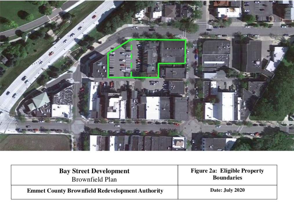
Packet Information from ECBRA for ECBOC 23 July 2020 Meeting
Above and Below Items: The green outlines are not accurate. The dashed green line is cutting off a large portion of the city’s property AND property 226-042 has not previously been a part of the presented Brownfield Plan???? This was what the BRA and the ECBOC, was presented to make their decisions. Just sad for governmental entities to be making decisions that affect so many, based on inadequate, or false information... making decisions with HALF-facts or incorrect facts; not even the same plans being considered by each entity.
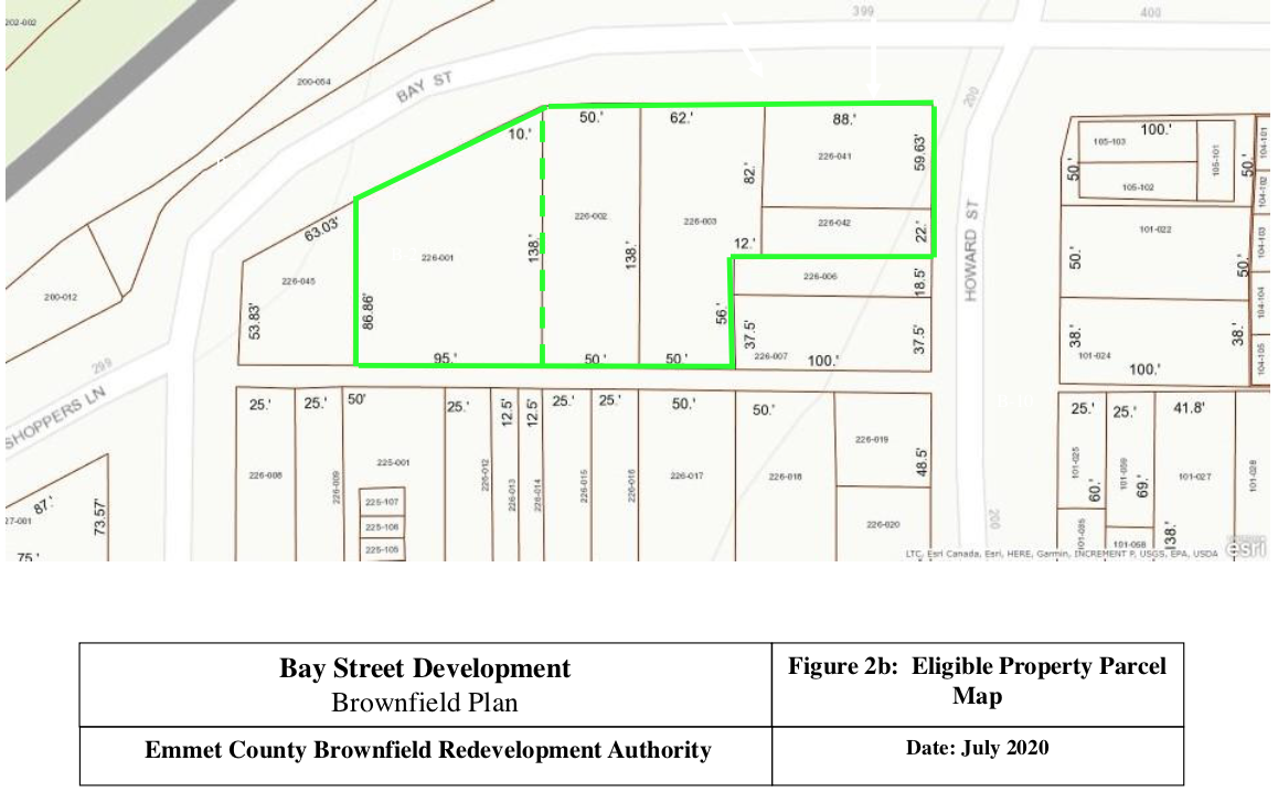
Packet Information from ECBRA for ECBOC 23 July 2020 Meeting
The drawing below was presented to the ECBRA when Polzin explained according to the 9 July 2020 minutes: "Parking would be accessed from the alley or Bay Street with a lift to the second level. Street scape concepts were shown. The public parking would be accessed from Bay Street and would likely be a two-story parking deck. The hotel is a 3-story building. There is a ramp near Petoskey Plastics to access the alley. Because of the slope of the property, parking deck can be accessed on the lower level from Rose Street to the north and on the upper level from Bay Street to the south without the need for internal level circulation. The Planning Commission and Downtown Development Board has 100% concurred that the Saville Lot should remain parking." AND "Pollion asked for clarification about the parking. Polzin stated that the idea is that all guest parking is done via valet."
However, the parking drawing below was what was presented... at least this was what was passed on from the ECBRA to the ECBOC. This plan shows entry to the hotel lower level parking through the Bay Street parking entry way... the upper level did not include a car lift on this same dated drawing for the upper level. The city yet, has NOT submitted any of its own plans for a parking structure, so the figures given for a parking structure within the Brownfield Plan are from Main Dock. Consider what happens in the future IF the city decides to build a parking structure that is not OPEN AIR like any of the Main Dock multiple proposed parking plans; maybe the city will want a parking structure which could actually support a third floor of housing or businesses? That extra support would cost a few million more. Also, even if the city does not build the third floor, talk has been that maybe a public space would be placed on the top of the second parking deck level AT ADDITIONAL COST, of course, from what is proposed in the Brownfield Plan as proposed. A future Brownfield Plan certainly can be amended for city concerns, but the City must have its own actual plans, to actually acknowledge how much stress could be put on taxpayers to purchase bonds... the difference of a few million dollars from an Open Air structure to a structure strong enough to support a possible future third floor would be important in decision making. With the developer's Brownfield planned cost for the city to have about $3,146,000.00 into an Open Air structure with no third level, it still must be remembered that the city would gain only about 39 parking spaces... a pretty heft price.
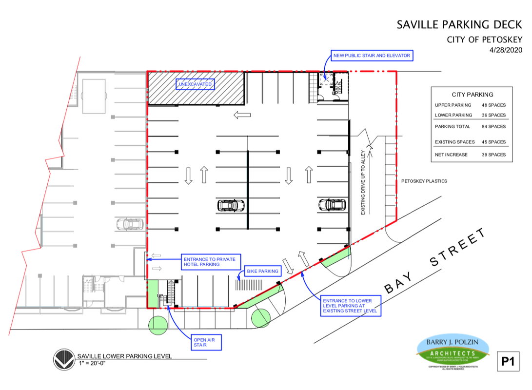
The ECBOC did approve the motion to set a Public Hearing on 20 August 2020.
Packet Information from ECBRA for ECBOC 23 July 2020 Meeting
On 28 July 2020 it was told that the above noted Public Hearing had been canceled.
During the City Manager's Report for the Petoskey City Council's 3 August 2020 meeting, Mr. Strabel stated next meeting may be first city council meeting in September which is mid to late September. Maybe developers would start construction in Spring of 2021.
3 August 2020 ~ City Council Meeting
The DRAFT minutes for the above City Manager's Report stated the following:
Hear City Manager Updates:
"The City Manager reported that the developers of the Bay and Howard street hotel development delayed the introduction of the Brownfield 381 Action Plan and project managers need an additional 30 days or so to finalize cost estimates for the draft Action Plan;"
Hear City Manager Updates:
"The City Manager reported that the developers of the Bay and Howard street hotel development delayed the introduction of the Brownfield 381 Action Plan and project managers need an additional 30 days or so to finalize cost estimates for the draft Action Plan;"
Consideration of this postponing of the Bay/Howard Development makes for wondering. IF PERHAPS, adequate funding is not available without the time restraints presented for seeking the funding of a Brownfield plan, then this entire scenario becomes very reminiscent of the ORIGINAL HOLE when the funding dried up.
The agenda for the Emmet County Board of Commissioners' 10 August 2020 Meeting announced:
"The Public Hearing on August 20, 2020 at 5:45 for the Brownfield Redevelopment Authority Resolution has been cancelled by the applicant."
"The Public Hearing on August 20, 2020 at 5:45 for the Brownfield Redevelopment Authority Resolution has been cancelled by the applicant."
Report included in the Petoskey City Council meeting of 21 September 2020...
21 September 2020 ~ Petoskey City Council Report
The 3 October 2020 Petoskey News Review reported that on 5 October 2020 the Petoskey City Council's Petoskey Capital Improvement Plan will be proposed. In the plan for 2021 "The city will also devote about $300,000.00 for an engineering plan for a parking structure at the Saville lot, which is located on Bay Steet, west of Howard Street."
2021 January City Council Manager's Report
8 April 2021 ~ Emmet County Brownfield Redevelopment Authority meeting minutes
Melanie Libby, along with Iva Green, are the development team of Main Dock 7271 who proposed the boutique hotel on the corner of Howard and Bay streets in 2020
The 5 January 2022 Petoskey News Review reported that the recent owner of Mackinac Island’s Grand Hotel now has bought three more Mackinac hotels. Melanie Libby, who sold these latest properties (The Bicycle Street Inn, Waterfront Collection North, and Waterfront Collection South, as well as Winchester’s Whiskey and Bourbon Room and its liquor license) will remain the general manager of the boutique hotels. The sale also included housing on the island and in St. Ignace for seasonal workers. Libby states she will just be part of a bigger family now, and her past guests should not have any concerns.
“As a child who grew up about an hour east of Gaylord, Libby earned her bachelor’s degree from the University of Michigan and an MBA from the University of Iowa, developing an expertise in finance and logistics that landed her at Ford Motor Co. in the parts and service division.
“I am a numbers geek,” she said. “But I grew up in a family business and I’ve always been bitten by the bug of pleasing people and delighting guests. If that’s in your blood, you just never get away from it, no matter what you do.”
As of 17 January 2022, the county’s GIS plat map shows that Petoskey Land & Cattle Co LLC still owns both 52-19-06-226-041 AND 52-19-06-226-003 which were parts of Green and Libby’s development plan for the corner of Howard and Bay streets in Petoskey, at one time presenting information as if they owned it.
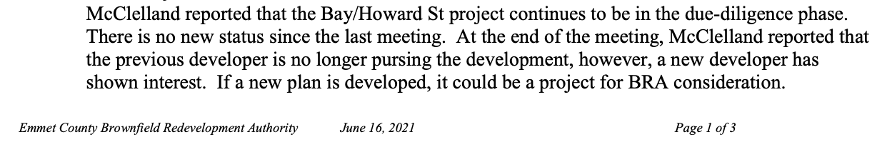
16 June 2021 ~ Emmet County Brownfield Redevelopment Authority meeting minutes
