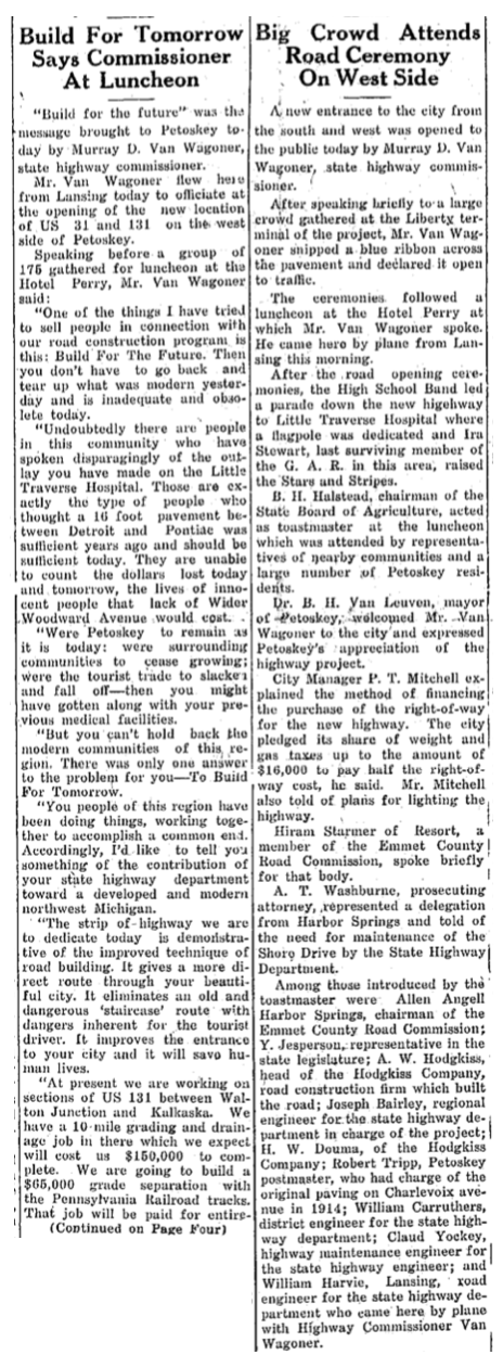
Northern Mich~Mash Preserve
~MITCHELL STREET WAS A DEAD END~
The design and compilation of the text and photos on this site are copyrighted 2017.
Most posted items will enlarge by "clicking" on them.
"Clicking" on some color highlighted words may access additional information.
Most posted items will enlarge by "clicking" on them.
"Clicking" on some color highlighted words may access additional information.
Please do not copy the photos on this site, many of which have been submitted by private individuals...
just come back and visit the site often to view the photos.
just come back and visit the site often to view the photos.
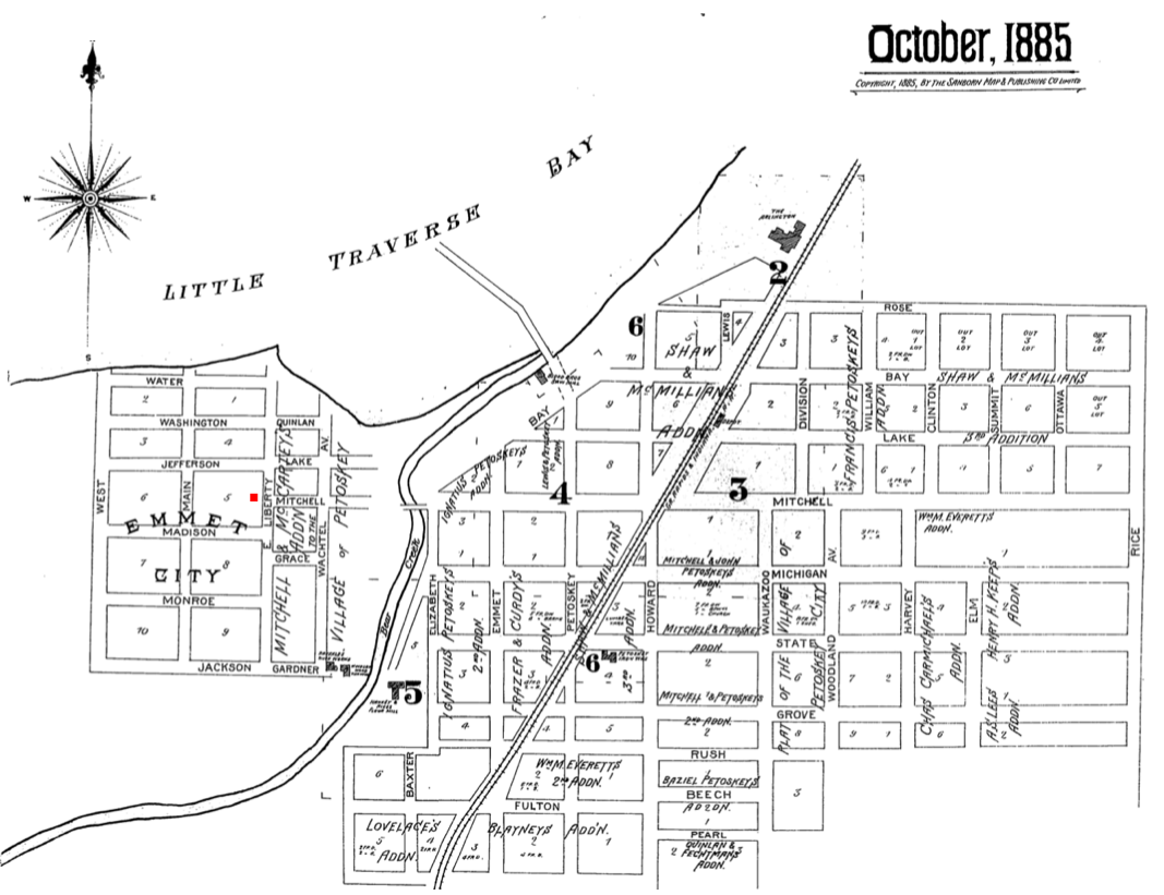
1880 Map Below (Click to enlarge) :
In 1880 Mitchell Street dead ended on the east side of the Bear River...
no bridge existed to reach the west side of the river from Mitchell Street;
first a log, then a wood bridge, and next a steel structured bridge.
Finally, even after the still existing 1931 constructed concrete bridge extended over the Bear River...
West Mitchell Street continued to dead end at Liberty Street.

Hand Drawn Map of Petoskey in 1880 (published in the 1 January 1952 Centennial Supplement)
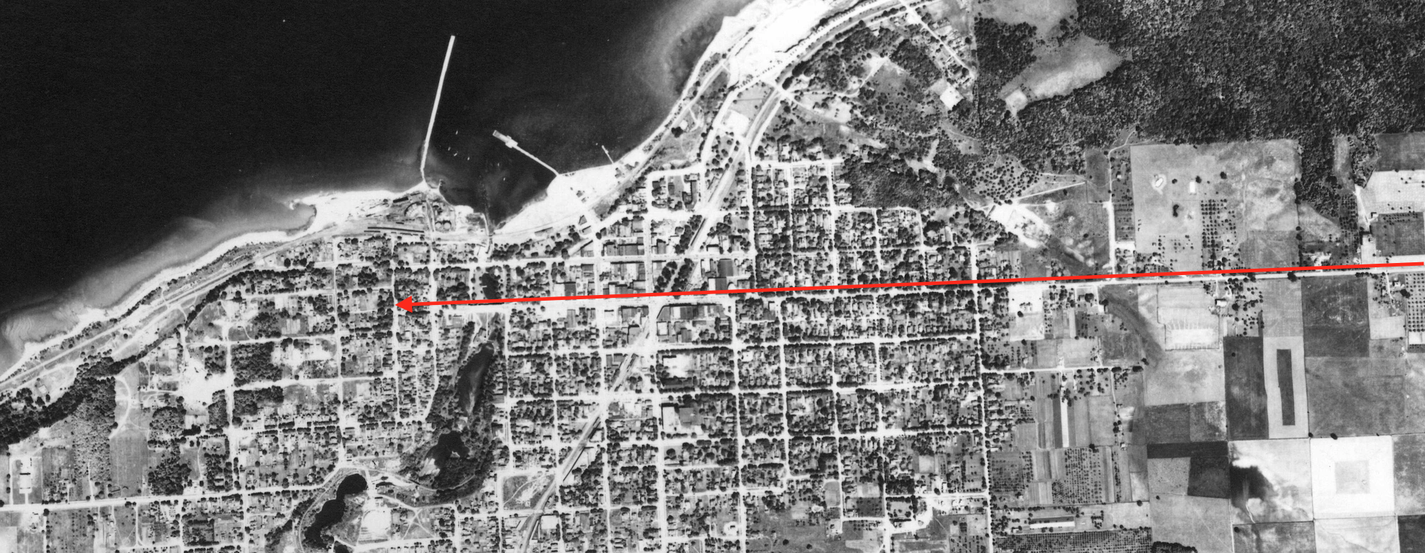
The Header Photo, and above, is a government aerial photo taken 11 July 1938 of Petoskey, Michigan.
The red arrow comes from East Mitchell Road in the east,
through Mitchell Street in Downtown Petoskey.
Then, the arrow heads west on West Mitchell Street, barely going over the Bear River,
to go past Wachtel Avenue,
only to DEAD END on Liberty Street
(in the heart of platted Emmet City).
The red arrow comes from East Mitchell Road in the east,
through Mitchell Street in Downtown Petoskey.
Then, the arrow heads west on West Mitchell Street, barely going over the Bear River,
to go past Wachtel Avenue,
only to DEAD END on Liberty Street
(in the heart of platted Emmet City).
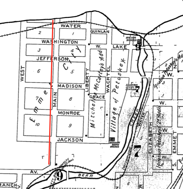
1885 Sanborn Map
Even the earliest Sanborn map in 1885 above shows Mitchell Street was first laid out to dead end at Liberty Street in platted Emmet City. In 1885 the Bear River had an easterly flowing outlet to Little Traverse Bay, different from the location of the mouth of the Bear River in 2023. The Bear River was redirected 10 November 1891, allowing for Lake Street later on to be gently realigned to go over a bridge on the river as shown on the 1896 map below. Mitchell Street continued to dead end into Liberty Street on the 1896 map below.
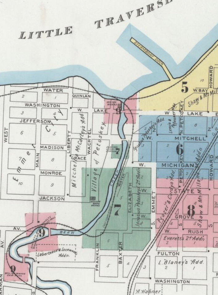
Image 1 of 1896 Sanborn Fire Insurance Map from Petoskey, Emmet County Michigan
~ Lake Street in 1875 or 1878 BEFORE 1891 River Realignment ~
(SAME PHOTO HAS HAD TWO DIFFERENT DATES)
Little Traverse Historical Museum Photo Archive
~ Lake Street in 1900 AFTER 1891 River Realignment ~

Allan McCune a successful Petoskey businessman and local historian donated several of his albums to Petoskey's Little Traverse Historical Museum. One of his albums included this photo of Petoskey, looking down Lake Street in 1900.
The 1908 article below reported how a runaway team of horses dragged the owner, Ed Brower, from the west end of Mitchell Street Bridge, until he was shaken loose "at the corner of Mitchell and Liberty streets. There the wagon struck a large rock at the inner corner of the intersection. Brower dropped unconscious with the runaways continuing on its course, right side up, and at last report was wildly traveling out the Charlevoix Road." That was the main route of travel at that time.
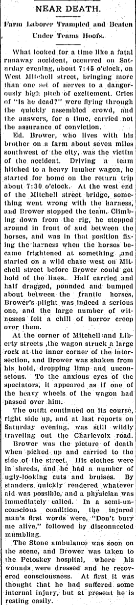
4 August 1908 ~ The Daily Resorter and Petoskey Evening News
~ Lake Street in 1910 AFTER 1891 River Realignment ~
(The Emmet County building was constructed in Petoskey in 1902)
(The Emmet County building was constructed in Petoskey in 1902)
Book Edited and Published by The Petoskey and Emmet County Improvement Association (1910)
When Lake Street was realigned, the Lake Street name was extended farther west, thus eliminating the 1885 and 1896 mapped west-side Washington street shown in the two maps farther above. Several of the streets on the west side of the river had names of U.S. Presidents; Jackson, Monroe, Madison, Jefferson, and Washington. Instead of totally eliminating the Washington street name when Lake Street extended on that location, (see 1907 Sanborn map below) the Washington street name continued east of the Bear River and became the very name of the street that dead ends beyond Franklin Street on the west end, and extends to Howard Street on the east end. Washington Avenue intersects Emmet street with longtime businesses Tom & Dick’s and Gold Mine Resale Shop located at the “Four Corners” in 2021.
1907 Sanborn Map
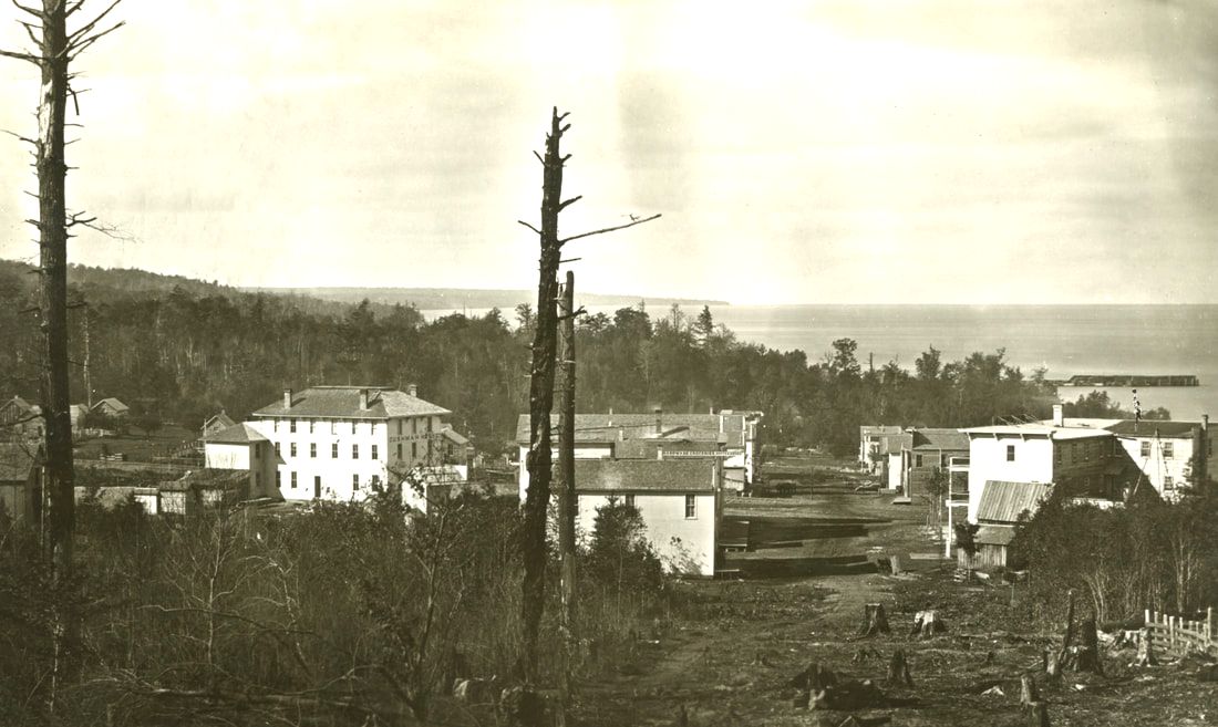
When Petoskey was first settled by white people in the late 1800's, it began with Andrew Porter's Mission Farm on the west side of the Bear River, and followed with Hazen Ingalls' trading post on the main street located on the west side of the Bear River. Settlement progressed with the vast amount of land that H.O. Rose owned on the east side of Bear River where he built his home (on Rose Street), a shipping dock, promoted his lime kiln in the area of Sunset Park, and built the Arlington Hotel, among many of his other community endeavors. Settlement in the Bear River area seemed to happen depending where entrepreneurs owned their own property.
6 February 1883 ~ The Northern Independent
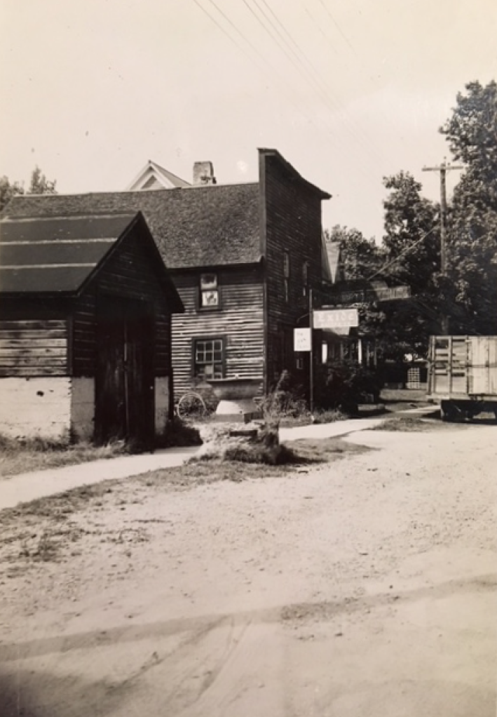
Photo Below: This is the first saw mill erected by Ingalls Brothers in Petoskey in 1879.
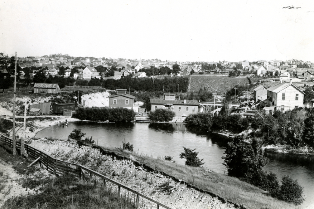
Little Traverse Historical Society Photo Collection (1879)
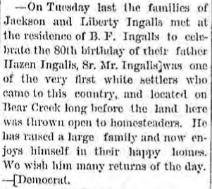
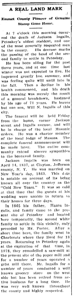
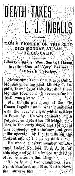
Jackson Ingalls' 9 February 1909 Petoskey Evening News obituary told of the beginnings of the Ingalls family in Petoskey as follows: "In 1865 Jackson's father Hazen Ingalls, and family came to the present site of Petoskey and located here temporarily, the second white family to settle in this vicinity, only preceded by Mr. Porter. After a short time here, the family went to Charlevoix where they lived for 13 years. Returning to Petoskey again at the expiration of that time, in 1878, they remodeled a saw-mill and for a number of years operated a grist mill there. Mr. Ingalls for a number of years conducted a well known grocery store on the west side but has been retired from active business for a long time... The funeral will be held from the home, corner Jackson street and Ingalls avenue..."
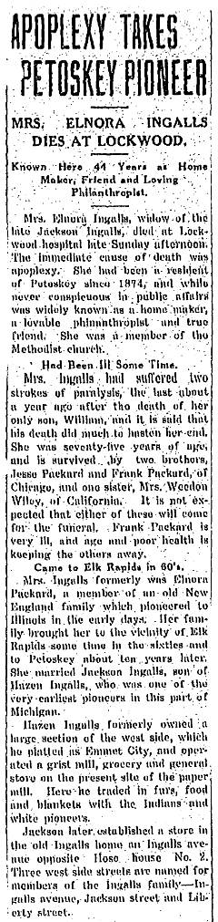
Jackson Ingalls' wife Elnora Ingalls' 21 October 1918 obituary told: "... Hazen Ingalls was one of the very earliest pioneers in this part of Michigan. Hazen Ingalls formerly owned a large section of the west side, which he platted as Emmet City, and operated a grist mill, grocery and general store on the present site of the paper mill. Here he traded in furs, food and blankets with the Indians and white pioneers. Jackson later established a store in the old Ingalls home on Ingalls Avenue opposite HoseHouse No. 2. Three west side streets are named for members of the Ingalls family – Ingalls Avenue, Jackson Street, and Liberty Street."
Jackson Ingalls' wife Elnora Ingalls' 21 October 1918 obituary told: "... Hazen Ingalls was one of the very earliest pioneers in this part of Michigan. Hazen Ingalls formerly owned a large section of the west side, which he platted as Emmet City, and operated a grist mill, grocery and general store on the present site of the paper mill. Here he traded in furs, food and blankets with the Indians and white pioneers. Jackson later established a store in the old Ingalls home on Ingalls Avenue opposite HoseHouse No. 2. Three west side streets are named for members of the Ingalls family – Ingalls Avenue, Jackson Street, and Liberty Street."
Patricia Heuvelhorst’s "Pioneers" Chapter in the 1986 Historical Glimpses Petoskey explained the street names of the West Side. “The elder Ingalls (Hazen) platted his own version of a village on the west side of the river, calling it Emmet City. Some streets were named for the family: Ingalls, [sons] Liberty and Jackson. Whether Jackson Ingalls had been named for President Andrew Jackson, who was in office for either years immediately prior to Jackson’s birth, or the common names were just coincidence, an idea seems to have struck Hazen’s fancy. He named the other east-west streets north of Jackson Street after other presidents; Monroe, Madison and Jefferson. The west side was still known as Emmet City as late as 1882 when the first directory of Petoskey was published. Today, city plat maps recognize that addition to the city as Emmet City."
Hazen Ingalls children were: Hibbard, Richard, Liberty, Hazen Jr., Byron, John (lived one hour after birth in 1919), Jackson, and Ione was a daughter, or daughter-in-law). The west does have an Ione Street in the Ingalls Street area. Jackson Ingalls built the frame store at 620 Ingalls Avenue, which was the first real store in this part of town. Jackson also built the large house on the south-west corner of Ingalls and Jackson streets. In the north gable was written "This is the house that Jack built" and the date "1896".
Hazen Ingalls children were: Hibbard, Richard, Liberty, Hazen Jr., Byron, John (lived one hour after birth in 1919), Jackson, and Ione was a daughter, or daughter-in-law). The west does have an Ione Street in the Ingalls Street area. Jackson Ingalls built the frame store at 620 Ingalls Avenue, which was the first real store in this part of town. Jackson also built the large house on the south-west corner of Ingalls and Jackson streets. In the north gable was written "This is the house that Jack built" and the date "1896".
|
Julia Hunter Ingalls, the wife of Hazen Ingalls, was born 30 March 1816, and died 29 March 1873. She was buried in Petoskey's Greenwood Cemetery.
Hazen Ingalls was born 1 January 1802 in Vermont, and died 17 November 1886 in Texas. He was buried in Petoskey's Greenwood Cemetery. 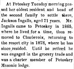
11 February 1909 ~ The Pellston Journal
|
9 February 1909 ~ Petoskey Evening News
|
21 October 1918 ~ Petoskey Evening News
|
5 January 1920 ~ Petoskey Evening News
|
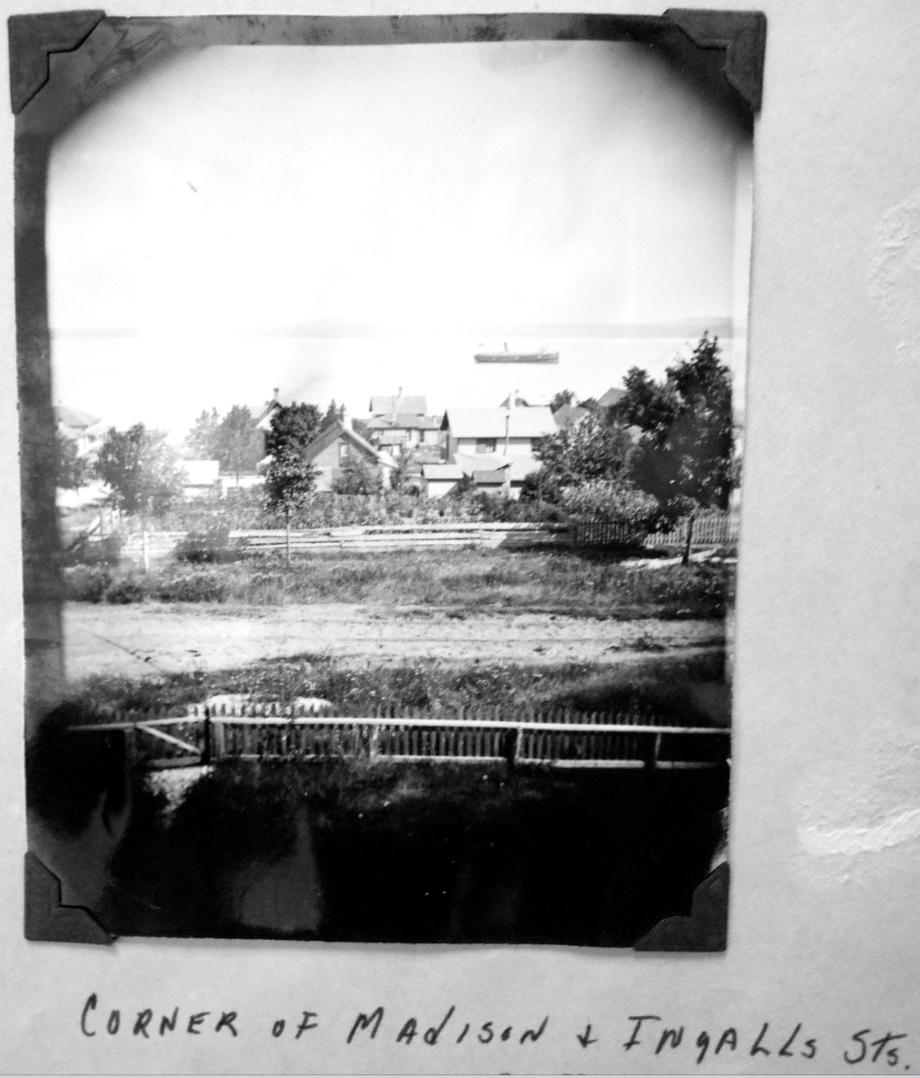
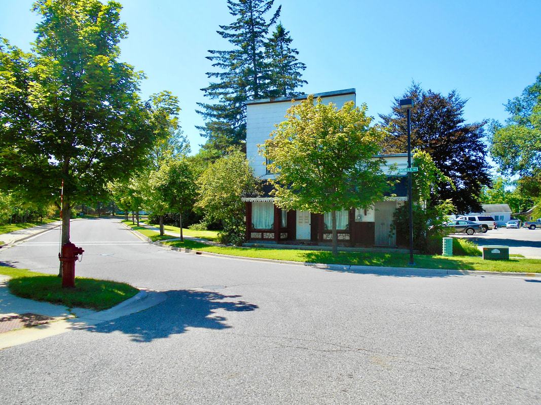
Allan McCune a successful Petoskey businessman and local historian donated several of his albums to Petoskey's Little Traverse Historical Museum. One of his albums included this photo of the Corner of Madison and Ingalls Streets (Undated)
Clipping Below: Do you remember...
10 July 1952 ~ Northern Michigan Review
for viewing only on this Northern Mich~Mash Preserve web site...
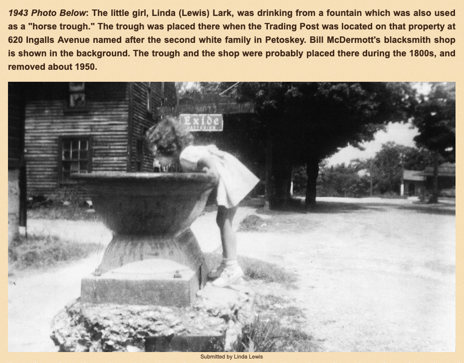
Linda Lewis told that because her father Ray Lewis' sign shop building had been the first Indian trading post, and probably one of the oldest buildings in that area of town, she and her siblings loved it when their dad had the garden plowed in the spring. That event gave them a chance to look for arrowheads and pieces of artifacts in the newly turn earth. She described her memory of the basement as interesting and a little spooky. Learn more about the Lewis Sign shop on the Ingall's 620 Ingalls Avenue location by clicking HERE.
14 August 2021
|
14 August 2021
|
Undated Photos Below:
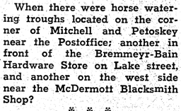
The same "horse trough"as in the photo above was located near the McDermott's blacksmith shop.
The fountain water was always flowing and very cold; perhaps from an artesian well.
The two men, working on a horse's shoe stood in front of McDermott's blacksmith shop.
The same "horse trough"as in the photo above was located near the McDermott's blacksmith shop.
The fountain water was always flowing and very cold; perhaps from an artesian well.
The two men, working on a horse's shoe stood in front of McDermott's blacksmith shop.
Submitted by Linda (Lewis) Lark for viewing only on this Northern Mich~Mash Preserve web site...
|
Submitted by Linda (Lewis) Lark for viewing only on this Northern Mich~Mash Preserve web site...
|
Photo Below Labeled: "1903 Ingalls Store on Ingalls Street"
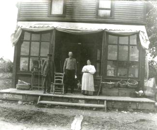
Little Traverse Historical Society Photo Collection (1903)
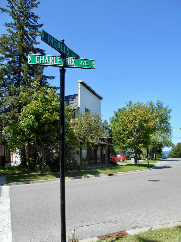
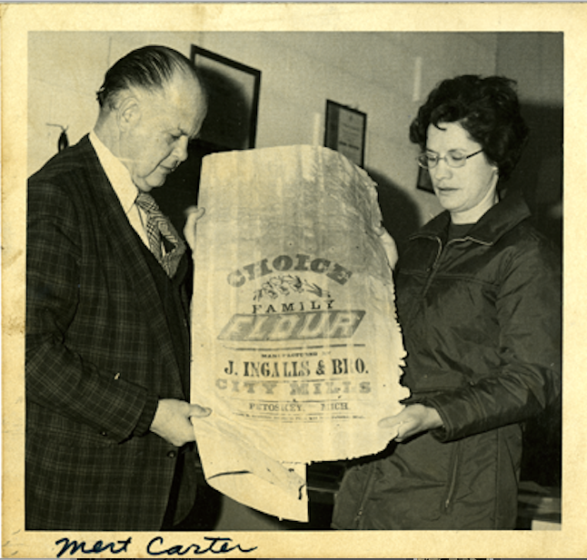
The “West Side” of Bear River had a street actually named Main Street. The 1884 publication of The Traverse Region stated, “Hazen Ingalls (b. 1802 d. 1886) was the first settler who came to Bear Creek for the purpose of making a home, and to apply his industry to local development. He first bought a saw mill which he transformed into a grist mill [Photo Below: Mert Carter held a J. Ingalls & Bro. Flour sack]. He established a small trading post on Main Street." Following the 1896 Sanborn map (below left), the next Sanborn map of 1901 (below right) labeled Ingalls Avenue with a notation stating “Formerly Main Street.” Ingalls Avenue extended from the waterfront to just around the sweeping corner at the bend of the river that harbored the Petoskey Fiber Paper Company where then, Ingalls Avenue swept into established named Charlevoix Avenue, just as it does in 2021; with no ninety degree angle to differentiate between the two avenue names. Hazen Ingalls lived in a house on the corner of Charlevoix and Ingalls avenues, until his dying day… 17 November 1886.
Little Traverse Historical Society Photo Collection
The Main to Ingalls Avenue name change had transpired,
while Mitchell Street continued to dead end at Liberty Street.
On the 1901 plat map, Liberty Street extended to the water's front of the bay.
In 2024 Liberty Street stops at Jefferson Street.
while Mitchell Street continued to dead end at Liberty Street.
On the 1901 plat map, Liberty Street extended to the water's front of the bay.
In 2024 Liberty Street stops at Jefferson Street.
1896 Sanborn Map label stated Main Street)
|
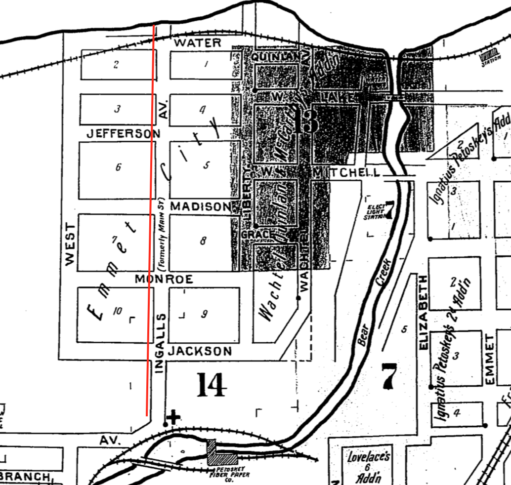
1901 Sanborn label stated Ingalls Avenue (Formerly Main Street)
|
At FIRST only a log traversed the Bear River to travel from one side or the other.
Actual Mitchell Street bridges were as follows (Click HERE for additional Mitchell Street bridge Information)
1) wooden bridge in late 1870s
2) wooden bridge rebuilt about 1885
3) steel structure about 1890
4) concrete structure in 1931 and remains in 2021
Petoskey no longer had a particular street named Main Street when the Petoskey Record 6 February 1907 issue published a letter signed "Petoskeyan" calling for Mitchell Street to be acknowledged as the main street! The letter told the following about Mitchell Street when considering a new bridge to be placed. "Mitchell street ought to be the main attractive street of Petoskey. Everything ought to be planned with that always in view. But Mitchell street never can be made an attractive main business street unless Mitchell street bridge is raised so as to make Mitchell street grade comparatively gentle. If the bridge is so raised, Mitchell street will be a very handsome street upon both sides of the river–a street whose appearance Petoskey will always be proud of. The lots on each side of the street and river are already higher than the street level. Raise the street grade and it will be a very great improvement to the looks of the city, while it will cost but little.
On the other hand, to lower the bridge level, even by a foot, would detract very cruelly from the good looks of Mitchell street and of the city of Petoskey as a whole."
On the other hand, to lower the bridge level, even by a foot, would detract very cruelly from the good looks of Mitchell street and of the city of Petoskey as a whole."
Photo Below:
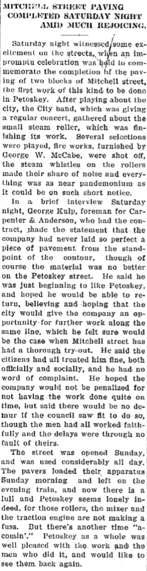
Main thoroughfare through Petoskey; FIRST paving of Mitchell and Liberty streets in 1922...
Main thoroughfare through Petoskey; FIRST paving of Mitchell and Liberty streets in 1922...
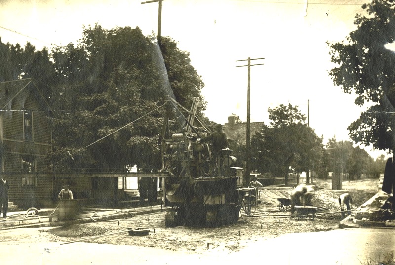
Little Traverse Historical Society Photo Collection (1922)
1929 Map Below: No one seemed to question the abrupt dead end of Mitchell Street [the main street of Petoskey] at Liberty Street. Two roads devolved in reaching Petoskey's main downtown and Mitchell Street. US-31 from Charlevoix entered from the west on old State Road, now known as Sheridan Street. Old State Road came across Bear River to Emmet Street. M-131 (earlier known as M-13) reached Mitchell Street from the southerly direction of Walloon Lake. M-131, now Bear River Road, was laid out next to the Pennsylvania Railroad track. So, in the early years M-131 came past the location of the old Petoskey High School stadium (not yet built on the 1929 map below), then across Standish Avenue Bridge, on to Emmet Street. Both M-31 and M-131 entered Mitchell Street from Emmet Street.

1929 Sanborn Map
1929 Map Above: The two main roads leading into Downtown Petoskey's Mitchell Street are marked with red arrows. The red arrow from the west (Charlevoix direction) followed State Road (Sheridan Street). The red arrow from the south (Walloon Lake direction) came from M-131 meeting to follow on Standish Avenue which suddenly swings into Emmet Street. Both the west and the south arrows meet at Emmet Street (at the corner of Emmet and State Road as shown below) which leads into Downtown Petoskey's main street...
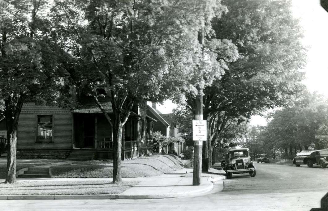
Undated Photo Below: The corner of Emmet and State Road (Sheridan Street now)
where the two main roads joined to approach Mitchell Street...
The road signs in the shape of a state road sign
probably are pointing out the directions of M-131 and US 31.
where the two main roads joined to approach Mitchell Street...
The road signs in the shape of a state road sign
probably are pointing out the directions of M-131 and US 31.
Submitted by Linda (Lewis) Lark for viewing only on this Northern Mich~Mash Preserve web site... (Undated)
... so, the joining of Emmet Street and Mitchell Street (thus both U.S. 31 and 131)
just as the advertisement below notes for the prime location of the Hotel Moyer.
just as the advertisement below notes for the prime location of the Hotel Moyer.
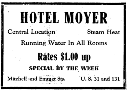
5 July 1933 ~ Petoskey Evening News
The following 1936 advertisement for
Fox's Standard Service on the corner of Mitchell and Emmet Street was noting
it was located on both U.S. 31 and M 131.
Fox's Standard Service on the corner of Mitchell and Emmet Street was noting
it was located on both U.S. 31 and M 131.
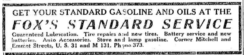
26 August 1936 ~ Northern Michigan Review
Photo Below Labeled: "Mitchell Street US 31 & US 131" signs...
Little Traverse Historical Society Photo Collection
~ NEW Mitchell Street Bridge, Petoskey, Mich. ~
(Concrete Bridge Constructed in 1931)
(Concrete Bridge Constructed in 1931)
 Greenwood Photo Archive Collection (Undated Postcard)
1930 Article Farther Below Left: Motorists were concerned about the future of the state trunk line from Kalkaska to Mancelona, while Petoskey and Northern Michigan residents were greatly interested in the proposed new Mitchell Street bridge over Bear River to be of concrete and to be constructed in 1931. While Mitchell Street was still a dead end at Liberty Street, the new bridge smoothly would link up the stretch of concrete paving north on US-31 and M-131 with the paving on US-31. Drivers from Mitchell Street, however, continued to travel to Charlevoix across the Mitchell Street bridge, by way of Liberty Street, then to turn west on Jackson Street quickly south on to Ingalls which morphed into Charlevoix Avenue, to turn south on either Spring Street, Greenwood Cemetery Road, or Eppler Road just past the Fairgrounds, with any of those three connecting to State Road.
It is noted with the State of Michigan that in 19 May 1931 that the Act 131 of 1931–the Dykstra Act–was passed allowing the State Highway Department to take control of state highways running into and through incorporated cities, thereby officially incorporating them as state trunkline highways. Thus, the following segment of formerly city-controlled streets were established as state trunkline highway route as part of US-31. "In Petoskey: A 0.5-mile segment through downtown consisting of Mitchell Street from Liberty Street easterly toHoward Street and Howard Street from Mitchell Street northerly to Bay Street."
It is noted with the State of Michigan that in 19 May 1931 that the Act 131 of 1931–the Dykstra Act–was passed allowing the State Highway Department to take control of state highways running into and through incorporated cities, thereby officially incorporating them as state trunkline highways. Thus, the following segment of formerly city-controlled streets were established as state trunkline highway route as part of US-31. "In Petoskey: A 0.5-mile segment through downtown consisting of Mitchell Street from Liberty Street easterly toHoward Street and Howard Street from Mitchell Street northerly to Bay Street."
|
Two 1931 Articles Below Center and Right: Also, an undated article stated, "Mr. Galster (Photo Right) conceived, organized, and financed the Petoskey Portland Cement Company with capital (See two photos below). He is now president and treasurer of this company. A little later he organized the Petoskey Transportation Company, of which he is also president and treasurer." Galster also was president of the "131 Paved Highway association." |
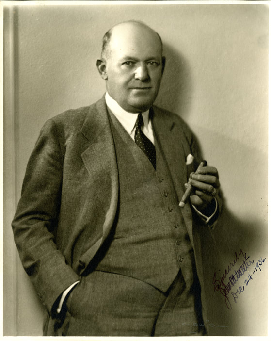
John L. A. Galster (24 December 1936) ~ Little Traverse Historical Museum Photo Archive
|
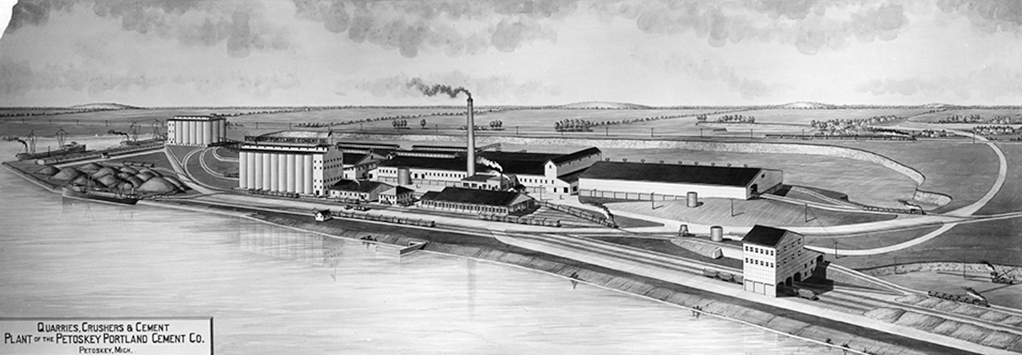
Allan McCune a successful Petoskey businessman and local historian donated several of his albums to Petoskey's Little Traverse Historical Museum. One of his albums included this drawing of the Petoskey Portland Cement Co.
Petoskey Portland Cement Company ~ Little Traverse Historical Museum Photo Archive

17 November 1930 ~ Petoskey Evening News
|

27 January 1931 ~ Petoskey Evening News
|
2 February 1931 ~ Petoskey Evening News
|
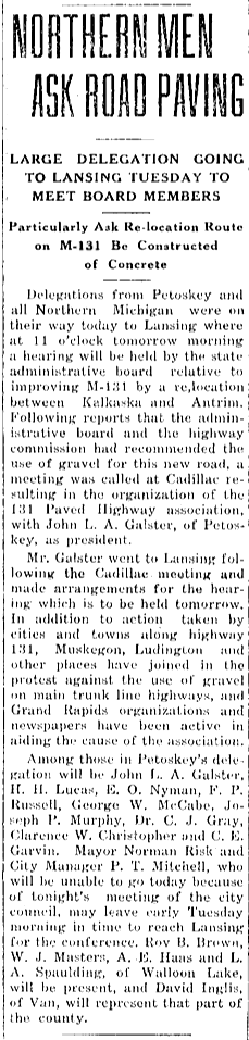
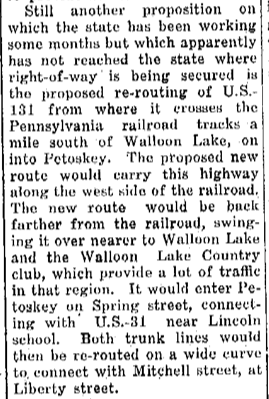
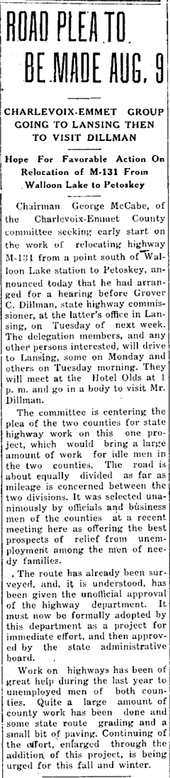
Article Below Left: The new route for US-131, proposed replacing M-131 (Bear River Road), by placing the highway closer to Walloon Lake, with a connection and an entrance into Petoskey on Spring Street, rather than entering on Standish Avenue to Emmet Street to reach downtown's Mitchell Street.
~ Touted Advantages of the Relocation of US-131 ~
1931 Article Below Center: The relocation of highway M-131 was gaining steam for a few reasons. The project would involve both Charlevoix and Emmet Counties, bringing a large amount of work for idle men. The Great Depression had intensified the need for "relief from unemployment among the men of needy families."
1932 Article Below Right: The proposed relocation of M-131 offered other advantages besides unemployment relief. “The new route would eliminate four railroad crossings, place the highway on high ground and away from the present swamp stretches… bring the road nearer to the Walloon Lake resorts and therefore make it of greater general value.”
17 December 1931 ~ Petoskey Evening News
|
6 August 1932 ~ Petoskey Evening News
|

9 August 1932 ~ Petoskey Evening News
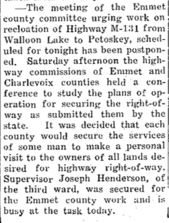
1932 Article Below: Emmet and Charlevoix counties' highway commissions were studying plans of operation for securing the necessary right-of-way to proceed with the relocation of M-131.
22 August 1932 ~ Petoskey Evening News
|
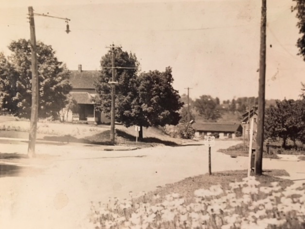
Photo Below: PRE 1939 with no hospital and no relocation of US-31 and M-131...
DEAD END MITCHELL STREET
DEAD END MITCHELL STREET

(PRE 1939) PRE-Hospital and PRE-Relocation of M-131 ~ DEAD END MITCHELL STREET (Marked with red dot)
~ Touted Disadvantages of the Relocation of US-131 ~
1932 Article Farther Below: The Emmet County supervisors voted unanimously for the county highway board to purchase right of way needed to complete the county's part of the relocation of M-131 south of the city. Several citizens voiced displeasure that the present M-131 route that paralleled the Pennsylvania tracks would be moved toward Walloon Lake and enter the Petoskey city limits at Spring Street. The citizens' opposition to the plan stated "the change would hurt the Emmet Street and west side [business] districts and divert automobile traffic over to US-31 and thence south without really entering the city."
The corner of the Dead End at Mitchell Street and Liberty Street, for instance, had been vibrant for years, and has remained so even into 2020.
2020 Photo Below: Corner of East Mitchell and Liberty streets, Petoskey, Michigan.
The building on the right presently houses Farmers Insurance.
The building on the right presently houses Farmers Insurance.
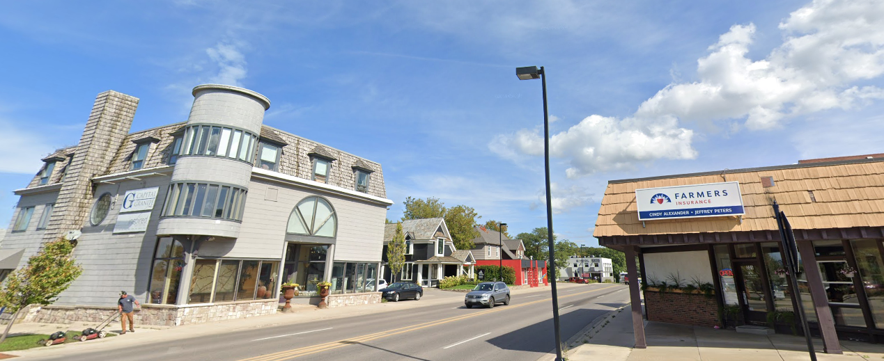
Captured (8 April 2020) from on-line Google Street View of Mitchell Street, same view as PRE-1911 photo below...
In the 2020 photo above, the buildings on the left side of Mitchell are; Capital Granite, Young & Meathe ~ Custom Homes Restoration, and the red building which used to house Ingrid's Hair Salon. Compare the Capital Granite building to the same building (in the next photo below) which, even before 1911, housed Comstock & Son Dry Goods. Also, next door to the Comstock store... the house with the entryway arches, of small stones, which were a landmark design, is now the Young & Meathe house/business which was redone and eliminated the stone arches, in the recent years. The house previously had been Flowers From Nature's Garden, a floral store.
|
This photo below of Herb Bartlett driving a team of horses on "unpaved" Mitchell Street, in front of the Comstock & Son store, was taken before 1911 when the right news article reported about the paving of Mitchell Street sections. Herb was a relative of Iris (Lewis) Worden's husband Earl.

Postcard Submitted by Linda (Lewis) Lark with permission to use only on this Northern Mich~Mash Preserve web site...
Photo Below:
Comstock and Weed store was located at 220 West Mitchell Street. 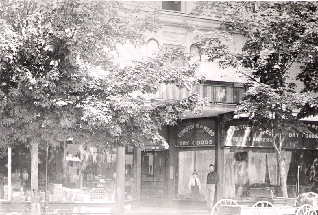
Little Traverse Historical Society Photo Collection (Undated)
|
26 June 1911 ~ Petoskey Evening News
|
Photo Below: Over the years, the corner store became Neuman's Grocery,
and later was a music store and a bicycle store,
before becoming the present Capital Granite.
and later was a music store and a bicycle store,
before becoming the present Capital Granite.
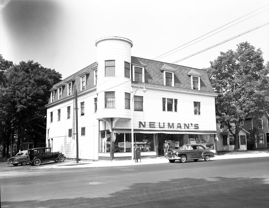
Greenwood Photo Archive Collection from Petoskey newspapers (Undated)
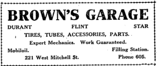
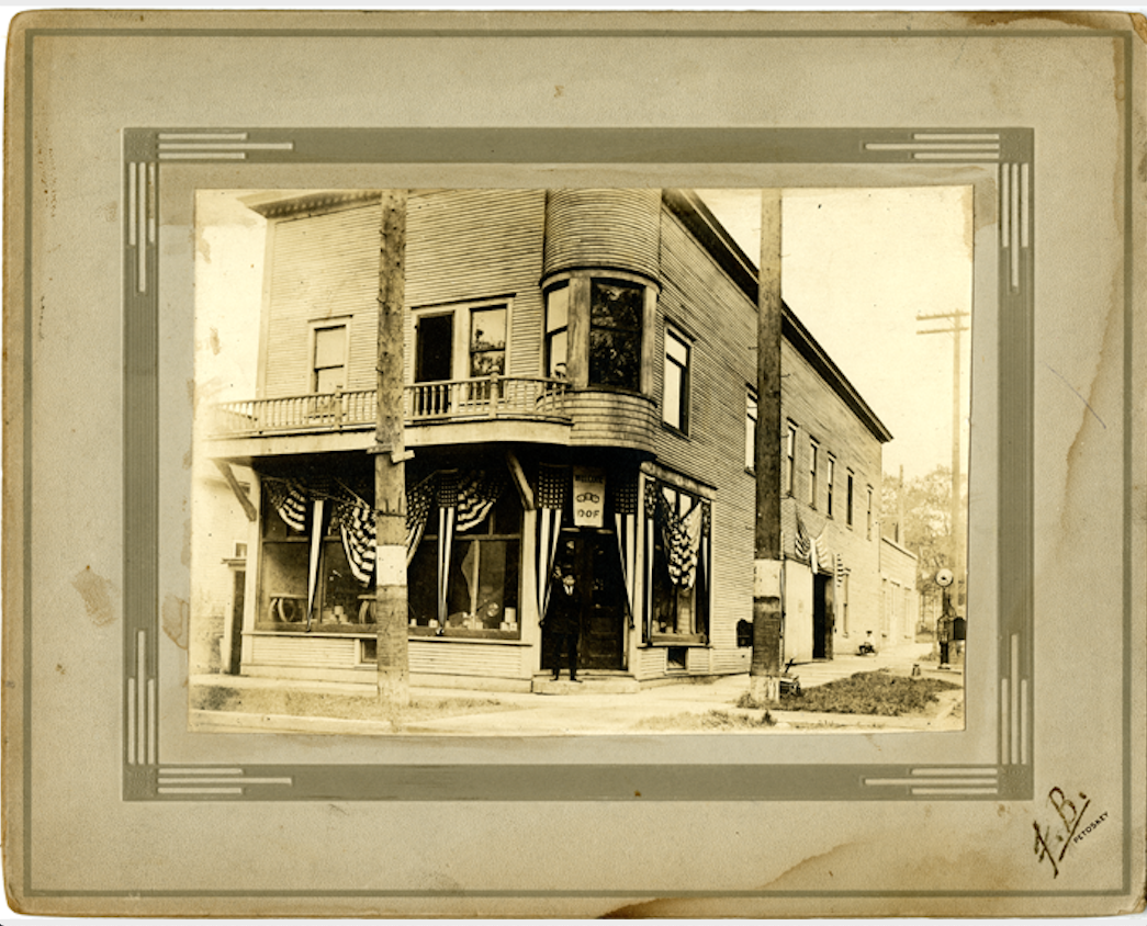
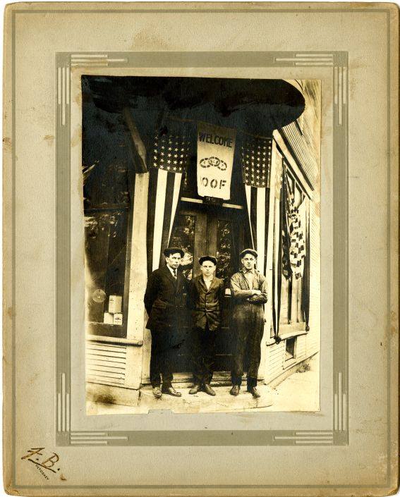
Photos Below: That 2020 Farmers Insurance location (221 West Mitchell Street) was years ago the home of a gas station and garage operated by Alfred J. Brown. The two photos below show Alfred, Thad, and Lyman Brown in front of Brown's Garage on the corner of Liberty and Mitchell streets. Previous to that, Alfred was employed for many years as a mechanic for his brother Benjamin Brown in Charlevoix.
20 April 1922 ~ Petoskey Evening News
7 August 1924 ~ Petoskey Evening News
Little Traverse Historical Society Photo Collection (PRE 1932)
|
Little Traverse Historical Society Photo Collection (PRE 1932)
|
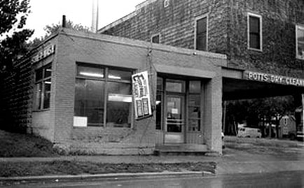
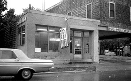
Photo Below: Linda (Potts) Balderson's family owned one of the vibrant businesses (Potts Laundry & Dry Cleaners) in the area of the Dead End, at the time of the US 131 and US 31 road relocation through Petoskey. Because their location was on the south-east corner of Mitchell and Liberty streets their building did not have to be razed or moved like the other area properties that were purchased as Rights-of-Way by the city for the new relocation route. Linda told: "My grandfather, Floyd Potts, Sr., son of David Albion Potts and Emma Julia (Thebolt) Potts, started the Potts Laundry. When the paper mill closed in Petoskey sometime after 1921, he and my grandmother started taking in laundry at their house on Grove Street. They called their business Modern Home Laundry. Business grew, and after 1923, they bought an old canning factory on West Lake Street, naming it Potts Laundry. They added dry cleaning and had an apartment upstairs. The building burned to the ground on March 8,1932, while five of the Potts children were at school. Dana was a baby at home. They lost everything. My grandfather then bought the Brown Motors building at 221 E Mitchell Street where the Potts family lived upstairs in one of the two apartments. The business was owned by my dad, Floyd, Jr., brother Dana Potts, and brother-in-law Don Ernst. Dana drowned, and my dad bought out Don Ernst’s share of the business. This photo below of the building was taken August 1944, so taken after the relocation of the roadway. Standing in front of the business are my dad, my mom and my grandfather."
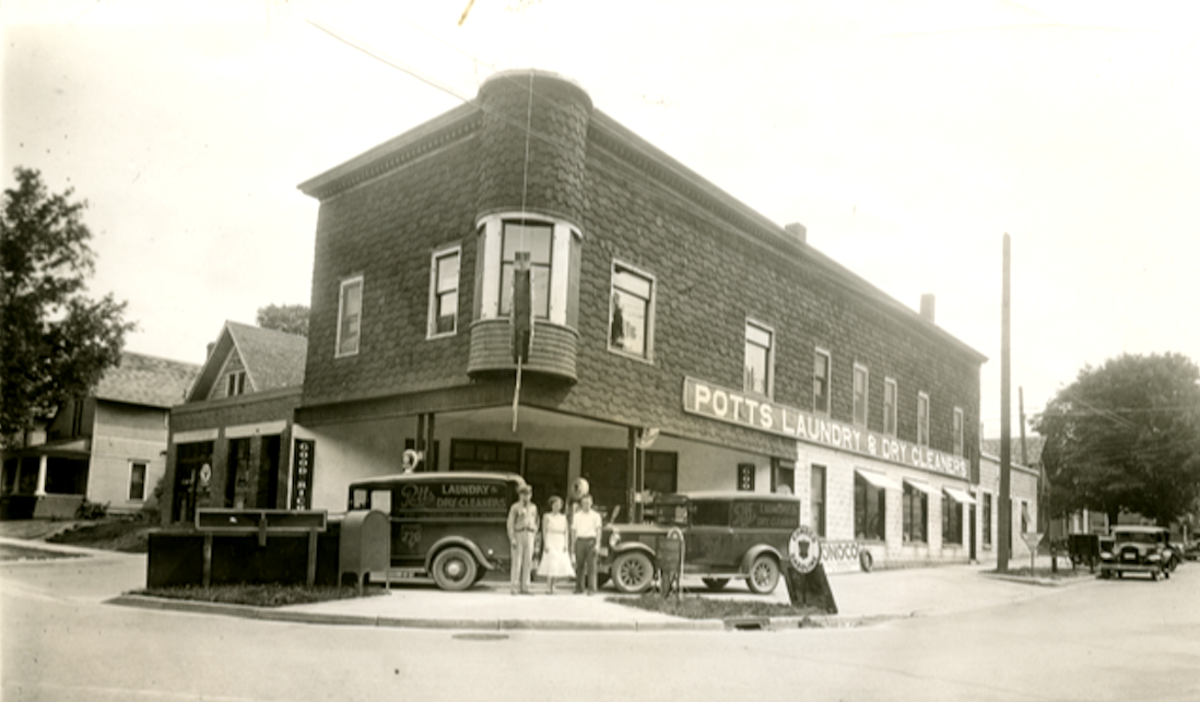
Family Photo Submitted by Linda (Potts) Balderson with permission to use only on this Northern Mich~Mash Preserve web site...
Greenwood Photo Archive Collection from Petoskey newspapers (30 July 1966)
|
Greenwood Photo Archive Collection from Petoskey newspapers (30 July 1966)
|
~ Touted Advantages of the Relocation of US-131 ~
1932 Article Below: Speakers in favor of the relocation pointed out that the labor wages would "materially reduce the requirements necessary for the county poor fund." John L.A. Galster praised that the plan would spend nearly a quarter of a million dollars on labor directly, and for labor in the manufacture of materials. George McCabe of the county road commission saw advantages to the new road as 1) eliminating four railroad crossings 2) road with no turns nor steep grades 3) closer to the north arm of Walloon Lake 4) wages for the labor for the unemployed. Any new location change would affect negatively the entire project as the work must be started in December, and completed by July, 1, 1933.

26 September 1932 ~ Petoskey Evening News
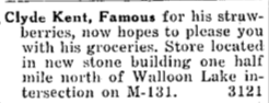
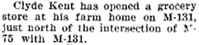
1932 Article Below Left: The Charlevoix County road commission did fine with all rights of way except across the Clyde Kent fruit farm just south of Clarion on the road to Walloon Lake. Emmet County had several strips of land where the ownership was held in estates, and not yet closed, so needed to go through the courts. Much later, on 23 July 1936, Clyde Kent was able to advertise he had opened a grocery store at his farm home on M-131, just off M-75 (through Walloon Lake).
15 July 1936 ~ Northern Michigan Review
|
23 July 1936 ~ Northern Michigan Review
|
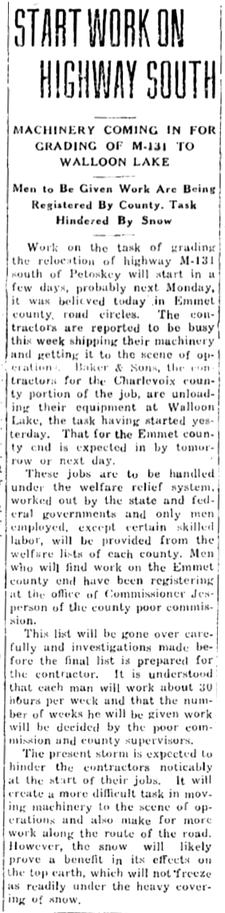
1932 Article Below Center: Work on the task of grading the relocation of M-131 south of Petoskey would start in a few days with the jobs to be handled under the welfare relief system.
An 11 July 1933 Petoskey Evening News article announced, "The old route of M-131 south of Petoskey to Walloon Lake was officially cancelled and the new route now under grade will become the 'official route."
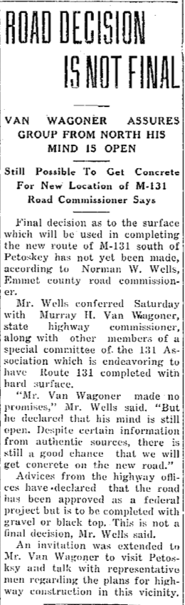
1933 Article Below Right: Emmet County wants local cement used for new highway, but "highway offices have declared that the road has been approved as a federal project... to be completed with gravel or black top. 'This is not a final decision,' Mr. Wells (Emmet County Road Commissioner) said."
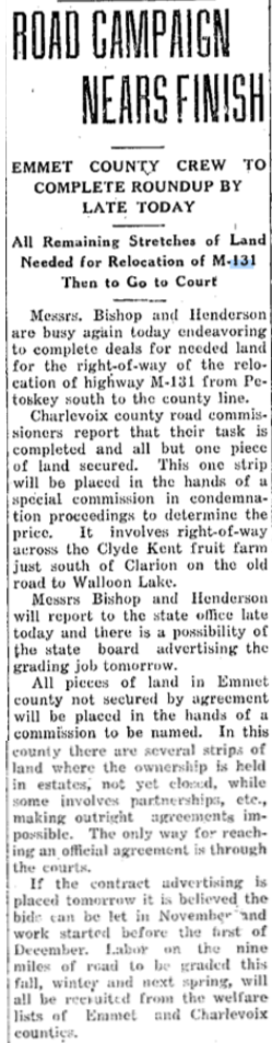
18 October 1932 ~ Petoskey Evening News
|
14 December 1932 ~ Petoskey Evening News
|
28 August 1933 ~ Petoskey Evening News
|
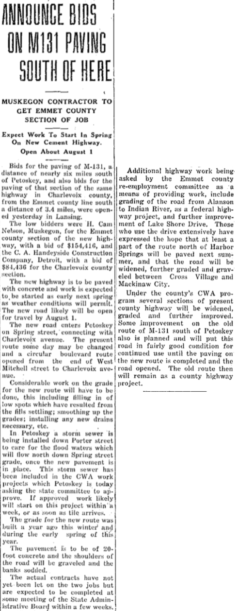
1933 Article Below Left: "The new highway is to be paved with concrete... The new road enters Petoskey on Spring Street, connecting with Charlevoix Avenue." Considerable work was left to be done like filling in low spots, smoothing grades, and installing new drains. The project included "a storm sewer being installed down Porter Street to care for the flood waters which will flow down Spring Street grade, once the new pavement is in place.... Some improvement on the old route of M-131 (Bear River Road in 2020) south of Petoskey also is planned and will put this road in fairly good condition for continued use until the paving on the new route is completed and the road opened. The old route then will remain as a county highway project." Mitchell Street remained a dead end.
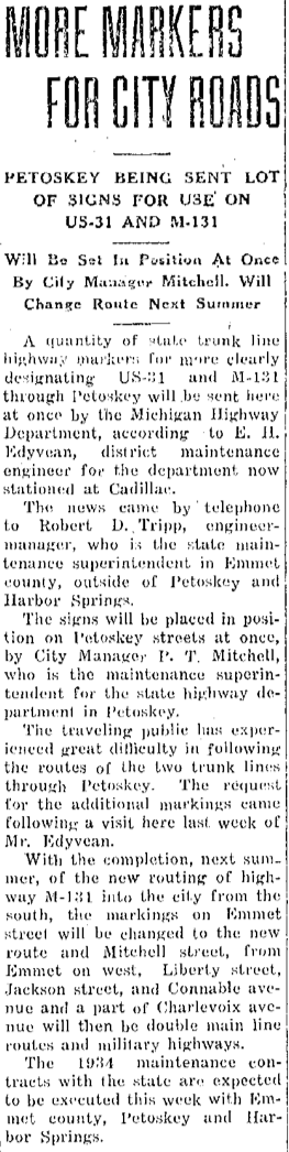
1934 Article Below Center: Because travelers had experienced great difficulty in following the routes of the two trunk lines through Petoskey, the city was to be sent additional road markings. The completion of the new M-131 routing was anticipated for the following summer. Markings on Emmet Street would be changed because Liberty Street, Jackson Street, and Connable Avenue, and a part of Charlevoix Avenue would be "double main line routes (US-31 and M-131) and military highways." That route would carry the traffic from Liberty Street where it met up with the dead end of Mitchell Street.
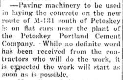
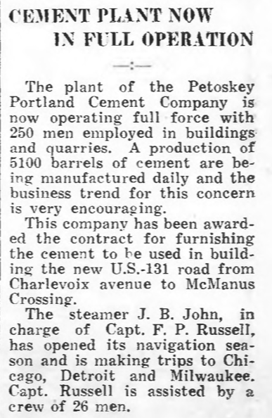
1934 Three Articles Below Right: Paving machinery had arrived on railroad flat cars near the Petoskey Portland Cement Company. By May the cement plant, which had been awarded the contract for the relocation of M-131, was operating with full force with 250 men employed. Grading and leveling had been transpiring, readying for large supplies of cement.
2 December 1933 ~ Petoskey Evening News
|
7 February 1934 ~ Petoskey Evening News
|
12 April 1934 ~ Petoskey Evening News
23 May 1934 ~ Petoskey Evening News
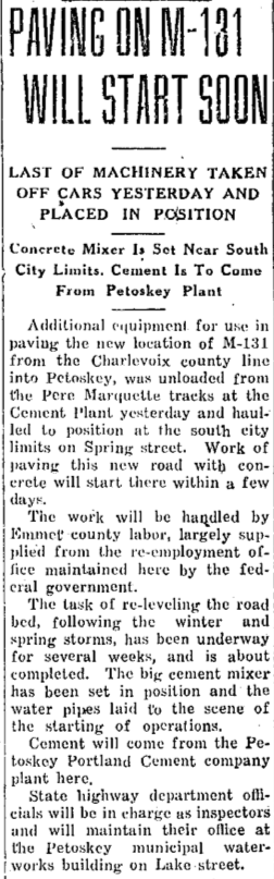
23 May 1934 ~ Petoskey Evening News
|
TOP
~ Paving is Moving Forward ~
1934
1934
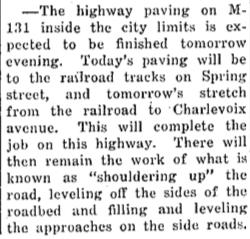
With 455 men on the M-131 Paving Project, in June of 1934,
the July 1934 news article below already was announcing that the paving work was nearly done.
the July 1934 news article below already was announcing that the paving work was nearly done.
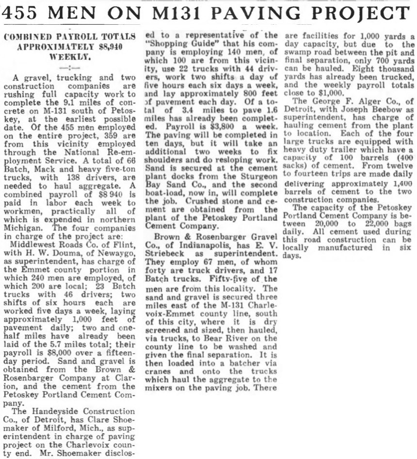
27 June 1934 ~ Northern Michigan Shopping Guide
|

14 July 1934 ~ Petoskey Evening News
|
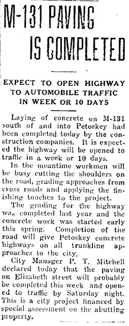
~ M-131 Scenic Views ~
"The road, now open to traffic presents a scenic drive into Petoskey from the south and gives the city concrete approaches on all three trunkline entrances."
Undated Photo Below taken by local photographer John R. Foley: Mr. Foley's career spanned from 1905 to 1946 so this photo likely was captured during the time frame of the new M-131 from Walloon Lake of one of the most scenic views of this overlook of Petoskey and Little Traverse Bay... over the then still open fields.
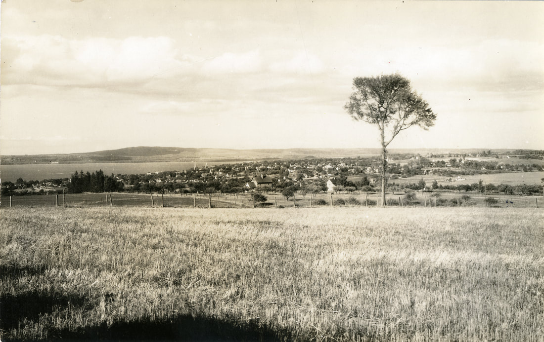
Undated Photo by John R. Foley ~ Little Traverse Historical Society Photo Archive
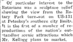
Two Articles Below: The Rotary Club instigated the Rotary Park on M-131
which for years had the very view as shown in Foley's vista photo above.
which for years had the very view as shown in Foley's vista photo above.
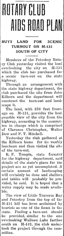
15 October 1936 ~ Petoskey Evening News
|
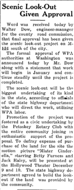
1 December 1936 ~ Petoskey Evening News
A 5 February 1948 Petoskey Evening News article about Petoskey sculptor Stanley Kellogg highlighted the natural beauty of the Rotary Park overlook as pictured in the Foley photo above when it stated:
5 February 1948 ~ Petoskey Evening News
|
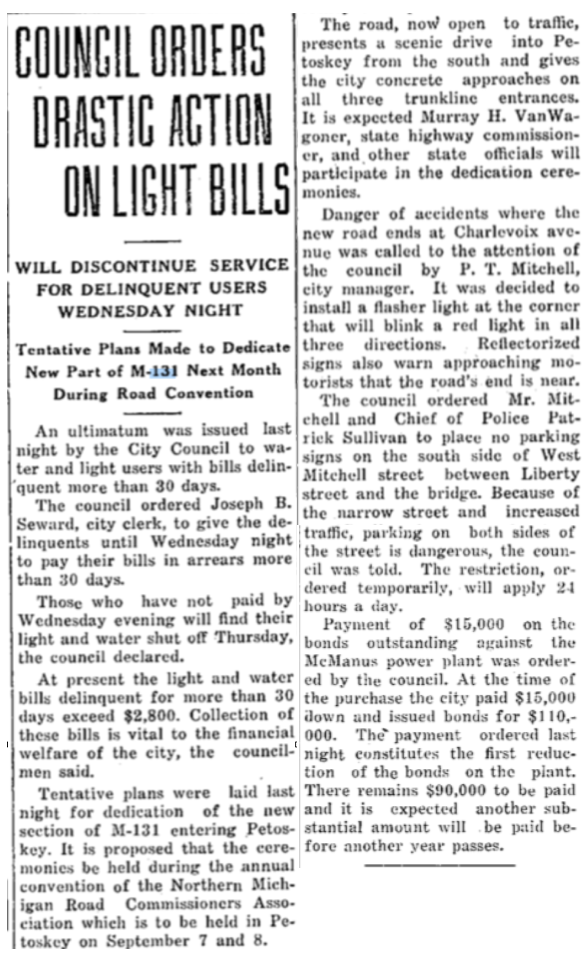
1934 Article Below Right: A NEW concern regarding NEW M-131 route was voiced as a "Danger of accidents where the new road ends at Charlevoix Avenue. It was decided to install a flasher light at the corner that will blink a red light in all three direction. Reflectorized signs also warn approaching motorists that the road's end is near." No parking signs were to be placed on the south side of West Mitchell Street (still a dead end) between Liberty Street and the bridge. Because of the narrow street and increased traffic, parking on both sides of West Mitchell Street and increased traffic, parking on both sides of the street would be dangerous. Although those were temporary restrictions, they applied around the clock.
27 July 1934 ~ Petoskey Evening News
2 August 1934 ~ Petoskey Evening News
|
21 Auguat 1934 ~ Petoskey Evenng News
|
Article Below: "...it is the most beautiful strip of trunk line highway in the north and reaching to the top of a range of hills affords one a bird's eye view of a great lot of interesting country all about, and one sees for miles around." AND "In this road building John Galster's magic touch again asserted itself from the beginning and he never relinquished that touch until the road was definitely promised to be built of cement."
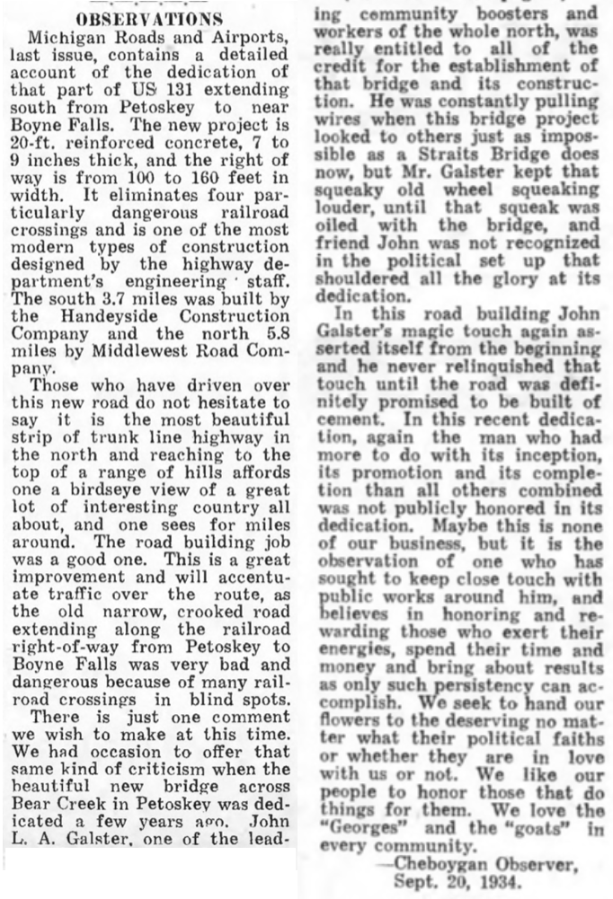
26 September 1934 ~ Northern Michigan Shopping Guide
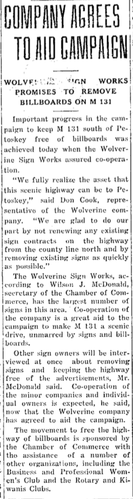
1935 Article Below Left: Wolverine Sign Works company stated, "We fully realize the asset that this scenic highway can be to Petoskey... We are glad to do our part by not renewing any existing sign contracts on the highway from the county line north (Emmet County) and by removing existing signs as quickly as possible."
|
1935 Article Below Right: "The Emmet County highway department has received authorization to landscape a section of the roadside at a point about four miles south of the city, where a wonderful view of Walloon Lake is afforded.... It is said that this point affords one of the finest views of beautiful Walloon Lake and the lake valley region of any place on any highway about the lake." |
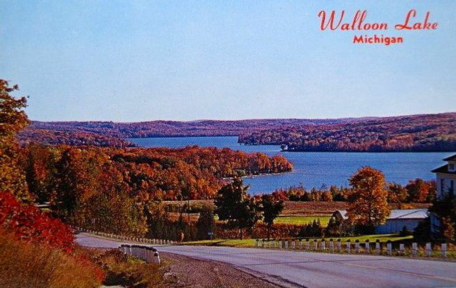
Postcard of the North Arm of Walloon Lake from the top of a hill on M-131 as noted in the article below right...
|
2 May 1935 ~ Petoskey Evening News
|

2 May 1935 ~ Petoskey Evening News
|
The stage had been set for an End to the Dead End of Mitchell Street,
by Re-routing M-131 and US-31 through Petoskey.
by Re-routing M-131 and US-31 through Petoskey.
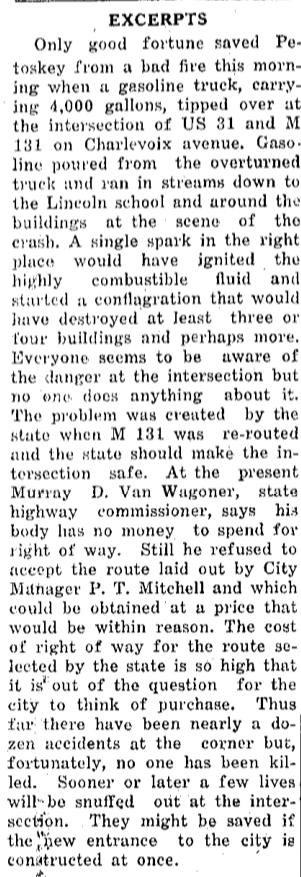
Two 1935 Articles Below Center: As beautifully as the trunkline had been transformed, when M-131 from the south of Petoskey had been completed to the dead end and ninety degree corner of Charlevoix Avenue to head west, accidents crashed on to the scene! The driver that hit the corner cabin with sleepers inside and knocked the cabin four feet off its foundation, stated, even with several warning signs and flashing lights, "I had no idea the street came to an abrupt end." This had been the fourth accident of the year that drivers suffered accidents at the intersection of the two trunk lines.
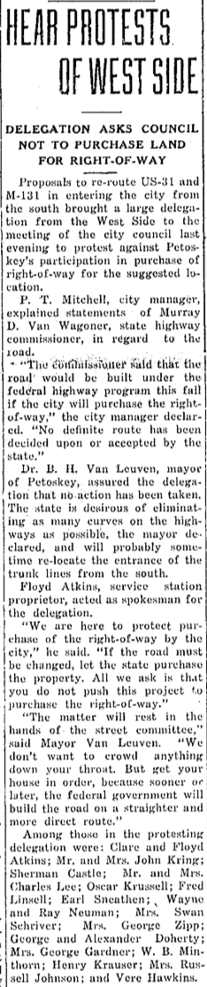
1935 Article Below Left: A couple of months previous to the September Crash happening articles, the city manager P.T. Mitchell explained that the state was proposing to re-route US-31 and M-131 entering the city from the south. A large delegation of West Side citizens protested the move proposing to circumvent the streets of the West Side businesses. The delegation discouraged having the city's funds, rather than the use of state or federal funds, to be used for purchasing the right-of-way for the suggested relocation.
At the end of the Crash article below center it was stated: “The road should keep on straight, according to the original plans of the highway department to have it circle around to meet the end of Mitchell Street.” The article went on to say, “P.T. Mitchell had made a complete survey of the project, interviewing all property owners. Action should be taken at once to build the new road. It should not be necessary to kill several people to remove this traffic hazard.”
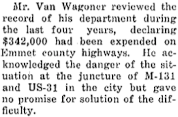
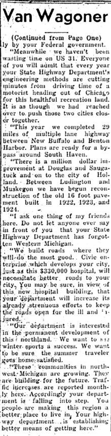
1935 Article Below Right: Murray D. Van Wagoner, state highway commissioner, referred to the Petoskey Evening News 17 October 1935 Editorial (shown farther below) and then acknowledged the accident prone intersection, but proclaimed he "can't see at this time how we [the state] can finance the right-of-way purchases."
4 June 1935 ~ Petoskey Evening News
|
|


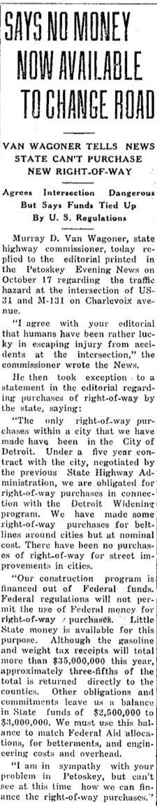

17 October 1935 ~ Petoskey Evening News (Editorial)
Article Section Below: Two years after Mr. Van Wagoner had told Petoskey no money was available for the dangerous M-131 and US-31 intersection, he reiterated the same condition; for the situation to be followed only three months later by another horrific accident (next article below).
27 February 1937 ~ Petoskey Evening News
11 May 1937 ~ Petoskey Evening News
|
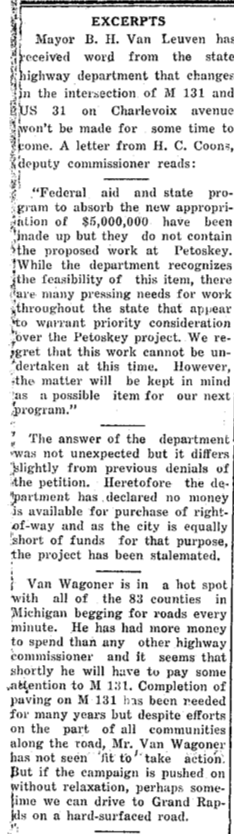
1937 Articles Below and Right: Businessmen wasted no time after the dangerous intersection accident reported above, to seek action regarding the highway, from the Lansing Department with Van Wagoner. By 11 August 1937, the entire community of Petoskey had received word from the state highway department that "changes in the intersection of M-131 and US-31 on Charlevoix Avenue won't be made for some time to come."
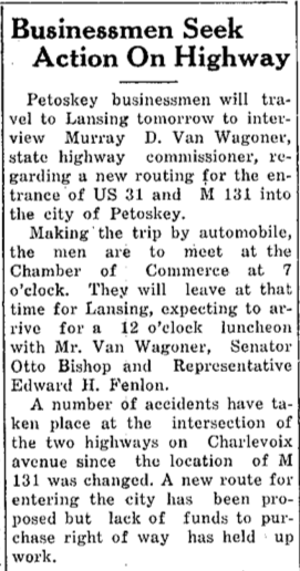
17 May 1937 ~ Petoskey Evening News
|
3 June 1937 ~ Kalkaska's Leader newpaper
|
11 August 1937 ~ Petoskey Evening News
|
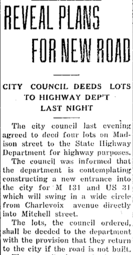
1938 Article Below: AND... so it began. "The city council last evening agreed to deed four lots on Madison Street to the State Highway Department for highway purposes. The council was informed that the department is contemplating constructing a new entrance into the city for M-131 and US-31 which will swing in a wide circle from Charlevoix Avenue directly into Mitchell Street [leading to the end of the dead end of Mitchell Street]."
8 February 1938 ~ Petoskey Evening News
|
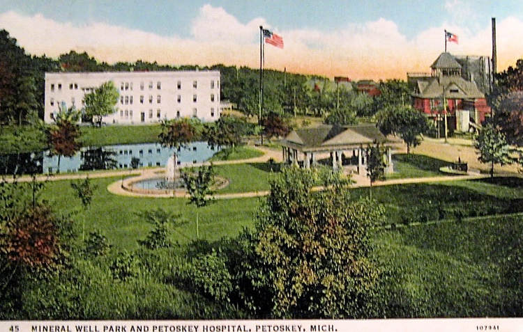
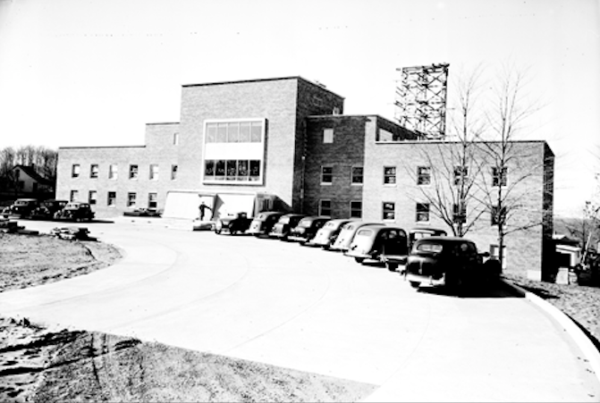
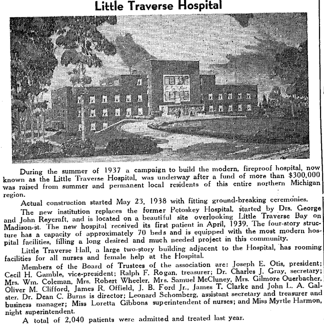
Postcard Above: In 1921, this fifth Petoskey Hospital was located on the Bear River which fed out of Walloon Lake, just before emptying into Little Traverse Bay beside Petoskey. This hospital was a converted hotel; originally built in 1902 with a capacity for 100 guests. The original hotel, named the Haertal Inn, was owned by Harry Haertal. In 1915 it was sold to George and Corbett W. Doherty who were meat dealers. Next, it became the Grand Hotel at 105 West Lake Street. It was purchased by the Drs. George and John Reycraft for a hospital in 1921. The Petoskey Hospital in the postcard above shows on the front left with its building reflected in the river and operated as a hospital until 1939. The NEW Little Traverse Hospital (being constructed in 1938) would fit into the roadway location for the relocation of M-131 and US-31 as revealed in the 1938 article farther below.
|
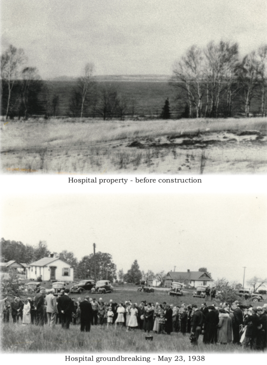
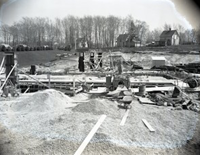
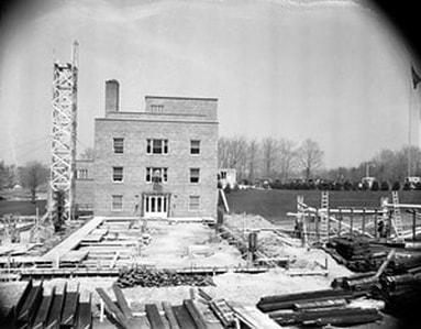
Photos Below: Vacant property to become the hospital's location...
PRE-roadway extension from dead-end Myrtle Street
1938
PRE-roadway extension from dead-end Myrtle Street
1938
Greenwood History Collection for Dr. Burns
|
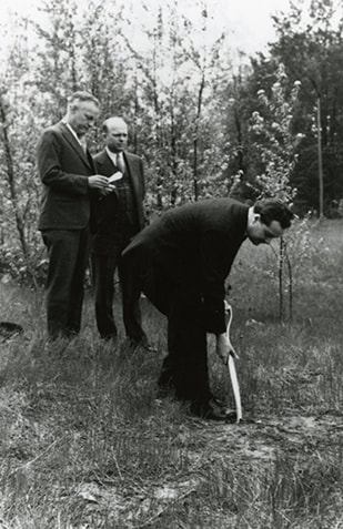
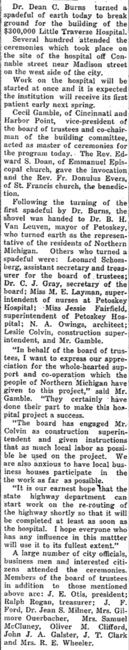
Dr. Burns breaking ground for the new hospital ~ Little Traverse Historical Society Photo Collection (1938)
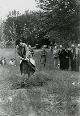
Ground breaking ground for the new hospital ~ Little Traverse Historical Society Photo Collection (1938)
|
1938 Article Below: Public attention was being called to the needs of the entire lengths of M-131 and US-31 stating "Appearing on the road maps as a gravel road, M-131 is branded dusty and undesirable by the motoring public visiting this section. It is the only unpaved section of road between Petoskey and points in Florida." Slipped into this article, the big news, which evidently had been discussed previously at some point, about a new entry into Petoskey, stated: "The matter of the intersection of M-131 and US-31 at Petoskey is also of concern to residents of the city. Repeated accidents have shown it to be dangerous and it is extraordinary that no one has been killed at the crossing. With the construction of the Little Traverse Hospital assured, it should not be hard to lay out the route for a long slow curve which would bring the two trunklines together in a safer manner and also give a more attractive and less twisting entry into Petoskey." No mention in the local newspapers of a significant link between the routing of the entrance into Petoskey, and the construction of a new hospital, previously had been reported. The 1938 hospital was the same building located by the Bear River as in the postcard above.
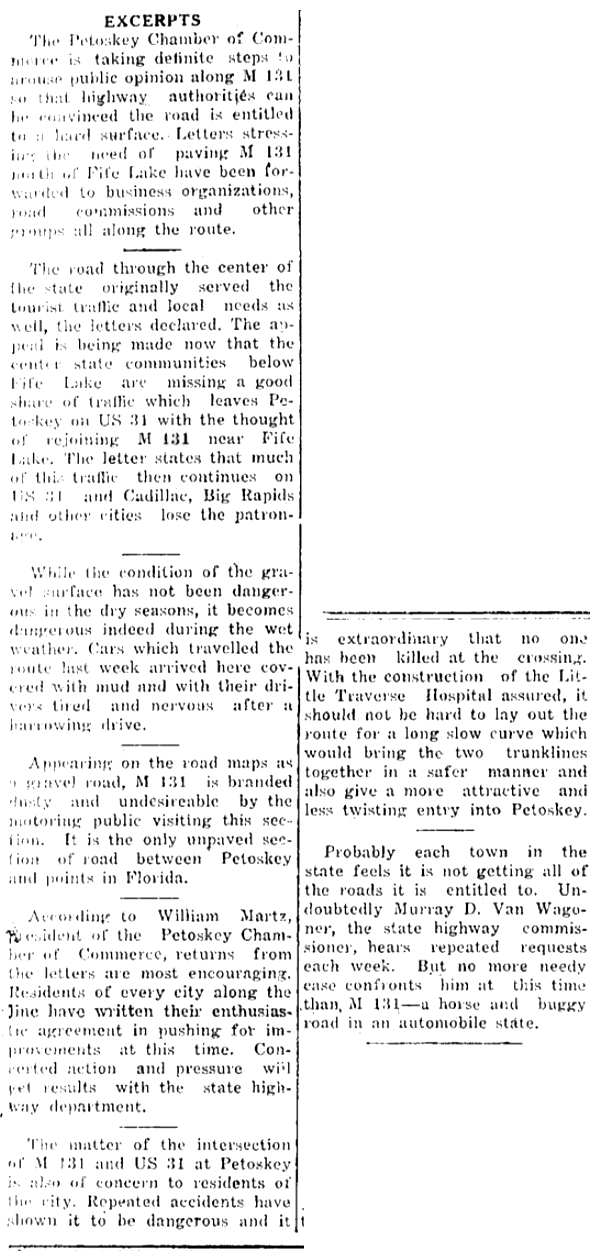
2 June 1938 ~ Emmet County Graphic
|
2 June 1938 ~ Emmet County Graphic
|
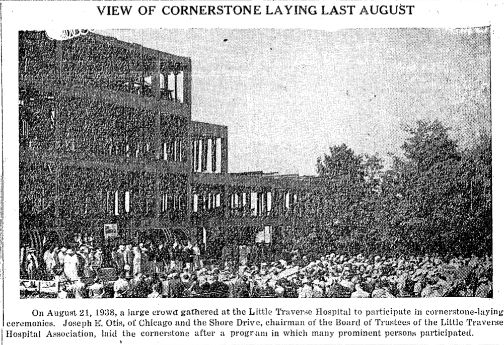
21 August 1938 ~ Petoskey Evening News
17 April 1939 ~ Petoskey Evening News
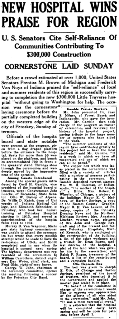
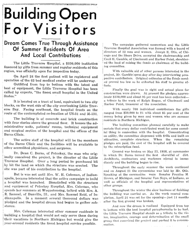
1938 Article Below Left: Dr. Dean C. Burns broke ground for the building of the $300,000.00 Little Traverse Hospital. Master of Ceremonies Cecil Gamble of Cincinnati and Harbor Point thanked the many people of Northern Michigan who had given to the hospital project. He was quoted, "It is our earnest hope that the state highway department can start work on the re-routing of the highway shortly so that it will be complete at least as soon as the hospital. I hope everyone who has any influence in this matter will use it to its fullest extent."
1938 Article Below Right: Three months after the ground was broken for the new hospital, the cornerstone was laid. "Murray D. Van Wagoner, Michigan state highway commissioner, was unable to attend the ceremonies but wrote that every possible attempt would be made to have the re-location of US-31 and M-131 completed and in use when the hospital is opened next spring. The highway department was represented at the ceremonies by William Carrothers, district engineer; Dan Weiss, chief clerk, and Fred Olds, right-of-way buyer."
24 May 1938 ~ Petoskey Evening News
|
25 August 1938 ~ Emmet County Graphic
|
Little Traverse Historical Museum Photo Archive (Undated)
Little Traverse Historical Museum Photo Archive (Undated)
Little Traverse Historical Museum Photo Archive (Undated)
Little Traverse Historical Museum Photo Archive (Undated)
|
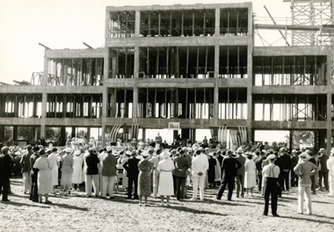
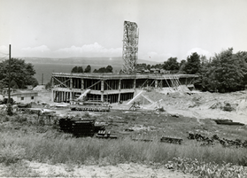
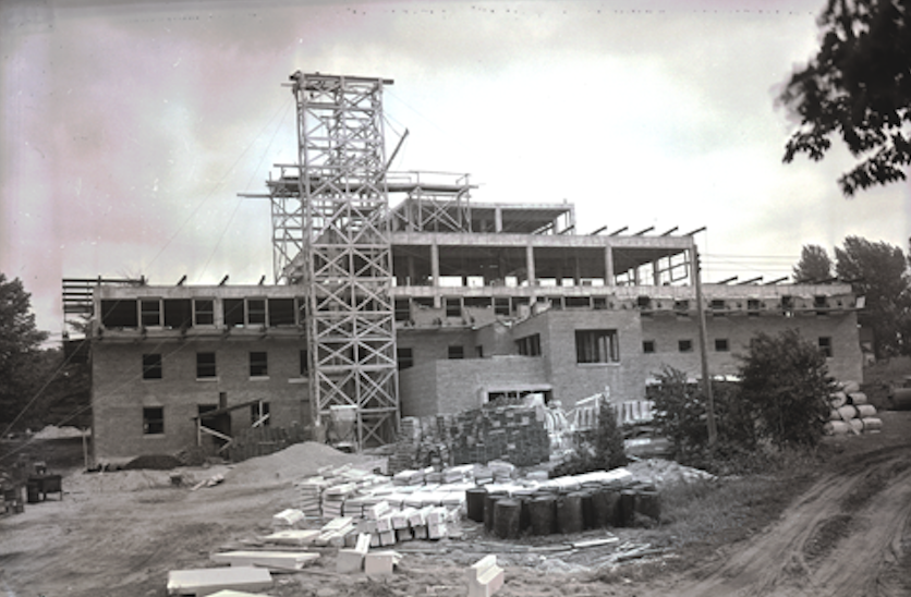
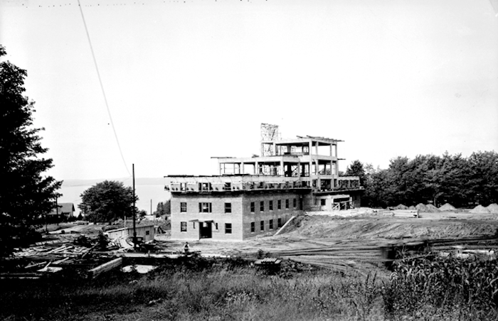
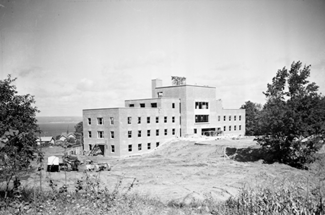
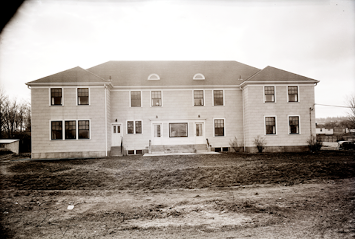
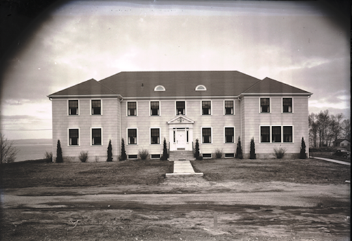
Photos above right and below of the construction of the hospital: For Little Traverse Hospital the ground was broken, a cornerstone was laid, and the construction proceeded, with, as yet, no main hard surfaced entry road into the hospital area; only with assurances from the state that the relocation of US-31 and US-131 would happen. The hospital supporters had encouraged the completion of the hospital construction and the highway construction completing almost simultaneously.
Little Traverse Historical Museum Photo Archive (Undated)
|
Little Traverse Historical Museum Photo Archive (Undated)
|
Little Traverse Historical Museum Photo Archive (Undated)
|

Little Traverse Historical Museum Photo Archive (Undated)
|
Little Traverse Historical Museum Photo Archive (Undated)
|
Little Traverse Historical Museum Photo Archive (Undated)
|
TOP
 A government aerial photo taken 11 July 1938 of Petoskey, Michigan.
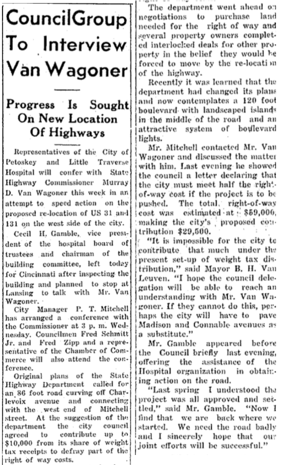
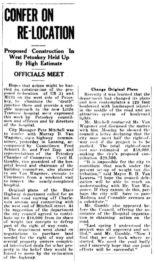
1939 Article Below Left: Cecil Gamble vice president of the hospital's board was traveling from his Harbor Point home to his Cincinnati home, and planned a stop in Lansing to talk with Mr. Van Wagoner of the state highway department. The state had changed plans as to the width of the road to include landscaped islands. The additional width could cost the city more than it could fund for the purchase of right of way. If the new plan could not be funded the city contemplated paving Madison Street and Connable Avenue (already used for road accesses to the location of the new hospital) as a substitute for the extra funding; which would eliminate the rerouting. The 1938 aerial map of Petoskey at right shows a red star marking the dangerous intersection of US-31 and M-131. That red line heads east on Charlevoix Avenue, turns north on Connable Avenue, passing Jackson Street and Monroe Street, to end at Madison Street. To the west of Madison Street was to be the location of the new hospital, pointing out the importance of the re-route desire of the hospital for the main road to proceed directly by the front of the building, leading on into the main street (Mitchell) of Petoskey. In 1938, however, Mitchell Street remained a dead end.
1939 Article Below Right: Cecil H. Gamble, chairman of the hospital building committee, had a Lansing meeting with State HIghway Commissioner Van Wagoner, followed the next day with a visit between Petoskey's City Manager P.T. Mitchell and Van Wagoner. The report from Lansing was that no definite announcement could be made at the time, but future consideration was anticipated.
1939 Article Below Right: Cecil H. Gamble, chairman of the hospital building committee, had a Lansing meeting with State HIghway Commissioner Van Wagoner, followed the next day with a visit between Petoskey's City Manager P.T. Mitchell and Van Wagoner. The report from Lansing was that no definite announcement could be made at the time, but future consideration was anticipated.
21 March 1939 ~ Petoskey Evening News
|
23 March 1939 ~ Emmet County Graphic
|

24 March 1939 ~ Petoskey Evening News
|
|
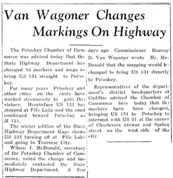
Article Below: The State Highway Department Maps markers had been changed, bringing US-131 (previously M-131) to Petoskey to intersect with US-31 at the corner of Charlevoix Avenue and Spring Street on the west side of city.
15 April 1939 ~ Petoskey Evening News
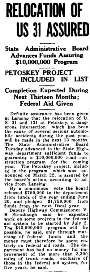
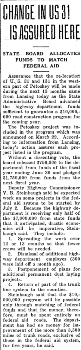
Article Right: Lansing made "assurance that the re-location of US-31 and 131 in the western part of Petoskey will be made during the next 13 months..."
Little Traverse Historical Museum Photo Archive (Undated)
|
31 May 1938 ~ Petoskey Evening News
|
Three Articles/Photo Below: The opening of the new hospital building covered the front page of the 17 April 1939 Petoskey Evening News. The article below left reported that the hospital was awaiting word about "the relocation of US-31 and M-131 entering the city from the south and west. The hospital was located and its drive-ways built to coincide with the plans for the re-location of the highway which called for building a concrete road directly in front of the hospital (see photo above left). From time to time plans were changed and different propositions offered by the highway department but no definite action was taken in Lansing to start the project." The plan that the hospital and the city had sent to Lansing called for the extension of M-131 straight across Charlevoix Avenue with a wide curve circling past the hospital into Madison Street. A reverse curve would take the highway into Mitchell Street. "Until the new road is constructed there will be no hard surface road leading to the hospital." Another article, not shown, but in this same issue stated: "Except for only a few minor items the hospital is completely furnished. Construction of the new US-31 and US-131 into Petoskey from the south and west is the only major item in the hospital plans that is missing as the opening day nears."
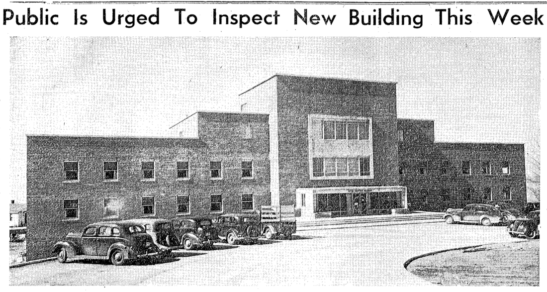
17 April 1939 ~ Petoskey Evening News

17 April 1939 ~ Petoskey Evening News (SAME issue as one announcing the Opening of the Hospital Building)
|
17 April 1939 ~ Petoskey Evening News
|
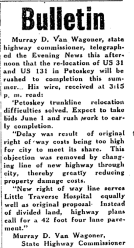
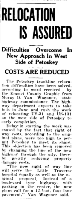
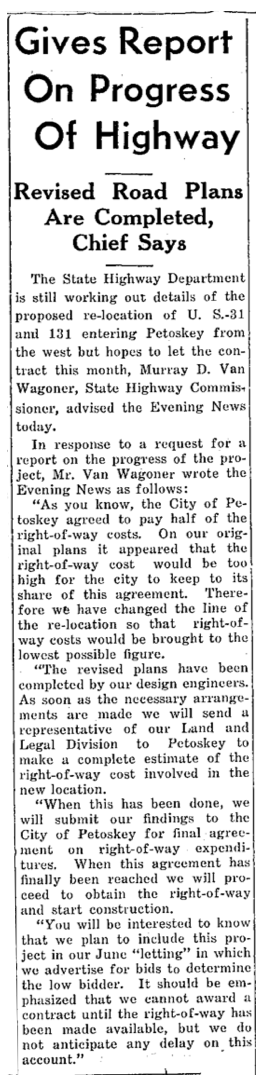
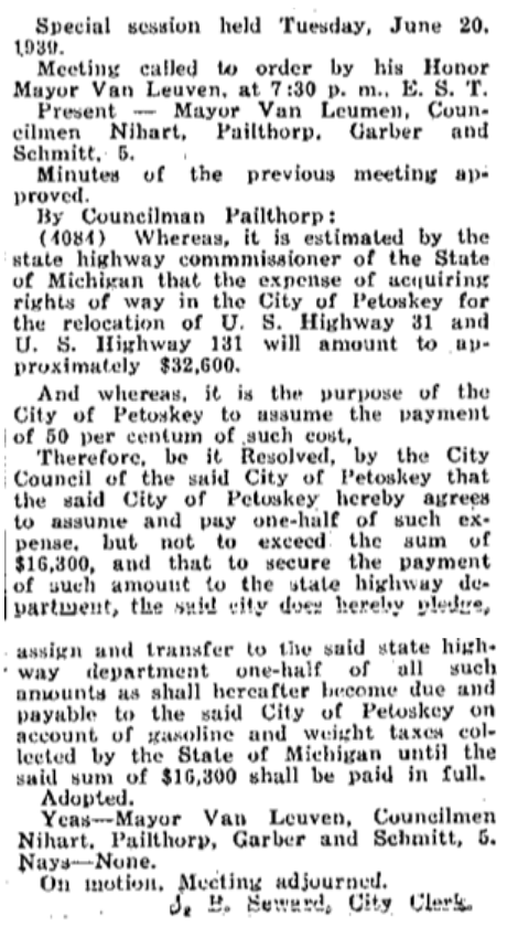
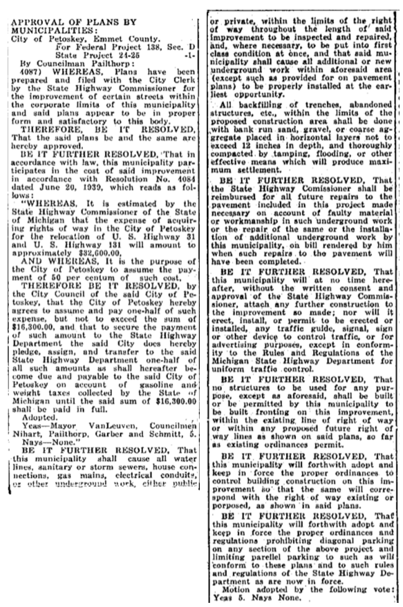
1939 Articles and Map Below: "Petoskey trunkline relocation difficulties have been solved. Expect to take bids June 1 and rush work to early completion... New right of way line serves Little Traverse Hospital equally well as original proposal. Instead of divided land, highway plans call for a 42 foot four lane pavement." The change of right of way would lower the cost due to change of road width and would be more acceptable to the city. In June a Special Session of the City Council unanimously approved what was "estimated by the state highway commissioner of the State of Michigan that the expense of acquiring rights of way in the City of Petoskey for the relocation of U.S. Highway 31 and U.S. Highway 131 will amount to approximately $32,600.00" and, for the city to pay half that expense. The new design (see map drawing below) would relocate US-31 and 131 from their present junction at Charlevoix and Spring streets on to Mitchell Street. With wide sweeping curves the roadway would pass the Little Traverse Hospital, follow Madison Avenue and turn gently to give a straight entrance into Mitchell Street.

8 November 1939 ~ Petoskey Evening News
19 April 1939 ~ Petoskey Evening News
|
20 April 1939 ~ Emmet County Graphic
|
31 May 1939 ~ Petoskey Evening News
|
24 June 1939 ~ Petoskey Evening News
|

6 July 1939 ~ Petoskey Evening News
|
15 July 1939 ~ Petoskey Evening News
|
20 July 1939 ~ Emmet County Graphic
|
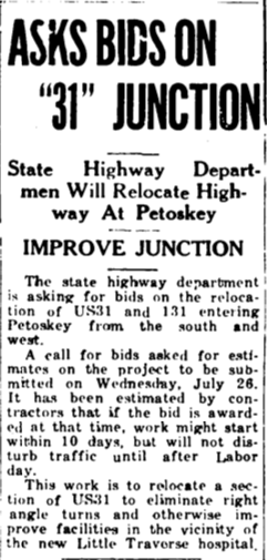
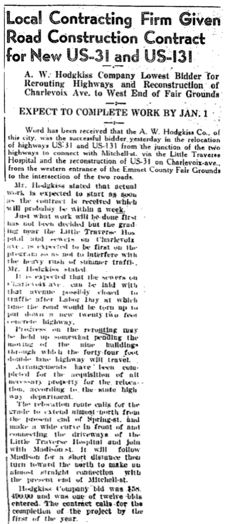
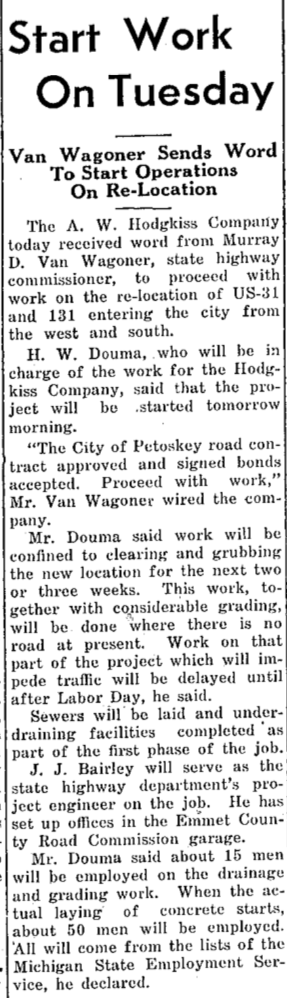
1939 Articles Below: Arrangements have been made to acquire all necessary property for the re-location. Local contracting firm A.W. Hodgkiss Company was given the contract for New US-31 and US-131. H.W. Douma, in charge of the company's work, would begin with clearing and grubbing where no road then existed. Infrastructure would be in the first phase of the project. "When the actual laying of concrete starts, about 50 men will be employed. All will come from the lists of the Michigan State Employment Service."
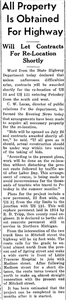
20 July 1939 ~ Petoskey Evening News
|
27 July 1939 ~ Northern Michigan Review
|
14 August 1939 ~ Petoskey Evening News
7 October 1939 ~ Petoskey Evening News
|
8 May 1941 ~ Northern Michigan Review
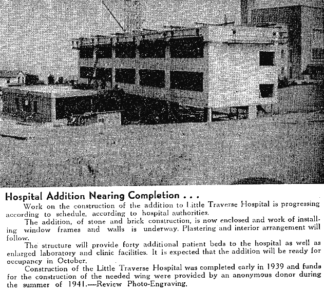
Photo/Text Below: By 1942 Little Traverse Hospital already was beginning a "new wing" on the facility.
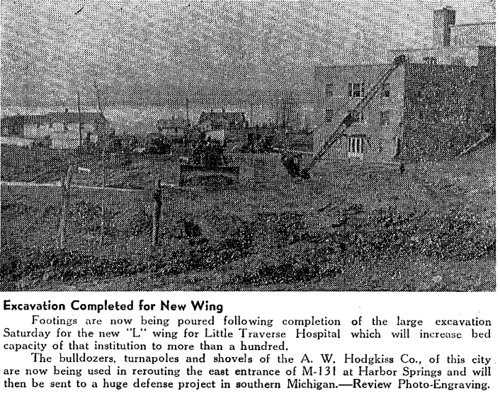
9 April 1942 ~ Northern Michigan Review
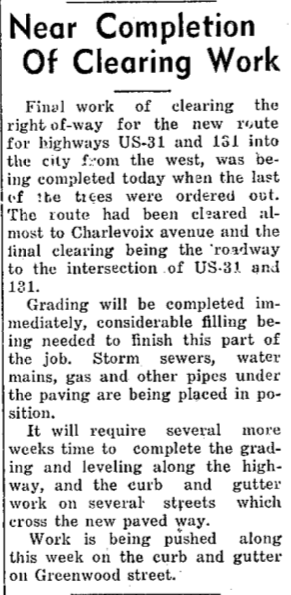
~ Clearing the Right-of-Way ~
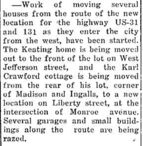
In early 2020 a 94 year lifelong Petoskey resident, Lorraine Washburne, told of having lived on Liberty Street at the time of the US-31 and 131 relocation project. Her family's home was right at the dead end of Mitchell Street, so the family's house was moved over to Jefferson Street. She told that at the relocation time, the hospital, with its donors, was the biggest motivator for the extension of Mitchell Street in the proposed location past the hospital, drastically changing the community and business Life for the West Side of Petoskey. Hers was only one story of upheaval of homes at that time, as the 1939 articles below testify. UPDATE: Sadly, Lorraine Washburne has passed away on 1 September 2020. She and her local history stories, not recorded, will be missed.
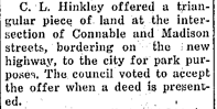
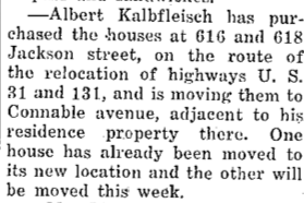
The state’s purchasing of right-of-way properties for the the roadway extension of Mitchell Street provided funding to residents for various once-in-a-lifetime occasions; like the story of one Petoskey family's R-O-W funds providing the opportunity to attend the 1939 New York World’s Fair… timing was perfect. The World’s Fair theme was the “World of Tomorrow” reminiscent of Petoskey's new roadway extension contributing to the future of Petoskey and its new hospital’s "World of Tomorrow"… still progressing in 2021. A Triangular piece of land at Connable and Madison intersection was accepted by the city council for park purposes.
15 August 1939 ~ Petoskey Evening News
8 September 1939 ~ Petoskey Evening News
|
13 September 1939 ~ Petoskey Evening News
|
21 September 1939 ~ Petoskey Evening News
|
Photo Below: The Potts Laundry Dry Cleaners (noted on sign in photo) was located on the corner of Liberty Street and the dead end of Mitchell Street. While the dead end is clearly evident with state highway posted sign apparent, It appears the relocation work of the construction had begun.
Little Traverse Historical Society Photo Collection (Undated)
1939 Article Below:
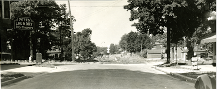
"Actual pouring of concrete on the new paving of the relocation was started yesterday noon."
"Actual pouring of concrete on the new paving of the relocation was started yesterday noon."
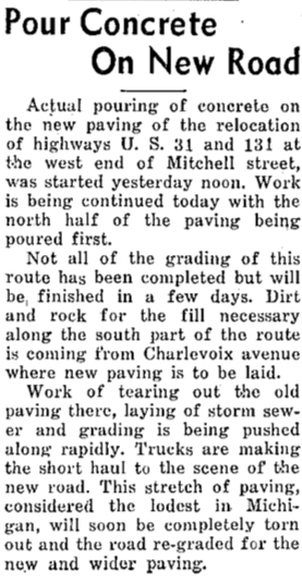
23 September 1939 ~ Petoskey News Review
This hard to read/view clipping from the 1939 newspaper below asks... with the extension of US-131,
rather than the ninety degree junction, if this happening might be the "Last Accident at Old Junction?"
rather than the ninety degree junction, if this happening might be the "Last Accident at Old Junction?"
Transcribed Text Below Photo: “Soo Trucker Overturns Semi… Neighbors Get Vegetables Last Week
“Failing to negotiate the right-angle turn at the junction of US-31 and US-131 when entering the city from the south last Thursday afternoon, the semi carrying a load of fruit and vegetables broke away from the tractor, splitting the under timbers and overturned on Wimpy’s corner. Albert Vogel, owner and operator of the vehicle, was unable to check the speed of the truck with his brakes sufficient to round the corner, local officers reported.”
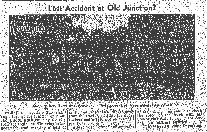
28 September 1939 ~ Northern Michigan Review
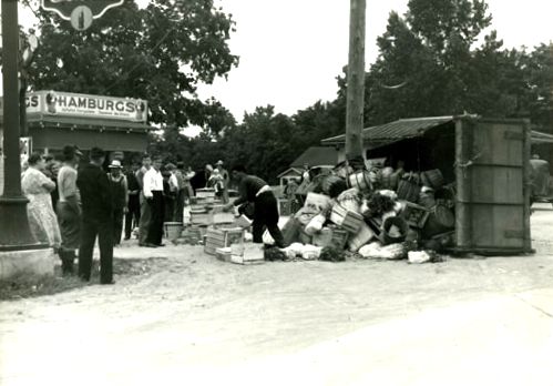
Little Traverse Historical Museum Photo Archive
In Jim Doherty's 14 July 1982 "Looking 'em Over" Petoskey News Review article below, Jim reminisced about Wimpy's having been located on one of the many 90 degree corners to reach Mitchell Street, before the elimination of the Mitchell Street Dead End.
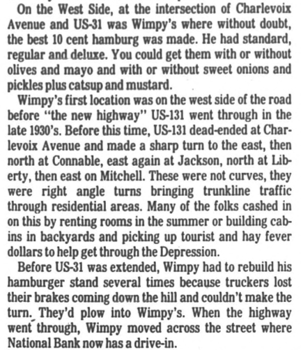
14 July 1982 ~ Petoskey News Review
1939 Article Below Left: "Provisions will be made tomorrow for the use of Madison Street to reach Little Traverse Hospital. A temporary crossing over the new pavement will be made, it was announced, making it unnecessary to use Jefferson Street to reach the hospital."
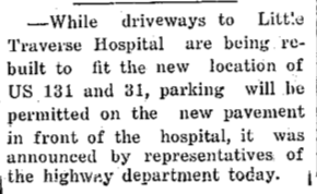
1939 Article Below Center: Pavement was completed from the US-31 and US-131 junction to the west end of Mitchell Street. Paving machinery had been moved to a point on US-31 near the Emmet County fair grounds." Concrete, along with curbs and gutters, were to be constructed on Charlevoix Avenue from the fairground to the junction. Driveways to Little Traverse Hospital were being built to fit the new location of US-131 and US-31, while parking was permitted on the new pavement in front of the hospital.
Other articles below show that businesses were positioning themselves for the new highway relocation and the business possibilities.
Other articles below show that businesses were positioning themselves for the new highway relocation and the business possibilities.

3 October 1938

6 October 1939 ~ Petoskey Evening News

7 October 1939 ~ Petoskey Evening News
|
9 October 1939 ~ Petoskey Evening News
14 October 1939 ~ Petoskey Evening News
25 October 1939 ~ Petoskey Evening News
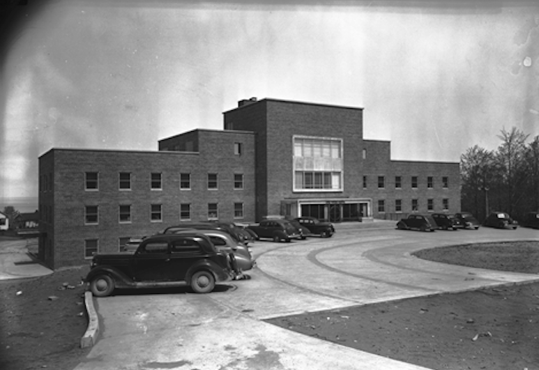
Article Above and Photo Below Left illustrate that hospital driveways needed to be built to fit the new location of US-131 and US-31.
|
Little Traverse Historical Museum Photo Archive (Undated)
|
Little Traverse Historical Museum Photo Archive (Undated)
|
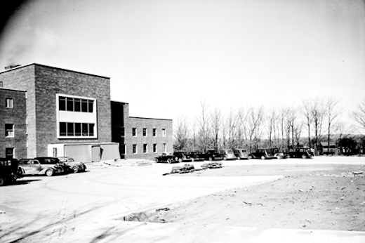
Article Below and Photo Above Right: The article below explained the construction of the relocated highway as it swung past the hospital. The photo above right showed the traffic flowing smoothly on new concrete past the new hospital.

8 November 1939 ~ Petoskey Evening News

8 November 1939 ~ Petoskey Evening News photo accompanied article at right...
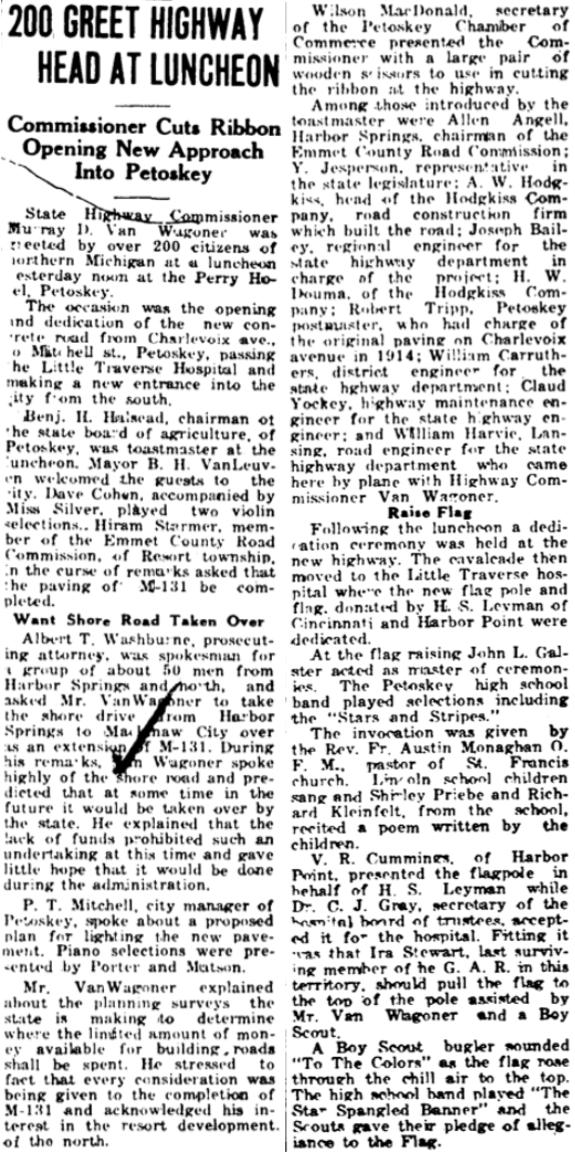
Photo Above: Murray D. Van Wagoner was the state highway commissioner who worked through the M-131 to US-131 project with its relocation through Downtown Petoskey.
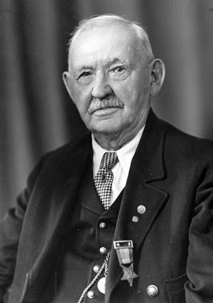
Greenwood Photo Archive Collection ~ Ira Stewart
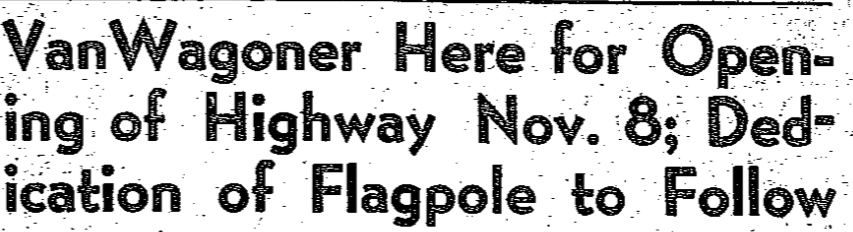
Photo Above: After the road opening ceremonies, the High School Band led a parade down the new highway to little Traverse Hospital where a flagpole was dedicated and Ira "Dad" Stewart (above), last surviving member of the G.A.R. in this area, raised the Stars and Stripes. Ira Stewart passed away the next year... 1940.
|
8 November 1939 ~ Petoskey Evening News two articles with left column article continued in far right column...
2 November 1939 ~ Northern Michigan Review
Little Traverse Historical Museum Photo Archive (Undated)
|
8 November 1939 ~ Petoskey Evening News article continued from far left column...
|
1939 Article Below:
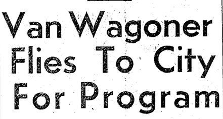
Murray D. "Pat" Van Wagoner expressed pleasure and thanks at the program for the New Road.
Murray D. "Pat" Van Wagoner expressed pleasure and thanks at the program for the New Road.
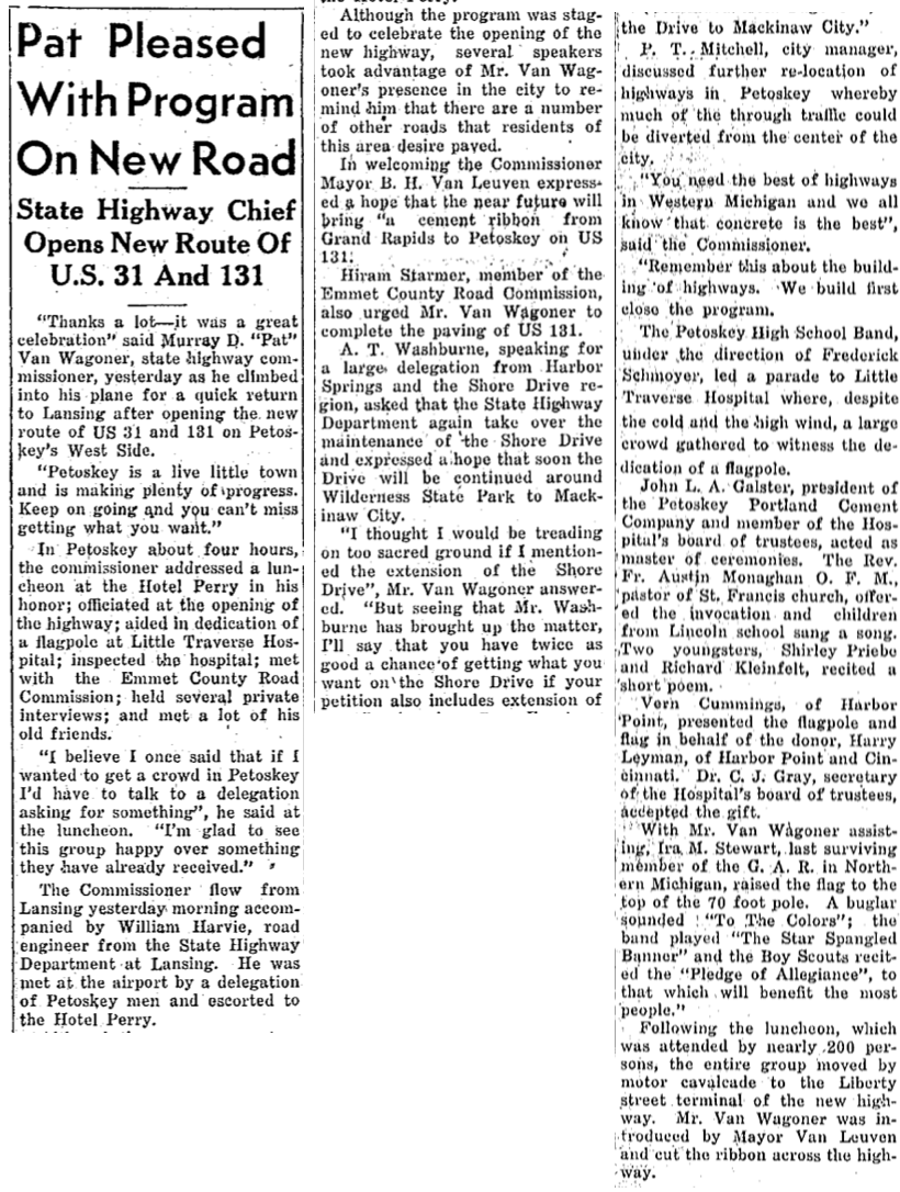
9 November 1939 ~ Petoskey Evening News
9 November 1939 ~ Emmet County Graphic
1939 Drawing and Article Below: Only a couple of weeks after the opening of the relocation of US-31 and US-131 directly past the new hospital, the nearby housing quarters for Women Employees of Little Traverse Hospital was announced as completed. "The two-story dwelling located on the hospital property at old Madison, north side, was built...."
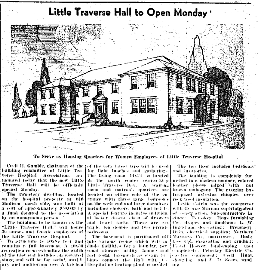
23 November 1939 ~ Northern Michigan Review
|
Photo Below Left:
The nurses' dwelling from the back PRE-landscaping. |
Photo Below Right:
The nurses' dwelling from the front POST-landscaping. |
Little Traverse Historical Museum Photo Archive (Undated)
|
Little Traverse Historical Museum Photo Archive (Undated)
|
|
Photo Below Left: The nurses' dwelling was photographed from the back,
making the new Little Traverse Hospital visible in the background. |
Photo Below Right: The nurses' dwelling was photographed from the front,
with the new Little Traverse Hospital center front. |
Photo Below: This is the building in 2020 that is in the same location
as the Nurses' Dwelling in years gone by
and seen in the two photos above, and two photos below this photo.
25 May 2012

Little Traverse Historical Museum Photo Archive (Undated)
|
|
6 August 1942 ~ Northern Michigan Review
The 1942 September updated Sanborn Map below shows the relocated US-31 and US-131 sweeping curved route
meeting up with the previous dead end of Mitchell Street.
The hospital (red dot) was also drawn into the map,
as well as the new nurses' dwelling building (red dot) on the west side of Madison Street.
Notice that the vacant created (from right-of-way) triangular properties on the western end of Madison Street,
owned by the city,
still in 2022 remain city properties, which have been used for public uses;
1) Triangle Park~the people's voices (nurses' strike) and 2) Veterans Park in the past (WWII).

1942 September updated Sanborn Map
2001 Photo Below:
The relocated US-31 and US-131 sweeping curved route meeting up with the long ago "dead end of Mitchell Street" was being reconstructed to feature a divided roadway in front of the hospital
to help accommodate the very busy roadway.
The relocated US-31 and US-131 sweeping curved route meeting up with the long ago "dead end of Mitchell Street" was being reconstructed to feature a divided roadway in front of the hospital
to help accommodate the very busy roadway.
Greenwood Photo Archive Collection from Petoskey Newspaper (2001)
Greenwood Photo Archive Collection from Petoskey Newspaper (2001)
Two Photos Below: Posted on this Northern Mich~Mash Preserve web site
only by permission from
remarkable photographer and videographer Charles Dawley of Up North Imaging.
only by permission from
remarkable photographer and videographer Charles Dawley of Up North Imaging.
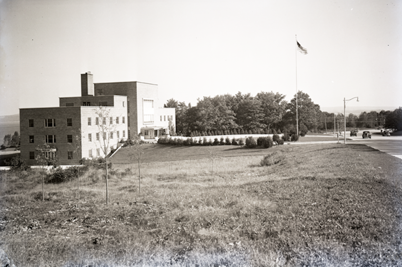
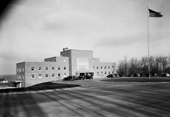
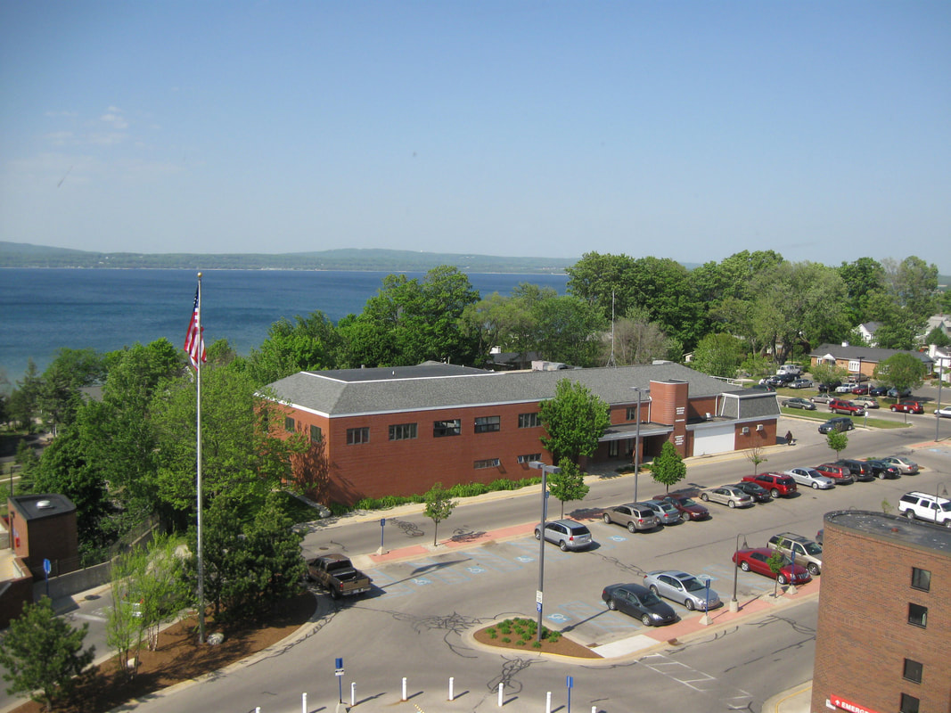
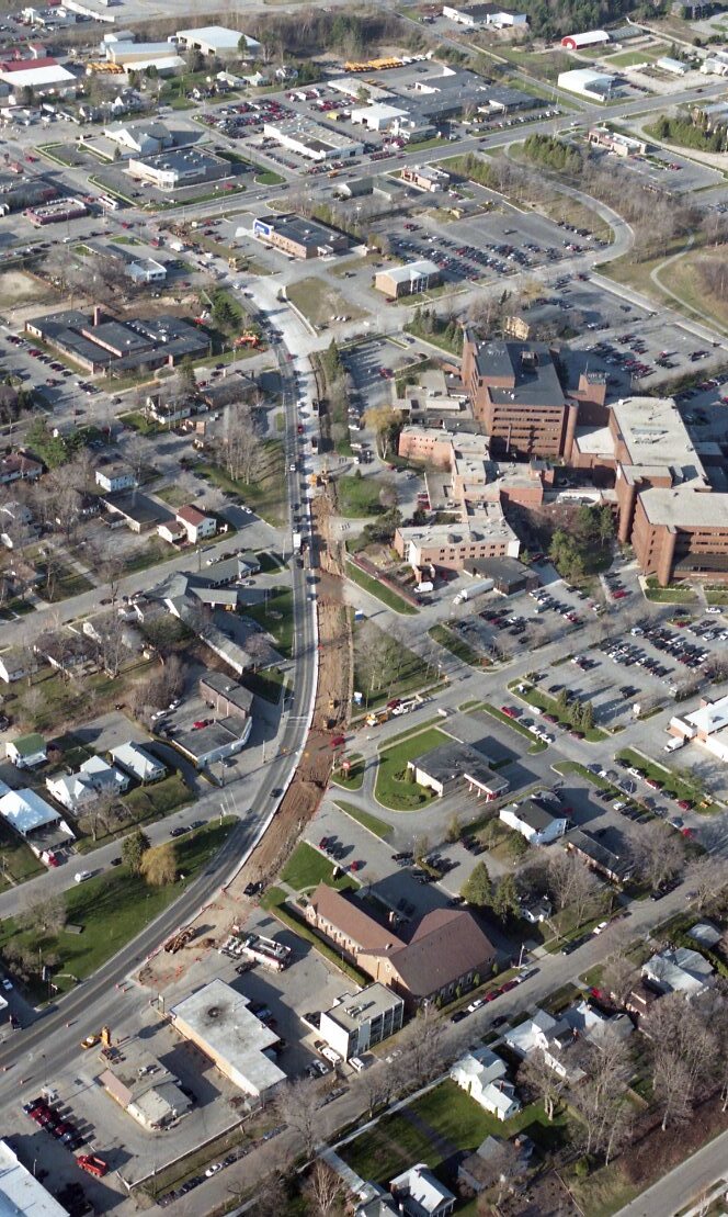
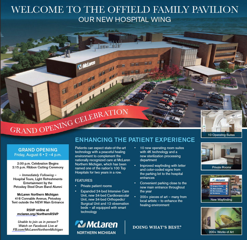
Photo Below: US-131 (looking southerly direction) coming down Spring Street hill meets at the busy junction with US-31 coming to Petoskey from Charlevoix Avenue. The hospital chose this location and was building its original building the same year, 1939, that the relocation of the two trunklines were extended into the city in a sweeping curve. The hospital always had desired the main road to swing closely by the hospital's building. The roadway design and the hospital's location have been retained over the years with multiple additions to the main building as witnessed in the below photo. The hospital in 2020 is in the midst of over a $100 million addition.
23 April 2020 ~ Charles Dawley (permission to post only on this Northern Mich~Mash Preserve web site).
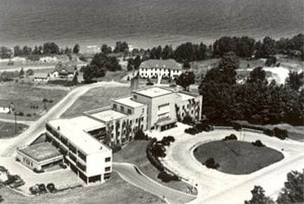
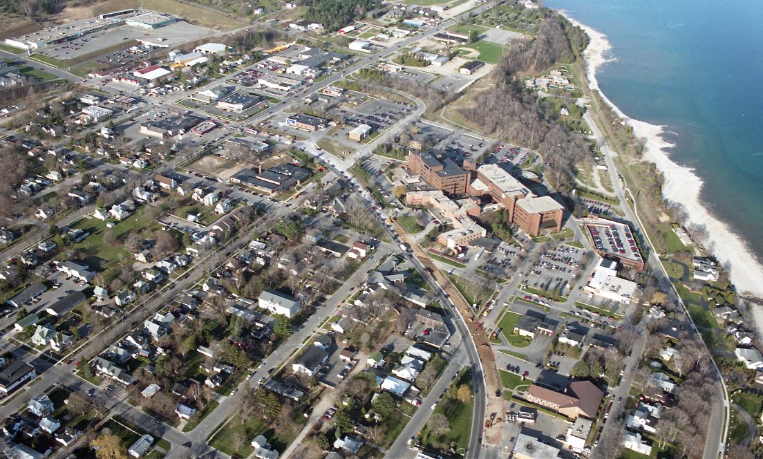
Photo Below: Originally Little Traverse Hospital, but after several name changes with ownership changes, the name is McLaren Northern Michigan in 2020. The far left straight roadway is West Mitchell Street extending past Liberty Street, past the Mitchell Street Bridge, heading through Downtown Petoskey as the main street, and finally, traveling farther out into the countryside on East Mitchell Road. Mitchell Street is no longer a Dead End!
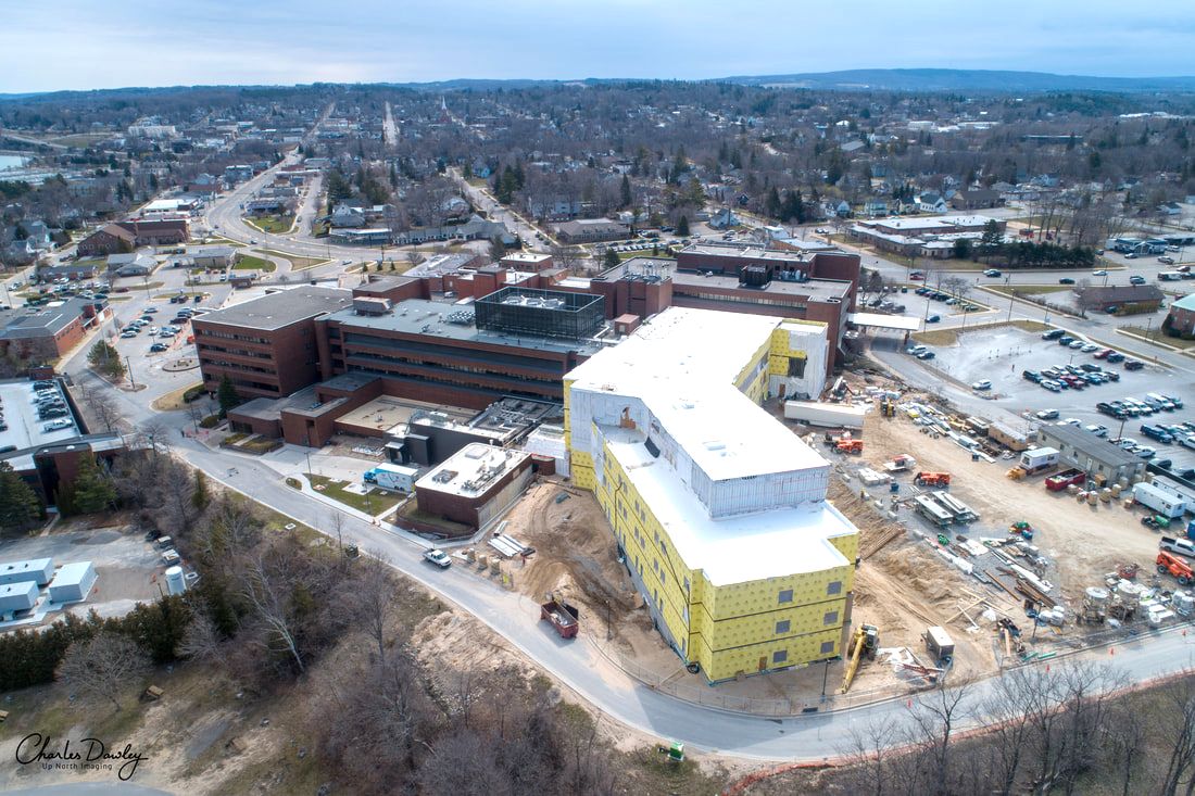
23 April 2020 ~ Charles Dawley (permission to post only on this Northern Mich~Mash Preserve web site).
Mitchell Street ~ No Longer A Dead End!
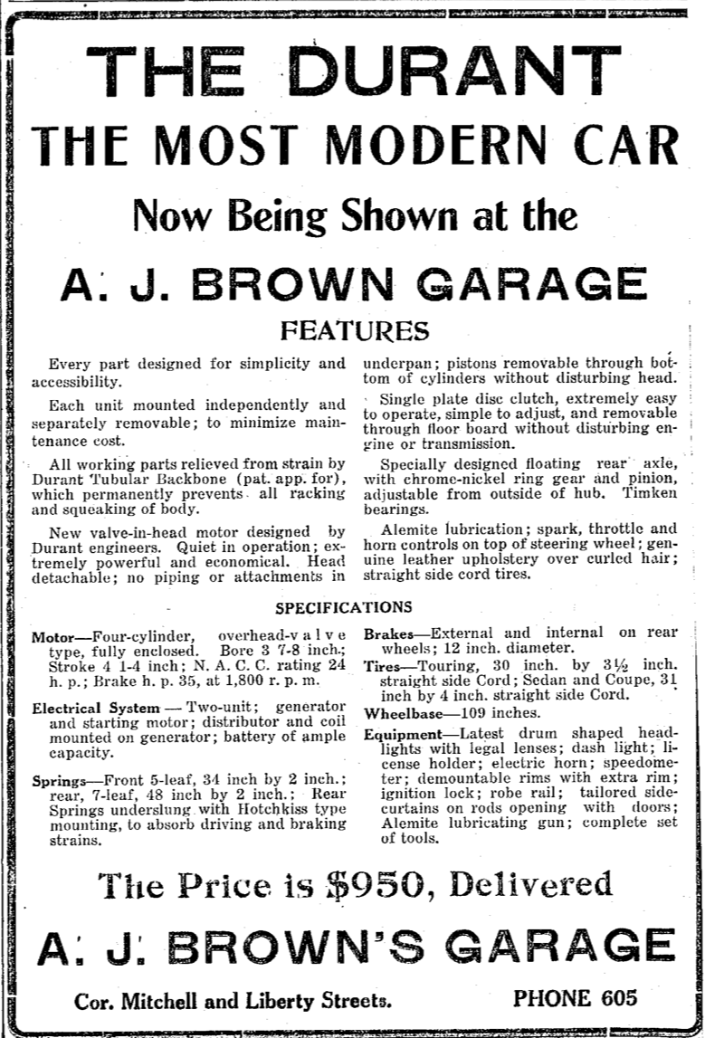
5 August 2021 ~ Petoskey News Review Advertisement
1954 Article Below: Talk of rerouting US 131 to by-pass Petoskey.
Click HERE for more information on this same web site about the Petoskey By Pass (Sunset Boulevard)
Click HERE for more information on this same web site about the Petoskey By Pass (Sunset Boulevard)
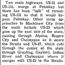
7 May 1954 ~ Petoskey News Review & Northern Michigan Review
Several Maps on this web page:
Credited to Sanborn Fire Insurance Maps from Petoskey, Emmet County, Michigan.
Sanborn Map Company, Retrieved from the Library of Congress.
Credited to Sanborn Fire Insurance Maps from Petoskey, Emmet County, Michigan.
Sanborn Map Company, Retrieved from the Library of Congress.
