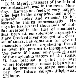
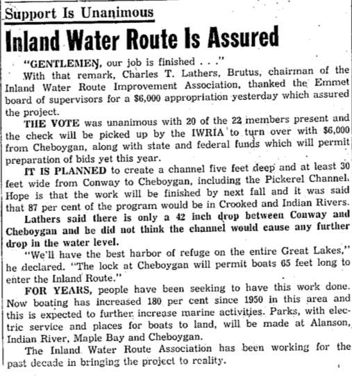
Northern Mich~Mash Preserve
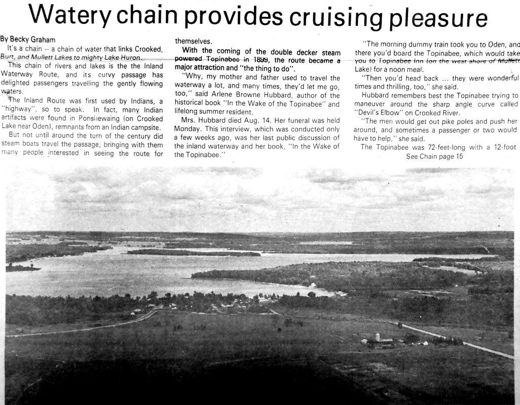
~ CROOKED RIVER AND LOCK ~
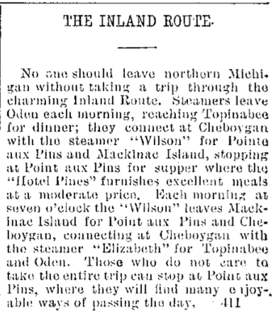
"Inland Route*"
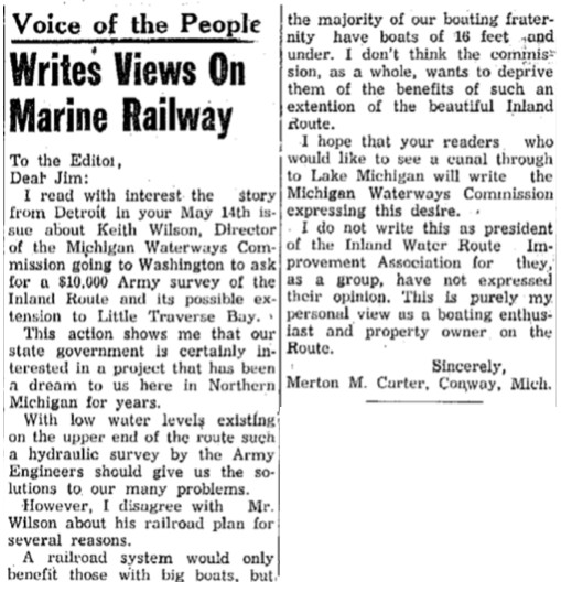
~ PUBLICLY SPEAKING ~
The design and compilation of the text and photos on this site are copyrighted 2017.
Most posted items will enlarge by "clicking" on them.
"Clicking" on some color highlighted words may access additional information.
Most posted items will enlarge by "clicking" on them.
"Clicking" on some color highlighted words may access additional information.
Please do not copy the photos on this site, many of which have been submitted by private individuals...
just come back and visit the site often to view the photos.
just come back and visit the site often to view the photos.
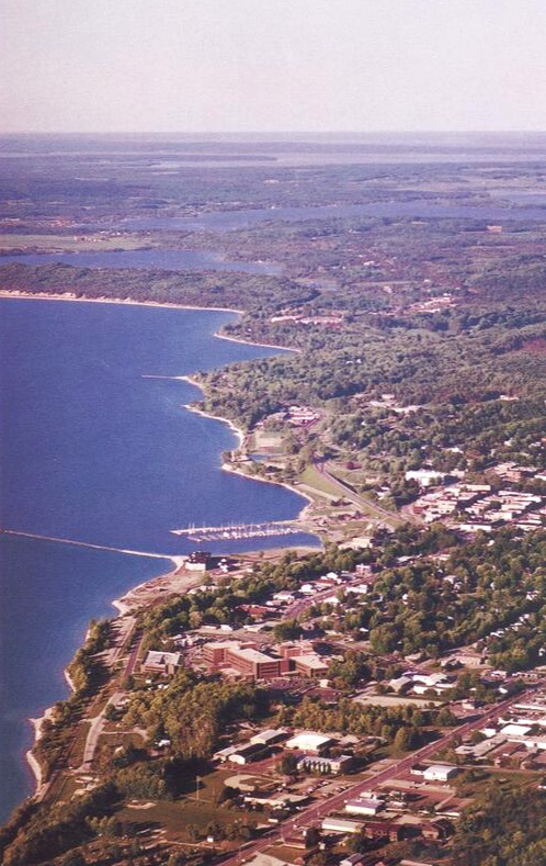
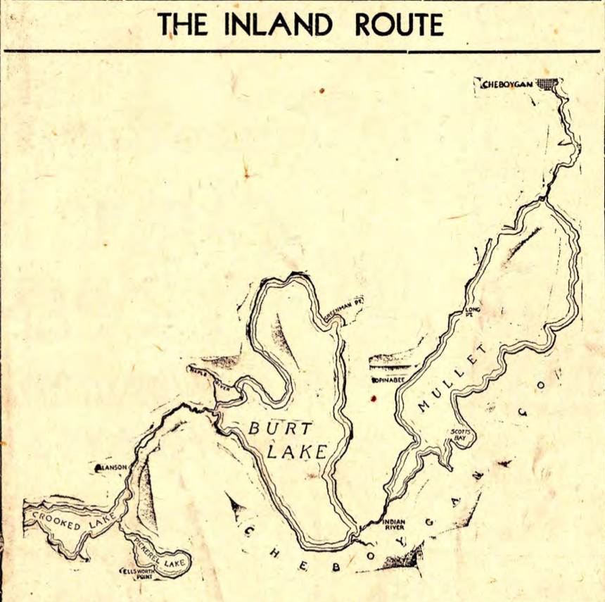
*A remarkable feature of the feeder waters of the Inland Route is that those feeders rise within a very short distance of Little Traverse Bay, but NOT from Little Traverse Bay. The discharge does flow east and north for more than 40 miles to empty into Lake Huron at Cheboygan, Michigan.
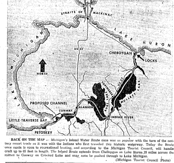
Map SECTION Below of
Emmet, Cheboygan and Presque Isle Counties including
The Straits of Mackinac and Island of Mackinac
and showing the Inland Route through the Chain of Lakes
from Petoskey to Cheboygan & Mackinac
View the entire map at Little Traverse Historical Society Collections by clicking HERE.
Emmet, Cheboygan and Presque Isle Counties including
The Straits of Mackinac and Island of Mackinac
and showing the Inland Route through the Chain of Lakes
from Petoskey to Cheboygan & Mackinac
View the entire map at Little Traverse Historical Society Collections by clicking HERE.
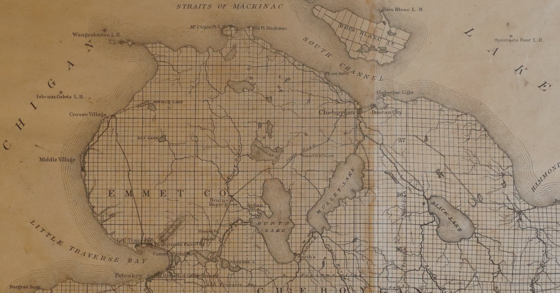
1879 ~ Little Traverse Historical Society Map Collection
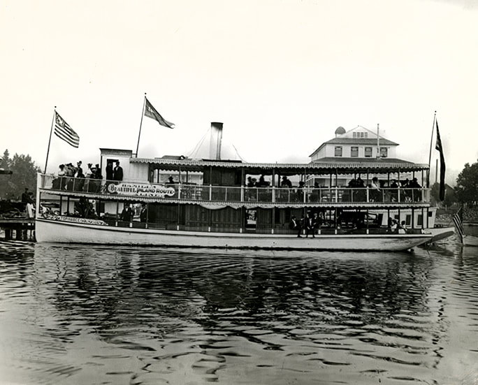
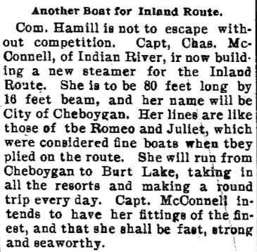
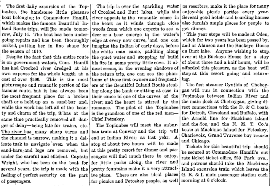
Referring to Drawing Below: “The Steamer Topinabee was built in 1899 in Charlevoix and purchased by Commodore A.L. Hamill whose office was lcaated in downtown Petoksey. He was a quirky-but-successful businessman with unique marketing plans. One of his schemes was printed in the Petoskey Herald as follows: ‘A.L. Hamill has found another use for a bicycle and every time he rides his wheel he will leave behind him ‘footprints on the sands of time’ in the shape of an advertisement which reads: ’Hamill, the Ticket Broker, Petoskey.’”
~ "11 August 2005, Reflections" supplement to the Petoskey News Review
~ "11 August 2005, Reflections" supplement to the Petoskey News Review
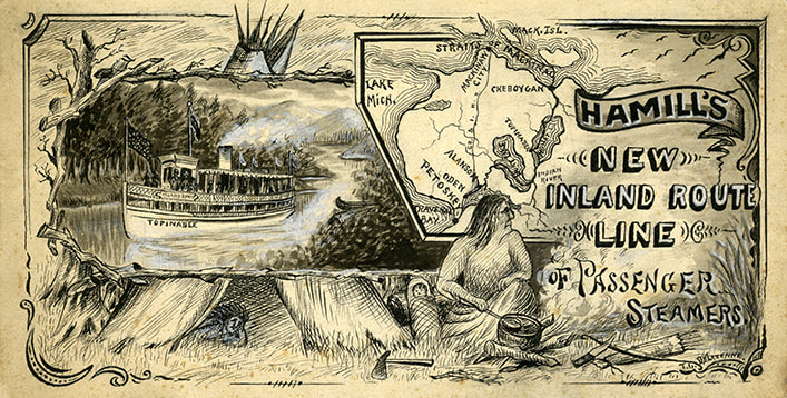
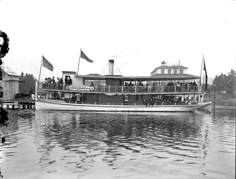
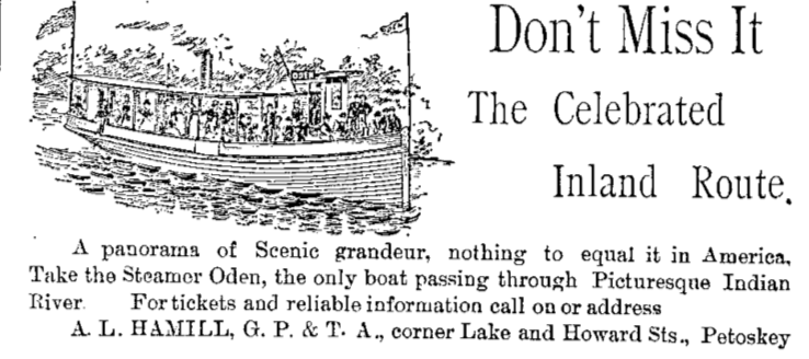
Hamill's Advertisement for the NEW Inland Route Line of Passenger Steamers
3 January 1879 ~ Emmet County Democrat
1890
~ Crooked Lake John Hastings Inland Water Way Landing ~
"Glenn L." AND "Oden"
~ Crooked Lake John Hastings Inland Water Way Landing ~
"Glenn L." AND "Oden"
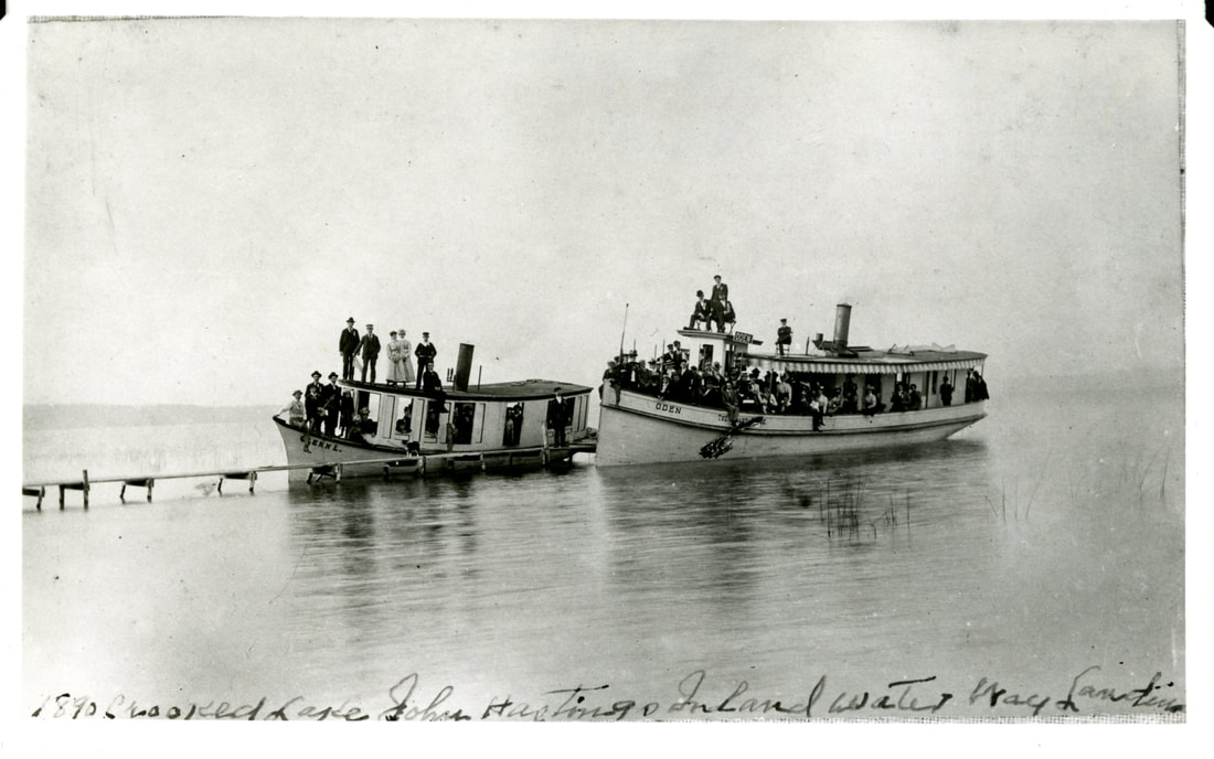
Album of Allan McCune in the Little Traverse Historical Society Museum
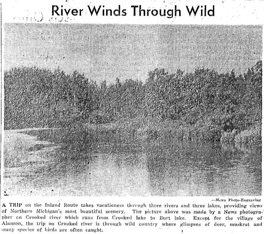
Aerial Postcard Below: The many waters of the Inland Waterway
beginning with Crooked Lake heading over to Lake Huron are obvious.
beginning with Crooked Lake heading over to Lake Huron are obvious.
Greenwood Photo Archive Collection from Postcards "Maves" (Undated)
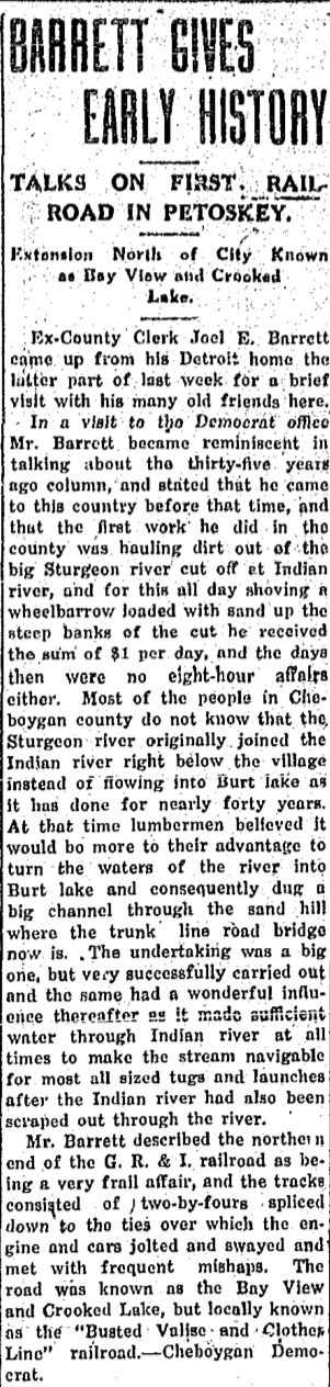
6 September 1919 ~ Petoskey Evening News
|
The 1919 article at the left told that In about 1879, "the Sturgeon River originally joined the Indian River right below the village instead of flowing into Burt Lake as it has done for nearly forty years. At that time lumbermen believed it would be more to their advantage to turn the waters of the river into Burt Lake and consequently dug a big channel through the sand hill where the trunk line road bridge now is. The undertaking was a big one, but very successfully carried out and the same had a wonderful influence thereafter as it made sufficient water through Indian River at all times to make the stream navigable for most all size tugs and launches after the Indian River had also been scraped out through the river."
5 September 1894 ~ The Daily Record
10 July 1895 ~ The Petoskey Record with a Cheboygan Tribune by-line
|
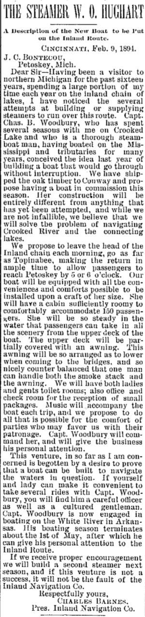
14 February 1894 ~ The Petoskey Record
|
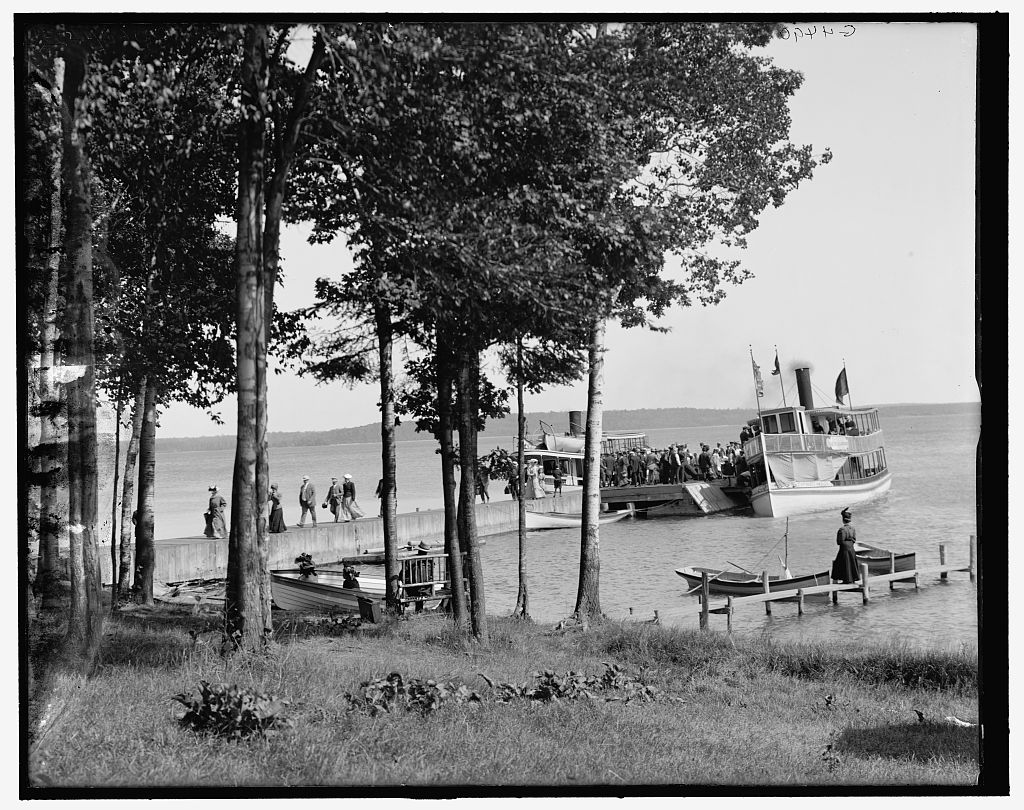
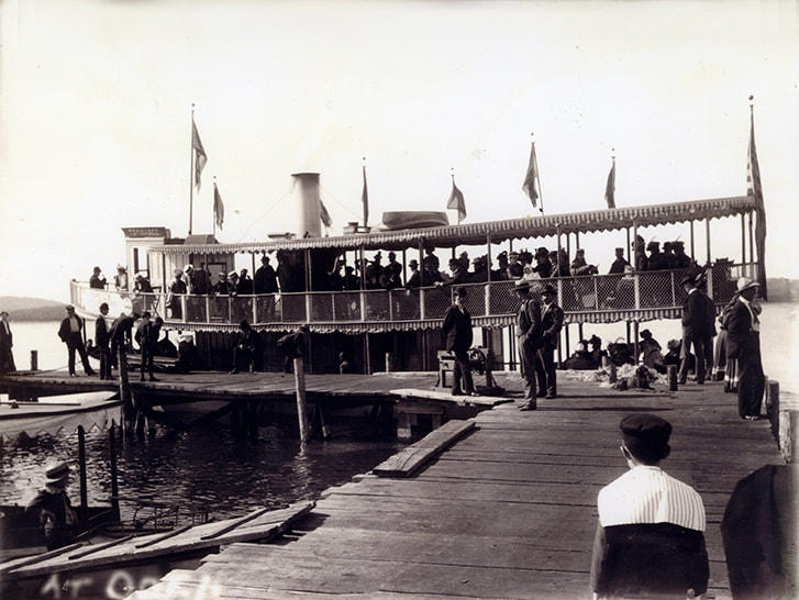
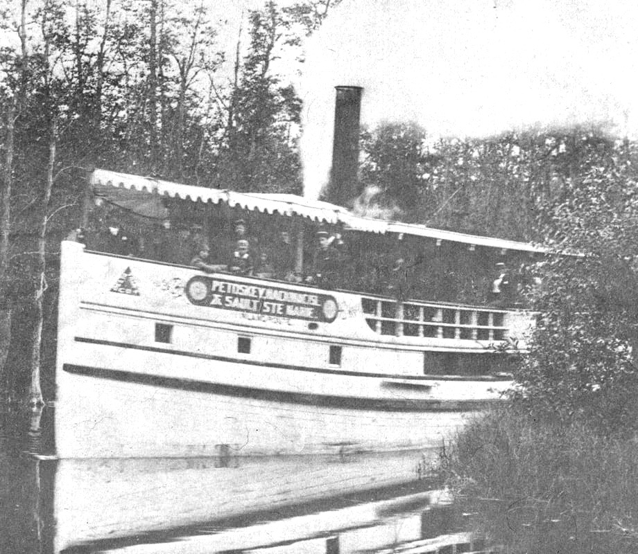
Hamill's Boat Landing ~ Library of Congress, Detroit Publishing Company Collection
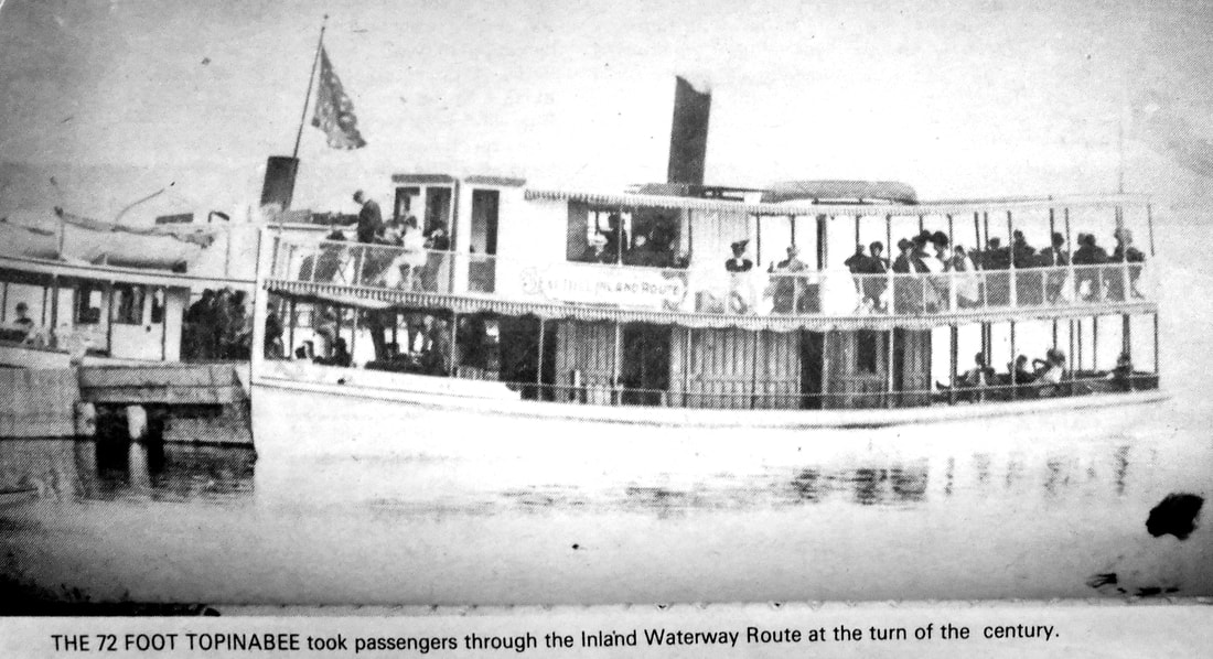
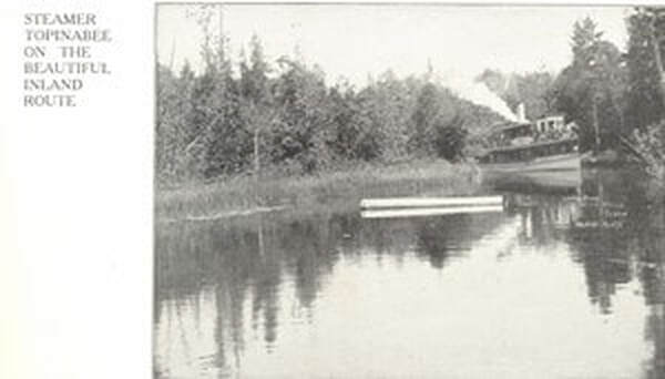
Little Traverse Historical Society Photo Collection ~ Topinabee (Undated)
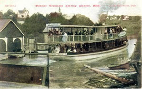
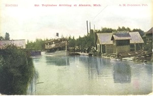
Greenwood Photo Archive Collection ~ Postcard of Steamer Topinabeee Leaving Alanson, Mich.
|
Steamers Romeo AND Juliet plied "The Inland Route"
1895
1895
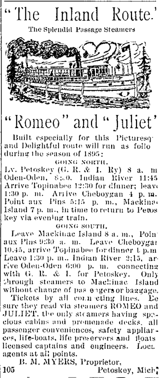
21 July 1895 ~ The Daily Record
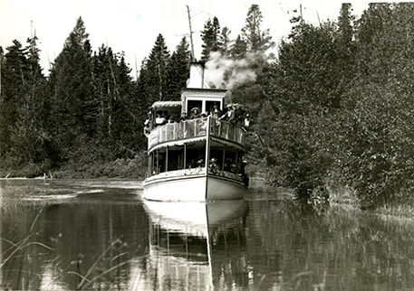
Oden on the Inland Waterway
Little Traverse Historical Society Photo Collection
|
Little Traverse Historical Society Photo Collection
|
Undated clipping from OLD personal scrapbook in Michigan Room of Petoskey District Library
12 May 1958 ~ Petoskey News Review
Greenwood Photo Archive Collection from Petoskey News Review (12 May 1958)
Undated clipping from OLD personal scrapbook in Michigan Room of Petoskey District Library... continuation of the article was not included
Christening and Launching of Hamill's "Tompinabee"
1899
1899
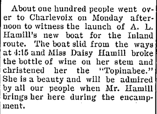
7 June 1899 ~ The Petoskey Record
Little Traverse Historical Society Photo Collection
|
2 July 1902 ~ The Petoskey Record
|
Little Traverse Historical Society Photo Collection (Undated)
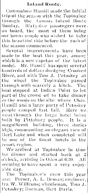
Hamill's NEW Inland Route Topinabee ~ Little Traverse Historical Society Photo Collection

6 February 1907 ~ The Petoskey Record article continued right column...
|
6 February 1907 ~ The Petoskey Record article continued from right column...
Photo Below:
Models of the Romeo, Juliet, and Topinabee 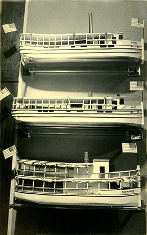
Little Traverse Historical Society Photo Collection (Undated)
|
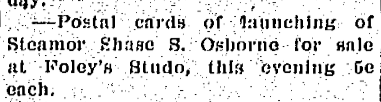
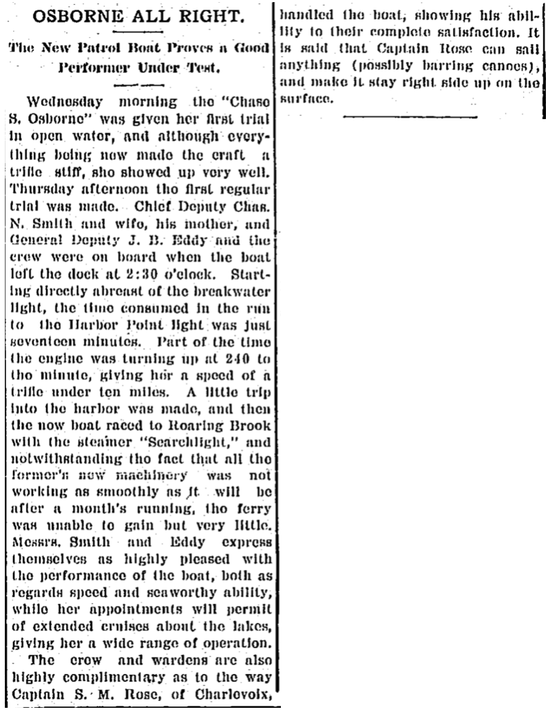
1908 Articles Below: The Steamer Osborne which had been built for passenger service on the Inland Route for Hamill's summer line was recently purchased by the state government to be used as a patrol boat to prevent illegal fishing on Lake Michigan.

24 June 1908 ~ The Petoskey Record

27 June 1908 ~ Petosksey Evening News
27 June 1908 ~ Petoskey Evening News
|
3 July 1908 ~ Petoskey Evening News
|
23 July 1908 ~ The Daily Resorter & Petoskey Evening News
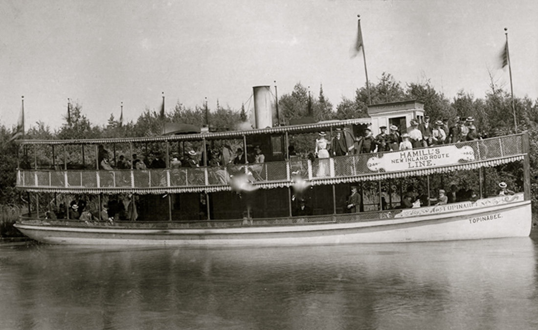
Photo Below: Loading up the Topinabee...
Little Traverse Historical Society Photo Collection
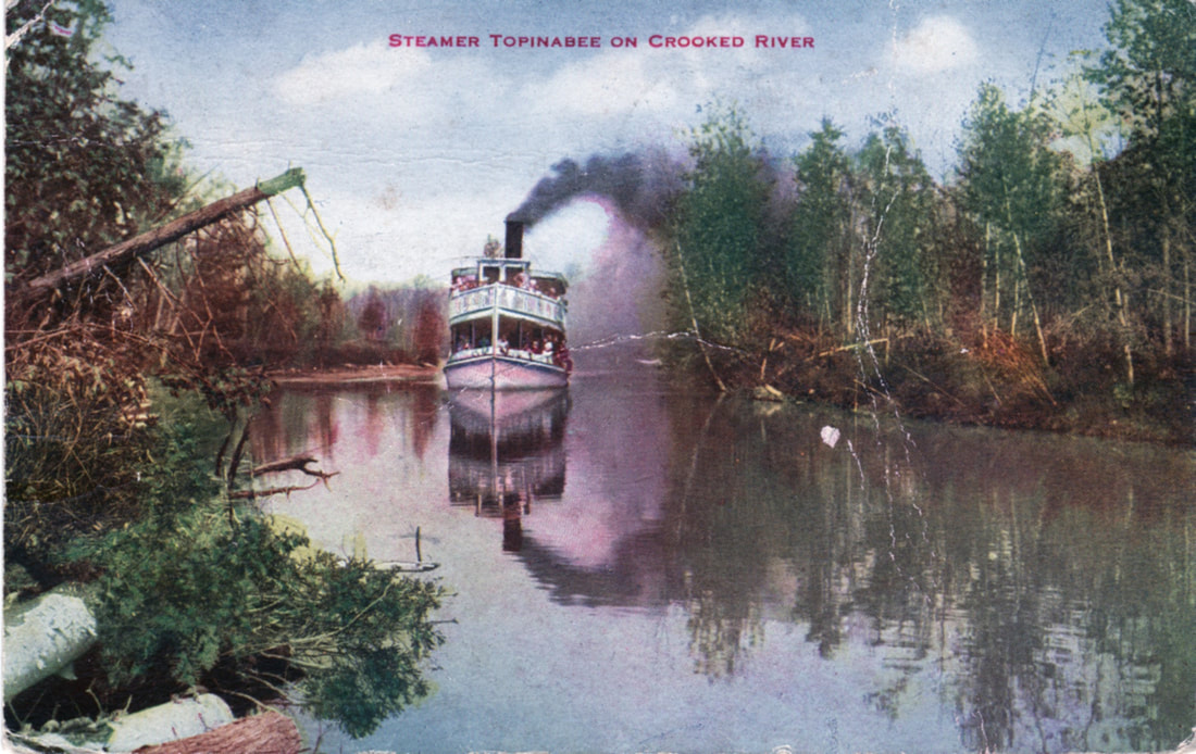
Postcard post marked 1915 of Steamer Topinabee on Crooked River ~ Submitted by Paul VanWagoner from the Collection of the Treloar Family with permission to post only on this Northern Mich~Mash Preserve website
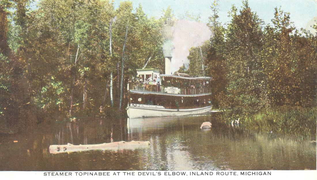
Greenwood Postcard Archive Collection (Undated)
Greenwood Postcard Archive Collection (Undated)
|
Greenwood Postcard Archive Collection (Undated)
|
5 August 1903 ~ The Petoskey Record
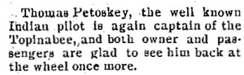
Regarding Articles Above and Right about the Topinabee Captain Tom Petoskey: Notice the 1904 poem below written in honor of the same Captain Thomas F. Petoskey.
|
6 July 1904 ~ The Petoskey Record
|
5 October 1904 ~ The Petoskey Record
1 May 1907 ~ The Petoskey Record
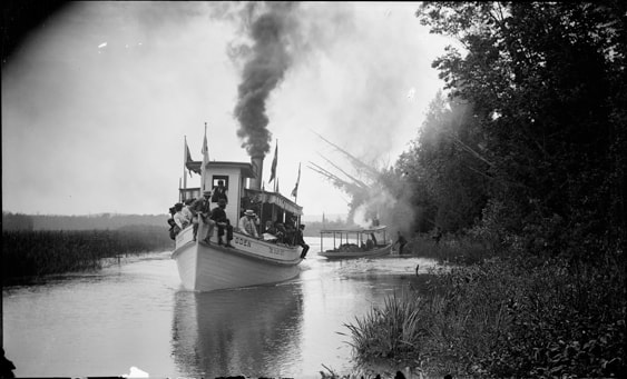
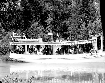
Two Photos Below: Steamer Oden
Steamer Oden
Little Traverse Historical Society Photo Collection (Undated)
27 August 1894 ~ The Daily Resorter
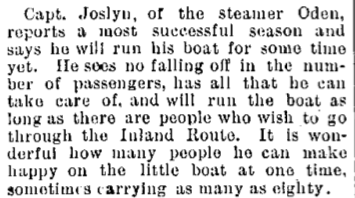
6 September 1895 ~ The Daily Resorter
Steamer Romeo
|
Steamer Romeo ~ Little Traverse Historical Society Photo Collection
|
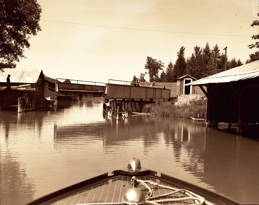
Photo Below: Steamer Topinabee by Alanson Swing Bridge (Tug was F.D. Merchant)
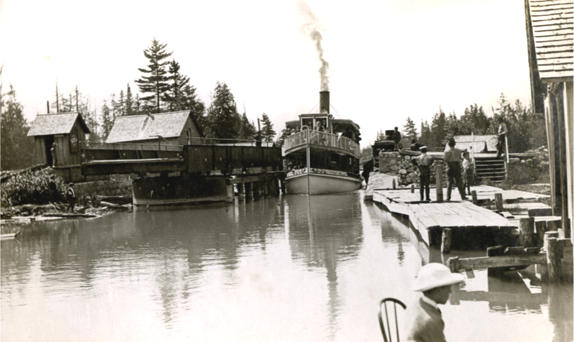
Little Traverse Historical Society Photo Collection (Undated)
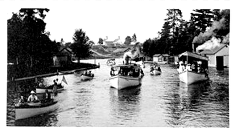
The next four items below are all from the
5 August 1974 ~ Northern Michigan Graphic Resorter Conway Centennial Edition.
5 August 1974 ~ Northern Michigan Graphic Resorter Conway Centennial Edition.
5 August 1974 ~ Northern Michigan Graphic Resorter
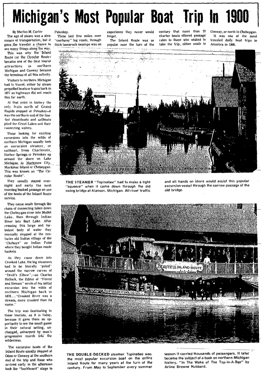
Photo Below: Steamer "Topinabee" at the Topinabee dock on Mullet Lake

Little Traverse Historical Society Photo Collection (Undated)
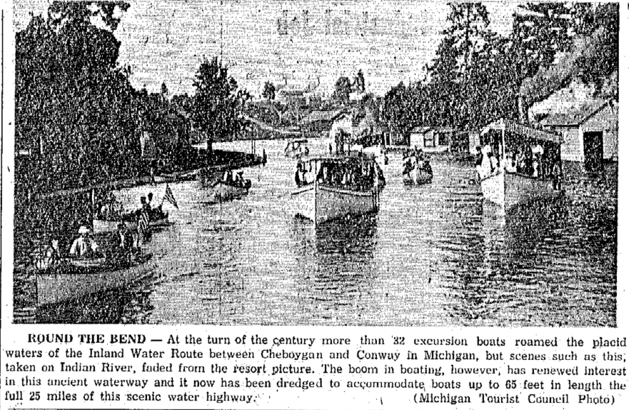
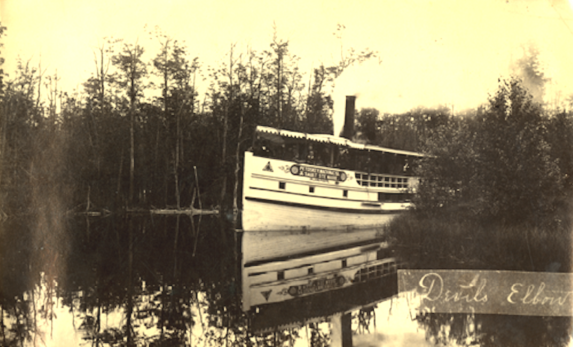
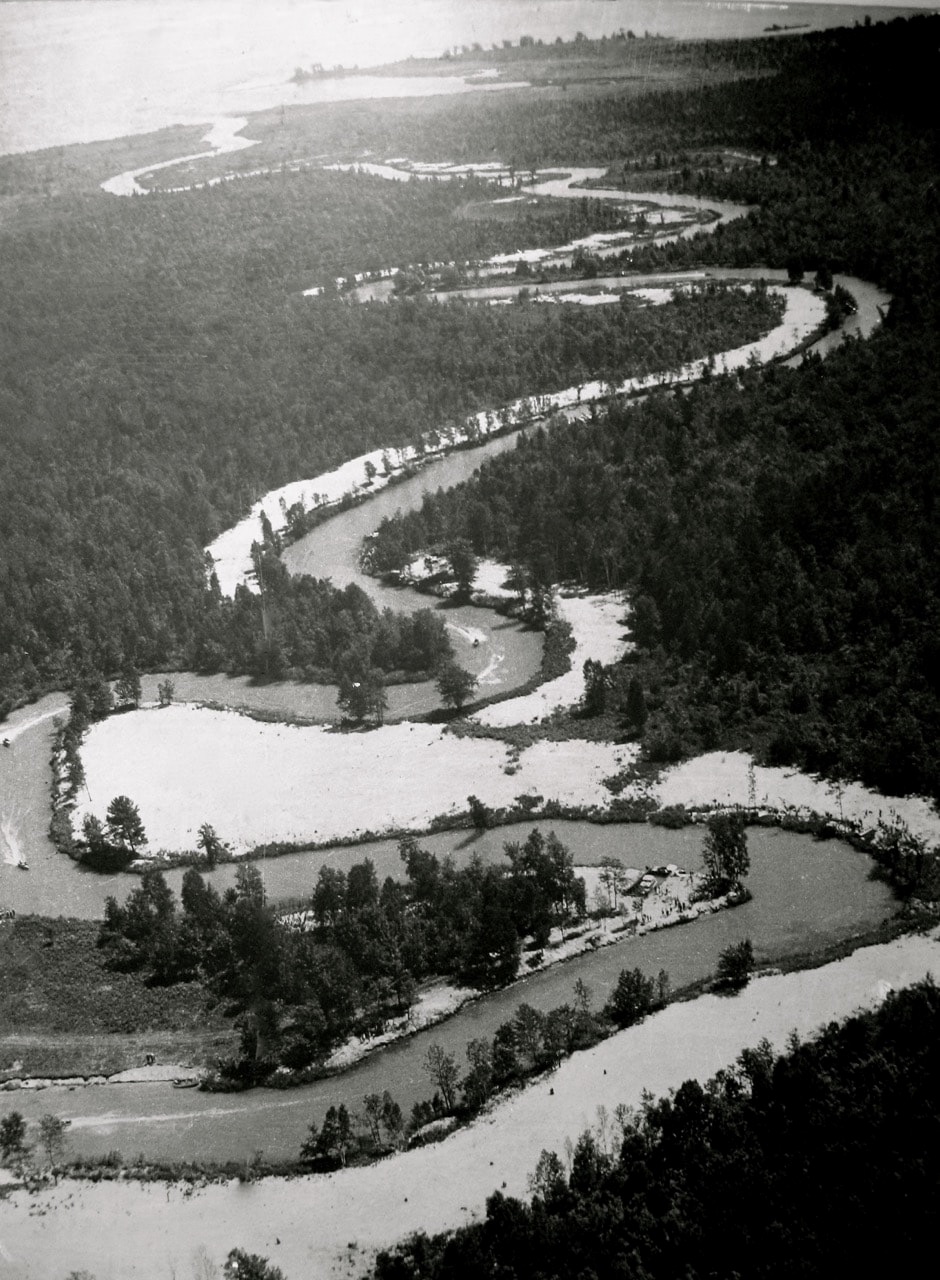
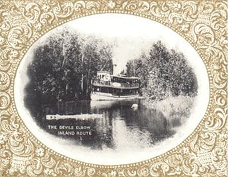
Photo Below was on the cover of the 5 August 1974 ~ Northern Michigan Graphic Resorter: "The steamer of the Petoskey Mackinac Island and Sault St. Marie Navigation Company comes around the bend of one of the many curves of 'Devil's Elbow' on Crooked River loaded with passengers on the famous Inland Route around 1900. These excursion boats put Conway on the map."
5 August 1974 ~ Northern Michigan Graphic Resorter
1910
13 July 1910 ~ The Petoskey Record
|
~ Ida L. Travels Indian River
to Cheboygan ~ 1910 
30 July 1910 ~ Petoskey Evening News
|
~ Private Launch
Through the Inland Route ~ 1910 
3 August 1910 ~ The Petoskey Record
|
~ Topinabee Name Changed to Pe-To-se-ga ~
1911
1911
21 June 1911 ~ The Petoskey Record
|
2 July 1911 ~ Petoskey Evening News
For additional information about the steamers in the surrounding area, including the Steamer Columbia mentioned in the article above, visit (on this same site) "Petoskey Waterfront," toward the bottom of its web page, by clicking HERE.
|
Little Traverse Historical Society Photo Collection (Undated)
Photo Below: The Normich was the last commercial vessel on the Inland Route.
Normich was built by Dagwell at Indian River, Michigan.
Normich was built by Dagwell at Indian River, Michigan.
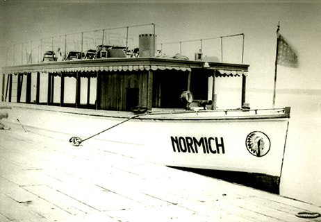
Little Traverse Historical Society Photo Collection (Undated)
Crooked Lake Yields Relic (Anchor) of Steamer Days
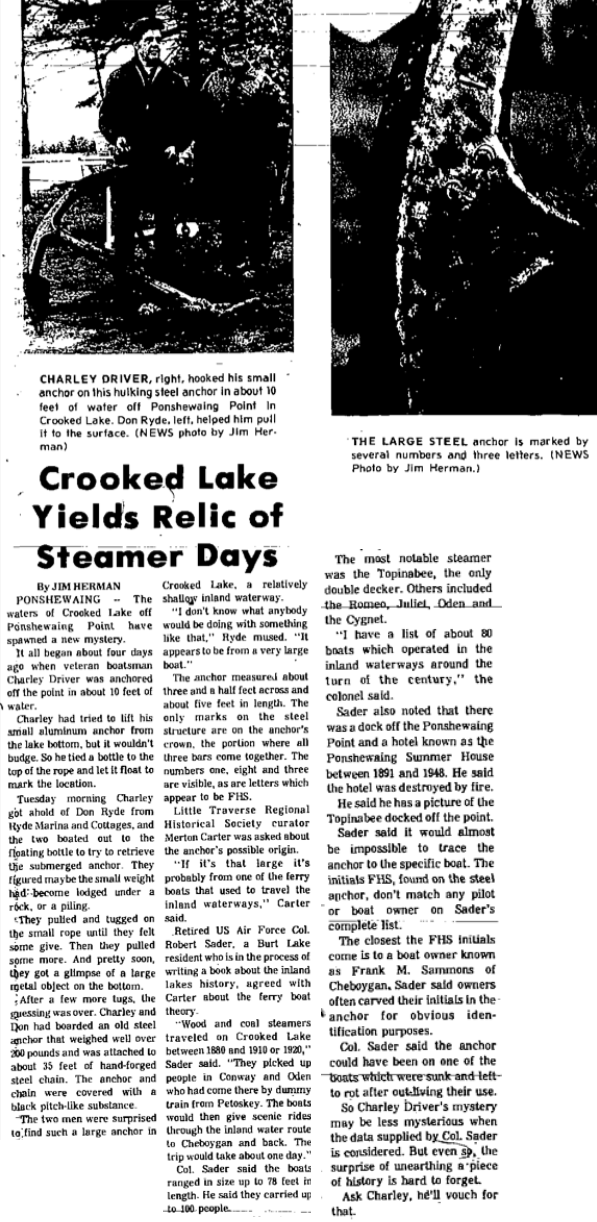
30 October 1975 ~ Petoskey News Review
|
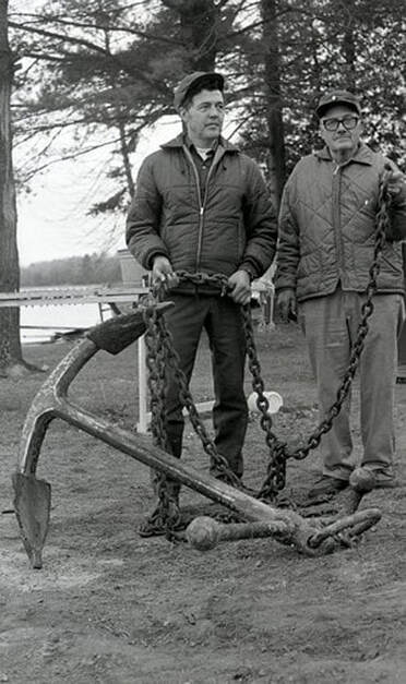
Greenwood Photo Archive Collection from Petoskey News Review (30 October 1975)

Greenwood Photo Archive Collection from Petoskey News Review (30 October 1975)
|
Article Below: Valuable Resort Land on the Crooked River
1903
1903
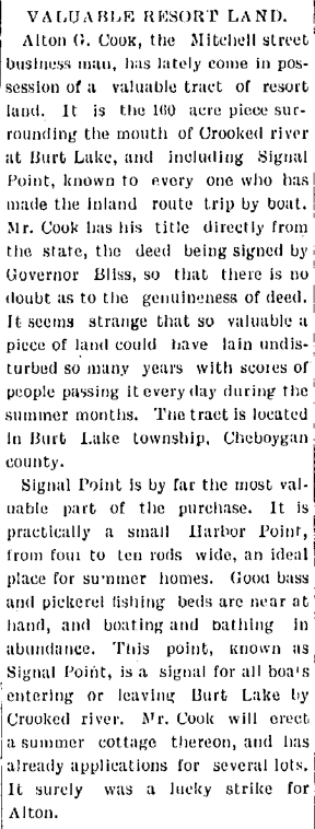
20 February 1903 ~ The Independent Democrat
TOP
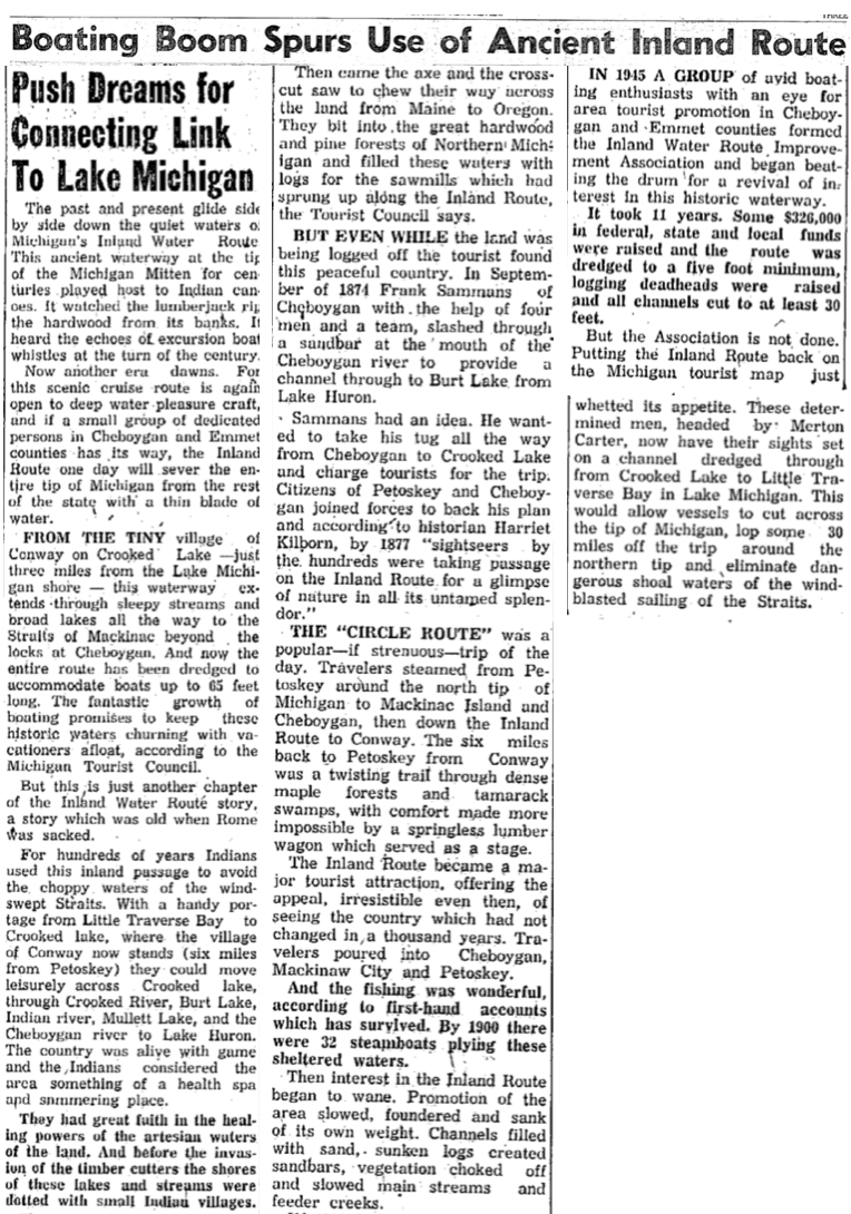
1945
The State of Michigan suggested lengthening the waterway by providing canals from Crooked Lake at Conway
to Little Traverse Bay by way of Round Lake, by virtue of construction of locks.
Even in 2021, the Inland Route does not connect to Little Traverse Bay.
to Little Traverse Bay by way of Round Lake, by virtue of construction of locks.
Even in 2021, the Inland Route does not connect to Little Traverse Bay.
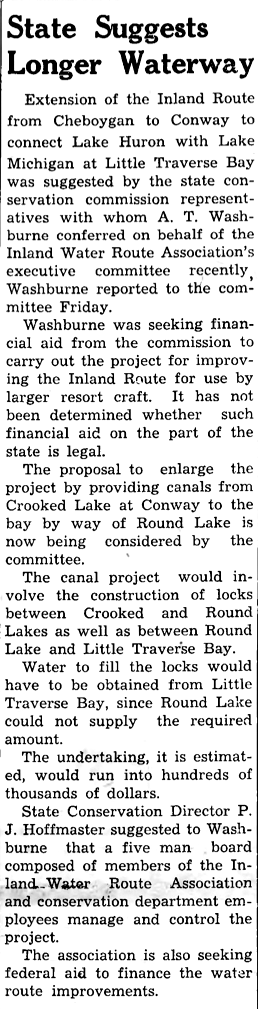
23 August 1945 ~ Emmet County Graphic
1946
29 July 1946 ~ Petoskey Evening News
30 July 1946 ~ Petoskey Evening News
~ Purpose to Rehabilitate and Make Navigable the Inland Water Route ~
1946
1946
1 August 1946 ~ Northern Michigan Review article continued below...
1 August 1946 ~ Northern Michigan Review article continued from above...
3 August 1946 ~ Petoskey Evening News
5 August 1946 ~ Cheboygan Daily Tribune
Greenwood Photo Archive Collection from Petoskey newspapers (6 August 1946)
8 August 1946 ~ Cheboygan Daily Tribune
10 August 1946 ~ Petoskey Evening News
1948

18 September 1948 ~ Petoskey Evening News headline accompanied two photos below...

18 September 1948 ~ Petoskey Evening News
18 September 1948 ~ Petoskey Evening News
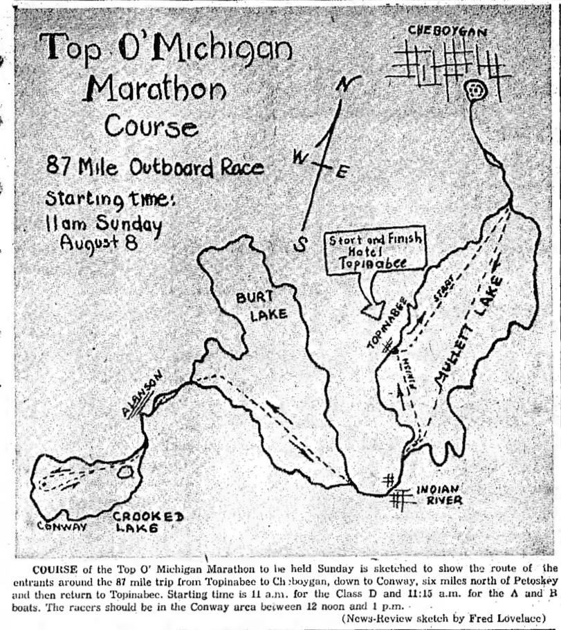
Photo Below: Thousands to view the Inland Route Speed Boat Marathon
1949
1949
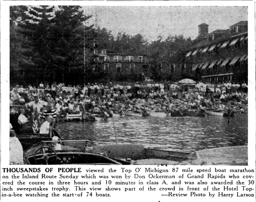
8 September 1949 ~ Northern Michigan Review
8 July 1954 ~ Petoskey Evening News
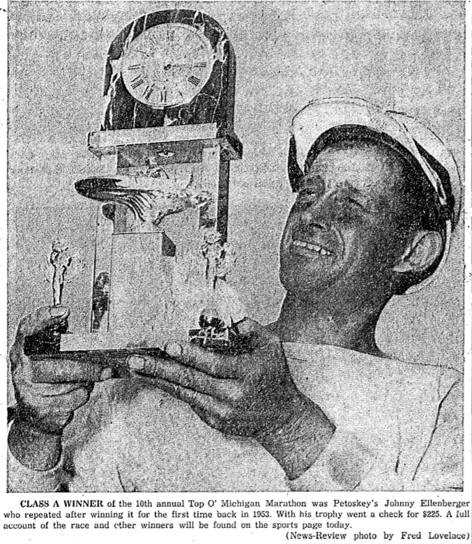
13 August 1953 ~ Northern Michigan Review
Photo Below Left: Viewers of the Top O'Michigan Marathon drove to various spots
and parked at a vantage where the boats could be viewed coming through the inland waters.
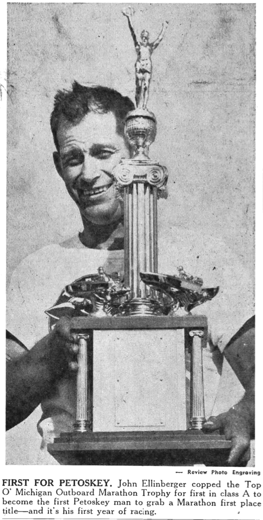
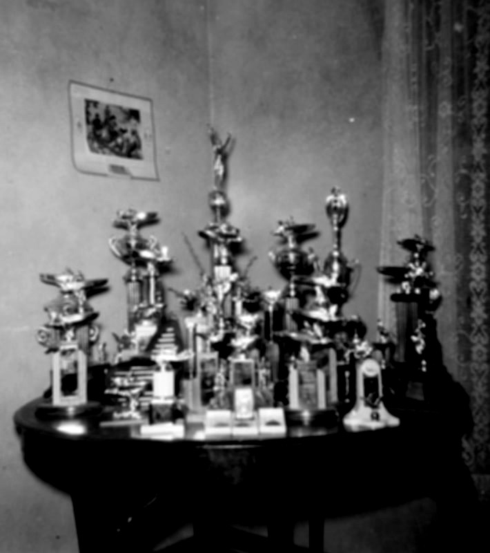
Photo Below Right: Trophies won by John Ellenberger who raced in MANY Top O'Michigan Marathons
and parked at a vantage where the boats could be viewed coming through the inland waters.
Photo Below Right: Trophies won by John Ellenberger who raced in MANY Top O'Michigan Marathons
About 1956 ~ Submitted by S. Buckmaster
|
About 1956 ~ Submitted by S. Buckmaster
|
21 July 1958 ~ Petoskey News Review
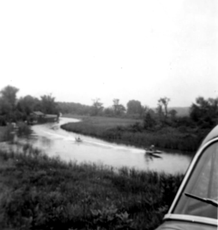
Postcard Below: Early Days of The Devil's Elbow on the Inland Route
Greenwood Photo Archive Collection
Photo Below: Devil's Elbow on Crooked River reeks havoc for racers.
1954
1954

9 August 1954 ~ Petoskey Evening News
Photo Below: This 1959 map is very similar to the 1954 map farther above,
but the start and end points appear to be different than on the 1954 map.
but the start and end points appear to be different than on the 1954 map.

16 July 1959 ~ Petoskey News Review
Click HERE to access a video of the Top O' Michigan Marathon for 15 August 2015
captured by remarkable videographer Charles Dawley.
Click HERE to access video of the Top O' Michigan Marathon for 14 August 2017
captured by remarkable videographer Charles Dawley.
captured by remarkable videographer Charles Dawley.
Click HERE to access video of the Top O' Michigan Marathon for 14 August 2017
captured by remarkable videographer Charles Dawley.
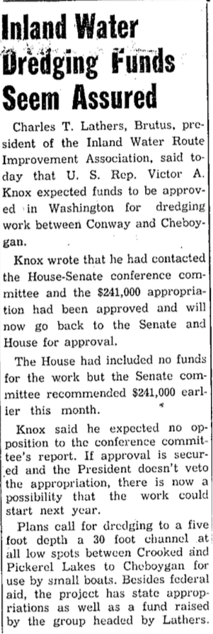
Dredging

25 June 1910 ~ Petoskey Evening News
11 October 1955 ~ Petoskey News Review
Articles Above and Below: Dredging 1910 and 1956 >
31 July 1956 ~ Petoskey News Review
The "Letter Report for a Dredged Material Disposal Area of the Inland Route, Michigan"
may be accessed by clicking HERE.
The report references: "The existing navigation project was completed in 1958... Since 1958, hydraulic dredging operations have been performed as necessary with dredged material disposed along adjacent shorelines. The most recent dredging operations in the Inland Route were conducted in 1970 and 1972."
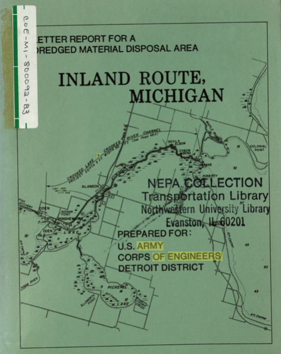
Cover of the Letter Report to be accessed above...
12 July 1955 ~ Petoskey News Review
|

30 August 1956 ~ Petoskey News Review
|
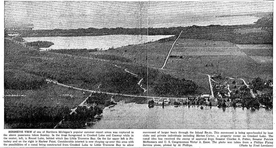
The 1945 (farther above article) proposal for linking Little Traverse Bay to the Inland Route
was again being endorsed in 1956 in the article below.
was again being endorsed in 1956 in the article below.
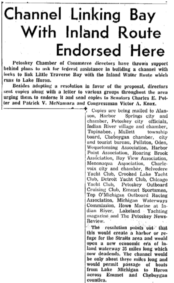
13 June 1956 ~ Petoskey News Review
13 February 1957 ~ Petoskey News Review
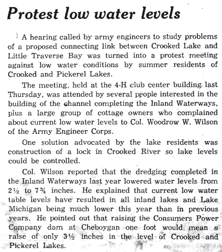
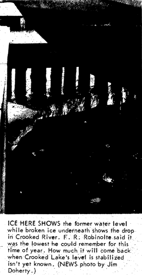
~ Predicts Lower Water at Crooked Lake ~
1958
1958
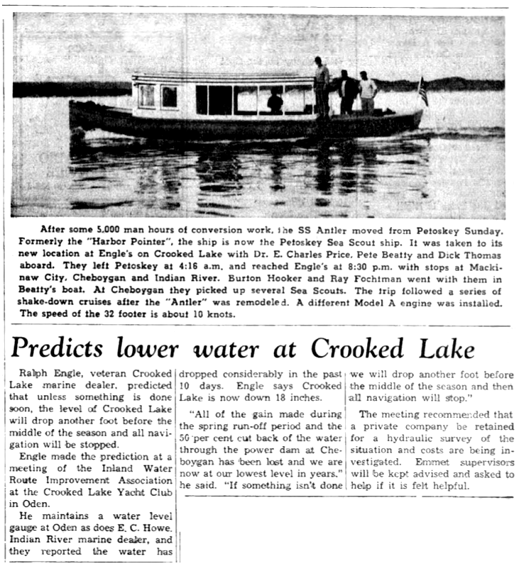
26 June 1958 ~ Emmet County Graphic
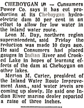
~ Meeting to Discuss the Low Water Levels ~
1958
1958
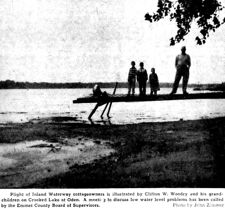
10 July 1958 ~ Emmet County Graphic
10 July 1958 ~ Emmet County Graphic
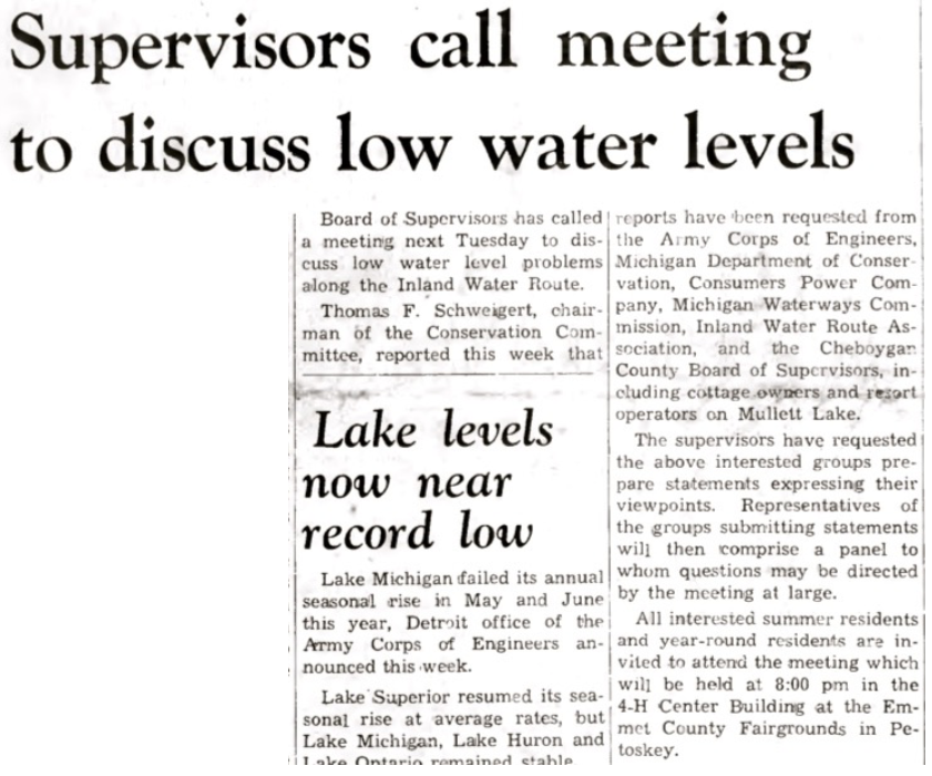
~ Crooked Lake Residents Seek Method to Set Water Levels ~
1958
1958
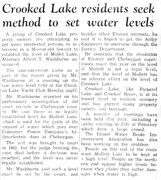
28 August 1958 ~ Emmet County Graphic
~ Welcome Outdoor Writers to Inland Water Route ~
1959
1959
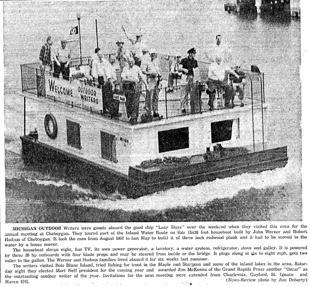
8 June 1959 ~ Petoskey News Review
TOP
~ Lake Levels ~
1958 > 1961
1958 > 1961
27 March 1958 ~ Owosso Argus-Press
|
4 September 1958 ~ Emmet County Graphic
|
27 August 1959 ~ Emmet County Graphic
1959 Article Above: "One solution [to low water levels] advocated by the lake rcsidentswas construction of a lock in Crooked river so lake levels could be controlled."
|
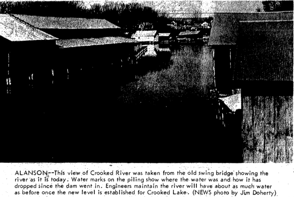
12 May 1958 ~ Petoskey News Review accompanied map below...
12 May 1958 ~ Petoskey News Review map accompanied article above...
16 May 1954 ~ Petoskey News Review
13 February 1957 ~ Petoskey News Review
|
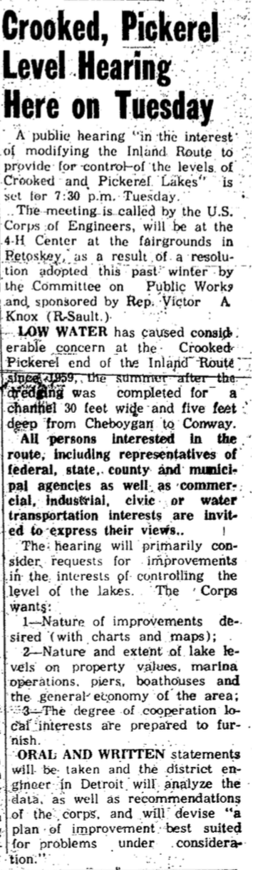
15 July 1961 ~ Petoskey News Review
|
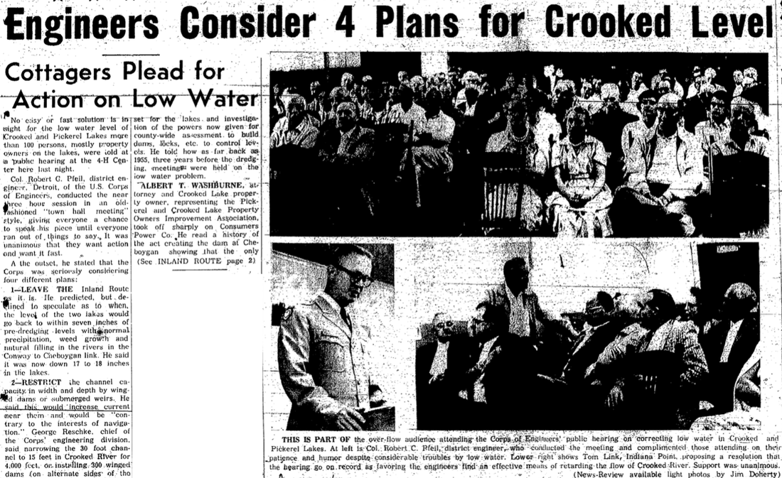
19 July 1961 ~ Petoskey News Review first column continues directly below... Page 2 continues farther down

19 July 1961 ~ Petoskey News Review coninued from column one above...
|
1961 Article Above and continued at Left: "3–A Lock and dam on Crooked River, while costly, would provide positive control. He said it would prove time consuming to boaters." was #3 of the Army Corp of Engineers' four different plans.
|
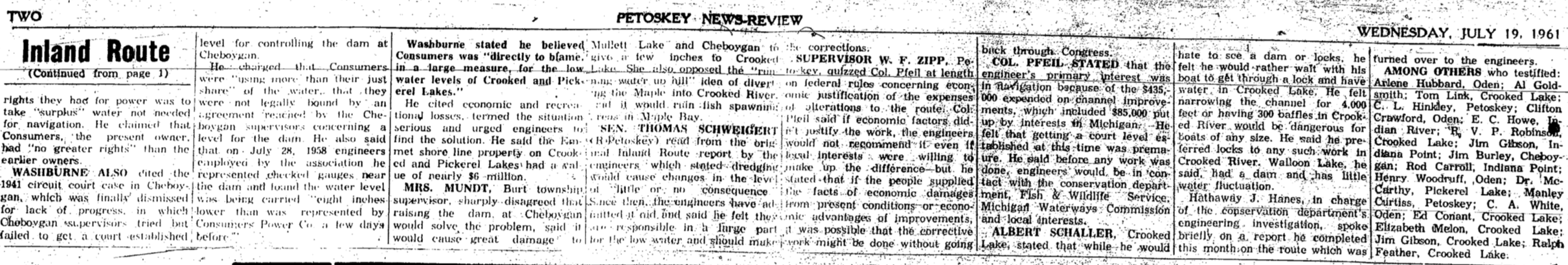
19 July 1961 ~ Petoskey News Review page 2 continuation from above article.
~ Lake Levels ~
1962 and Forward>
1962 and Forward>
Article Below:
The dam and lock were urged to being built
to prevent loss of valuation in the tax base of property around the lake due to the low water.
The dam and lock were urged to being built
to prevent loss of valuation in the tax base of property around the lake due to the low water.

14 October 1962 ~ Petoskey News Review #1 Continued Below...
14 October 1962 ~ Petoskey News Review #2 Continued Below...
14 October 1962 ~ Petoskey News Review #3 Continued from above...
Article Above: Cy Jordan of Oden Island was the developer of Oden Island, so understandably "urged the dam and lock be built to prevent loss of valuation in the tax base of property around the lake due to the low water." Access more information about Oden Island on this same web site by clicking HERE.
Article Below:
Various opinions on the possible good and/or bad outcomes of the water levels of constructing a dam...
Various opinions on the possible good and/or bad outcomes of the water levels of constructing a dam...
3 March 1963 ~ Petoskey News Review
Articles Below: "The dam is to raise the level of Crooked and Pickerel Lakes some 18 inches to pre-1958 levels of before the dredging of the Inland Water Route. The local funds were raised by donations, mostly from residents on Crooked and Pickerel Lakes."
28 April 1965 ~ Petoskey News Review
|
22 September 1966 ~ Petoskey News Review
|
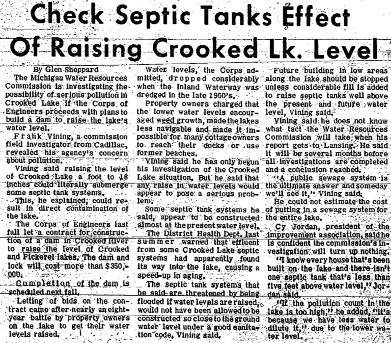
Article Below: "Letting of bids [for building of a dam] on the contract came after nearly an eight-year battle by property owners on the lake to get their water levels raised. Water levels, the Corps admitted dropped considerably when the Inland Waterway was dredged in the late 1950's. Property owners charged that the lower water levels encouraged weed growth, made the lakes less navigable and made it impossible for many cottage owners to reach their docks or use former beaches.
Investigator Frank Vining, however, said that "any raise in water levels would appear to pose a serious problem. Some septic tank systems he said, appear to be constructed almost at the present water level... future building in low areas along the lake should be stopped unless considerable fill is added to raise septic tanks well above the present and future water level."
Investigator Frank Vining, however, said that "any raise in water levels would appear to pose a serious problem. Some septic tank systems he said, appear to be constructed almost at the present water level... future building in low areas along the lake should be stopped unless considerable fill is added to raise septic tanks well above the present and future water level."
20 January 1967 ~ Petoskey News Review
11 February 1967 ~ Petoskey News Review
|
Greenwood Photo Archive Collection from Petoskey News Review (11 February 1967)

Greenwood Photo Archive Collection from Petoskey News Review (11 February 1967)
|
2 December 1967 ~ Petoskey News Review
Dam Effects... after dredging up water level concerns AND funding
1968 >
1968 >
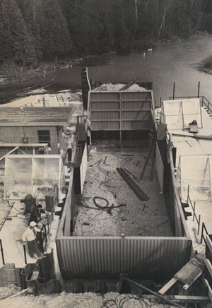
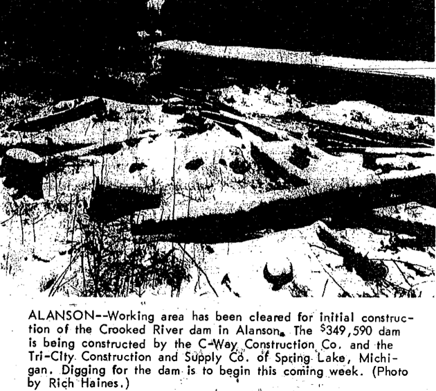
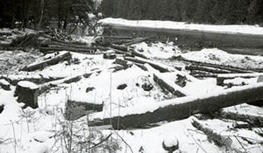
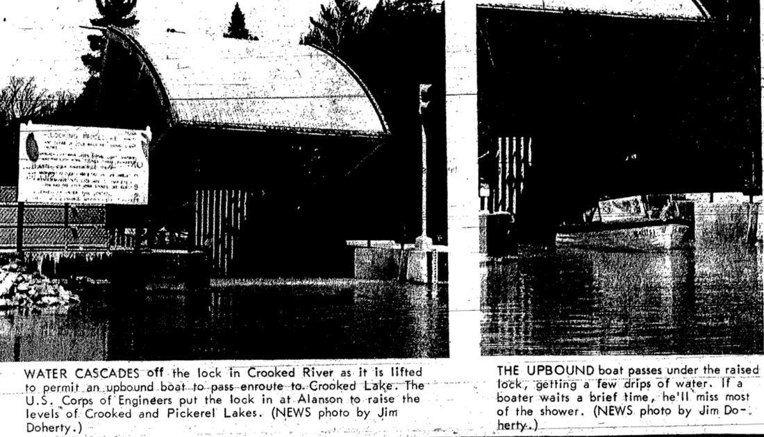
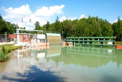
Alanson Lock ~ Greenwood Photo Archive Collection from Petoskey Newspapers
|
Alanson Lock ~ Greenwood Photo Archive Collection from Petoskey Newspapers
|
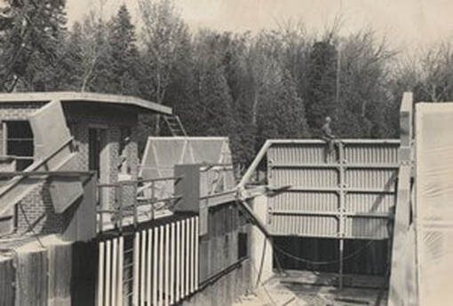
Alanson Lock ~ Greenwood Photo Archive Collection from Petoskey Newspapers
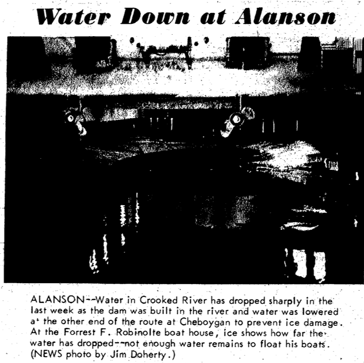
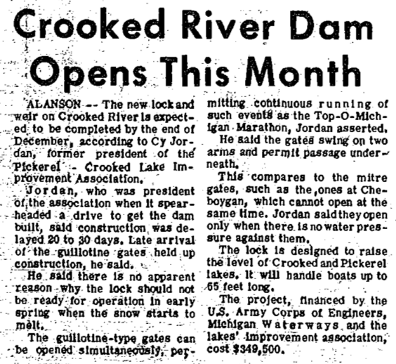
18 March 1968 ~ Petoskey News Review
|
15 March 1968 ~ Petoskey News Review article
|
15 March 1968 ~ Petoskey News Review article
15 March 1968 ~ Petoskey News Review article
1968
3 May 1968 ~ Petoskey News Review
11 May 1968 ~ Petoskey News Review
16 May 1968 ~ Petoskey News Review
4 May 1974 ~ The Argus-Press
4 May 1990 ~ Petoskey News Review... article continues below...

4 May 1990 ~ Petoskey News Review... article continued from above
Article Above: "The Inland Waterway needs to be dredged periodically to keep the channel navigable.
Since the channel is a federal waterway, dredging is the responsibility of the corps."
Since the channel is a federal waterway, dredging is the responsibility of the corps."
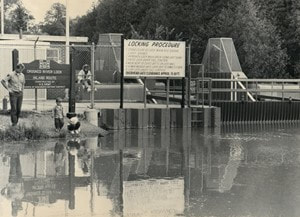
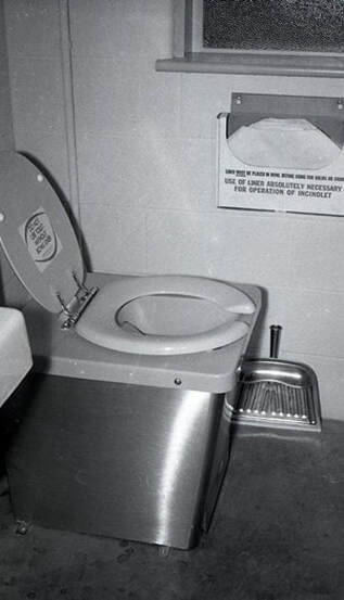
~ Electric Toilet at Alanson Lock ~
1968
1968
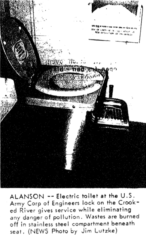
22 May 1968 ~ Petoskey News Review
|
Greenwood Photo Archive Collection from Petoskey News Review (22 May 1968)
|
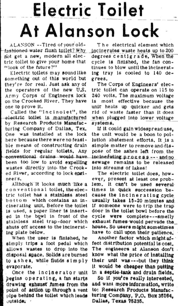
22 May 1968 ~ Petoskey News Review
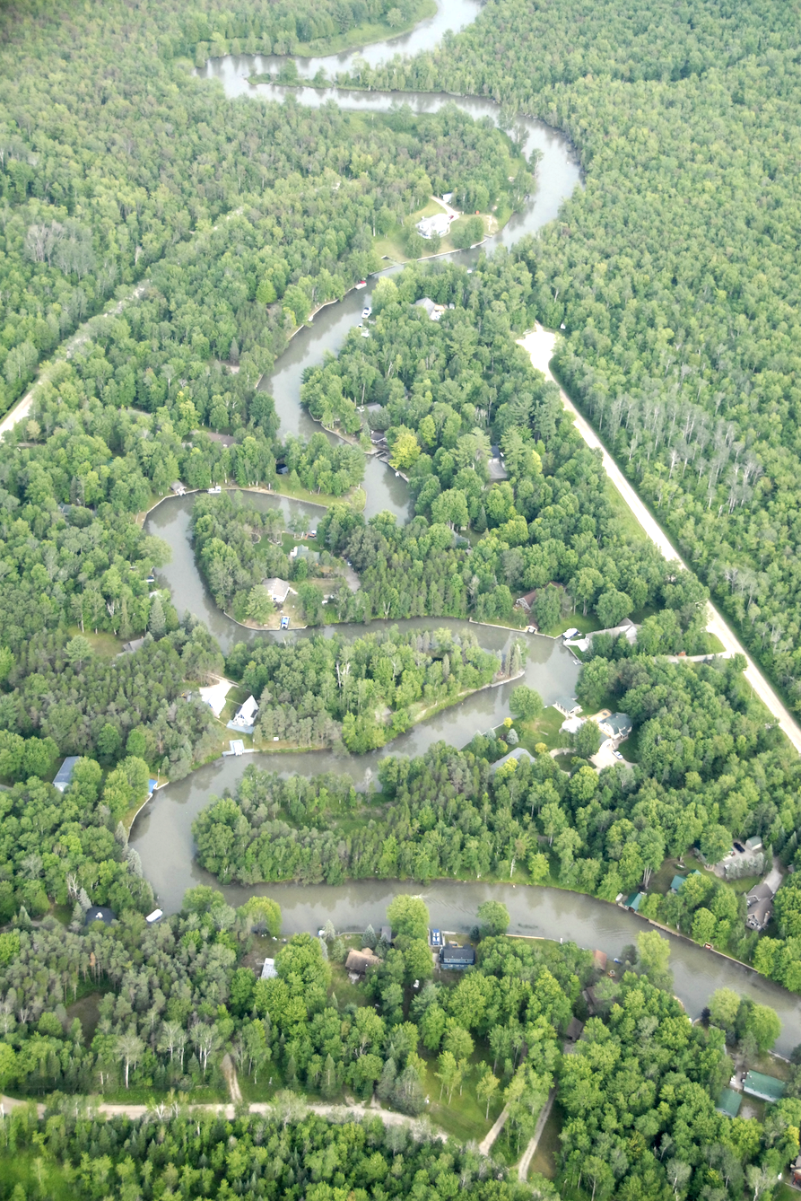
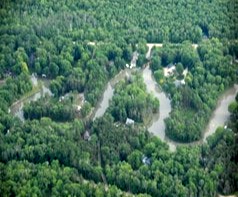
~ Crooked River from the Air ~
1976
1976
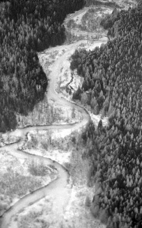
Greenwood Photo Archive Collection from Petoskey newspapers (February 1976)
~ Alanson Man Enjoys Model-Making ~
1984
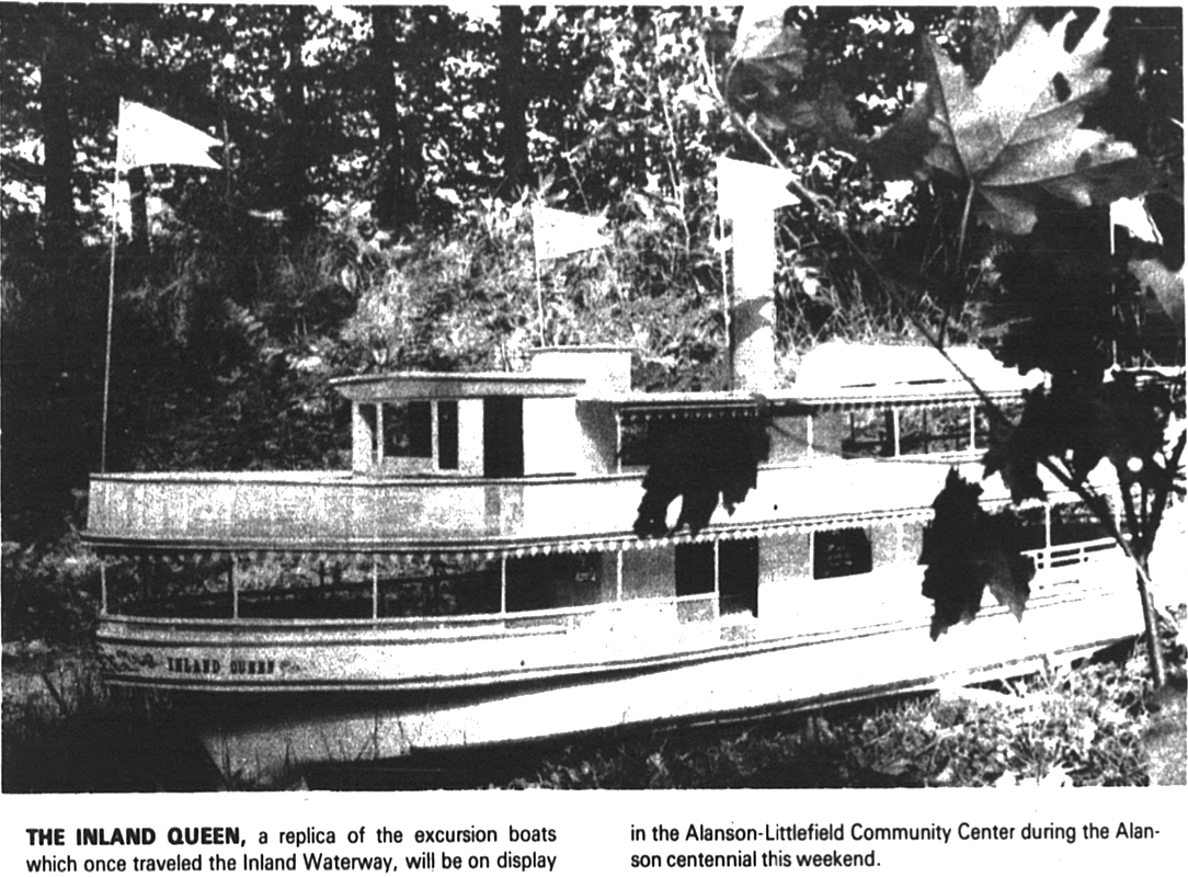
1 July 1982 ~ The Graphic photo accompanied article below...
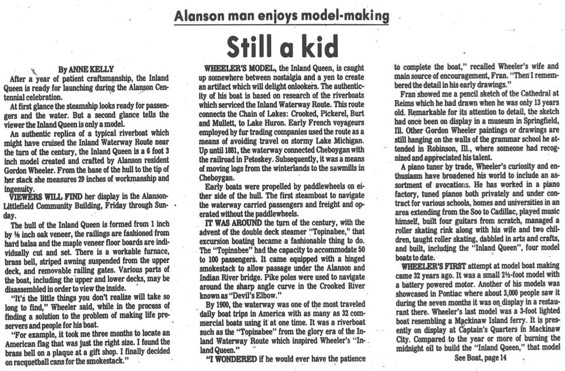
1 July 1982 ~ The Graphic article continued from photo above and to the text below right...

1 July 1982 ~ The Graphic article continued from article above at right...
~ Inland Waterway–A Fascinating Journey ~
1984
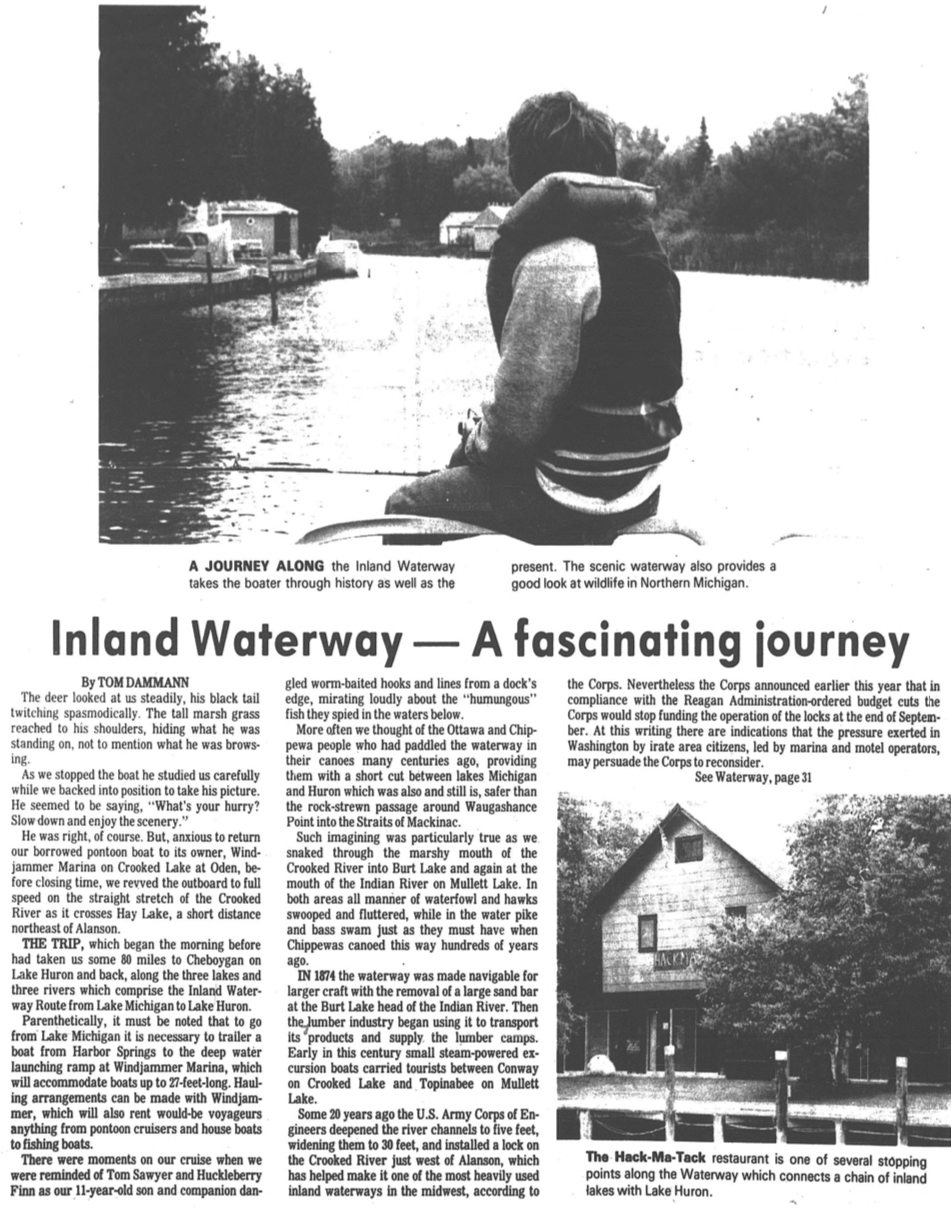
8 July 1982 ~ Petoskey News Review article continued below...
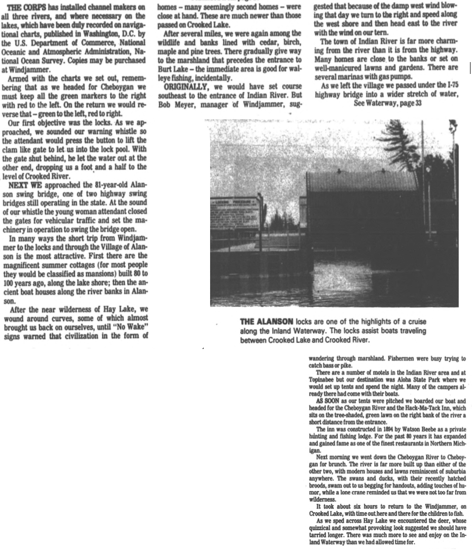
8 July 1982 ~ Petoskey News Review article continued from above...
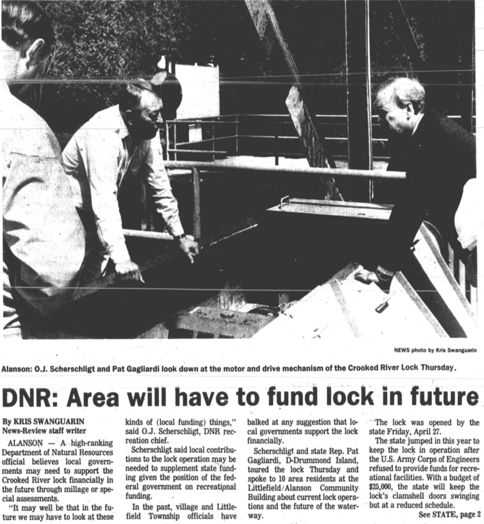
~ Alanson Lock Runs at Profit ~
1984
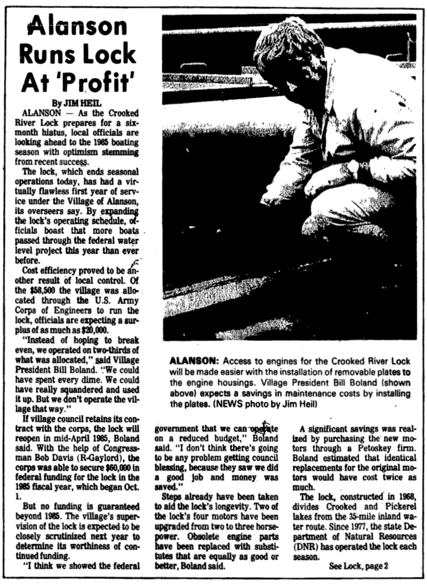
31 October 1984 ~ Petoskey News Review... article continued below
31 October 1984 ~ Petoskey News Review... article continued from above
~ Ideas for the Alanson Lock ~
1988
1988
22 June 1988 ~ Petoskey News Review
~ Would Lower Lake Level by Three Quarters of an Inch ~
1988
1988
29 June 1988 ~ Harbor Light
~ Waterway Ownership and Operations ~
1988
11 July 1988 ~ Petoskey News Review
~ Lake Levels Lowest in 10 Years ~
1989
1989
28 April 1989 ~ Harbor Light
|
28 April 1989 ~ Harbor Light
|
~ Alanson Lock Needs Funding ~
1989
1989
24 October 1989 ~ Petoskey News Review
~ River Lock Negotiations Continue ~
1989
1989
Article Below: "The issues of who will fund the lock has been tossed around annually for several years. The Corps has threatened to drop lock funding ever since it made a policy decision to eliminate funding for recreational navigation projects... Water level maintenance is the only portion of the lock the Corp is committed to maintaining."
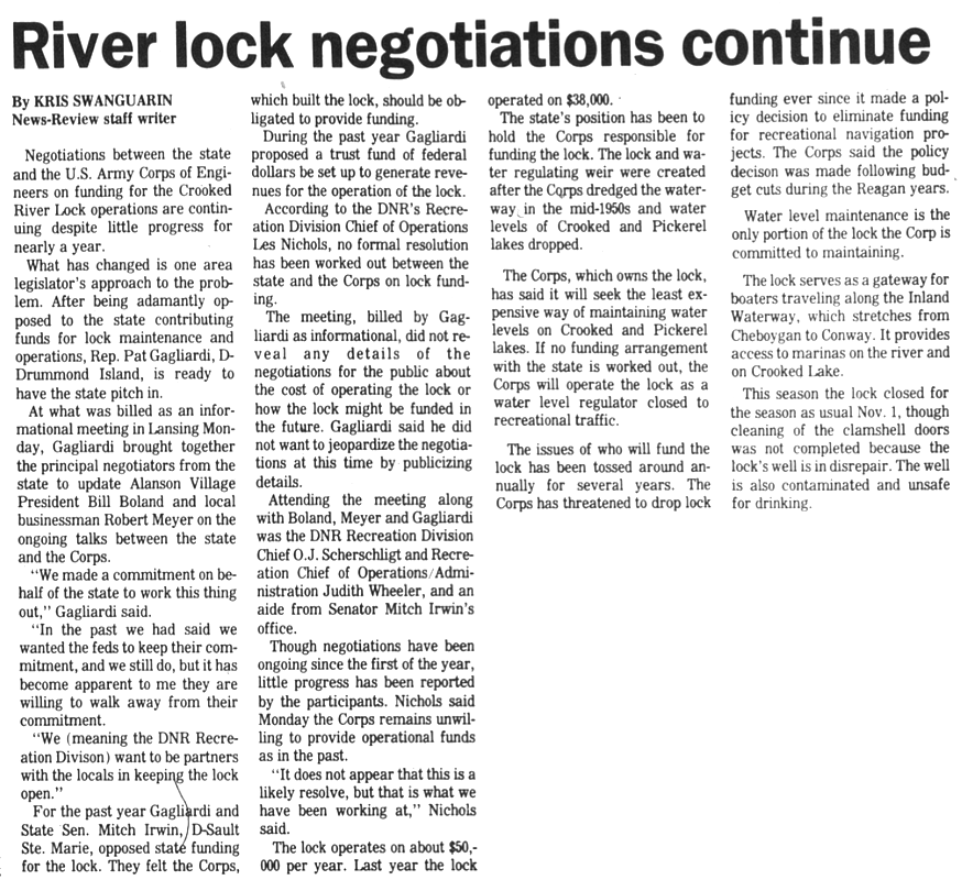
19 December 1989 ~ Petoskey News Review
~ Devil's Elbow a Navigational Challenge ~
1994
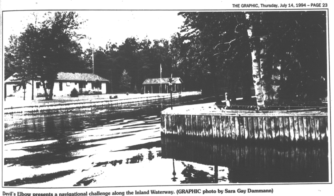
14 July 1994 ~ Petoskey News Review
~ Dredging Annoys Neighbors ~
1999
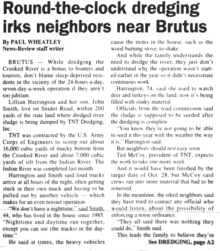
4 November 1999 ~ Petoskey News Review article continued below...
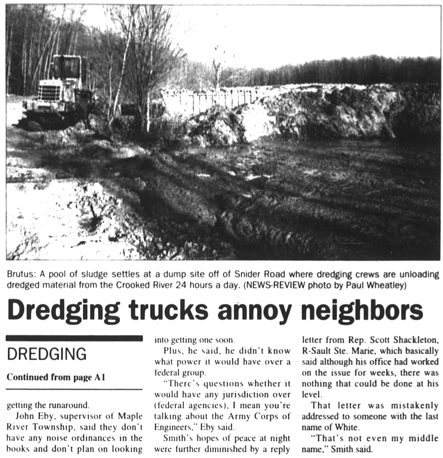
4 November 1999 ~ Petoskey News Review article continued from above...
The undated Inland Waterway brochure below was created and promoted by Emmet County.
2018
Crooked River's Inland Waterway Winter Beauty
2 January 2018 ~ Photography of "Alex Childress Photo" posted here with permission...
Photo Above: Alex Childress' additional work also may be viewed at Alex Childress Photo...
Same setting above as the 1963 photo below.
Same setting above as the 1963 photo below.
Greenwood Photo Archive Collection fro Petoskey newspapers (January 1963)
2010
Alanson Riverfest at the Crooked River Lock
Alanson Riverfest at the Crooked River Lock
Greenwood Photo Archive Collection from Petoskey newspapers (14 August 2010)
Greenwood Photo Archive Collection from Petoskey newspapers (14 August 2010)
|
Greenwood Photo Archive Collection from Petoskey newspapers (14 August 2010)
|
10 August 2019
Click PLAY in upper left corner of photo below
to view the slideshow of the Crooked River Lock in use...
Click PLAY in upper left corner of photo below
to view the slideshow of the Crooked River Lock in use...
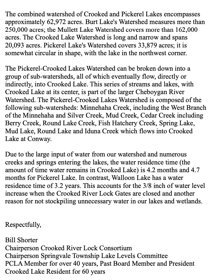
Below: The 1995 "Pickerel–Crooked Lakes Watershed Nonpoint Source Pollution Management Plan" gives a tremendous description of the two lakes and their relationship to the Crooked River PRIORITIES: Changing Land Use, Stormwater, Shoreline Management, Agriculture, Road/Stream Crossings, and Logging Activities. The priorities relate to the tributaries and surrounding wetlands of the two lakes which eventually empty into the Crooked River, the only outlet for the two lakes, to travel the inland waterway, to connect eventually with Lake Huron on the east side of the State of Michigan.
Dam/Lock Debate Continues...
(Funding, Maintenance, Operation, AND Water Levels)
(Funding, Maintenance, Operation, AND Water Levels)
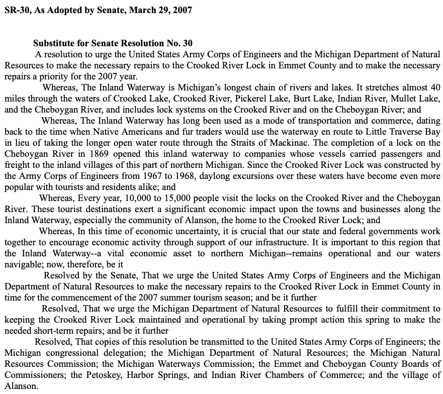
29 March 2007 ~ State of Michigan Senate Resolution No. 30
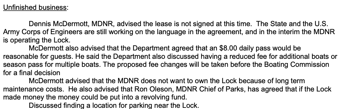
Below: Dan Plascencia was an Emmet County Board of Commissioner who lived on the shallow side of Crooked Lake, and had a vested interest on maintaining the locks to help maintain a higher lake water level.
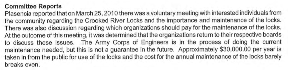
13 April 2010 ~ ECBOC Administrative Meeting Minutes
Greenwood Photo Archive Collection from Petoskey Newspaper (2010)
Greenwood Photo Archive Collection from Petoskey News Review (2010)
|
Greenwood Photo Archive Collection from Petoskey News Review (2010)
|
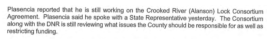
28 April 2011 ~ Crooked River (Alanson) Lock Consortium Meeting Minutes
24 January 2012 ~ ECBOC Administrative Meeting Minutes
12 October 2012 ~ Cheboygan Daily Tribune
2012 Article Below: "The Crooked River Lock in Alanson controls the water levels of Crooked Lake, which are set by the Army Corps of Engineers. Through Sept. 30, the lake's levels were to be 594.7 feet. By Nov. 1, the level is to be 594 feet."
17 October 2012 ~ Petoskey News Review article continued below...
17 October 2012 ~ Petoskey News Review article continued from above...
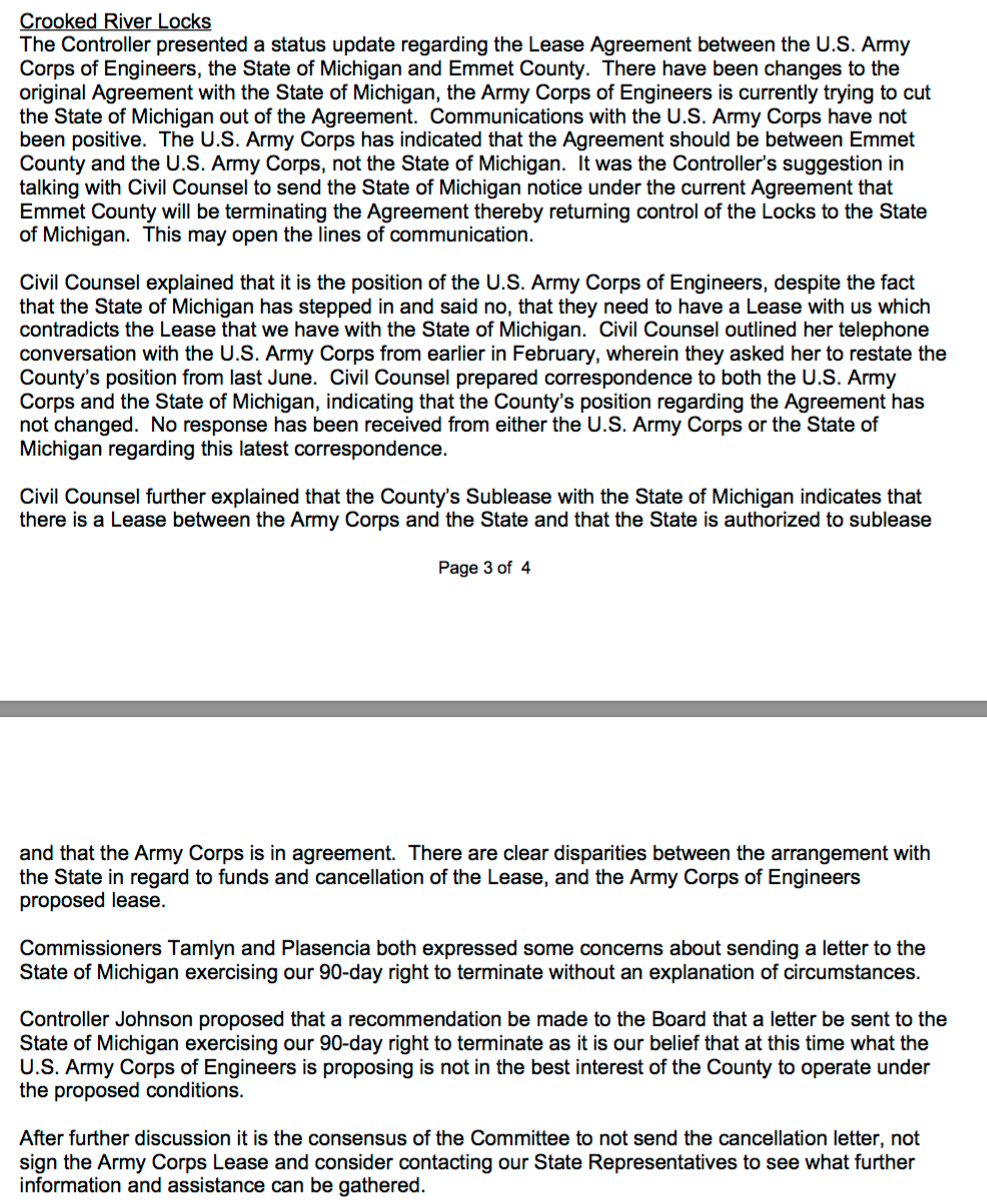
11 December 2012 ~ECBOC Building & Ground Committee Meeting Minutes
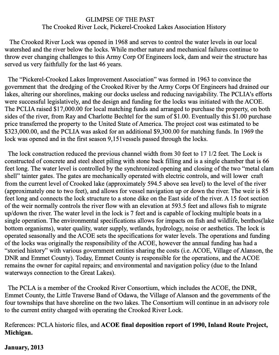
The following "Glimpse of the Past" with history of the Crooked River Lock may also be accessed on-line,
by clicking HERE.
"The gates are mechanically operated with electric controls, and will lower craft from
the current level of Crooked Lake (approximately 594.5 above sea level) to the level of the river...
A 15 foot section of the weir normally controls the river flow with an elevation at 593.5 feet."
PCLIA = Pickerel–Crooked Lakes Improvement Association
USACE and ACOE = Army Corps of Engineers
January 2013 ~ Pickerel Crook Lakes Assoctiation
19 February 2013 ~ ECBOC Building & Grounds Meeting Minutes
12 March 2013 ~ ECBOC Building & Grounds Meeting Minutes
16 May 2013 ~ ECBOC Meeting Minutes

16 May 2013 ~ ECBOC Meeting Public Comment
The Crooked River Lock Consortium posted information on the Emmet County Website as of 16 May 2013:
"Crooked River Lock now under County operation
The Crooked River Lock in Alanson is under new operational management, with Emmet County partnering with the Michigan Department of Natural Resources to run the lock."
AND
"About the Crooked River Lock Consortium
The Crooked River Lock Consortium was formed in 2010 and consists of representatives from Emmet County, the village of Alanson, and the townships of Bear Creek, Littlefield, Little Traverse and Springvale [Those 4 townships surround the water area represented]. It also includes representation from the Pickerel-Crooked Lake Association.
Emmet County Commissioner Dan Plasencia is the county representative on the committee.
The Consortium's purpose is to look into the preservation, enhancement and continued operation of the Crooked River Lock in Alanson for the betterment of tourism and economic development, lake owners and also the boating public.
The Consortium is working with the Michigan Department of Natural Resources and the Army Corps of Engineer to secure funding for maintenance of the locks, increased hours of operation and other needs as they arise."
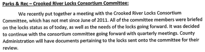
15 December 2016 ~ ECBOC Meeting Minutes

19 December 2016 ~ ECBOC Parks & Recreation Board Meeting Minutes
Article Below:
"Raise lake level to elevation 595.4 ft (IGLD 1985) by May 27, and hold 595.4 ft, or as near as possible,
through Sept 30."
"Raise lake level to elevation 595.4 ft (IGLD 1985) by May 27, and hold 595.4 ft, or as near as possible,
through Sept 30."
17 October 2017 ~ Petoskey News Review
Memorandum of 9 April 2018 Below:
Emmet County's Civil Counsel Engel's opinion regarding Crooked River Lock Operating Agreement...
Emmet County's Civil Counsel Engel's opinion regarding Crooked River Lock Operating Agreement...
Memorandum of 15 May 2018 Below: Emmet County Parks and Recreation Director Marci Schmiege's,
response about Civil Counsel's above Opinion on Crooked River Lock Operating Agreement...
response about Civil Counsel's above Opinion on Crooked River Lock Operating Agreement...
Relate the 15 May 2018 quandary reported below with the minutes farther above of 19 December 2016 stating
"The county has signed a new 5 year agreement with the state to manage the locks."
"The county has signed a new 5 year agreement with the state to manage the locks."
15 May 2018 ~ Petoskey News Review (Authored by William Perkins)
23 May 2018 ~ Petoskey News Review
William T. Perkins reported in an additional article in the 25 May 2018 in the Petoskey News Review that
"5–year Crooked River Lock plan passes on small margin."
The article may be accessed by clicking HERE.
"5–year Crooked River Lock plan passes on small margin."
The article may be accessed by clicking HERE.
TOP
Two Letter Copies Below Provided to Priscilla Meyer the secretary of the Emmet County Parks & Recreation Board
Included in the P&R minutes for 1 December 2020 at 12:30AM via ZOOM:
From Emmet County Commissioner Shorter to members of USACE (US Army Corps of Engineers).
The first letter below is not dated, but content indicates it perhaps preceded the letter following below.
Included in the P&R minutes for 1 December 2020 at 12:30AM via ZOOM:
From Emmet County Commissioner Shorter to members of USACE (US Army Corps of Engineers).
The first letter below is not dated, but content indicates it perhaps preceded the letter following below.
Included in the ECBOC P&R minutes for 1 December 2020 at 12:30AM via ZOOM:
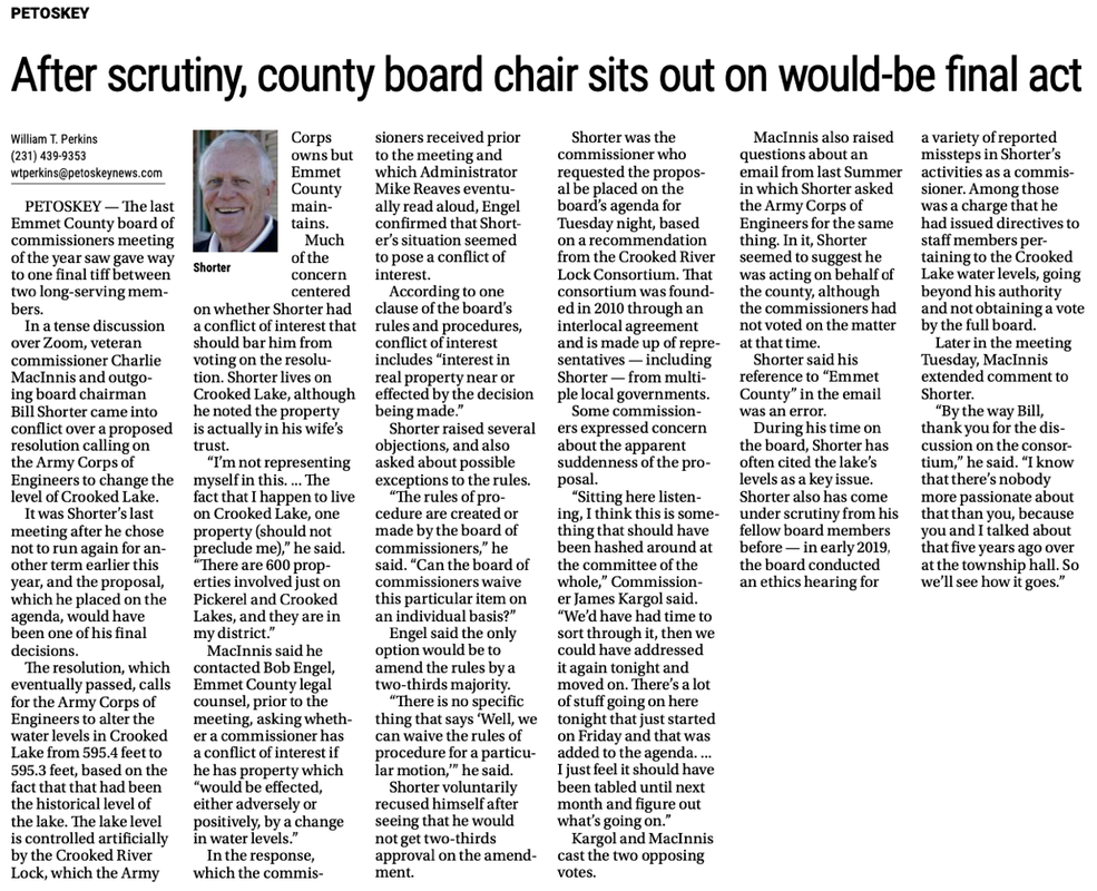
Bill Shorter acknowledged at the 22 December 2020 ECBOC meeting (noted farther below) that he had not had
full board approval for suggesting in the letter above to ask the USACE to change the IGLD lake level readings.
The e-mail below from Bill Shorter was dated 28 November 2020.
full board approval for suggesting in the letter above to ask the USACE to change the IGLD lake level readings.
The e-mail below from Bill Shorter was dated 28 November 2020.
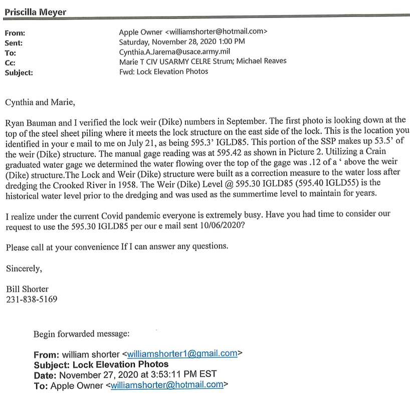
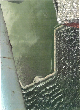
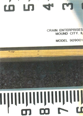
This e-mail refers to the three photos posted below...
|

|
|
Below: Minutes from the Emmet County Parks & Recreation Board Minutes referencing above 2 letters and 3 photos
1 December 2020
1 December 2020
1 December 2020 ~ Emmet County Parks & Recreation Board Minutes
Below:
Consideration of "The Process of Government" is often as important, or more so,
than what is being discussed and/or decided by the government.
Consideration of "The Process of Government" is often as important, or more so,
than what is being discussed and/or decided by the government.
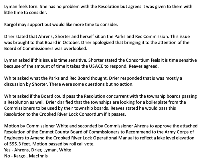
The following Summary and Recommendation to the ECBOC with Civil Counsel Review/Recommendation and possible Motion were all included in the meeting packet for 22 December 2020, BUT ONLY AFTER being posted on the agenda at a late date, which was not acceptable, nor according to the Commissioners' own "Rules of Procedure". While a disclaimer does state on the county's web site agenda page to continue checking the agenda for changes right up to the the meeting time, that unsigned statement should not supersede the Rules of Procedure (as shown below). Commissioners, in their open meeting conversations, stated that the information had been passed to the other commissioners on Friday (December 18th); however, some commissioners actually did not recognize notice until the following business day of the 21st, with the meeting date being on December 22nd... not acceptable for commissioners nor the public, as ruled within a "three business days" notice time. Another commissioner duly noted that the Parks & Recreation Board had known about the water level situation per their 1 December 2020 meeting (see above P&R minutes), and that particular commissioner always forwards those minutes to all of the commissioners; although the minutes do not mention any urgent need for the commissioners to be pondering a resolution. It was more like an update or report of the situation, not a recommendation for the ECBOC to approve a possible resolution in the very near future, nor was it verbally brought forward to a full board meeting. A couple of commissioners pointed out that usually new topics are brought before the ECBOC during a Committee of the Whole for discussion purposes which would have been 14 December 2020, thus leaving time for... notifying public and to gather more information... rather than, before a full board of ECBOC being pressured into a decision in a short period of time.
The public also, should have advanced notice of agenda items, whatever the topic, in case they wish to arrange their own time to address an issue at a meeting. That statement bears evident when considering that at the following regular meeting of the ECBOC on 21 January 2021, public attendees made comments about opposing the already approved "Resolution of Emmet County Board of Commissioners to recommend to the Army Corps of Engineers to amend the Crooked River Lock Operational Manual" which would lower the lake level of Crooked Lake. Several commenters lamented they had had no notice of the topic coming forth at the 22 December 2020 ECBOC meeting. Some commenters only had learned of the water level issue only a couple of hours previously, by word of mouth, even of the 21 January 2021 meeting when they were speaking. Thus, so much for governmental transparency. The 21 January 2021 public comments lasted over an hour, with the majority of that time devoted to the Crooked Lake water level topic as noted above. Of course, all commenters were allowed their time to speak, but with no response whatsoever from any commissioner, as usual procedure.
The public also, should have advanced notice of agenda items, whatever the topic, in case they wish to arrange their own time to address an issue at a meeting. That statement bears evident when considering that at the following regular meeting of the ECBOC on 21 January 2021, public attendees made comments about opposing the already approved "Resolution of Emmet County Board of Commissioners to recommend to the Army Corps of Engineers to amend the Crooked River Lock Operational Manual" which would lower the lake level of Crooked Lake. Several commenters lamented they had had no notice of the topic coming forth at the 22 December 2020 ECBOC meeting. Some commenters only had learned of the water level issue only a couple of hours previously, by word of mouth, even of the 21 January 2021 meeting when they were speaking. Thus, so much for governmental transparency. The 21 January 2021 public comments lasted over an hour, with the majority of that time devoted to the Crooked Lake water level topic as noted above. Of course, all commenters were allowed their time to speak, but with no response whatsoever from any commissioner, as usual procedure.
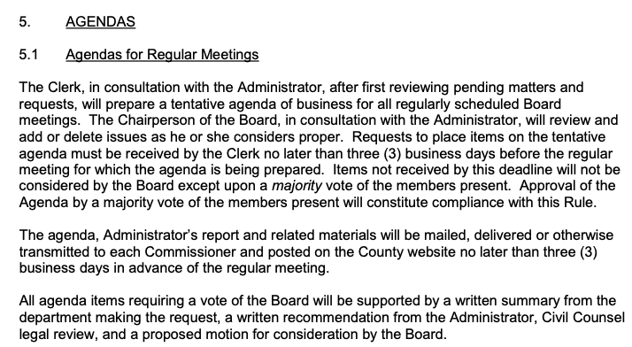
ECBOC's Rules of Procedure regarding Agendas
The Crooked River Lock Consortium had a meeting on 16 December 2020, its first meeting since 29 September 2011. Minutes for all of the meetings of the consortium are on the Emmet County web page for the Crooked River Lock.
The consortium meeting minutes may be accessed by clicking HERE.
Discussion during the consortium meeting was open and reasonable, making the entire minutes well worth reading.
Below is a section of the DRAFT 16 December 2020 CRLC meeting minutes
regarding a resolution boilerplate template.
The consortium meeting minutes may be accessed by clicking HERE.
Discussion during the consortium meeting was open and reasonable, making the entire minutes well worth reading.
Below is a section of the DRAFT 16 December 2020 CRLC meeting minutes
regarding a resolution boilerplate template.
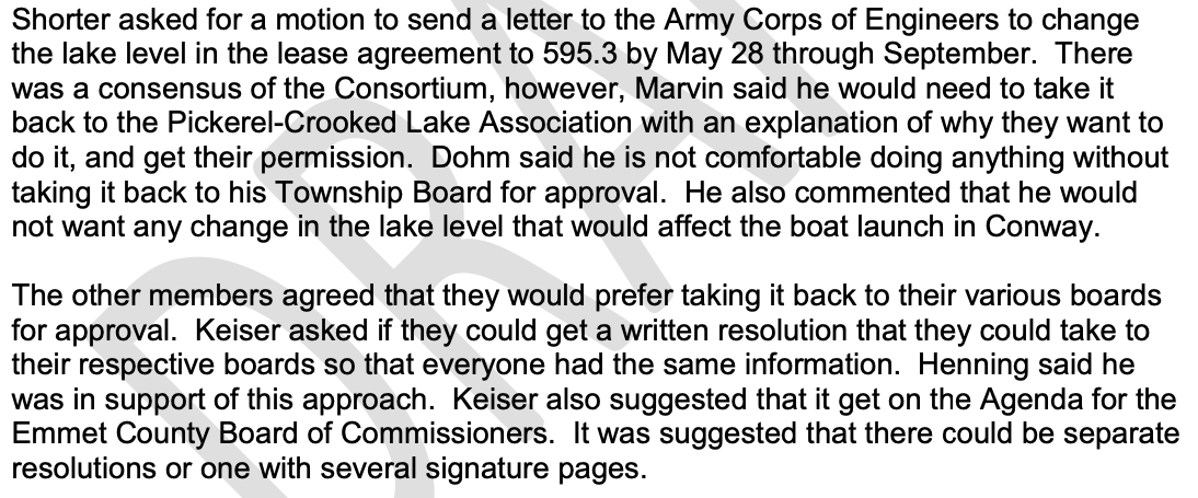
16 December 2020 ~ Section from the CRLC Meeting DRAFT Minutes...
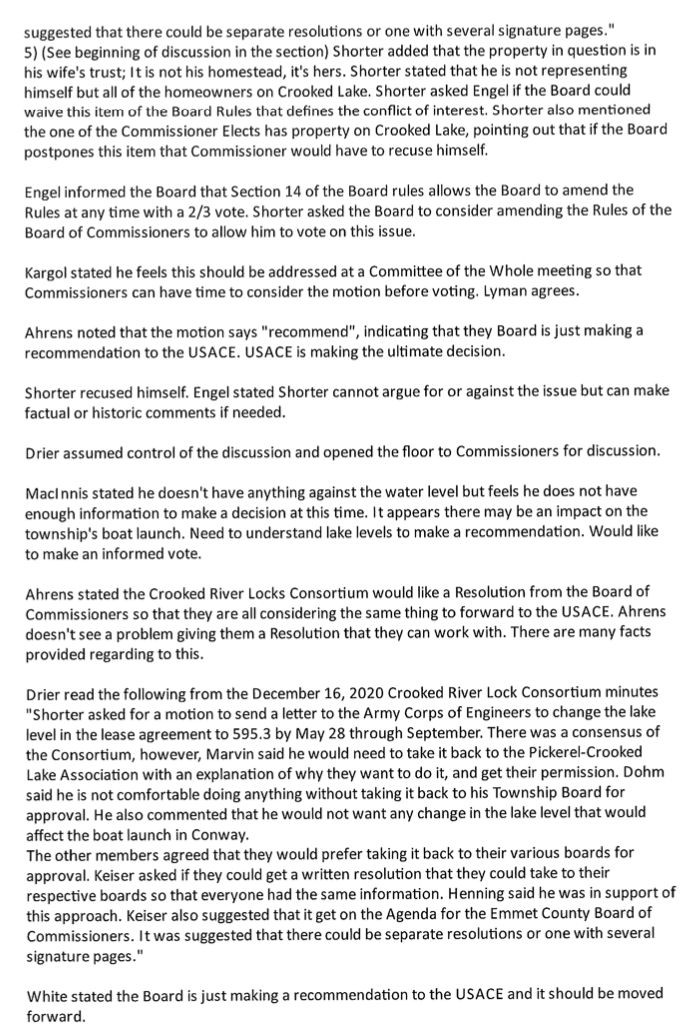
The suggestion at the consortium meeting, by Bear Creek Superintendent Keiser, was accepted as noted above in the DRAFT minutes. The minutes stated: "Keiser asked if they could get a written resolution that they could take to their respective boards so that everyone had the same information." It seemed it would be in order for the ECBOC to recommend a possible "boilerplate template resolution" to be used by each participating member of the Crooked River Lock Consortium, and by the ECBOC. Notice farther below, however, that the suggestion was not followed to merely ask the commissioners for a template for a possible resolution for the entities to discuss and then, possibly vote later, but rather the civil counsel made a resolution to which the ECBOC actually acted upon right then; the ECBOC feeling compelled by the wording of the resolution. These are two very different resolutions as discussed above, so that the "asked for resolution" suggested by Keiser, and the resolution brought forward to the ECBOC, were not in the same vein as what was suggested and ultimately voted.
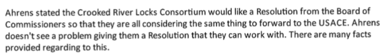
Even Commissioner Ahrens conceded at the 22 December 2020 meeting that the CRLC was looking for a possible resolution so the CRLC board members were all considering the same thing to forward to the USACE. He did not see a problem giving them a Resolution they can work with... This is not saying the CRLC was seeking an approved resolution from the ECBOC that very meeting.
Even Commissioner Ahrens conceded at the 22 December 2020 meeting that the CRLC was looking for a possible resolution so the CRLC board members were all considering the same thing to forward to the USACE. He did not see a problem giving them a Resolution they can work with... This is not saying the CRLC was seeking an approved resolution from the ECBOC that very meeting.
22 December 2020 ~ ECBOC Meeting Minutes
Below: Following the CRLC meeting above, the noted unheralded 22 December 2020 meeting was held.
22 December 2021 ~ Administrator's Report for the ECBOC meeting
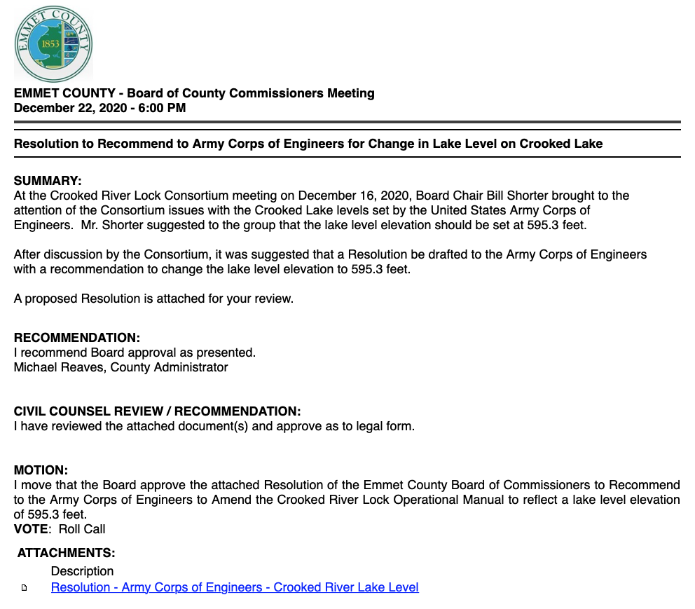
22 December 2020 ~ ECBOC Meeting Agenda (Placed LATE)
Minutes for the Emmet County Board of Commissioners Meeting
22 December 2020
22 December 2020
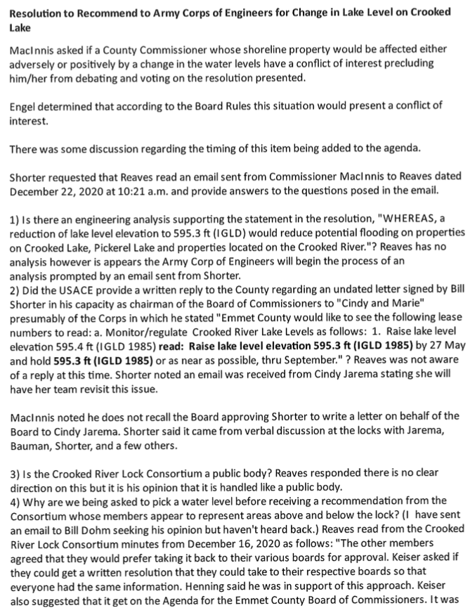
22 December 2020 ~ Minutes for the Emmet County Board of Commissioners Meeting (Page 1)
22 December 2020 ~ Minutes for the Emmet County Board of Commissioners Meeting (Page 2)
22 December 2020 ~ Minutes for the Emmet County Board of Commissioners Meeting (Page 3)
Below is the actual "Resolution of Emmet County Board of Commissioners to Recommend to the Army Corps of Engineers to Amend the Crooked River Lock Operational Manual" which passed 4 to 3 as noted in the 22 December 2020 minutes above.
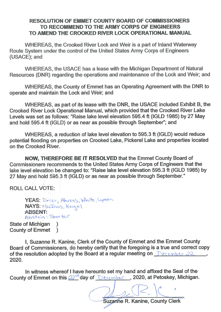
22 December 2020 ~ Resolution included in Minutes for the Emmet County Board of Commissioners Meeting (Passed as noted in the minutes above...)
23 December 2020 ~ Petoskey News Review
The minutes for the Emmet County Board of Commissioners' 21 January 2021 included the MULTITUDE of commenters mentioned farther above regarding the unacceptable lack of public notice, of their topic of the "lake level controversy". The commenters did NOT want the lake level lowered! Also noticed in the minutes was the lack of comment or reply (regarding the highly controversial topic) from the commissioners per their standard practice.
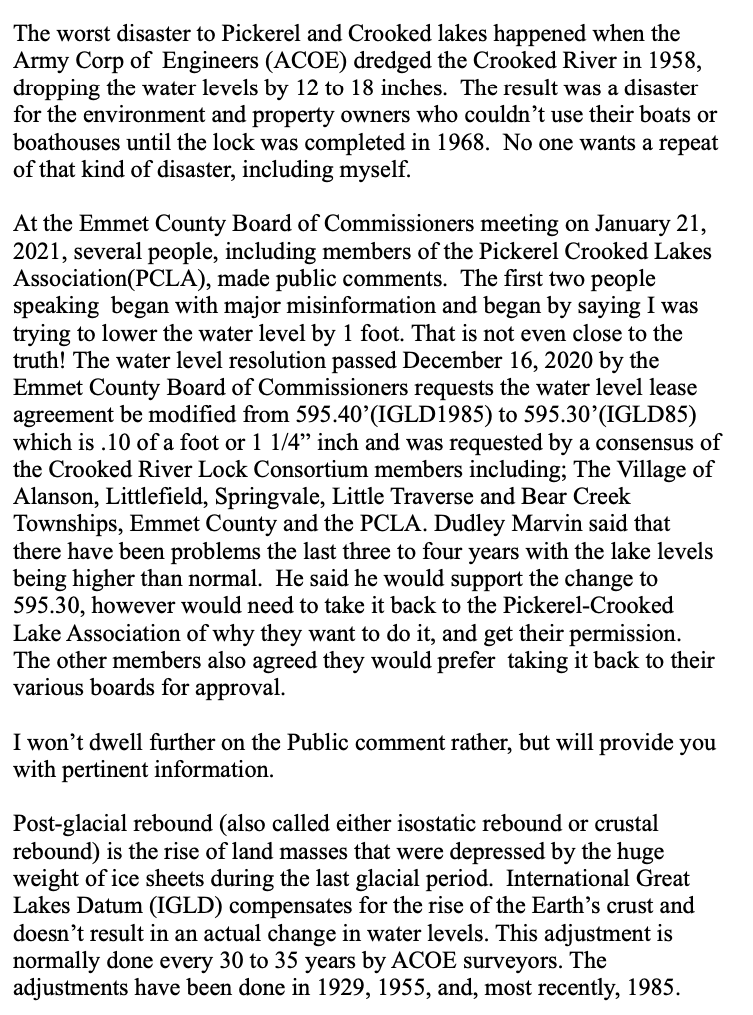
Summarized circumstances surrounding and affecting the lake level controversy... 28 January 2021
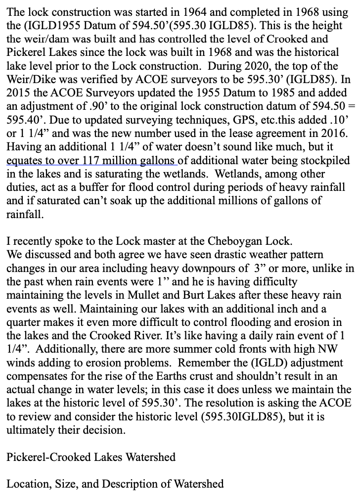
In recent years, the disagreement of Crooked Lake water level depends mostly on which side of Crooked Lake a residence or a business is located. The north side of Crooked Lake is more shallow, with the water depth on the south side being deeper. Thus, the north side residents wish for a higher water level to lessen the need to put out such long docks for boats, while that same higher water level creates damage and erosion of property frontage for property owners on the other side of the lake. Higher water levels also create overloading of the vital wetlands.
Check the actual lake depths on the following two maps, especially enjoyed by fisherman who appreciate Crooked Lake with its many underwater "brush shelters" placed in 1953 to harbor the fish. Click HERE and HERE to view the two maps with lake depths. Other than only for fishing knowledge, it is important to understand that Crooked Lake is naturally quite an overly shallow lake with the most depth marked at between 40 feet and a small portion at 60 feet in the main basin, and with those larger depths located more on the south side of Crooked Lake. North side depths mostly are marked from 5 to 10 feet with a 20 feet depth close to the entry from Pickerel Lake, thus requiring longer docks. Common sense prevails then, that lake level depths differ from the shallow areas to the deeper areas regarding water levels, even without the management of the locks.
Enter the United States Army Corps of Engineers which controls the water levels at the locks in Alanson with the auspices of the IGLD regulations. {The International Great Lakes Datum (IGLD) is a common reference system used to measure water level heights throughout the Great Lakes, their connecting waterways, and the St. Lawrence River System.} The tension in 2021 was noted in the 25 January 2021 Petoskey News Review article referencing the farther above noted tension between those who want the water level lowered to 595.3 feet (above sea level) from the present setting of 595.4 feet, amounts to the pros and cons for those on the north side, and those on the south side of Crooked Lake. Commenters, residents all from the north side of the lake, at the ECBOC 21 January 2021 meeting voiced that the 1/10 of a foot difference of water level at the lock, would make a difference of a foot water level on the lake, without saying how that was true (It was not true). The actual amount, however, needs to be explained for everyone to understand that the difference is 1/10 of a foot. The commenters ardently spoke of such issues as safety with boats hitting the bottom, having to buy as much as an additional 20 feet of dock, and other consequences for them if the lake level were to be lowered.
Commissioner Shorter in December 2020 told of having written to USACE regarding the lake level needing to go back to 595.3 level which was too shallow at the time after the 1958 river dredging, followed by residents’ frustration with the shallowness AFTER THAT dredging. So, then the level was raised to 595.4 IGLD (1985), which continues today. Shorter contends that this higher IGLD (1985) level creates flooding and erosion. Thus, the water level disagreement continues between the residents and businesses, depending where they are located on the lake, and their particular situations.
The following brochure provides some understanding of IGLD as it pertains to the water levels of Crooked Lake.
https://www.lre.usace.army.mil/Portals/69/docs/GreatLakesInfo/docs/IGLD/BrochureOnTheInternationalGreatLakesDatum1985.pdf
IGLD = International Great Lakes Datum had been done for 1955, and then again for 1985, which was “the central year of the period 1982-1988 during which water level information was collected for preparing the datum revision… The most significant change between IGLD 1955 and IGLD 1985 will be in the elevations assigned to water levels… The implementation and publication of IGLD 1985 will occur in January, 1992. This revised datum should be acceptable for general use in the Great Lakes-St. Lawrence River system for at least 25 years.”
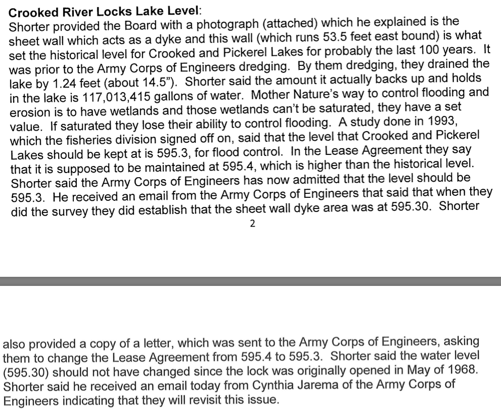
The lake water level before the dredging operations of Crooked River in 1958 was IGLD55 595.3. Shorter’s letter to the USACE on 28 November 2020 stated, “The Lock and Weir (Dike) structure were built as a correction measure to the water loss after dredging the Crooked River in 1958. The Weir (Dike) Level 595.3 IGLD 85 (595.4 IGLD 55) is the historical water level prior to the dredging and was used as the summertime level to maintain for years.”
IGLD “allows the Canadian and United States governments to authorize the continued use of the common datum by their respective agencies… The establishment and revision of this common datum for the United States and Canada is being performed under the auspices of the Coordinating Committee on Great Lakes Basic Hydraulic and Hydrologic Data.
The following web site reveals more information about the IGLD, including that because the IGLD is revised every 25–30 years, the existing 1985 IGLD will be revised over the next several years and replaced by IGLD (2020); thus the new IGLD is scheduled for tentative release in 2025.
IGLD - NOAA Tides & Currents
Noting that several governmental agencies work from scientific data, unless clerical/transcription, errors have been committed, it would seem that the mere resolution by local governmental entities cannot change the IGLD readings.
Replies from the Michigan USACE are being awaited and hopefully announced to the public, as to how they determine the correct level at the Crooked River Locks... scientific surveys as required for consistency of water levels in the interests of Canada and the United States, or by a local governmental resolution.
Check the actual lake depths on the following two maps, especially enjoyed by fisherman who appreciate Crooked Lake with its many underwater "brush shelters" placed in 1953 to harbor the fish. Click HERE and HERE to view the two maps with lake depths. Other than only for fishing knowledge, it is important to understand that Crooked Lake is naturally quite an overly shallow lake with the most depth marked at between 40 feet and a small portion at 60 feet in the main basin, and with those larger depths located more on the south side of Crooked Lake. North side depths mostly are marked from 5 to 10 feet with a 20 feet depth close to the entry from Pickerel Lake, thus requiring longer docks. Common sense prevails then, that lake level depths differ from the shallow areas to the deeper areas regarding water levels, even without the management of the locks.
Enter the United States Army Corps of Engineers which controls the water levels at the locks in Alanson with the auspices of the IGLD regulations. {The International Great Lakes Datum (IGLD) is a common reference system used to measure water level heights throughout the Great Lakes, their connecting waterways, and the St. Lawrence River System.} The tension in 2021 was noted in the 25 January 2021 Petoskey News Review article referencing the farther above noted tension between those who want the water level lowered to 595.3 feet (above sea level) from the present setting of 595.4 feet, amounts to the pros and cons for those on the north side, and those on the south side of Crooked Lake. Commenters, residents all from the north side of the lake, at the ECBOC 21 January 2021 meeting voiced that the 1/10 of a foot difference of water level at the lock, would make a difference of a foot water level on the lake, without saying how that was true (It was not true). The actual amount, however, needs to be explained for everyone to understand that the difference is 1/10 of a foot. The commenters ardently spoke of such issues as safety with boats hitting the bottom, having to buy as much as an additional 20 feet of dock, and other consequences for them if the lake level were to be lowered.
Commissioner Shorter in December 2020 told of having written to USACE regarding the lake level needing to go back to 595.3 level which was too shallow at the time after the 1958 river dredging, followed by residents’ frustration with the shallowness AFTER THAT dredging. So, then the level was raised to 595.4 IGLD (1985), which continues today. Shorter contends that this higher IGLD (1985) level creates flooding and erosion. Thus, the water level disagreement continues between the residents and businesses, depending where they are located on the lake, and their particular situations.
The following brochure provides some understanding of IGLD as it pertains to the water levels of Crooked Lake.
https://www.lre.usace.army.mil/Portals/69/docs/GreatLakesInfo/docs/IGLD/BrochureOnTheInternationalGreatLakesDatum1985.pdf
IGLD = International Great Lakes Datum had been done for 1955, and then again for 1985, which was “the central year of the period 1982-1988 during which water level information was collected for preparing the datum revision… The most significant change between IGLD 1955 and IGLD 1985 will be in the elevations assigned to water levels… The implementation and publication of IGLD 1985 will occur in January, 1992. This revised datum should be acceptable for general use in the Great Lakes-St. Lawrence River system for at least 25 years.”
The lake water level before the dredging operations of Crooked River in 1958 was IGLD55 595.3. Shorter’s letter to the USACE on 28 November 2020 stated, “The Lock and Weir (Dike) structure were built as a correction measure to the water loss after dredging the Crooked River in 1958. The Weir (Dike) Level 595.3 IGLD 85 (595.4 IGLD 55) is the historical water level prior to the dredging and was used as the summertime level to maintain for years.”
IGLD “allows the Canadian and United States governments to authorize the continued use of the common datum by their respective agencies… The establishment and revision of this common datum for the United States and Canada is being performed under the auspices of the Coordinating Committee on Great Lakes Basic Hydraulic and Hydrologic Data.
The following web site reveals more information about the IGLD, including that because the IGLD is revised every 25–30 years, the existing 1985 IGLD will be revised over the next several years and replaced by IGLD (2020); thus the new IGLD is scheduled for tentative release in 2025.
IGLD - NOAA Tides & Currents
Noting that several governmental agencies work from scientific data, unless clerical/transcription, errors have been committed, it would seem that the mere resolution by local governmental entities cannot change the IGLD readings.
Replies from the Michigan USACE are being awaited and hopefully announced to the public, as to how they determine the correct level at the Crooked River Locks... scientific surveys as required for consistency of water levels in the interests of Canada and the United States, or by a local governmental resolution.
"Resolutions spark concern on Crooked Lake, but no immediate change pending" headlined a 2 February 2021 Petoskey News Review article. In the article, Dudley Marvin, president of the Pickerel Crooked Lake Association said, "The resolution, even if passed by all the parties, wouldn't have the authority to bring about any direct action. Rather it would be a tool for advocacy in requesting the Army Corps of Engineers to step in."
Bill Shorter stated via ZOOM at the 8 February 2021 that he had not been able to attend
the previous 21 January 2021 ECBOC meeting to state his "Public Comment".
He thus had presented the following below letter to the commissioners for their 8 February 2021 COW meeting.
(Click on EACH Page to Enlarge)
the previous 21 January 2021 ECBOC meeting to state his "Public Comment".
He thus had presented the following below letter to the commissioners for their 8 February 2021 COW meeting.
(Click on EACH Page to Enlarge)
Shorter "Public Comment Letter" #1
|
Shorter "Public Comment Letter" #2
|
Shorter "Public Comment Letter" #3
|
Included in minutes for 8 February 2021: " [Shorter] Stated flooding problems do exist and are creating damage to the environment and property damage. Added that in 2012 the Tip of the Mi Watershed Council did a shoreline study of Crooked and Pickerel Lakes and found evidence of erosion on 270 parcels. 39% of that being on the two lakes."
ECBOC Voted 4_2 to rescind the USACE Resolution
8 February 2021
8 February 2021
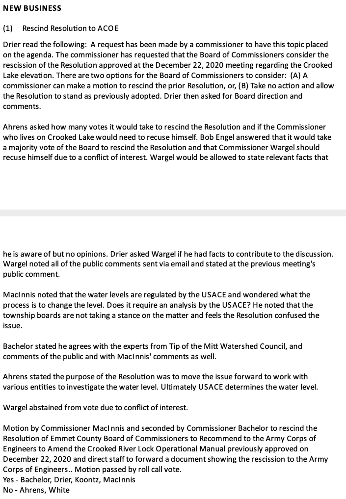
8 February 2021 ~ ECBOC Meeting Minutes
The minutes for the 8 February 2021 include the documents as listed in the summary below.
The documents may be accessed by clicking HERE.
The documents may be accessed by clicking HERE.
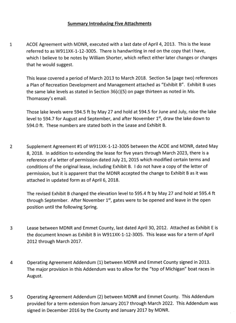
8 February 2021 ~ Included in minutes for the Emmet County Board of Commisioners
The Pickerel Lake Association penned a 9 February 2021 letter to the Crooked River Lock Consortium
expressing they "could not support a resolution to recommend to the USACE that the management of lake level elevation be changed to 'Raise lake level elevation 595.3 ft (IGLD 1985) by May and hold 595.3 (IGLD) or as near as possible through September.'" Their letter continued with their concerns, and may be read in the letter below.
(Click on EACH Page to Enlarge)
The Pickerel Lake Association penned a 9 February 2021 letter to the Crooked River Lock Consortium #1
|
The Pickerel Lake Association penned a 9 February 2021 letter to the Crooked River Lock Consortium #2
|
After much public pressure through public comment, the ECBOC on 8 February 2021 voted 4–2 to rescind their December 2020 resolution which encouraged a change in Crooked Lake water levels. Commissioners finally decided more study and analysis would be necessary before approaching the USACE with a water level recommendation. Commissioners must become aware of the appropriate process to change water levels… not just vote a resolution as they had approved in December 2020, without any knowledge directly from the USACE, or those of authority, and in-the-know. Not one of the involved multiple entities, with their individual interests, would have had the power to change the water level. Process is paramount. No matter the topic… Governmental PROCESS must be understood, and abided.
~~~~~~~~~~~~~~~~~~~~~
Below Questions and Answers fielded on e-mails dated 29 January 2021 > 5 February 2021 with Cynthia Jarema, Chief, Operations of the Detroit District of the USACE who explains governmental process in regards to water level facts of Crooked Lake for the involved entities by answering the following questions:
Q 1) IGLD [International Great Lakes Datum] did a survey for both IGLD 1955, and again, due to crustal movement, for IGLD 1985. I read that the implementation and publication of IGLD 1985 occurred in January, 1992. What is the present accurate IGLD for both 1955 and 1985 for the Crooked River Lock? Accurate is meant as "the datum that was established by a set of elevations consistent with one another for surveys taken within the time span 1982-1988.”
A 1) I believe your question on IGLD is regarding what the target lake elevation of Crooked Lake is in both IGLD55 and IGLD85 datums. The target summer elevation for the lake in IGLD55 datum is 594.5' and the target elevation converted to IGLD85 is 595.4'. There is a 0.9' numerical conversion between the IGLD55 and IGLD85 datums. A datum is a coordinate system that elevations can be spatially referenced to.
Q 2) Can communities legally, arbitrarily, change the IGLD for their own set of circumstances, for instance, for the Crooked River Lock?
A 2) As far as whether communities can change the IGLD, the answer is, no. Local communities cannot change IGLD. Datum conversion efforts (including Low Water Datum) are done through a bi-national coordinating committee led by the National Oceanic and Atmospheric Administration (NOAA) who is the charting authority. Communities may work with the necessary organizations to examine local target water level elevation changes for regulation purposes, though do not have authority to change the International Great Lakes Datum.
Q 3) What are considered to be the “necessary organizations of the community” for Crooked-Pickerel Lake? It seems so far, that the Crooked-Pickerel Lake Consortium, the four surrounding townships of the lake, and the county all want to have a voice. How do they fit into your term of “necessary organizations”? What about conservancy organizations, or any other local organization? AND HOW, exactly, do the organizations examine local target water level elevation changes for regulation purposes?”
A 3) The main organizations that would need to coordinate would be the Corps, the state of Michigan, and the local governments along Inland Route (the lease agreement is between the Corps and the State, and the State subleases operation to Emmet County), as well as property owners upstream and downstream of the lock and interest groups. Before any proposed change occurs, there would be an opportunity for any interested individual, group, or entity to voice comments.
Q 4) Does the USACE then ask for official data (documentation such as what?) from the organizations, and not just opinions? Do you now/already have any official examination data for this particular area that has been turned in? Has the USACE received any other examination results from any community organizations for the lock level?
A 4) Relevant information would be provided to which to make comments on. The Corps would accept any type of information provided to consider as well. At this point, there is no coordination planned for soliciting comments.
Q 5) Even if other townships, or a consensus of the consortium, is put forth in an approved resolution by the county or townships, is that enough for the USACE to change the lock/lake level?
A 5) A resolution/proposal in itself does not necessarily mean that a lake elevation change would take effect – there are many aspects to consider.
Q 6) It was stated at an Emmet County Board of Commissioners Meeting on 22 December 2020 that the county administrator stated he has "no analysis, however it appears the Army Corp of Engineers will begin the process of an analysis prompted by an email sent from Shorter.” Cynthia, is that true? Has, or will, the USACE begin the process of an analysis because someone has asked for it? What sorts of analyses are required?
A 6) The Corps has been looking into the request by Mr. Shorter, by pulling past documentation to better understand the request.
Q 7) Mr. Shorter has stated he wants the USACE to change the water level from 595.4 IGLD to 595.3. Does that actually equate to a FOOT lowering in the Crooked Lake level, or to a tenth of a foot lowering in the actual lake level? He is asking for the contractual Crooked River Lock Operational Manual between the county and the USACE to be changed. Is that legal and/or possible?
A 7) A water elevation change of one foot would not be a direct result of lowering the target elevation a tenth of a foot. There are other components that could affect water level change such as precipitation, wind, and water level gauge location.
Q 8) Do you believe the following to be true? I found this on the internet. Do you get any preview of how any IGLD 2020 surveys might change the IGLD when it is released? If so, what are you seeing for the Crooked River Lock and Lake?
“1985 IGLD will be revised over the next several years and replaced by IGLD (2020); thus the new IGLD is scheduled for tentative release in 2025.”
A 8) As for your question on impacts from the datum change to IGLD 2020, how I understand it, is NOAA does not intend to change the Low Water Datum for local areas, only the Great Lakes. The IGLD 2020 datum is separate from Low Water Datum.
~~~~~~~~~~~~~~~~~~~~~~~~~~
ADDED LATER by the Questioner: For additional information about "Low Water Datum" click HERE.
The 19 September 2023 Petoskey News Review reported the U.S. Army Corps of Engineers, in agreement with Emmet County, would keep the Crooked River Lock in Alanson closed for the remainder of the 2023 season as engineers perform critical maintenance. In usual circumstances, the Crooked River Lock would shift to weekend operations in October and would close in November for the winter.
The lock had had a temporary malfunction on 4 July 2023, but the Army Corps technicians were able to return it to full operation within 24 hours.
The lock's full closure was decided after the 24 August 2023 electrical malfunction, with replacement parts remaining on backorder. The locks usually result in passage for up to 40,000, recreational boat passengers during the spring/fall season.
The Army Corps of Engineers posts the hourly water level for Crooked River Lock and Weir.
Those specific figures may be viewed by clicking HERE.
Those specific figures may be viewed by clicking HERE.
Access YouTube which has an interesting video of a trip on
"The Crooked River Michigan Inland Waterway" by clicking HERE.
"The Crooked River Michigan Inland Waterway" by clicking HERE.
The lock suffered a temporary malfunction on 4 July 2023. The locks continue to see a decline in ticket sales over the last few years. With increased wages for seasonal employees, Emmet County's budget for the Crooked River Lock has been operating in a deficit. To meet this financial challenge, the daily pass rate has been raised from $10 to $15 by the Emmet County Board of Commissioners which operates the lock with a sub-lease through the Michigan Department of Natural Resources which leases the lock from the U.S. Army Corps of Engineers which owns the lock. The annual pass fee will remain at $45.
The Crooked River Lock will open 29 April 2024 with hopes that the maintenance issues of 2023 are in the past. 2024 plans include a backup generator on site. A large concern is the water level. County Administrator Boyer stated, "Once they decide to close those gates, we hope that will bring that water level up. It should bring it up, but it's probably going to be a little bit challenging this year. We've gone from record hights to potentialy record lows in a matter of four or five years." Crooked Lake levels are dependent on Mother Nature and the Crooked River Lock. It the lake level is too low, then people must extend lengths of the docks to have access to naviagble waters. Annually, 10,000 lockages are necessary for boaters to access, and enjoy, the 36-mile Inland Waterway, extending to Lake Huron. Access additional local information about Crooked River Lock by clicking HERE.
